This section of the site is all about the LS Postcode area, also known as the Leeds Postal Area. Explore links to the next level to learn more about specific postcode districts such as LS1.
The LS postcode area represents a group of postal districts in the Leeds area of the United Kingdom. The area code LS stands for the letters l and s in LeedS. LS has a population of 774,180 and covers an area of 930,786 hectares. Fun fact: 1.19% of the population of Great Britain lives in this area.
The postcode area falls within the following counties: West Yorkshire (95.27%), North Yorkshire (4.73%).
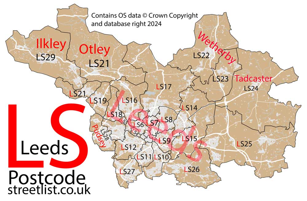
Post Towns and Postcode Districts for the LS Postcode
-
LS1 West YorkshireLS2 West YorkshireLS3 West YorkshireLS4 West YorkshireLS5 West YorkshireLS6 West YorkshireLS7 West YorkshireLS8 West YorkshireLS9 West YorkshireLS10 West YorkshireLS11 West YorkshireLS12 West YorkshireLS13 West YorkshireLS14 West YorkshireLS15 West YorkshireLS16 West YorkshireLS17 North Yorkshire (6%), West Yorkshire (93%)LS18 West YorkshireLS19 West YorkshireLS20 West YorkshireLS25 North Yorkshire (34%), West Yorkshire (65%)LS26 West YorkshireLS27 West YorkshireLS88 LS98 LS99
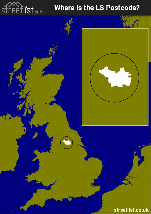
Where is the LS Postcode Area?
The LS Leeds Postcode is in the Yorkshire and the Humber Region of England. The postal area borders the following neighbouring postal areas: WF - Wakefield, BD - Bradford, YO - York and HG - Harrogate, and is located inland.
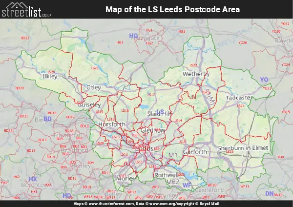
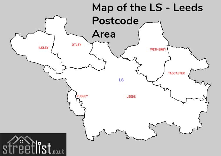
Map of the LS Leeds Postcode Area
Explore the LS Leeds postcode area by using our interactive map.
Postcode Districts within the LS Leeds Postcode Area
There are 29 postcode districts within the Leeds postcode area
A map showing the boundary of in relation to other areas
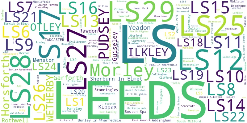
There are 10 towns within the Leeds postcode area.
| Unit | Area² |
|---|---|
| Hectares | 930,786² |
| Miles | 3,594² |
| Feet | 100,188,874,254² |
| Kilometres | 9,308² |
Postal Delivery Offices serving the LS Leeds Postcode Area
- Aireborough Delivery Office
- Bramley Delivery Office
- Chapeltown Road Delivery Office
- Garforth Delivery Office
- Harehills Delivery Office
- Holbeck Delivery Office
- Hunslet Delivery Office
- Ilkley Delivery Office
- Ireland Wood Delivery Office
- Leeds City Delivery Office
- Moortown Delivery Office
- Morley Delivery Office
- Otley Delivery Office
- Pudsey Delivery Office
- Seacroft Delivery Office
- Sheepscar Delivery Office
- Sherburn (ls) Delivery Office
- Tadcaster Delivery Office
- Tong Road Delivery Office
- Wetherby Delivery Office
- York Road Delivery Office
Councils with Postcodes in LS
Towns and Villages within the LS Leeds Postcode Area
- Aberford - village
- Addingham - village
- Addingham Moorside - otherSettlement
- Arthington - village
- Askwith - village
- Bardsey - village
- Barkston Ash - village
- Barwick in Elmet - village
- Bickerton - village
- Blubberhouses - village
- Boston Spa - village
- Bradford - city
- Bramham - village
- Bramhope - village
- Burley in Wharfedale - village
- Burley Woodhead - village
- Burton Salmon - village
- Calverley - village
- Church Fenton - village
- Clifford - village
- Collingham - village
- Colton - village
- Colton Lane End - otherSettlement
- Cowthorpe - village
- Denton - village
- East Carlton - village
- East Keswick - village
- Farnley - village
- Garforth - town
- Gildersome - village
- Great Preston - village
- Guiseley - town
- Harewood - village
- Hawksworth - village
- Healaugh - village
- Hillam - village
- Horsforth - Settlement
- Huby - village
- Hunsingore - village
- Ilkley - town
- Ingmanthorpe - village
- Kippax - village
- Kirk Deighton - village
- Leathley - village
- Ledsham - village
- Ledston Luck - village
- Leeds - city
- Linton - village
- Little Preston - village
- Little Ribston - village
- Lotherton - otherSettlement
- Lumby - village
- Menston - village
- Methley - village
- Micklefield - village
- Mickletown - village
- Middleton - village
- Monk Fryston - village
- Moor Side - village
- Morley - town
- Netherby - village
- Newton Kyme - village
- North Rigton - village
- Old Bramhope - village
- Otley - town
- Pool Bank - village
- Pool-in-Wharfedale - village
- Potterton - otherSettlement
- Pudsey - town
- Rawdon - village
- Robin Hood - village
- Rothwell - town
- Ryther - village
- Sandhills - village
- Saxton - village
- Scarcroft - village
- Scholes - village
- Shadwell - village
- Sherburn in Elmet - village
- Sicklinghall - village
- South Milford - village
- Steeton - otherSettlement
- Stutton - village
- Swillington - village
- Swillington Common - village
- Tadcaster - town
- Thorner - village
- Thorp Arch - village
- Towton - village
- Troydale - village
- Ulleskelf - village
- Wakefield - city
- Walton - village
- Weeton - village
- Weston - otherSettlement
- Wetherby - town
- Wighill - village
- Wike - village
- Woodend - village
- Yeadon - town