The LS10 postcode district is a postal district located in the LS Leeds postcode area with a population of 40,068 residents according to the 2021 England and Wales Census.
The area of the LS10 postcode district is 5.93 square miles which is 15.37 square kilometres or 3,798.31 acres.
Currently, the LS10 district has about 891 postcode units spread across 4 geographic postcode sectors.
Given that each sector allows for 400 unique postcode combinations, the district has a capacity of 1,600 postcodes. With 891 postcodes already in use, this leaves 709 units available.
The largest settlement in the LS10 postal code is LEEDS followed by Hunslet, and Middleton.
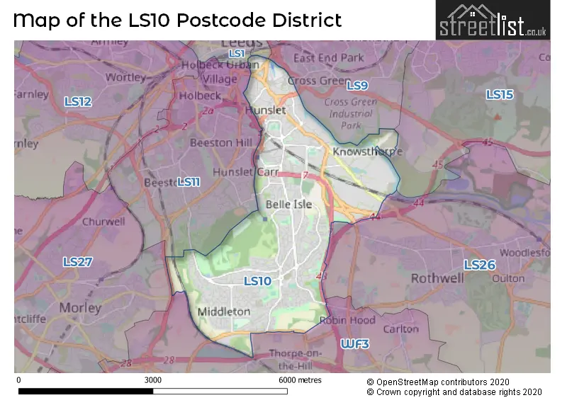
The LS10 Postcode shares a border with LS11 (LEEDS, Beeston), LS26 (Rothwell, Woodlesford, Methley), LS9 (LEEDS, Cross Green), WF3 (Tingley, Stanley, East Ardsley), LS15 (LEEDS, Barwick In Elmet, Scholes) and LS2 (LEEDS).
The primary settlement in the LS10 postcode district is Leeds, which is located in the county of West Yorkshire in England. Other significant settlements in the district include Hunslet, Hunslet Business Park, Belle Isle, Middleton, and Beeston Park. The most significant post town in the LS10 district is also Leeds.
For the district LS10, we have data on 5 postcode sectors. Here's a breakdown: The sector LS10 1, covers Leeds and Hunslet in West Yorkshire. The sector LS10 2, covers Leeds and Hunslet in West Yorkshire. The sector LS10 3, covers Leeds in West Yorkshire. The sector LS10 4, covers Leeds in West Yorkshire. The sector LS10 9 is non-geographic. It's often designated for PO Boxes, large organisations, or special services.

Map of the LS10 Postcode District
Explore the LS10 postcode district by using our free interactive map.
When it comes to local government, postal geography often disregards political borders. However, for a breakdown in the LS10 District: the district mostly encompasses the Leeds District (B) area with a total of 902 postcodes.
Recent House Sales in LS10
| Date | Price | Address |
|---|---|---|
| 25/10/2023 | £320,000 | Bowman Lane, Hunslet, Leeds, LS10 1HQ |
| 20/10/2023 | £240,000 | Mallard Close, Leeds, LS10 4QT |
| 06/10/2023 | £175,000 | West Grange Gardens, Leeds, LS10 3AT |
| 06/10/2023 | £40,000 | Exeter Drive, Leeds, LS10 3UE |
| 15/09/2023 | £250,000 | Ring Road, Middleton, Leeds, LS10 4AX |
| 11/09/2023 | £225,000 | Moor Flatts Avenue, Leeds, LS10 3SS |
| 08/09/2023 | £230,000 | Topliss Way, Leeds, LS10 4FQ |
| 08/09/2023 | £157,000 | Lea Park Close, Leeds, LS10 4RG |
| 08/09/2023 | £350,000 | Cable Place, Hunslet, Leeds, LS10 1GE |
| 01/09/2023 | £365,000 | Sharp House Road, Leeds, LS10 4GL |
Weather Forecast for LS10
Press Button to Show Forecast for Belle Isle
| Time Period | Icon | Description | Temperature | Rain Probability | Wind |
|---|---|---|---|---|---|
| 21:00 to 00:00 | Partly cloudy (night) | 5.0°C (feels like 3.0°C) | 2.00% | NE 7 mph |
Press Button to Show Forecast for Belle Isle
| Time Period | Icon | Description | Temperature | Rain Probability | Wind |
|---|---|---|---|---|---|
| 00:00 to 03:00 | Partly cloudy (night) | 3.0°C (feels like 2.0°C) | 1.00% | NNE 2 mph | |
| 03:00 to 06:00 | Clear night | 2.0°C (feels like 0.0°C) | 1.00% | NNW 4 mph | |
| 06:00 to 09:00 | Partly cloudy (day) | 3.0°C (feels like 1.0°C) | 2.00% | N 4 mph | |
| 09:00 to 12:00 | Cloudy | 7.0°C (feels like 5.0°C) | 5.00% | ENE 4 mph | |
| 12:00 to 15:00 | Overcast | 8.0°C (feels like 7.0°C) | 48.00% | NNE 4 mph | |
| 15:00 to 18:00 | Cloudy | 9.0°C (feels like 8.0°C) | 7.00% | ENE 4 mph | |
| 18:00 to 21:00 | Partly cloudy (day) | 8.0°C (feels like 6.0°C) | 6.00% | ENE 7 mph | |
| 21:00 to 00:00 | Cloudy | 5.0°C (feels like 3.0°C) | 8.00% | E 7 mph |
Press Button to Show Forecast for Belle Isle
| Time Period | Icon | Description | Temperature | Rain Probability | Wind |
|---|---|---|---|---|---|
| 00:00 to 03:00 | Cloudy | 4.0°C (feels like 3.0°C) | 8.00% | NNE 4 mph | |
| 03:00 to 06:00 | Cloudy | 3.0°C (feels like 2.0°C) | 7.00% | NE 4 mph | |
| 06:00 to 09:00 | Partly cloudy (day) | 4.0°C (feels like 2.0°C) | 7.00% | NE 4 mph | |
| 09:00 to 12:00 | Cloudy | 8.0°C (feels like 6.0°C) | 11.00% | E 7 mph | |
| 12:00 to 15:00 | Overcast | 10.0°C (feels like 8.0°C) | 15.00% | E 9 mph | |
| 15:00 to 18:00 | Cloudy | 10.0°C (feels like 8.0°C) | 18.00% | E 9 mph | |
| 18:00 to 21:00 | Cloudy | 9.0°C (feels like 6.0°C) | 17.00% | ENE 9 mph | |
| 21:00 to 00:00 | Cloudy | 6.0°C (feels like 4.0°C) | 17.00% | NE 7 mph |
Press Button to Show Forecast for Belle Isle
| Time Period | Icon | Description | Temperature | Rain Probability | Wind |
|---|---|---|---|---|---|
| 00:00 to 03:00 | Light rain | 6.0°C (feels like 3.0°C) | 46.00% | NNE 9 mph | |
| 03:00 to 06:00 | Light rain | 6.0°C (feels like 3.0°C) | 48.00% | NNE 11 mph | |
| 06:00 to 09:00 | Heavy rain | 7.0°C (feels like 3.0°C) | 72.00% | NNE 11 mph | |
| 09:00 to 12:00 | Heavy rain | 8.0°C (feels like 5.0°C) | 78.00% | NNE 13 mph | |
| 12:00 to 15:00 | Light rain | 9.0°C (feels like 6.0°C) | 58.00% | NNE 13 mph | |
| 15:00 to 18:00 | Heavy rain | 9.0°C (feels like 7.0°C) | 75.00% | N 11 mph | |
| 18:00 to 21:00 | Light rain | 9.0°C (feels like 8.0°C) | 46.00% | NNE 7 mph | |
| 21:00 to 00:00 | Partly cloudy (night) | 7.0°C (feels like 6.0°C) | 9.00% | SE 7 mph |
Where is the LS10 Postcode District?
The postcode district LS10 is located in the town of Leeds. Leeds is surrounded by several nearby towns. To the South West is Batley, which is approximately 5.39 miles away. Ossett is located to the South and is about 5.73 miles from Leeds. Normanton is situated to the South East, around 6.03 miles away. Pudsey is to the North West, at a distance of approximately 6.40 miles. Castleford is located to the East, about 7.72 miles away. Cleckheaton is situated to the West and is approximately 7.95 miles away from Leeds. Additionally, the distance from Leeds to the centre of London is around 166.59 miles.
The district is within the post town of LEEDS.
The sector has postcodes within the nation of England.
The LS10 Postcode District is in the Leeds region of West Yorkshire within the Yorkshire and The Humber.
| Postcode Sector | Delivery Office |
|---|---|
| LS10 1 | Hunslet Delivery Office |
| LS10 2 | Hunslet Delivery Office |
| LS10 3 | Hunslet Delivery Office |
| LS10 4 | Hunslet Delivery Office |
| L | S | 1 | 0 | - | X | X | X |
| L | S | 1 | 0 | Space | Numeric | Letter | Letter |
Tourist Attractions within the Postcode Area
We found 2 visitor attractions within the LS10 postcode area
| Leeds Discovery Centre |
|---|
| Museums & Art Galleries |
| Museum and / or Art Gallery |
| View Leeds Discovery Centre on Google Maps |
| Thwaite Mills Watermill |
| Museums & Art Galleries |
| Museum and / or Art Gallery |
| View Thwaite Mills Watermill on Google Maps |
Current Monthly Rental Prices
| # Bedrooms | Min Price | Max Price | Avg Price |
|---|---|---|---|
| £1,100 | £5,000 | £3,050 | |
| 1 | £500 | £925 | £810 |
| 2 | £650 | £2,150 | £1,224 |
| 3 | £925 | £1,950 | £1,261 |
| 4 | £1,000 | £2,000 | £1,400 |
Current House Prices
| # Bedrooms | Min Price | Max Price | Avg Price |
|---|---|---|---|
| £1 | £350,000 | £137,390 | |
| 1 | £50,000 | £222,500 | £131,132 |
| 2 | £65,000 | £850,000 | £208,884 |
| 3 | £100,000 | £290,000 | £206,734 |
| 4 | £175,000 | £495,000 | £336,574 |
| 5 | £420,000 | £425,000 | £423,333 |
Estate Agents who Operate in the LS10 District
| Logo | Name | Brand Name | Address | Contact Number | Total Properties |
|---|---|---|---|---|---|
 | Beeston | Manning Stainton | 293 Beeston Road, Leeds, LS11 7HX | 0113 519 1497 | 29 |
 | Leeds City | Martin & Co | 24-28 Bridge End Leeds LS1 4DJ | 0113 519 4987 | 15 |
 | Yorkshire | Strike | Nationwide | 0113 519 9126 | 14 |
 | Beeston | Morgan Estates | 188 Old Lane, Beeston, Leeds, LS11 8AG | 0113 519 9282 | 13 |
 | Leeds | Linley & Simpson | 1 Dock Street Leeds LS10 1NB | 0113 519 1008 | 12 |
| Type of Property | 2018 Average | 2018 Sales | 2017 Average | 2017 Sales | 2016 Average | 2016 Sales | 2015 Average | 2015 Sales |
|---|---|---|---|---|---|---|---|---|
| Detached | £216,891 | 48 | £198,811 | 41 | £190,595 | 41 | £187,754 | 33 |
| Semi-Detached | £139,845 | 203 | £129,028 | 210 | £125,047 | 156 | £105,744 | 157 |
| Terraced | £121,713 | 173 | £111,859 | 171 | £106,780 | 156 | £106,712 | 167 |
| Flats | £147,587 | 236 | £144,782 | 218 | £142,947 | 217 | £132,138 | 191 |