The LS14 postcode district is a postal district located in the LS Leeds postcode area with a population of 39,005 residents according to the 2021 England and Wales Census.
The area of the LS14 postcode district is 10.59 square miles which is 27.43 square kilometres or 6,777.46 acres.
Currently, the LS14 district has about 926 postcode units spread across 5 geographic postcode sectors.
Given that each sector allows for 400 unique postcode combinations, the district has a capacity of 2,000 postcodes. With 926 postcodes already in use, this leaves 1074 units available.
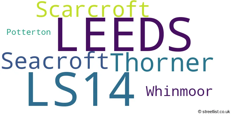
The largest settlement in the LS14 postal code is LEEDS followed by Seacroft, and Thorner.
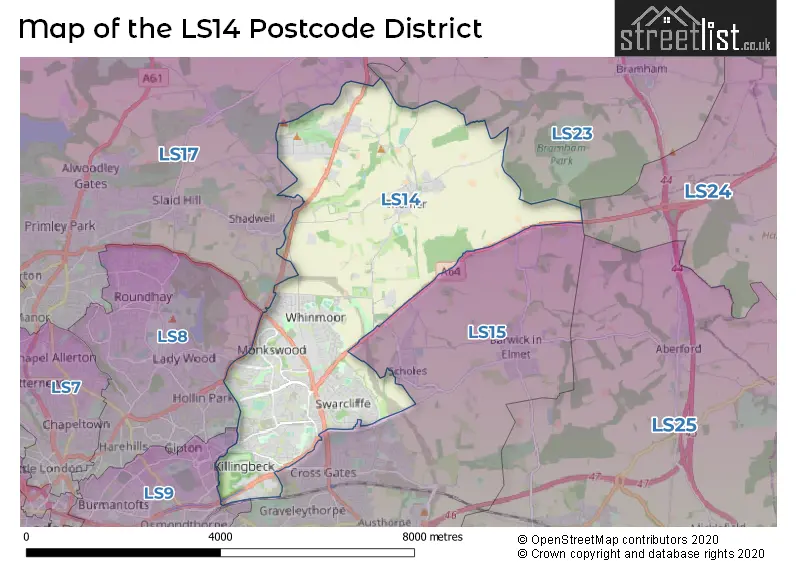
The LS14 Postcode shares a border with LS9 (LEEDS, Cross Green), LS15 (LEEDS, Barwick In Elmet, Scholes), LS23 (Boston Spa, Bramham, Clifford), LS8 (LEEDS, Roundhay) and LS17 (LEEDS, Bardsey, Harewood).
The primary settlement in the LS14 postcode district is Seacroft, located in the county of West Yorkshire. The post town for LS14 is Leeds, which is also in West Yorkshire.
For the district LS14, we have data on 6 postcode sectors. Here's a breakdown: The sector LS14 1, covers Leeds in West Yorkshire. The sector LS14 2, covers Leeds and Whinmoor in West Yorkshire. The sector LS14 3, covers Thorner and Scarcroft in West Yorkshire. The sector LS14 5, covers Leeds in West Yorkshire. The sector LS14 6, covers Leeds and Seacroft in West Yorkshire. The sector LS14 9 is non-geographic. It's often designated for PO Boxes, large organisations, or special services.

Map of the LS14 Postcode District
Explore the LS14 postcode district by using our free interactive map.
When it comes to local government, postal geography often disregards political borders. However, for a breakdown in the LS14 District: the district mostly encompasses the Leeds District (B) area with a total of 959 postcodes.
Recent House Sales in LS14
| Date | Price | Address |
|---|---|---|
| 12/10/2023 | £180,000 | Swarcliffe Drive, Leeds, LS14 5JN |
| 22/09/2023 | £123,500 | Ash Court, Leeds, LS14 6GH |
| 14/09/2023 | £125,000 | Coal Road, Leeds, LS14 1NN |
| 08/09/2023 | £148,500 | Stanks Rise, Leeds, LS14 5PY |
| 06/09/2023 | £173,000 | Croftside Close, Leeds, LS14 6DU |
| 30/08/2023 | £170,000 | North Parkway, Leeds, LS14 1EX |
| 29/08/2023 | £267,000 | Maple Way, Leeds, LS14 2HL |
| 29/08/2023 | £530,000 | Kirkhills, Thorner, Leeds, LS14 3JD |
| 25/08/2023 | £192,000 | Easdale Mount, Leeds, LS14 6QQ |
| 24/08/2023 | £205,000 | Monkswood Rise, Leeds, LS14 1DP |
Weather Forecast for LS14
Press Button to Show Forecast for Tropical World Roundhay
| Time Period | Icon | Description | Temperature | Rain Probability | Wind |
|---|---|---|---|---|---|
| 09:00 to 12:00 | Cloudy | 6.0°C (feels like 3.0°C) | 7.00% | N 11 mph | |
| 12:00 to 15:00 | Cloudy | 8.0°C (feels like 5.0°C) | 7.00% | N 11 mph | |
| 15:00 to 18:00 | Cloudy | 9.0°C (feels like 7.0°C) | 4.00% | N 9 mph | |
| 18:00 to 21:00 | Cloudy | 8.0°C (feels like 6.0°C) | 4.00% | NNE 7 mph | |
| 21:00 to 00:00 | Cloudy | 6.0°C (feels like 4.0°C) | 4.00% | W 4 mph |
Press Button to Show Forecast for Tropical World Roundhay
| Time Period | Icon | Description | Temperature | Rain Probability | Wind |
|---|---|---|---|---|---|
| 00:00 to 03:00 | Cloudy | 5.0°C (feels like 2.0°C) | 4.00% | WSW 9 mph | |
| 03:00 to 06:00 | Partly cloudy (night) | 4.0°C (feels like 1.0°C) | 2.00% | W 9 mph | |
| 06:00 to 09:00 | Cloudy | 5.0°C (feels like 2.0°C) | 10.00% | WNW 9 mph | |
| 09:00 to 12:00 | Partly cloudy (day) | 7.0°C (feels like 4.0°C) | 8.00% | NNW 11 mph | |
| 12:00 to 15:00 | Overcast | 8.0°C (feels like 6.0°C) | 13.00% | N 9 mph | |
| 15:00 to 18:00 | Light rain | 9.0°C (feels like 7.0°C) | 39.00% | N 7 mph | |
| 18:00 to 21:00 | Partly cloudy (day) | 7.0°C (feels like 5.0°C) | 4.00% | NNE 7 mph | |
| 21:00 to 00:00 | Partly cloudy (night) | 4.0°C (feels like 2.0°C) | 3.00% | NNE 4 mph |
Press Button to Show Forecast for Tropical World Roundhay
| Time Period | Icon | Description | Temperature | Rain Probability | Wind |
|---|---|---|---|---|---|
| 00:00 to 03:00 | Partly cloudy (night) | 3.0°C (feels like 1.0°C) | 2.00% | NNE 4 mph | |
| 03:00 to 06:00 | Cloudy | 2.0°C (feels like 0.0°C) | 6.00% | NNE 4 mph | |
| 06:00 to 09:00 | Cloudy | 3.0°C (feels like 1.0°C) | 6.00% | NNE 4 mph | |
| 09:00 to 12:00 | Cloudy | 6.0°C (feels like 4.0°C) | 7.00% | E 7 mph | |
| 12:00 to 15:00 | Cloudy | 8.0°C (feels like 6.0°C) | 12.00% | ESE 7 mph | |
| 15:00 to 18:00 | Overcast | 9.0°C (feels like 7.0°C) | 16.00% | ESE 7 mph | |
| 18:00 to 21:00 | Cloudy | 8.0°C (feels like 6.0°C) | 12.00% | E 9 mph | |
| 21:00 to 00:00 | Cloudy | 6.0°C (feels like 3.0°C) | 11.00% | E 7 mph |
Press Button to Show Forecast for Tropical World Roundhay
| Time Period | Icon | Description | Temperature | Rain Probability | Wind |
|---|---|---|---|---|---|
| 00:00 to 03:00 | Cloudy | 5.0°C (feels like 2.0°C) | 13.00% | ENE 7 mph | |
| 03:00 to 06:00 | Cloudy | 4.0°C (feels like 2.0°C) | 17.00% | NE 7 mph | |
| 06:00 to 09:00 | Light rain | 5.0°C (feels like 2.0°C) | 53.00% | ENE 7 mph | |
| 09:00 to 12:00 | Overcast | 7.0°C (feels like 4.0°C) | 25.00% | E 9 mph | |
| 12:00 to 15:00 | Light rain | 9.0°C (feels like 7.0°C) | 50.00% | E 9 mph | |
| 15:00 to 18:00 | Cloudy | 10.0°C (feels like 8.0°C) | 44.00% | E 11 mph | |
| 18:00 to 21:00 | Light rain | 9.0°C (feels like 6.0°C) | 43.00% | ENE 9 mph | |
| 21:00 to 00:00 | Light rain | 7.0°C (feels like 5.0°C) | 43.00% | ENE 9 mph |
Where is the LS14 Postcode District?
The LS14 postcode district is located in LEEDS. It is positioned nearby several towns: Wetherby to the North East (6.35 miles away), Tadcaster to the East (7.32 miles away), Castleford to the South East (9.10 miles away), Pudsey to the West (9.80 miles away), Normanton to the South (9.89 miles away), Knaresborough to the North (11.68 miles away), Batley to the South West (11.94 miles away), and Otley to the North West (11.96 miles away). Additionally, it is approximately 170.80 miles away from the center of London.
The district is within the post town of LEEDS.
The sector has postcodes within the nation of England.
The LS14 Postcode District is in the Leeds region of West Yorkshire within the Yorkshire and The Humber.
| Postcode Sector | Delivery Office |
|---|---|
| LS14 1 | Seacroft Delivery Office |
| LS14 2 | Seacroft Delivery Office |
| LS14 3 | Seacroft Delivery Office |
| LS14 5 | Seacroft Delivery Office |
| LS14 6 | Seacroft Delivery Office |
| L | S | 1 | 4 | - | X | X | X |
| L | S | 1 | 4 | Space | Numeric | Letter | Letter |
Current Monthly Rental Prices
| # Bedrooms | Min Price | Max Price | Avg Price |
|---|---|---|---|
| 1 | £500 | £750 | £629 |
| 2 | £670 | £1,100 | £818 |
| 3 | £900 | £1,900 | £1,300 |
| 4 | £1,700 | £3,500 | £2,600 |
Current House Prices
| # Bedrooms | Min Price | Max Price | Avg Price |
|---|---|---|---|
| 1 | £100,000 | £115,000 | £103,750 |
| 2 | £80,000 | £670,000 | £193,079 |
| 3 | £129,950 | £625,000 | £255,274 |
| 4 | £168,000 | £1,095,000 | £421,412 |
| 5 | £245,000 | £2,500,000 | £1,022,496 |
| 6 | £1,650,000 | £1,650,000 | £1,650,000 |
| 7 | £1,650,000 | £1,650,000 | £1,650,000 |
| 8 | £6,500,000 | £6,500,000 | £6,500,000 |
Estate Agents who Operate in the LS14 District
| Logo | Name | Brand Name | Address | Contact Number | Total Properties |
|---|---|---|---|---|---|
 | Crossgates | Manning Stainton | 62 Austhorpe Road, Leeds, LS15 8DX | 0113 519 1494 | 34 |
 | Crossgates | William H. Brown | 47 Station Road, Crossgates, Leeds, LS15 8DT | 0113 519 0427 | 13 |
 | Leeds | Furnell Residential | Hill Barn Cornmill Lane, Bardsey, Leeds, LS17 9EQ | 01937 227416 | 10 |
 | Yorkshire | Strike | Nationwide | 0113 519 9126 | 9 |
 | Crossgates | Reeds Rains | 22 Austhorpe Road, Leeds, LS15 8DX | 0113 519 0554 | 7 |
| Type of Property | 2018 Average | 2018 Sales | 2017 Average | 2017 Sales | 2016 Average | 2016 Sales | 2015 Average | 2015 Sales |
|---|---|---|---|---|---|---|---|---|
| Detached | £337,860 | 78 | £359,844 | 112 | £324,378 | 139 | £351,181 | 113 |
| Semi-Detached | £176,042 | 327 | £154,732 | 239 | £143,234 | 245 | £137,263 | 246 |
| Terraced | £143,592 | 132 | £136,243 | 149 | £131,326 | 150 | £117,282 | 168 |
| Flats | £110,332 | 52 | £102,127 | 47 | £86,292 | 109 | £111,911 | 64 |