The LS17 5 postcode sector is within the county of West Yorkshire.
Did you know? According to the 2021 Census, the LS17 5 postcode sector is home to a bustling 7,838 residents!
Given that each sector allows for 400 unique postcode combinations. Letters C, I, K, M, O and V are not allowed in the last two letters of a postcode. With 179 postcodes already in use, this leaves 221 units available.
The largest settlements in the LS17 5 postal code are LEEDS and Moortown.
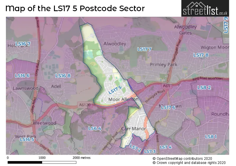
The LS17 5 Postcode shares a border with LS6 4 (LEEDS, Meanwood), LS7 2 (LEEDS, Meanwood), LS17 6 (LEEDS, Moortown), LS7 3 (LEEDS, Chapel Allerton, Potternewton), LS16 8 (LEEDS, Adel, Eccup) and LS17 7 (LEEDS, Alwoodley).
The sector is within the post town of LEEDS.
LS17 5 is a postcode sector within the LS17 postcode district which is within the LS Leeds postcode area.
The Royal Mail delivery office for the LS17 5 postal sector is the Moortown Delivery Office.
The area of the LS17 5 postcode sector is 0.93 square miles which is 2.42 square kilometres or 597.16 square acres.

Map of the LS17 5 Postcode Sector
Explore the LS17 5 postcode sector by using our free interactive map.
| L | S | 1 | 7 | - | 5 | X | X |
| L | S | 1 | 7 | Space | 5 | Letter | Letter |
Official List of Streets
LEEDS (91 Streets)
Moortown (4 Streets)
Unofficial Streets or Alternative Spellings
LEEDS
ALWOODLEY LANE LANE END COURT LINGFIELD APPROACH MOORLAND CRESCENT QUEENSHILL DRIVE STAINBECK LANE STAINBECK ROAD THE GROVE WENSLEY DRIVE WHINBROOK GARDENS WHINBROOK GROVEAlwoodley
THE AVENUE THE CRESCENT THE LANE BUCK STONE AVENUE BUCK STONE CLOSE BUCK STONE CRESCENT BUCK STONE DRIVE BUCK STONE GARDENS BUCK STONE GREEN BUCK STONE GROVE BUCK STONE MOUNT BUCK STONE OVAL BUCK STONE RISE BUCK STONE ROAD BUCK STONE WAY KING ALFREDS WAY MEANWOOD VALLEY TRAIL RING ROAD MEANWOOD RING ROAD MOORTOWN SCOTLAND MILL LANE STAIR FOOT LANEWeather Forecast for LS17 5
Press Button to Show Forecast for Camp Town
| Time Period | Icon | Description | Temperature | Rain Probability | Wind |
|---|---|---|---|---|---|
| 21:00 to 00:00 | Cloudy | 5.0°C (feels like 3.0°C) | 4.00% | N 7 mph |
Press Button to Show Forecast for Camp Town
| Time Period | Icon | Description | Temperature | Rain Probability | Wind |
|---|---|---|---|---|---|
| 00:00 to 03:00 | Cloudy | 4.0°C (feels like 1.0°C) | 3.00% | NNW 7 mph | |
| 03:00 to 06:00 | Clear night | 4.0°C (feels like 1.0°C) | 0.00% | NNW 9 mph | |
| 06:00 to 09:00 | Cloudy | 4.0°C (feels like 0.0°C) | 4.00% | NNW 9 mph | |
| 09:00 to 12:00 | Overcast | 6.0°C (feels like 2.0°C) | 8.00% | N 11 mph | |
| 12:00 to 15:00 | Cloudy | 8.0°C (feels like 5.0°C) | 4.00% | N 11 mph | |
| 15:00 to 18:00 | Cloudy | 9.0°C (feels like 7.0°C) | 4.00% | N 9 mph | |
| 18:00 to 21:00 | Cloudy | 8.0°C (feels like 6.0°C) | 4.00% | NNE 7 mph | |
| 21:00 to 00:00 | Cloudy | 6.0°C (feels like 4.0°C) | 4.00% | W 4 mph |
Press Button to Show Forecast for Camp Town
| Time Period | Icon | Description | Temperature | Rain Probability | Wind |
|---|---|---|---|---|---|
| 00:00 to 03:00 | Cloudy | 5.0°C (feels like 2.0°C) | 4.00% | W 9 mph | |
| 03:00 to 06:00 | Partly cloudy (night) | 4.0°C (feels like 1.0°C) | 2.00% | W 9 mph | |
| 06:00 to 09:00 | Cloudy | 5.0°C (feels like 2.0°C) | 7.00% | WNW 9 mph | |
| 09:00 to 12:00 | Partly cloudy (day) | 7.0°C (feels like 4.0°C) | 8.00% | NNW 11 mph | |
| 12:00 to 15:00 | Overcast | 8.0°C (feels like 6.0°C) | 13.00% | NNW 9 mph | |
| 15:00 to 18:00 | Light rain | 8.0°C (feels like 7.0°C) | 39.00% | N 7 mph | |
| 18:00 to 21:00 | Cloudy | 7.0°C (feels like 5.0°C) | 8.00% | NNE 7 mph | |
| 21:00 to 00:00 | Partly cloudy (night) | 4.0°C (feels like 2.0°C) | 3.00% | NNE 4 mph |
Press Button to Show Forecast for Camp Town
| Time Period | Icon | Description | Temperature | Rain Probability | Wind |
|---|---|---|---|---|---|
| 00:00 to 03:00 | Partly cloudy (night) | 3.0°C (feels like 1.0°C) | 2.00% | NNE 4 mph | |
| 03:00 to 06:00 | Cloudy | 2.0°C (feels like 0.0°C) | 6.00% | NNE 4 mph | |
| 06:00 to 09:00 | Cloudy | 3.0°C (feels like 1.0°C) | 6.00% | NNE 4 mph | |
| 09:00 to 12:00 | Cloudy | 6.0°C (feels like 4.0°C) | 7.00% | E 7 mph | |
| 12:00 to 15:00 | Cloudy | 8.0°C (feels like 6.0°C) | 11.00% | ESE 7 mph | |
| 15:00 to 18:00 | Overcast | 9.0°C (feels like 7.0°C) | 15.00% | ESE 7 mph | |
| 18:00 to 21:00 | Overcast | 8.0°C (feels like 6.0°C) | 16.00% | E 9 mph | |
| 21:00 to 00:00 | Cloudy | 6.0°C (feels like 3.0°C) | 12.00% | E 7 mph |
Press Button to Show Forecast for Camp Town
| Time Period | Icon | Description | Temperature | Rain Probability | Wind |
|---|---|---|---|---|---|
| 00:00 to 03:00 | Cloudy | 5.0°C (feels like 2.0°C) | 13.00% | ENE 7 mph | |
| 03:00 to 06:00 | Overcast | 4.0°C (feels like 2.0°C) | 20.00% | NE 7 mph | |
| 06:00 to 09:00 | Light rain | 5.0°C (feels like 2.0°C) | 50.00% | ENE 7 mph | |
| 09:00 to 12:00 | Overcast | 7.0°C (feels like 4.0°C) | 25.00% | ENE 9 mph | |
| 12:00 to 15:00 | Cloudy | 9.0°C (feels like 7.0°C) | 20.00% | E 9 mph | |
| 15:00 to 18:00 | Light rain | 10.0°C (feels like 8.0°C) | 49.00% | E 11 mph | |
| 18:00 to 21:00 | Light rain | 9.0°C (feels like 6.0°C) | 43.00% | ENE 9 mph | |
| 21:00 to 00:00 | Light rain | 7.0°C (feels like 5.0°C) | 43.00% | ENE 9 mph |
Schools and Places of Education Within the LS17 5 Postcode Sector
Alwoodley Primary School
Community school
Cranmer Rise, Leeds, West Yorkshire, LS17 5HX
Head: Mr G German
Ofsted Rating: Outstanding
Inspection: 2013-06-26 (3954 days ago)
Website: Visit Alwoodley Primary School Website
Phone: 01132686104
Number of Pupils: 484
Carr Manor Community School
Foundation school
Carr Manor Road, Leeds, West Yorkshire, LS17 5DJ
Head: Mr Simon Flowers
Ofsted Rating: Good
Inspection: 2023-11-16 (159 days ago)
Website: Visit Carr Manor Community School Website
Phone: 01133368400
Number of Pupils: 1477
St Paul's Catholic Primary School, a Voluntary Academy
Academy converter
Buckstone Crescent, Leeds, West Yorkshire, LS17 5ES
Head: Mr Philip Bowker
Ofsted Rating: Good
Inspection: 2021-11-03 (902 days ago)
Website: Visit St Paul's Catholic Primary School, a Voluntary Academy Website
Phone: 01132939901
Number of Pupils: 210
House Prices in the LS17 5 Postcode Sector
| Type of Property | 2018 Average | 2018 Sales | 2017 Average | 2017 Sales | 2016 Average | 2016 Sales | 2015 Average | 2015 Sales |
|---|---|---|---|---|---|---|---|---|
| Detached | £368,908 | 6 | £337,143 | 7 | £325,450 | 10 | £355,875 | 8 |
| Semi-Detached | £241,894 | 67 | £216,096 | 77 | £227,144 | 67 | £212,826 | 86 |
| Terraced | £215,000 | 1 | £150,213 | 4 | £201,000 | 1 | £165,165 | 3 |
| Flats | £90,183 | 6 | £103,382 | 11 | £97,933 | 15 | £96,100 | 5 |
Important Postcodes LS17 5 in the Postcode Sector
LS17 5DJ is the postcode for PRIMARY PHASE, Carr Manor Community School, Carr Manor Road, Carr Manor Primary Phase, Carr Manor Community School, Stainbeck Lane, Carr Mannor Secondary Phase, Carr Manor Community School, Carr Manor Road, Manor Wood Primary School, Carr Manor Road, SECONDARY PHASE, Carr Manor Community School, Carr Manor Road, Carr Manor High School, Carr Manor Road, and PRIMARY PHASE MODULAR BUILDING, Carr Manor Community School, Carr Manor Road
LS17 5ES is the postcode for ST PAULS CATHOLIC PRIMARY SCHOOL, BUCKSTONE CRESCENT, MOORTOWN, and St. Pauls Catholic Primary School, Buckstone Crescent
LS17 5HX is the postcode for MAIN BUILDING (BLOCK 1), Alwoodley Primary School, Cranmer Rise, LITTLE PEOPLE (ANNEX - BLOCK 2), Alwoodley Primary School, Cranmer Rise, and Alwoodley Primary School, Cranmer Rise
LS17 5NY is the postcode for Leeds City Council, Moor Allerton Library, Moor Allerton Centre
| The LS17 5 Sector is within these Local Authorities |
|
|---|---|
| The LS17 5 Sector is within these Counties |
|
| The LS17 5 Sector is within these Water Company Areas |
|