The LS27 9 postcode sector is within the county of West Yorkshire.
Did you know? According to the 2021 Census, the LS27 9 postcode sector is home to a bustling 8,762 residents!
Given that each sector allows for 400 unique postcode combinations. Letters C, I, K, M, O and V are not allowed in the last two letters of a postcode. With 227 postcodes already in use, this leaves 173 units available.
The LS27 9 postal code covers the settlement of Morley.
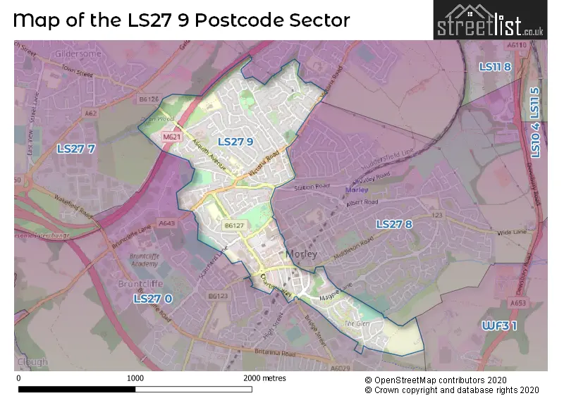
The LS27 9 Postcode shares a border with LS27 8 (Morley), WF3 1 (Tingley), LS27 0 (Morley) and LS27 7 (Morley).
The sector is within the post town of LEEDS.
LS27 9 is a postcode sector within the LS27 postcode district which is within the LS Leeds postcode area.
The Royal Mail delivery office for the LS27 9 postal sector is the Morley Delivery Office.
The area of the LS27 9 postcode sector is 0.77 square miles which is 1.98 square kilometres or 489.71 square acres.
The LS27 9 postcode sector is crossed by the M621 motorway.

Map of the LS27 9 Postcode Sector
Explore the LS27 9 postcode sector by using our free interactive map.
| L | S | 2 | 7 | - | 9 | X | X |
| L | S | 2 | 7 | Space | 9 | Letter | Letter |
Official List of Streets
Morley (154 Streets)
Unofficial Streets or Alternative Spellings
Morley
BAKER STREET BRUNTCLIFFE DRIVE CADMAN COURT CROFT HOUSE ROAD HANLEY ROAD MARSTON AVENUE MERLYN-REES AVENUE MIDDLETON ROAD NEW BANK STREET STATION ROAD TROY ROAD BANK COURT BERYL BURTON GARDENS CO-OPERATIVE STREET HARRWOOD MEWS KIRKNESS COURT MAGPIE LANE MORLEY BOTTOMS VICTORIA COURT WELLINGTON STREETWeather Forecast for LS27 9
Press Button to Show Forecast for New Brighton (West Yorkshire)
| Time Period | Icon | Description | Temperature | Rain Probability | Wind |
|---|---|---|---|---|---|
| 18:00 to 21:00 | Cloudy | 7.0°C (feels like 4.0°C) | 6.00% | NNE 9 mph | |
| 21:00 to 00:00 | Partly cloudy (night) | 5.0°C (feels like 2.0°C) | 3.00% | NE 7 mph |
Press Button to Show Forecast for New Brighton (West Yorkshire)
| Time Period | Icon | Description | Temperature | Rain Probability | Wind |
|---|---|---|---|---|---|
| 00:00 to 03:00 | Partly cloudy (night) | 3.0°C (feels like 1.0°C) | 2.00% | NNE 2 mph | |
| 03:00 to 06:00 | Clear night | 2.0°C (feels like 0.0°C) | 1.00% | NNW 4 mph | |
| 06:00 to 09:00 | Partly cloudy (day) | 2.0°C (feels like 0.0°C) | 2.00% | N 4 mph | |
| 09:00 to 12:00 | Cloudy | 6.0°C (feels like 4.0°C) | 6.00% | NE 4 mph | |
| 12:00 to 15:00 | Overcast | 7.0°C (feels like 6.0°C) | 9.00% | NE 4 mph | |
| 15:00 to 18:00 | Cloudy | 9.0°C (feels like 8.0°C) | 7.00% | ENE 4 mph | |
| 18:00 to 21:00 | Partly cloudy (day) | 7.0°C (feels like 5.0°C) | 6.00% | ENE 7 mph | |
| 21:00 to 00:00 | Cloudy | 4.0°C (feels like 2.0°C) | 8.00% | E 7 mph |
Press Button to Show Forecast for New Brighton (West Yorkshire)
| Time Period | Icon | Description | Temperature | Rain Probability | Wind |
|---|---|---|---|---|---|
| 00:00 to 03:00 | Cloudy | 3.0°C (feels like 2.0°C) | 8.00% | NNE 4 mph | |
| 03:00 to 06:00 | Partly cloudy (night) | 3.0°C (feels like 1.0°C) | 5.00% | NE 4 mph | |
| 06:00 to 09:00 | Partly cloudy (day) | 3.0°C (feels like 1.0°C) | 7.00% | NE 4 mph | |
| 09:00 to 12:00 | Cloudy | 7.0°C (feels like 5.0°C) | 11.00% | E 7 mph | |
| 12:00 to 15:00 | Overcast | 9.0°C (feels like 7.0°C) | 15.00% | E 9 mph | |
| 15:00 to 18:00 | Cloudy | 9.0°C (feels like 7.0°C) | 18.00% | E 9 mph | |
| 18:00 to 21:00 | Cloudy | 8.0°C (feels like 6.0°C) | 17.00% | ENE 11 mph | |
| 21:00 to 00:00 | Cloudy | 6.0°C (feels like 3.0°C) | 17.00% | NE 7 mph |
Press Button to Show Forecast for New Brighton (West Yorkshire)
| Time Period | Icon | Description | Temperature | Rain Probability | Wind |
|---|---|---|---|---|---|
| 00:00 to 03:00 | Light rain | 5.0°C (feels like 2.0°C) | 45.00% | NNE 9 mph | |
| 03:00 to 06:00 | Light rain | 5.0°C (feels like 2.0°C) | 50.00% | NNE 11 mph | |
| 06:00 to 09:00 | Heavy rain | 6.0°C (feels like 3.0°C) | 73.00% | NNE 11 mph | |
| 09:00 to 12:00 | Heavy rain | 7.0°C (feels like 4.0°C) | 79.00% | NNE 13 mph | |
| 12:00 to 15:00 | Light rain | 8.0°C (feels like 5.0°C) | 58.00% | NNE 13 mph | |
| 15:00 to 18:00 | Heavy rain | 9.0°C (feels like 6.0°C) | 75.00% | N 11 mph | |
| 18:00 to 21:00 | Light rain | 9.0°C (feels like 7.0°C) | 46.00% | NNE 7 mph | |
| 21:00 to 00:00 | Partly cloudy (night) | 7.0°C (feels like 5.0°C) | 9.00% | SE 7 mph |
Schools and Places of Education Within the LS27 9 Postcode Sector
Asquith Primary School
Community school
Horsfall Street, Leeds, West Yorkshire, LS27 9QY
Head: Mrs Trudie Southward
Ofsted Rating: Good
Inspection: 2019-05-08 (1814 days ago)
Website: Visit Asquith Primary School Website
Phone: 01133075550
Number of Pupils: 436
Churwell Primary School
Community school
Westwood Side, Leeds, West Yorkshire, LS27 9HR
Head: Mrs Rupa Barson
Ofsted Rating: Good
Inspection: 2020-02-12 (1534 days ago)
Website: Visit Churwell Primary School Website
Phone: 01132527437
Number of Pupils: 461
Morley Victoria Primary School
Community school
Victoria Road, Leeds, West Yorkshire, LS27 9NW
Head: Headteacher Joanne Wood
Ofsted Rating: Outstanding
Inspection: 2023-12-07 (140 days ago)
Website: Visit Morley Victoria Primary School Website
Phone: 01132535253
Number of Pupils: 467
Queenswood School
Other independent school
Queen Street, Leeds, West Yorkshire, LS27 9EB
Head: Mrs J A Tanner
Ofsted Rating: Good
Inspection: 2023-10-12 (196 days ago)
Website: Visit Queenswood School Website
Phone: 01132534033
Number of Pupils: 20
St Francis Catholic Primary School, Morley
Voluntary aided school
Highcliffe Road, Leeds, West Yorkshire, LS27 9LX
Head: Mrs Grace Gibbons
Ofsted Rating: Good
Inspection: 2018-12-11 (1962 days ago)
Website: Visit St Francis Catholic Primary School, Morley Website
Phone: 01133230554
Number of Pupils: 238
House Prices in the LS27 9 Postcode Sector
| Type of Property | 2018 Average | 2018 Sales | 2017 Average | 2017 Sales | 2016 Average | 2016 Sales | 2015 Average | 2015 Sales |
|---|---|---|---|---|---|---|---|---|
| Detached | £263,258 | 31 | £235,583 | 24 | £247,363 | 15 | £268,007 | 30 |
| Semi-Detached | £154,183 | 32 | £152,706 | 47 | £145,595 | 41 | £139,830 | 54 |
| Terraced | £135,960 | 63 | £128,579 | 66 | £157,332 | 70 | £129,151 | 65 |
| Flats | £94,892 | 19 | £89,409 | 11 | £74,023 | 34 | £113,292 | 44 |
Important Postcodes LS27 9 in the Postcode Sector
LS27 9DY is the postcode for Leeds City Council, Town Hall, Queen Street, Morley, Morley Town Hall, Queen Street, and Leeds City Council, Town Hall, Queen Street
LS27 9EB is the postcode for High Point House, 88 Queen Street
LS27 9EE is the postcode for Siegen Manor, Wesley Street
LS27 9EN is the postcode for The Fountain Medical Centre, Little Fountain Street
LS27 9HR is the postcode for Churwell Primary School, Westwood Side, Morley, JAPA, Churwell Primary School, Westwood Side, and Churwell Primary School, Westwood Side
LS27 9JP is the postcode for MORLEY LEISURE CENTRE, QUEENSWAY
LS27 9LX is the postcode for St. Francis Catholic Primary School, Highcliffe Road
LS27 9NB is the postcode for Morley Health Centre, Corporation Street, Morley Health Centre, Corporation Street, Morley, West Yorkshire Fire & Rescue Service, Fire Station, Corporation Street, and West Yorkshire Police, Morley Police Station, Corporation Street
LS27 9NW is the postcode for Morley Victoria Primary School, Victoria Road, and KS1 BLOCK, Morley Victoria Primary School, Victoria Road
LS27 9QY is the postcode for ORIGINAL BUILDING, Asquith Primary School, Horsfall Street, KEY STAGE 2, Asquith Primary School, Horsfall Street, and Asquith Primary School, Horsfall Street
| The LS27 9 Sector is within these Local Authorities |
|
|---|---|
| The LS27 9 Sector is within these Counties |
|
| The LS27 9 Sector is within these Water Company Areas |
|