The LS5 postcode district is a postal district located in the LS Leeds postcode area with a population of 8,441 residents according to the 2021 England and Wales Census.
The area of the LS5 postcode district is 1.04 square miles which is 2.69 square kilometres or 663.60 acres.
Currently, the LS5 district has about 204 postcode units spread across 2 geographic postcode sectors.
Given that each sector allows for 400 unique postcode combinations, the district has a capacity of 800 postcodes. With 204 postcodes already in use, this leaves 596 units available.
The largest settlements in the LS5 postal code are LEEDS and Kirkstall.
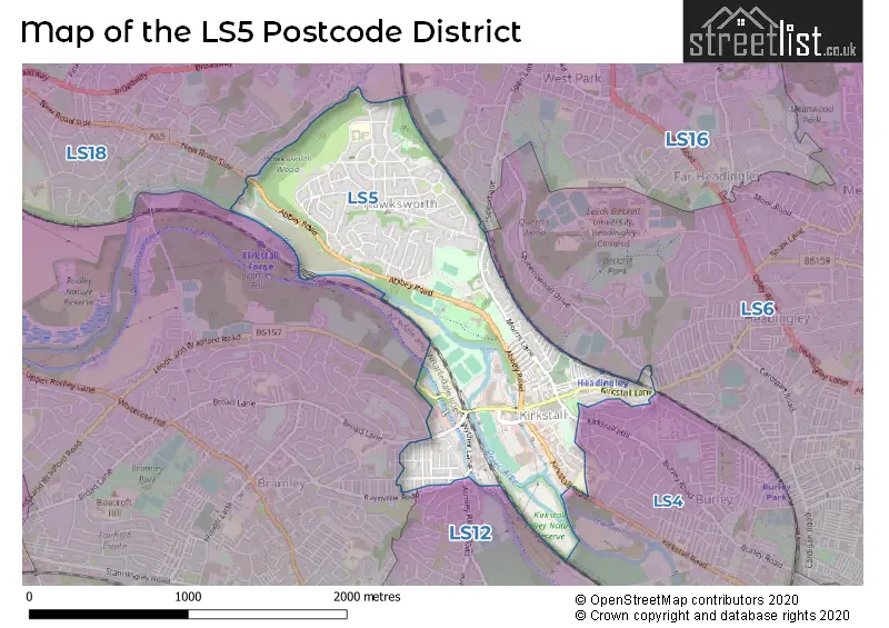
The LS5 Postcode shares a border with LS6 (LEEDS, Headingley, Meanwood), LS12 (LEEDS, Armley), LS13 (LEEDS, Bramley, Rodley), LS4 (LEEDS), LS18 (Horsforth) and LS16 (LEEDS, Bramhope, Adel).
The primary settlement in the LS5 postcode district is Leeds, which is located in the West Yorkshire county. Leeds is also the post town for this district. Other significant settlements in the LS5 postcode district include Kirkstall and Wyther Park Industrial Estate.
For the district LS5, we have data on 2 postcode sectors. Here's a breakdown: The sector LS5 2, covers Leeds in West Yorkshire. The sector LS5 3, covers Leeds and Kirkstall in West Yorkshire.

Map of the LS5 Postcode District
Explore the LS5 postcode district by using our free interactive map.
When it comes to local government, postal geography often disregards political borders. However, for a breakdown in the LS5 District: the district mostly encompasses the Leeds District (B) area with a total of 204 postcodes.
Recent House Sales in LS5
| Date | Price | Address |
|---|---|---|
| 06/10/2023 | £282,500 | Southolme Close, Leeds, LS5 3LP |
| 06/10/2023 | £157,500 | Vicarage Mews, Leeds, LS5 3GZ |
| 22/09/2023 | £237,500 | Morris Grove, Leeds, LS5 3EZ |
| 21/09/2023 | £189,950 | Hawksworth Grove, Leeds, LS5 3NB |
| 13/09/2023 | £109,000 | Sandford Road, Leeds, LS5 3AZ |
| 12/09/2023 | £220,000 | Vesper Gardens, Leeds, LS5 3NS |
| 08/09/2023 | £221,500 | Norman Street, Leeds, LS5 3JN |
| 08/09/2023 | £125,000 | Kepstorn Close, Leeds, LS5 3EL |
| 06/09/2023 | £130,000 | Vesper Road, Leeds, LS5 3NU |
| 30/08/2023 | £300,750 | Lea Farm Drive, Leeds, LS5 3QG |
Weather Forecast for LS5
Press Button to Show Forecast for Kirkstall
| Time Period | Icon | Description | Temperature | Rain Probability | Wind |
|---|---|---|---|---|---|
| 12:00 to 15:00 | Cloudy | 8.0°C (feels like 6.0°C) | 43.00% | NNW 7 mph | |
| 15:00 to 18:00 | Cloudy | 10.0°C (feels like 8.0°C) | 5.00% | NNE 7 mph | |
| 18:00 to 21:00 | Partly cloudy (day) | 8.0°C (feels like 5.0°C) | 2.00% | NNE 9 mph | |
| 21:00 to 00:00 | Partly cloudy (night) | 5.0°C (feels like 3.0°C) | 2.00% | NE 4 mph |
Press Button to Show Forecast for Kirkstall
| Time Period | Icon | Description | Temperature | Rain Probability | Wind |
|---|---|---|---|---|---|
| 00:00 to 03:00 | Clear night | 3.0°C (feels like 1.0°C) | 1.00% | N 2 mph | |
| 03:00 to 06:00 | Clear night | 2.0°C (feels like 0.0°C) | 1.00% | NNW 4 mph | |
| 06:00 to 09:00 | Partly cloudy (day) | 3.0°C (feels like 0.0°C) | 2.00% | N 4 mph | |
| 09:00 to 12:00 | Cloudy | 7.0°C (feels like 5.0°C) | 9.00% | NE 4 mph | |
| 12:00 to 15:00 | Overcast | 8.0°C (feels like 7.0°C) | 17.00% | E 4 mph | |
| 15:00 to 18:00 | Cloudy | 9.0°C (feels like 8.0°C) | 8.00% | ENE 4 mph | |
| 18:00 to 21:00 | Partly cloudy (day) | 8.0°C (feels like 6.0°C) | 5.00% | ENE 7 mph | |
| 21:00 to 00:00 | Partly cloudy (night) | 4.0°C (feels like 2.0°C) | 5.00% | E 4 mph |
Press Button to Show Forecast for Kirkstall
| Time Period | Icon | Description | Temperature | Rain Probability | Wind |
|---|---|---|---|---|---|
| 00:00 to 03:00 | Cloudy | 3.0°C (feels like 2.0°C) | 6.00% | NNE 2 mph | |
| 03:00 to 06:00 | Partly cloudy (night) | 3.0°C (feels like 1.0°C) | 5.00% | NNE 4 mph | |
| 06:00 to 09:00 | Partly cloudy (day) | 3.0°C (feels like 1.0°C) | 7.00% | NNE 4 mph | |
| 09:00 to 12:00 | Cloudy | 8.0°C (feels like 6.0°C) | 10.00% | E 7 mph | |
| 12:00 to 15:00 | Overcast | 10.0°C (feels like 8.0°C) | 15.00% | E 9 mph | |
| 15:00 to 18:00 | Cloudy | 10.0°C (feels like 8.0°C) | 17.00% | E 9 mph | |
| 18:00 to 21:00 | Cloudy | 9.0°C (feels like 6.0°C) | 16.00% | ENE 9 mph | |
| 21:00 to 00:00 | Cloudy | 6.0°C (feels like 4.0°C) | 14.00% | NE 7 mph |
Press Button to Show Forecast for Kirkstall
| Time Period | Icon | Description | Temperature | Rain Probability | Wind |
|---|---|---|---|---|---|
| 00:00 to 03:00 | Cloudy | 5.0°C (feels like 2.0°C) | 17.00% | NNE 9 mph | |
| 03:00 to 06:00 | Overcast | 6.0°C (feels like 2.0°C) | 22.00% | NNE 11 mph | |
| 06:00 to 09:00 | Light rain | 7.0°C (feels like 3.0°C) | 55.00% | NNE 11 mph | |
| 09:00 to 12:00 | Heavy rain | 8.0°C (feels like 5.0°C) | 79.00% | NNE 13 mph | |
| 12:00 to 15:00 | Light rain | 9.0°C (feels like 6.0°C) | 58.00% | NNE 13 mph | |
| 15:00 to 18:00 | Heavy rain | 9.0°C (feels like 7.0°C) | 74.00% | N 11 mph | |
| 18:00 to 21:00 | Cloudy | 9.0°C (feels like 7.0°C) | 17.00% | N 7 mph | |
| 21:00 to 00:00 | Clear night | 7.0°C (feels like 5.0°C) | 8.00% | SE 7 mph |
Where is the LS5 Postcode District?
The LS5 postcode district is located in Leeds, a town in the West Yorkshire area. It is situated near several nearby towns, including Pudsey, Bradford, Batley, and Otley. The distance from LS5 to London is approximately 171.68 miles.
The district is within the post town of LEEDS.
The sector has postcodes within the nation of England.
The LS5 Postcode District is in the Leeds region of West Yorkshire within the Yorkshire and The Humber.
| Postcode Sector | Delivery Office |
|---|---|
| LS5 2 | Leeds City Delivery Office |
| LS5 3 | Leeds City Delivery Office |
| L | S | 5 | - | X | X | X |
| L | S | 5 | Space | Numeric | Letter | Letter |
Tourist Attractions within the Postcode Area
We found 2 visitor attractions within the LS5 postcode area
| Abbey House Museum |
|---|
| Museums & Art Galleries |
| Museum and / or Art Gallery |
| View Abbey House Museum on Google Maps |
| Kirkstall Abbey |
| Museums & Art Galleries |
| Museum and / or Art Gallery |
| View Kirkstall Abbey on Google Maps |
Current Monthly Rental Prices
| # Bedrooms | Min Price | Max Price | Avg Price |
|---|---|---|---|
| 1 | £475 | £995 | £630 |
| 2 | £850 | £1,300 | £980 |
| 3 | £950 | £1,350 | £1,150 |
| 4 | £325 | £1,700 | £1,264 |
| 5 | £325 | £325 | £325 |
| 25 | £555 | £555 | £555 |
Current House Prices
| # Bedrooms | Min Price | Max Price | Avg Price |
|---|---|---|---|
| £90,000 | £90,000 | £90,000 | |
| 2 | £140,000 | £225,000 | £176,249 |
| 3 | £180,000 | £344,950 | £277,858 |
| 4 | £350,000 | £350,000 | £350,000 |
Estate Agents who Operate in the LS5 District
| Logo | Name | Brand Name | Address | Contact Number | Total Properties |
|---|---|---|---|---|---|
 | Horsforth | Manning Stainton | 113 New Road Side, Horsforth, Leeds, LS18 4QD | 0113 519 1584 | 7 |
 | Leeds | Lets Live Leeds | Regent House, 2 Regent Road Horsforth Leeds LS18 4NP | 0113 519 3991 | 5 |
 | Headingley | Right Let Leeds | 87 Otley Road, Headingley, Leeds, LS6 3PS | 0113 519 7133 | 3 |
 | London | OpenRent | 39 Great Windmill Street London W1D 7LX | 020 3322 3265 | 3 |
 | National | Urban Lettings | 2 Park House, Coventry, CV1 2FL | 03300 532981 | 2 |
| Type of Property | 2018 Average | 2018 Sales | 2017 Average | 2017 Sales | 2016 Average | 2016 Sales | 2015 Average | 2015 Sales |
|---|---|---|---|---|---|---|---|---|
| Detached | £227,038 | 12 | £191,621 | 12 | £215,936 | 14 | £203,333 | 6 |
| Semi-Detached | £186,050 | 65 | £177,480 | 45 | £174,981 | 53 | £160,864 | 48 |
| Terraced | £154,622 | 52 | £147,245 | 40 | £141,692 | 43 | £131,544 | 57 |
| Flats | £102,850 | 58 | £113,613 | 20 | £100,153 | 19 | £90,300 | 15 |