The LS7 postcode district is a postal district located in the LS Leeds postcode area with a population of 31,823 residents according to the 2021 England and Wales Census.
The area of the LS7 postcode district is 2.44 square miles which is 6.31 square kilometres or 1,558.73 acres.
Currently, the LS7 district has about 674 postcode units spread across 4 geographic postcode sectors.
Given that each sector allows for 400 unique postcode combinations, the district has a capacity of 1,600 postcodes. With 674 postcodes already in use, this leaves 926 units available.
The largest settlements in the LS7 postal code are LEEDS and Chapel Allerton.
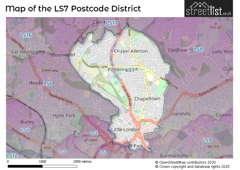
The LS7 Postcode shares a border with LS6 (LEEDS, Headingley, Meanwood), LS9 (LEEDS, Cross Green), LS2 (LEEDS), LS8 (LEEDS, Roundhay) and LS17 (LEEDS, Bardsey, Harewood).
In the LS7 postcode district, the primary settlement is Leeds, which belongs to the county of West Yorkshire in England. Leeds has the highest count of 107. Other significant settlements in LS7 include Meanwood and Penraevon Industrial Estate. The most significant post town in the LS7 postcode district is Leeds.
For the district LS7, we have data on 5 postcode sectors. Here's a breakdown: The sector LS7 1, covers Leeds in West Yorkshire. The sector LS7 2, covers Leeds in West Yorkshire. The sector LS7 3, covers Leeds in West Yorkshire. The sector LS7 4, covers Leeds in West Yorkshire. The sector LS7 9 is non-geographic. It's often designated for PO Boxes, large organisations, or special services.

Map of the LS7 Postcode District
Explore the LS7 postcode district by using our free interactive map.
When it comes to local government, postal geography often disregards political borders. However, for a breakdown in the LS7 District: the district mostly encompasses the Leeds District (B) area with a total of 680 postcodes.
Recent House Sales in LS7
| Date | Price | Address |
|---|---|---|
| 18/10/2023 | £385,000 | St Martins View, Leeds, LS7 3LB |
| 22/09/2023 | £250,000 | Dominion Avenue, Leeds, LS7 4NN |
| 15/09/2023 | £207,000 | Potternewton Crescent, Leeds, LS7 2DY |
| 07/09/2023 | £330,000 | Carrholm Grove, Leeds, LS7 2NR |
| 31/08/2023 | £420,000 | Wensley View, Leeds, LS7 3QL |
| 25/08/2023 | £330,000 | Wensley Road, Leeds, LS7 2LX |
| 25/08/2023 | £432,500 | Alberta Avenue, Leeds, LS7 4LX |
| 25/08/2023 | £245,000 | Miles Hill Avenue, Leeds, LS7 2EL |
| 24/08/2023 | £256,500 | Gledhow Park Avenue, Leeds, LS7 4JL |
| 23/08/2023 | £380,000 | Charnley Drive, Leeds, LS7 4ST |
Weather Forecast for LS7
Press Button to Show Forecast for Potternewton
| Time Period | Icon | Description | Temperature | Rain Probability | Wind |
|---|---|---|---|---|---|
| 12:00 to 15:00 | Cloudy | 8.0°C (feels like 6.0°C) | 11.00% | N 9 mph | |
| 15:00 to 18:00 | Cloudy | 9.0°C (feels like 7.0°C) | 5.00% | NNE 7 mph | |
| 18:00 to 21:00 | Sunny day | 7.0°C (feels like 5.0°C) | 2.00% | NNE 9 mph | |
| 21:00 to 00:00 | Partly cloudy (night) | 4.0°C (feels like 2.0°C) | 2.00% | NE 4 mph |
Press Button to Show Forecast for Potternewton
| Time Period | Icon | Description | Temperature | Rain Probability | Wind |
|---|---|---|---|---|---|
| 00:00 to 03:00 | Clear night | 2.0°C (feels like 0.0°C) | 1.00% | N 4 mph | |
| 03:00 to 06:00 | Clear night | 1.0°C (feels like -1.0°C) | 1.00% | N 4 mph | |
| 06:00 to 09:00 | Partly cloudy (day) | 2.0°C (feels like 0.0°C) | 2.00% | N 7 mph | |
| 09:00 to 12:00 | Cloudy | 6.0°C (feels like 5.0°C) | 9.00% | NE 4 mph | |
| 12:00 to 15:00 | Overcast | 8.0°C (feels like 7.0°C) | 10.00% | ENE 4 mph | |
| 15:00 to 18:00 | Cloudy | 9.0°C (feels like 8.0°C) | 8.00% | ENE 4 mph | |
| 18:00 to 21:00 | Partly cloudy (day) | 7.0°C (feels like 5.0°C) | 5.00% | ENE 7 mph | |
| 21:00 to 00:00 | Partly cloudy (night) | 4.0°C (feels like 2.0°C) | 5.00% | E 4 mph |
Press Button to Show Forecast for Potternewton
| Time Period | Icon | Description | Temperature | Rain Probability | Wind |
|---|---|---|---|---|---|
| 00:00 to 03:00 | Cloudy | 3.0°C (feels like 2.0°C) | 5.00% | NNE 2 mph | |
| 03:00 to 06:00 | Partly cloudy (night) | 2.0°C (feels like 0.0°C) | 5.00% | NNE 4 mph | |
| 06:00 to 09:00 | Partly cloudy (day) | 3.0°C (feels like 1.0°C) | 7.00% | NNE 4 mph | |
| 09:00 to 12:00 | Cloudy | 8.0°C (feels like 5.0°C) | 10.00% | E 7 mph | |
| 12:00 to 15:00 | Overcast | 10.0°C (feels like 8.0°C) | 15.00% | E 9 mph | |
| 15:00 to 18:00 | Cloudy | 10.0°C (feels like 7.0°C) | 17.00% | E 9 mph | |
| 18:00 to 21:00 | Cloudy | 9.0°C (feels like 6.0°C) | 16.00% | ENE 9 mph | |
| 21:00 to 00:00 | Cloudy | 6.0°C (feels like 3.0°C) | 14.00% | NE 7 mph |
Press Button to Show Forecast for Potternewton
| Time Period | Icon | Description | Temperature | Rain Probability | Wind |
|---|---|---|---|---|---|
| 00:00 to 03:00 | Cloudy | 5.0°C (feels like 2.0°C) | 17.00% | NNE 9 mph | |
| 03:00 to 06:00 | Overcast | 5.0°C (feels like 2.0°C) | 22.00% | NNE 11 mph | |
| 06:00 to 09:00 | Light rain | 6.0°C (feels like 3.0°C) | 55.00% | NNE 11 mph | |
| 09:00 to 12:00 | Heavy rain | 8.0°C (feels like 4.0°C) | 79.00% | NNE 13 mph | |
| 12:00 to 15:00 | Light rain | 9.0°C (feels like 6.0°C) | 58.00% | NNE 13 mph | |
| 15:00 to 18:00 | Heavy rain | 9.0°C (feels like 6.0°C) | 74.00% | N 11 mph | |
| 18:00 to 21:00 | Cloudy | 9.0°C (feels like 7.0°C) | 17.00% | N 7 mph | |
| 21:00 to 00:00 | Partly cloudy (night) | 7.0°C (feels like 5.0°C) | 8.00% | SE 7 mph |
Where is the LS7 Postcode District?
The LS7 postcode district is located in LEEDS. It is nearby the towns of Pudsey, Batley, Normanton, and Dewsbury. In addition, this postcode district is approximately 170.6 miles away from the center of London.
The district is within the post town of LEEDS.
The sector has postcodes within the nation of England.
The LS7 Postcode District is in the Leeds region of West Yorkshire within the Yorkshire and The Humber.
| Postcode Sector | Delivery Office |
|---|---|
| LS7 1 | Sheepscar Delivery Office |
| LS7 1 | Chapeltown Road Delivery Office |
| LS7 2 | Sheepscar Delivery Office |
| LS7 2 | Chapeltown Road Delivery Office |
| LS7 3 | Sheepscar Delivery Office |
| LS7 3 | Chapeltown Road Delivery Office |
| LS7 4 | Sheepscar Delivery Office |
| LS7 4 | Chapeltown Road Delivery Office |
| L | S | 7 | - | X | X | X |
| L | S | 7 | Space | Numeric | Letter | Letter |
Current Monthly Rental Prices
| # Bedrooms | Min Price | Max Price | Avg Price |
|---|---|---|---|
| 1 | £400 | £850 | £680 |
| 2 | £850 | £1,595 | £1,145 |
| 3 | £1,000 | £2,250 | £1,385 |
| 4 | £1,550 | £1,895 | £1,723 |
| 5 | £602 | £1,950 | £872 |
| 6 | £546 | £3,276 | £1,911 |
Current House Prices
| # Bedrooms | Min Price | Max Price | Avg Price |
|---|---|---|---|
| £61,000 | £61,000 | £61,000 | |
| 1 | £95,000 | £220,000 | £161,500 |
| 2 | £70,000 | £600,000 | £212,321 |
| 3 | £230,000 | £600,000 | £337,953 |
| 4 | £230,000 | £700,000 | £386,383 |
| 5 | £260,000 | £600,000 | £430,000 |
| 6 | £375,000 | £375,000 | £375,000 |
Estate Agents who Operate in the LS7 District
| Logo | Name | Brand Name | Address | Contact Number | Total Properties |
|---|---|---|---|---|---|
 | Chapel Allerton | Northwood | 64 Harrogate Road, Leeds, LS7 4LA | 0113 519 4398 | 17 |
 | Chapel Allerton | Stoneacre Properties | 184 Harrogate Road, Leeds, LS7 4NZ | 0113 519 3736 | 13 |
 | Chapel Allerton | Linley & Simpson | 116-118 Harrogate Road, Chapel Allerton, Leeds, LS7 4NY | 0113 519 5826 | 9 |
 | Roundhay | Manning Stainton | 659 Roundhay Road, Leeds, LS8 4BA | 0113 519 1653 | 8 |
 | Leeds | Preston Baker | 470 Roundhay Road Roundhay Leeds LS8 2HU | 0113 519 3782 | 5 |
| Type of Property | 2018 Average | 2018 Sales | 2017 Average | 2017 Sales | 2016 Average | 2016 Sales | 2015 Average | 2015 Sales |
|---|---|---|---|---|---|---|---|---|
| Detached | £326,676 | 27 | £361,275 | 18 | £292,695 | 20 | £277,829 | 25 |
| Semi-Detached | £239,146 | 152 | £215,454 | 150 | £213,107 | 135 | £198,231 | 153 |
| Terraced | £186,773 | 115 | £181,479 | 128 | £182,758 | 147 | £172,004 | 124 |
| Flats | £119,025 | 203 | £129,479 | 93 | £125,895 | 95 | £130,009 | 68 |