The LU6 postcode district is a postal district located in the LU Luton postcode area with a population of 34,490 residents according to the 2021 England and Wales Census.
The area of the LU6 postcode district is 23.60 square miles which is 61.12 square kilometres or 15,103.12 acres.
Currently, the LU6 district has about 728 postcode units spread across 3 geographic postcode sectors.
Given that each sector allows for 400 unique postcode combinations, the district has a capacity of 1,200 postcodes. With 728 postcodes already in use, this leaves 472 units available.
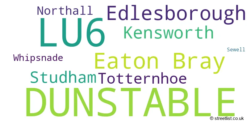
The largest settlement in the LU6 postal code is DUNSTABLE followed by Eaton Bray, and Edlesborough.
The LU6 Postcode shares a border with AL3 (ST. ALBANS, Redbourn, Markyate), LU1 (LUTON, Caddington, Slip End), LU5 (Houghton Regis, DUNSTABLE, Toddington), LU7 (LEIGHTON BUZZARD, Pitstone, Wing), HP2 (HEMEL HEMPSTEAD, Hemel Hempstead Industrial Estate, Gaddesden Row) and HP4 (BERKHAMSTED, Northchurch, Potten End).
The primary settlement in the LU6 postcode district is Dunstable, which is located in the county of Bedfordshire. Other significant settlements in this district include Eaton Bray, Edlesborough, Sewell, Totternhoe, Kensworth, Northall, Studham, and Whipsnade. The most significant post town in this district is Dunstable.
For the district LU6, we have data on 4 postcode sectors. Here's a breakdown: The sector LU6 1, covers Dunstable in Bedfordshire. The sector LU6 2, covers Eaton Bray and Studham and Dunstable in Bedfordshire. The sector LU6 2, covers Edlesborough in Buckinghamshire. The sector LU6 3, covers Dunstable and Kensworth in Bedfordshire. The sector LU6 9 is non-geographic. It's often designated for PO Boxes, large organisations, or special services.

Map of the LU6 Postcode District
Explore the LU6 postcode district by using our free interactive map.
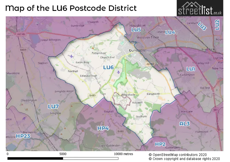
When it comes to local government, postal geography often disregards political borders. However, for a breakdown in the LU6 District: the district mostly encompasses the Central Bedfordshire (643 postcodes), and finally, the Buckinghamshire area (66 postcodes).
Recent House Sales in LU6
| Date | Price | Address |
|---|---|---|
| 26/10/2023 | £510,000 | Royce Close, Dunstable, LU6 2NT |
| 22/09/2023 | £70,000 | High Street South, Dunstable, LU6 3SZ |
| 19/09/2023 | £180,000 | Oakwell Close, Dunstable, LU6 2PY |
| 15/09/2023 | £60,000 | High Street South, Dunstable, LU6 3HP |
| 15/09/2023 | £320,000 | Vauxhall Way, Dunstable, LU6 1BF |
| 15/09/2023 | £130,000 | Albion Street, Dunstable, LU6 1SB |
| 12/09/2023 | £630,000 | Eaton Park, Eaton Bray, Dunstable, LU6 2SR |
| 08/09/2023 | £600,000 | Friary Field, Dunstable, LU6 3HZ |
| 08/09/2023 | £185,000 | Abbey Mews, Dunstable, LU6 3PJ |
| 01/09/2023 | £550,000 | Coombe Drive, Dunstable, LU6 2AE |
Weather Forecast for LU6
Press Button to Show Forecast for Dunstable
| Time Period | Icon | Description | Temperature | Rain Probability | Wind |
|---|---|---|---|---|---|
| 18:00 to 21:00 | Cloudy | 8.0°C (feels like 6.0°C) | 15.00% | NNE 9 mph | |
| 21:00 to 00:00 | Clear night | 6.0°C (feels like 3.0°C) | 0.00% | NNE 9 mph |
Press Button to Show Forecast for Dunstable
| Time Period | Icon | Description | Temperature | Rain Probability | Wind |
|---|---|---|---|---|---|
| 00:00 to 03:00 | Clear night | 4.0°C (feels like 0.0°C) | 0.00% | NNW 9 mph | |
| 03:00 to 06:00 | Partly cloudy (night) | 3.0°C (feels like -1.0°C) | 1.00% | NNW 9 mph | |
| 06:00 to 09:00 | Partly cloudy (day) | 3.0°C (feels like -1.0°C) | 1.00% | NNW 9 mph | |
| 09:00 to 12:00 | Cloudy | 6.0°C (feels like 3.0°C) | 3.00% | N 13 mph | |
| 12:00 to 15:00 | Cloudy | 8.0°C (feels like 5.0°C) | 3.00% | N 11 mph | |
| 15:00 to 18:00 | Cloudy | 9.0°C (feels like 7.0°C) | 4.00% | N 13 mph | |
| 18:00 to 21:00 | Cloudy | 9.0°C (feels like 6.0°C) | 4.00% | NNE 9 mph | |
| 21:00 to 00:00 | Cloudy | 6.0°C (feels like 4.0°C) | 4.00% | NE 7 mph |
Press Button to Show Forecast for Dunstable
| Time Period | Icon | Description | Temperature | Rain Probability | Wind |
|---|---|---|---|---|---|
| 00:00 to 03:00 | Cloudy | 5.0°C (feels like 3.0°C) | 6.00% | NNE 7 mph | |
| 03:00 to 06:00 | Cloudy | 4.0°C (feels like 1.0°C) | 8.00% | N 7 mph | |
| 06:00 to 09:00 | Cloudy | 4.0°C (feels like 2.0°C) | 9.00% | N 7 mph | |
| 09:00 to 12:00 | Overcast | 6.0°C (feels like 3.0°C) | 9.00% | N 9 mph | |
| 12:00 to 15:00 | Overcast | 8.0°C (feels like 5.0°C) | 10.00% | NNE 11 mph | |
| 15:00 to 18:00 | Overcast | 9.0°C (feels like 7.0°C) | 8.00% | NNE 11 mph | |
| 18:00 to 21:00 | Partly cloudy (day) | 8.0°C (feels like 5.0°C) | 3.00% | NNE 11 mph | |
| 21:00 to 00:00 | Clear night | 5.0°C (feels like 2.0°C) | 2.00% | NNE 7 mph |
Press Button to Show Forecast for Dunstable
| Time Period | Icon | Description | Temperature | Rain Probability | Wind |
|---|---|---|---|---|---|
| 00:00 to 03:00 | Partly cloudy (night) | 4.0°C (feels like 1.0°C) | 2.00% | NNE 4 mph | |
| 03:00 to 06:00 | Partly cloudy (night) | 3.0°C (feels like 0.0°C) | 2.00% | N 4 mph | |
| 06:00 to 09:00 | Cloudy | 3.0°C (feels like 1.0°C) | 6.00% | NNW 4 mph | |
| 09:00 to 12:00 | Cloudy | 7.0°C (feels like 5.0°C) | 9.00% | N 7 mph | |
| 12:00 to 15:00 | Overcast | 8.0°C (feels like 6.0°C) | 14.00% | NNW 7 mph | |
| 15:00 to 18:00 | Overcast | 8.0°C (feels like 6.0°C) | 15.00% | NNW 7 mph | |
| 18:00 to 21:00 | Light rain | 7.0°C (feels like 5.0°C) | 49.00% | NNW 7 mph | |
| 21:00 to 00:00 | Cloudy | 6.0°C (feels like 4.0°C) | 19.00% | NNW 4 mph |
Press Button to Show Forecast for Dunstable
| Time Period | Icon | Description | Temperature | Rain Probability | Wind |
|---|---|---|---|---|---|
| 00:00 to 03:00 | Light rain | 5.0°C (feels like 3.0°C) | 40.00% | N 4 mph | |
| 03:00 to 06:00 | Overcast | 4.0°C (feels like 2.0°C) | 21.00% | N 4 mph | |
| 06:00 to 09:00 | Cloudy | 5.0°C (feels like 3.0°C) | 9.00% | N 7 mph | |
| 09:00 to 12:00 | Overcast | 7.0°C (feels like 5.0°C) | 14.00% | N 9 mph | |
| 12:00 to 15:00 | Overcast | 9.0°C (feels like 7.0°C) | 10.00% | N 9 mph | |
| 15:00 to 18:00 | Overcast | 10.0°C (feels like 8.0°C) | 25.00% | N 9 mph | |
| 18:00 to 21:00 | Cloudy | 9.0°C (feels like 7.0°C) | 8.00% | NNE 9 mph | |
| 21:00 to 00:00 | Clear night | 6.0°C (feels like 4.0°C) | 2.00% | NNE 7 mph |
Where is the LU6 Postcode District?
The postcode district LU6 is located in Dunstable. It is situated in the North West of Leighton Buzzard, approximately 5.8 miles away. Luton is located to the East, around 6 miles away. Berkhamsted is to the South, approximately 6.6 miles away. Tring is situated to the South West, around 7.2 miles away. Hemel Hempstead is located to the South East, approximately 8.5 miles away. The postcode district LU6 is also around 30.6 miles away from the center of London.
The district is within the post town of DUNSTABLE.
The sector has postcodes within the nation of England.
The LU6 Postcode District is covers the following regions.
- Central Bedfordshire - Bedfordshire and Hertfordshire - East of England
- Hertfordshire - Bedfordshire and Hertfordshire - East of England
| Postcode Sector | Delivery Office |
|---|---|
| LU6 1 | Dunstable Delivery Office |
| LU6 2 | Dunstable Delivery Office |
| LU6 3 | Dunstable Delivery Office |
| L | U | 6 | - | X | X | X |
| L | U | 6 | Space | Numeric | Letter | Letter |
Tourist Attractions within the Postcode Area
We found 1 visitor attractions within the LU6 postcode area
| ZSL Whipsnade Zoo |
|---|
| Wildlife |
| Safari Park / Zoo / Aquarium / Aviary |
| View ZSL Whipsnade Zoo on Google Maps |
Current Monthly Rental Prices
| # Bedrooms | Min Price | Max Price | Avg Price |
|---|---|---|---|
| £695 | £1,250 | £898 | |
| 1 | £650 | £3,000 | £1,060 |
| 2 | £1,000 | £4,500 | £1,575 |
| 3 | £1,200 | £3,000 | £1,738 |
| 4 | £2,100 | £2,100 | £2,100 |
Current House Prices
| # Bedrooms | Min Price | Max Price | Avg Price |
|---|---|---|---|
| £95,000 | £135,000 | £113,738 | |
| 1 | £87,000 | £385,000 | £174,391 |
| 2 | £73,500 | £725,000 | £265,052 |
| 3 | £209,000 | £700,000 | £411,182 |
| 4 | £370,000 | £1,700,000 | £649,265 |
| 5 | £325,000 | £1,850,000 | £1,054,444 |
| 6 | £850,000 | £2,000,000 | £1,400,000 |
| 7 | £3,500,000 | £3,500,000 | £3,500,000 |
| 9 | £5,500,000 | £5,500,000 | £5,500,000 |
| 30 | £1,400,000 | £1,400,000 | £1,400,000 |
Estate Agents who Operate in the LU6 District
| Logo | Name | Brand Name | Address | Contact Number | Total Properties |
|---|---|---|---|---|---|
 | Dunstable | Alexander & Co | 3 West Street Dunstable LU6 1SL | 01582 297501 | 37 |
 | Eaton Bray | Castles Estate Agents | 4A Wallace Drive Eaton Bray LU6 2DF | 01525 302719 | 29 |
 | Dunstable | Urban & Rural Property Services | 39 High Street North, Dunstable, LU6 1JE | 01582 377032 | 28 |
 | Dunstable | Deakin-White | The Quadrant Shopping Centre, Dunstable, LU5 4RH | 01582 377837 | 16 |
 | Dunstable | Taylors Estate Agents | 2 High Street South, Dunstable, Bedfordshire, LU6 3HA | 01582 377688 | 14 |
| Type of Property | 2018 Average | 2018 Sales | 2017 Average | 2017 Sales | 2016 Average | 2016 Sales | 2015 Average | 2015 Sales |
|---|---|---|---|---|---|---|---|---|
| Detached | £539,905 | 140 | £541,408 | 131 | £518,433 | 158 | £436,127 | 147 |
| Semi-Detached | £333,441 | 161 | £321,663 | 193 | £294,088 | 160 | £265,050 | 161 |
| Terraced | £272,942 | 171 | £270,734 | 192 | £259,840 | 233 | £229,073 | 217 |
| Flats | £175,261 | 123 | £151,937 | 131 | £147,348 | 256 | £123,805 | 141 |
Hotels within the Postcode Area
We found 2 hotels and guest houses within the LU6 postcode area
Highwayman Hotel
London Rd, Dunstable, nr Luton Airport, dunstable-bedfordshire, LU6 3DX.
View detailsHoliday Inn Express Dunstable
Vinci Site, London Road, Dunstable, dunstable-bedfordshire, LU6 3DX.
View details