The M15 5 postcode sector is within the county of Greater Manchester.
Did you know? According to the 2021 Census, the M15 5 postcode sector is home to a bustling 7,174 residents!
Given that each sector allows for 400 unique postcode combinations. Letters C, I, K, M, O and V are not allowed in the last two letters of a postcode. With 167 postcodes already in use, this leaves 233 units available.
The largest settlements in the M15 5 postal code are MANCHESTER and Hulme.
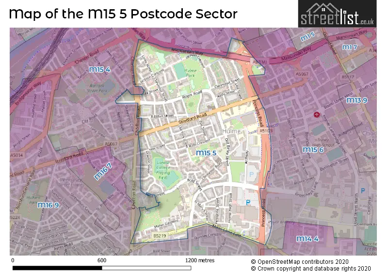
The M15 5 Postcode shares a border with M15 6 (MANCHESTER, Manchester Science Park), M15 4 (MANCHESTER) and M16 7 (MANCHESTER, Old Trafford, Moss Side).
The sector is within the post town of MANCHESTER.
M15 5 is a postcode sector within the M15 postcode district which is within the M Manchester postcode area.
The Royal Mail delivery office for the M15 5 postal sector is the South West (m) Delivery Office.
The area of the M15 5 postcode sector is 0.41 square miles which is 1.07 square kilometres or 264.73 square acres.

Map of the M15 5 Postcode Sector
Explore the M15 5 postcode sector by using our free interactive map.
| M | 1 | 5 | - | 5 | X | X |
| M | 1 | 5 | Space | 5 | Letter | Letter |
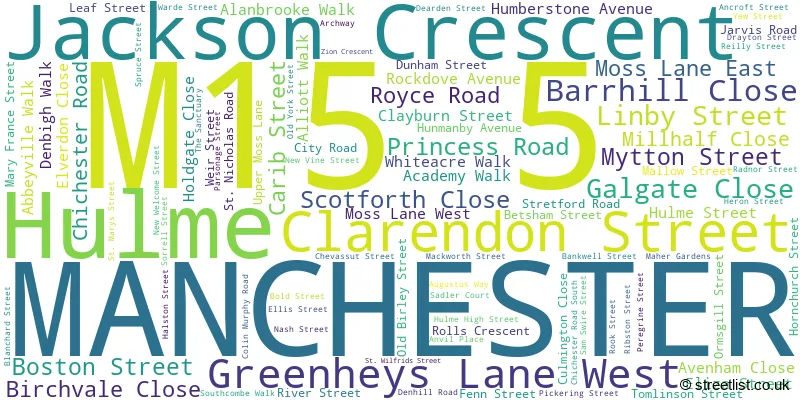
Official List of Streets
MANCHESTER (83 Streets)
Hulme (12 Streets)
Unofficial Streets or Alternative Spellings
MANCHESTER
BIRCHALL WAY BONSALL STREET CHORLTON ROAD GREENHEYS LANE LORDSMEAD STREET LOXFORD COURT MANCUNIAN WAY NEWBOLD WALK PEPPERHILL ROAD SHAWGREEN CLOSE WILLIAM KAY CLOSE ALMA COURT BRIAN REDHEAD COURT CLAYTON CLOSE CLOPTON WALK DAINTRY CLOSE DEANSGATE INTERCHANGE GEORGE PARR ROAD GLADSTONE COURT GLENHAM COURT MEDLOCK STREET MEDLOCK STREET JUNCTION MILLHALL CLOSE MOSS GROVE COURT NELSON COURT PHOENIX WAY RAWKIN CLOSE SHEARSBY CLOSE SORREL STREET TAMWORTH CLOSE TAMWORTH STREET WARWICK STREET WILBERFORCE CLOSE YORK STREETOld Trafford
CHESTER ROADWeather Forecast for M15 5
Press Button to Show Forecast for Manchester Youth Hostel
| Time Period | Icon | Description | Temperature | Rain Probability | Wind |
|---|---|---|---|---|---|
| 03:00 to 06:00 | Cloudy | 7.0°C (feels like 6.0°C) | 4.00% | N 4 mph | |
| 06:00 to 09:00 | Sunny day | 6.0°C (feels like 4.0°C) | 0.00% | NNE 7 mph | |
| 09:00 to 12:00 | Partly cloudy (day) | 8.0°C (feels like 6.0°C) | 0.00% | NNE 7 mph | |
| 12:00 to 15:00 | Cloudy | 10.0°C (feels like 9.0°C) | 3.00% | N 7 mph | |
| 15:00 to 18:00 | Partly cloudy (day) | 12.0°C (feels like 10.0°C) | 1.00% | NNW 7 mph | |
| 18:00 to 21:00 | Partly cloudy (day) | 10.0°C (feels like 8.0°C) | 1.00% | NW 9 mph | |
| 21:00 to 00:00 | Partly cloudy (night) | 8.0°C (feels like 6.0°C) | 1.00% | NW 7 mph |
Press Button to Show Forecast for Manchester Youth Hostel
| Time Period | Icon | Description | Temperature | Rain Probability | Wind |
|---|---|---|---|---|---|
| 00:00 to 03:00 | Cloudy | 6.0°C (feels like 5.0°C) | 4.00% | W 7 mph | |
| 03:00 to 06:00 | Cloudy | 6.0°C (feels like 4.0°C) | 5.00% | W 7 mph | |
| 06:00 to 09:00 | Overcast | 7.0°C (feels like 4.0°C) | 10.00% | WNW 7 mph | |
| 09:00 to 12:00 | Cloudy | 8.0°C (feels like 6.0°C) | 9.00% | NW 9 mph | |
| 12:00 to 15:00 | Cloudy | 10.0°C (feels like 8.0°C) | 10.00% | NW 9 mph | |
| 15:00 to 18:00 | Cloudy | 10.0°C (feels like 8.0°C) | 8.00% | NW 9 mph | |
| 18:00 to 21:00 | Cloudy | 9.0°C (feels like 8.0°C) | 7.00% | N 7 mph | |
| 21:00 to 00:00 | Partly cloudy (night) | 7.0°C (feels like 6.0°C) | 5.00% | ENE 4 mph |
Press Button to Show Forecast for Manchester Youth Hostel
| Time Period | Icon | Description | Temperature | Rain Probability | Wind |
|---|---|---|---|---|---|
| 00:00 to 03:00 | Cloudy | 6.0°C (feels like 4.0°C) | 7.00% | ENE 7 mph | |
| 03:00 to 06:00 | Cloudy | 5.0°C (feels like 3.0°C) | 10.00% | E 4 mph | |
| 06:00 to 09:00 | Overcast | 5.0°C (feels like 3.0°C) | 13.00% | E 7 mph | |
| 09:00 to 12:00 | Cloudy | 7.0°C (feels like 5.0°C) | 12.00% | ESE 7 mph | |
| 12:00 to 15:00 | Overcast | 9.0°C (feels like 8.0°C) | 16.00% | ESE 7 mph | |
| 15:00 to 18:00 | Overcast | 10.0°C (feels like 9.0°C) | 17.00% | ESE 7 mph | |
| 18:00 to 21:00 | Cloudy | 10.0°C (feels like 8.0°C) | 12.00% | E 7 mph | |
| 21:00 to 00:00 | Cloudy | 8.0°C (feels like 5.0°C) | 12.00% | ENE 9 mph |
Press Button to Show Forecast for Manchester Youth Hostel
| Time Period | Icon | Description | Temperature | Rain Probability | Wind |
|---|---|---|---|---|---|
| 00:00 to 03:00 | Overcast | 7.0°C (feels like 4.0°C) | 17.00% | E 7 mph | |
| 03:00 to 06:00 | Cloudy | 6.0°C (feels like 4.0°C) | 17.00% | E 7 mph | |
| 06:00 to 09:00 | Cloudy | 6.0°C (feels like 4.0°C) | 17.00% | ENE 7 mph | |
| 09:00 to 12:00 | Cloudy | 8.0°C (feels like 6.0°C) | 18.00% | E 9 mph | |
| 12:00 to 15:00 | Cloudy | 11.0°C (feels like 9.0°C) | 17.00% | ENE 9 mph | |
| 15:00 to 18:00 | Overcast | 12.0°C (feels like 9.0°C) | 47.00% | ENE 9 mph | |
| 18:00 to 21:00 | Cloudy | 11.0°C (feels like 9.0°C) | 14.00% | NE 9 mph | |
| 21:00 to 00:00 | Cloudy | 9.0°C (feels like 7.0°C) | 14.00% | NE 9 mph |
Schools and Places of Education Within the M15 5 Postcode Sector
Loreto College
Further education
Chichester Road, Manchester, , M15 5PB
Head: Mr Michael Jaffrain
Ofsted Rating: Outstanding
Inspection: 2022-12-16 (495 days ago)
Website: Visit Loreto College Website
Phone: 01612265156
Number of Pupils: 0
Rolls Crescent Primary School
Academy converter
Rolls Crescent, Manchester, , M15 5FT
Head: Mr J Reynolds and Ms H Turner
Ofsted Rating: Good
Inspection: 2022-01-13 (832 days ago)
Website: Visit Rolls Crescent Primary School Website
Phone: 01612099930
Number of Pupils: 424
St Wilfrid's RC Primary School
Voluntary aided school
Birchvale Close, Hulme, , M15 5BJ
Head: Mr R Moloney
Ofsted Rating: Good
Inspection: 2023-05-11 (349 days ago)
Website: Visit St Wilfrid's RC Primary School Website
Phone: 01612263339
Number of Pupils: 225
House Prices in the M15 5 Postcode Sector
| Type of Property | 2018 Average | 2018 Sales | 2017 Average | 2017 Sales | 2016 Average | 2016 Sales | 2015 Average | 2015 Sales |
|---|---|---|---|---|---|---|---|---|
| Detached | £197,225 | 4 | £185,625 | 4 | £166,440 | 5 | £182,000 | 1 |
| Semi-Detached | £185,217 | 9 | £156,646 | 12 | £163,945 | 11 | £151,600 | 5 |
| Terraced | £218,096 | 26 | £170,509 | 34 | £170,996 | 37 | £155,497 | 30 |
| Flats | £148,102 | 81 | £130,435 | 71 | £124,473 | 75 | £118,496 | 116 |
Important Postcodes M15 5 in the Postcode Sector
M15 5AN is the postcode for MAIN BUILDING, Castlefield Campus, Linby Street, and Castlefield Campus, Linby Street
M15 5BJ is the postcode for St. Wilfrids Catholic Primary School, Birchvale Close, and ST WILFRID'S RC PRIMARY SCHOOL, ST WILFRID'S STREET, HULME
M15 5DD is the postcode for Kath Locke Community Health And Resource Centre, 123 Moss Lane East
M15 5EF is the postcode for Proctor Youth Centre, Hulme Street
M15 5FS is the postcode for Hulme Resources Ltd, Claremont Centre, 2 Jarvis Road
M15 5FT is the postcode for MAIN BUILDING, Roll Crescent Primary School, Rolls Crescent, and Roll Crescent Primary School, Rolls Crescent
M15 5JB is the postcode for Alexandra Jobcentre, 91 Moss Lane East
M15 5NN is the postcode for Moss Side Leisure Centre, Moss Lane East
M15 5NR is the postcode for MAIN BUILDING, Greater Manchester Fire & Rescue Service, Moss Side Fire Station, 9 Denhill Road, and Greater Manchester Fire & Rescue Service, Moss Side Fire Station, 9 Denhill Road
M15 5NX is the postcode for Manchester City Council, Alexandra House, 2 Southcombe Walk, and Alexandra House, 2 Southcombe Walk, Moss Side
M15 5PB is the postcode for THE ELLIS & KENNEDY BUILDING, Loreto College, Chichester Road, WARD BUILDING, Loreto College, Chichester Road, SPORTS HALL, Loreto College, Chichester Road, Loreto College, Chichester Road, BALL BUILDING, Loreto College, Chichester Road, OUR LADY'S CHAPEL AND THE ART CENTRE, Loreto College, Chichester Road, and ST JOSEPH'S, Loreto College, Chichester Road
M15 5PE is the postcode for Greater Manchester Probation, 87 Moss Lane West, and National Probation Service, 87 Moss Lane West
M15 5RL is the postcode for Turing House, 5 Archway
M15 5RN is the postcode for One Manchester, Lovell House, Archway
M15 5TJ is the postcode for The Arch Medical Practice, Hulme Medical Centre, 175 Royce Road
M15 5ZA is the postcode for Manchester Education Dance Service, Zion Arts Centre, Stretford Road, and Zion Arts Centre, Z Arts
| The M15 5 Sector is within these Local Authorities |
|
|---|---|
| The M15 5 Sector is within these Counties |
|
| The M15 5 Sector is within these Water Company Areas |
|