The M16 0 postcode sector is within the county of Greater Manchester.
Did you know? According to the 2021 Census, the M16 0 postcode sector is home to a bustling 9,036 residents!
Given that each sector allows for 400 unique postcode combinations. Letters C, I, K, M, O and V are not allowed in the last two letters of a postcode. With 207 postcodes already in use, this leaves 193 units available.
The largest settlement in the M16 0 postal code is MANCHESTER followed by Old Trafford, and Firswood.
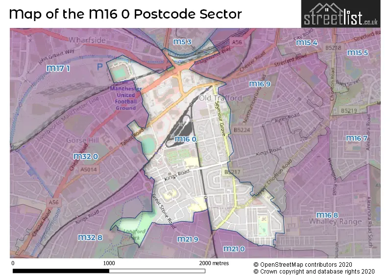
The M16 0 Postcode shares a border with M32 8 (Stretford), M50 3 (SALFORD), M16 8 (MANCHESTER, Whalley Range), M16 9 (MANCHESTER, Old Trafford), M5 3 (SALFORD), M17 1 (Trafford Park), M21 0 (MANCHESTER, Chorlton Cum Hardy), M21 9 (MANCHESTER, Chorlton Cum Hardy) and M32 0 (Stretford).
The sector is within the post town of MANCHESTER.
M16 0 is a postcode sector within the M16 postcode district which is within the M Manchester postcode area.
The Royal Mail delivery office for the M16 0 postal sector is the South West (m) Delivery Office.
The area of the M16 0 postcode sector is 0.72 square miles which is 1.87 square kilometres or 463.03 square acres.
Waterways within the M16 0 postcode sector include the Bridgewater Canal, Manchester Ship Canal.

Map of the M16 0 Postcode Sector
Explore the M16 0 postcode sector by using our free interactive map.
| M | 1 | 6 | - | 0 | X | X |
| M | 1 | 6 | Space | 0 | Letter | Letter |
Official List of Streets
MANCHESTER (68 Streets)
Old Trafford (10 Streets)
Unofficial Streets or Alternative Spellings
MANCHESTER
BRIDGEWATER WAY BUCKINGHAM ROAD CLARENDON ROAD WEST HUMPHREY ROAD KENSINGTON ROAD LYNWOOD AVENUE SEYMOUR PLACE WELLINGTON CRESCENTOld Trafford
CHESTER ROAD STANLEY ROADStretford
BARLOW ROAD GREAT STONE ROAD HORNBY ROAD RAILWAY ROADTrafford Park
SIR ALEX FERGUSON WAY TRAFFORD WHARF ROAD WHARF END WHARFSIDE WAYHulme
STRETFORD ROADChorlton Cum Hardy
MANCHESTER ROAD OSWALD ROAD ALPORT AVENUE BIRCH AVENUE BOTANICAL AVENUE BRIDGEWATER CANAL TOWPATH BROOKS ROAD HOTEL FOOTBALL STEPS WITH WHEELING RAMP JUBILEE COURT, SEYMOUR GROVE MUNICH TUNNEL NATELY ROAD PARK MEWS RIXTON COURT TALBOT PLACE TENNIS STREET THE FIRS THE QUADRANT TRENTHAM ROAD WHITE CITY CIRCLE WHITE CITY WAY WOBURN ROADSALFORD
TRAFFORD ROADWeather Forecast for M16 0
Press Button to Show Forecast for Old Trafford Lancashire C.C.C.
| Time Period | Icon | Description | Temperature | Rain Probability | Wind |
|---|---|---|---|---|---|
| 12:00 to 15:00 | Light rain | 8.0°C (feels like 6.0°C) | 48.00% | N 7 mph | |
| 15:00 to 18:00 | Cloudy | 9.0°C (feels like 8.0°C) | 34.00% | ENE 4 mph | |
| 18:00 to 21:00 | Light rain | 9.0°C (feels like 7.0°C) | 50.00% | NE 7 mph | |
| 21:00 to 00:00 | Cloudy | 7.0°C (feels like 5.0°C) | 7.00% | ENE 4 mph |
Press Button to Show Forecast for Old Trafford Lancashire C.C.C.
| Time Period | Icon | Description | Temperature | Rain Probability | Wind |
|---|---|---|---|---|---|
| 00:00 to 03:00 | Partly cloudy (night) | 5.0°C (feels like 3.0°C) | 2.00% | ENE 7 mph | |
| 03:00 to 06:00 | Partly cloudy (night) | 4.0°C (feels like 2.0°C) | 1.00% | ENE 4 mph | |
| 06:00 to 09:00 | Partly cloudy (day) | 3.0°C (feels like 2.0°C) | 1.00% | ENE 4 mph | |
| 09:00 to 12:00 | Partly cloudy (day) | 7.0°C (feels like 6.0°C) | 2.00% | E 4 mph | |
| 12:00 to 15:00 | Cloudy | 9.0°C (feels like 8.0°C) | 9.00% | ENE 4 mph | |
| 15:00 to 18:00 | Cloudy | 10.0°C (feels like 10.0°C) | 7.00% | E 4 mph | |
| 18:00 to 21:00 | Cloudy | 10.0°C (feels like 9.0°C) | 7.00% | NE 4 mph | |
| 21:00 to 00:00 | Partly cloudy (night) | 6.0°C (feels like 4.0°C) | 4.00% | ENE 7 mph |
Press Button to Show Forecast for Old Trafford Lancashire C.C.C.
| Time Period | Icon | Description | Temperature | Rain Probability | Wind |
|---|---|---|---|---|---|
| 00:00 to 03:00 | Partly cloudy (night) | 4.0°C (feels like 2.0°C) | 6.00% | ENE 4 mph | |
| 03:00 to 06:00 | Partly cloudy (night) | 3.0°C (feels like 1.0°C) | 6.00% | ENE 4 mph | |
| 06:00 to 09:00 | Partly cloudy (day) | 5.0°C (feels like 3.0°C) | 6.00% | ENE 4 mph | |
| 09:00 to 12:00 | Cloudy | 8.0°C (feels like 6.0°C) | 8.00% | E 7 mph | |
| 12:00 to 15:00 | Overcast | 10.0°C (feels like 9.0°C) | 16.00% | E 7 mph | |
| 15:00 to 18:00 | Cloudy | 11.0°C (feels like 9.0°C) | 18.00% | ENE 9 mph | |
| 18:00 to 21:00 | Cloudy | 10.0°C (feels like 8.0°C) | 15.00% | ENE 9 mph | |
| 21:00 to 00:00 | Cloudy | 7.0°C (feels like 5.0°C) | 17.00% | NE 9 mph |
Press Button to Show Forecast for Old Trafford Lancashire C.C.C.
| Time Period | Icon | Description | Temperature | Rain Probability | Wind |
|---|---|---|---|---|---|
| 00:00 to 03:00 | Cloudy | 6.0°C (feels like 4.0°C) | 16.00% | NE 9 mph | |
| 03:00 to 06:00 | Cloudy | 6.0°C (feels like 4.0°C) | 17.00% | NNE 9 mph | |
| 06:00 to 09:00 | Cloudy | 7.0°C (feels like 4.0°C) | 20.00% | NNE 9 mph | |
| 09:00 to 12:00 | Light rain | 8.0°C (feels like 5.0°C) | 50.00% | NNE 11 mph | |
| 12:00 to 15:00 | Heavy rain | 9.0°C (feels like 6.0°C) | 76.00% | N 11 mph | |
| 15:00 to 18:00 | Light rain | 10.0°C (feels like 7.0°C) | 57.00% | NNE 9 mph | |
| 18:00 to 21:00 | Cloudy | 10.0°C (feels like 8.0°C) | 18.00% | N 9 mph | |
| 21:00 to 00:00 | Partly cloudy (night) | 8.0°C (feels like 6.0°C) | 10.00% | NW 7 mph |
Schools and Places of Education Within the M16 0 Postcode Sector
Kings Road Primary School
Community school
Kings Road, Manchester, , M16 0GR
Head: Mr D Morgan
Ofsted Rating: Good
Inspection: 2023-06-28 (302 days ago)
Website: Visit Kings Road Primary School Website
Phone: 01618813571
Number of Pupils: 686
Manley Park Primary School
Community school
College Road, Manchester, , M16 0AA
Head: Miss Sarah-Jane Henderson
Ofsted Rating: Outstanding
Inspection: 2011-10-06 (4585 days ago)
Website: Visit Manley Park Primary School Website
Phone: 01618813808
Number of Pupils: 427
St John Vianney School
Non-maintained special school
Rye Bank Road, Manchester, , M16 0EX
Head: Mr Aidan Moloney
Ofsted Rating: Good
Inspection: 2023-02-22 (428 days ago)
Website: Visit St John Vianney School Website
Phone: 01618817843
Number of Pupils: 119
St Teresa's RC Primary School
Voluntary aided school
St Teresa's Road, Manchester, , M16 0GQ
Head: Mr Anthony Schilling
Ofsted Rating: Good
Inspection: 2023-07-19 (281 days ago)
Website: Visit St Teresa's RC Primary School Website
Phone: 01618813163
Number of Pupils: 170
House Prices in the M16 0 Postcode Sector
| Type of Property | 2018 Average | 2018 Sales | 2017 Average | 2017 Sales | 2016 Average | 2016 Sales | 2015 Average | 2015 Sales |
|---|---|---|---|---|---|---|---|---|
| Detached | £343,500 | 2 | £291,000 | 2 | £250,667 | 3 | £225,910 | 2 |
| Semi-Detached | £305,751 | 47 | £263,974 | 37 | £257,489 | 44 | £247,196 | 50 |
| Terraced | £228,731 | 16 | £210,712 | 18 | £198,771 | 23 | £181,018 | 26 |
| Flats | £154,749 | 139 | £136,845 | 60 | £126,836 | 87 | £134,548 | 16 |
Important Postcodes M16 0 in the Postcode Sector
M16 0AA is the postcode for JUNIOR SCHOOL, Manley Park Primary School, College Road
M16 0AS is the postcode for INFANT SCHOOL, Manley Park Primary School, York Avenue
M16 0DU is the postcode for Trafford Healthcare NHS Trust, Stretford Memorial Hospital
M16 0EX is the postcode for St. Hilda's C.E. Primary School, Warwick Road South, St. John Vianney Upper School - Rainbow Building, Rye Bank Road, Firswood, and St. John Vianney Upper School, Rye Bank Road
M16 0GQ is the postcode for St Teresa's Primary School, St Teresa's Road, and St. Teresas RC Primary School, St. Teresas Road
M16 0GR is the postcode for Kings Road Primary School, Kings Road, and KINGS ROAD PRIMARY SCHOOL, KINGS ROAD, STRETFORD
M16 0LW is the postcode for Seymour Grove Health Centre, 70 Seymour Grove, and 70, Seymour Grove
M16 0RB is the postcode for Grove House, Skerton Road, and HSE - FIRST, SECOND, THIRD FLOOR, Grove House, Skerton Road
M16 0RE is the postcode for Greater Manchester Police
M16 0SH is the postcode for St HildaG��s C of E Primary School, Warwick Road South, Firswood
| The M16 0 Sector is within these Local Authorities |
|
|---|---|
| The M16 0 Sector is within these Counties |
|
| The M16 0 Sector is within these Water Company Areas |
|
Tourist Attractions within the M16 0 Postcode Area
We found 1 visitor attractions within the M16 postcode area
| Manchester United Museum & Tour Centre |
|---|
| Museums & Art Galleries |
| Museum and / or Art Gallery |
| View Manchester United Museum & Tour Centre on Google Maps |