The M16 8 postcode sector is within the county of Greater Manchester.
Did you know? According to the 2021 Census, the M16 8 postcode sector is home to a bustling 11,253 residents!
Given that each sector allows for 400 unique postcode combinations. Letters C, I, K, M, O and V are not allowed in the last two letters of a postcode. With 222 postcodes already in use, this leaves 178 units available.
The largest settlements in the M16 8 postal code are MANCHESTER and Whalley Range.
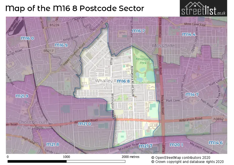
The M16 8 Postcode shares a border with M16 0 (MANCHESTER, Old Trafford, Firswood), M21 7 (MANCHESTER, Chorlton Cum Hardy), M14 7 (MANCHESTER, Rusholme, Fallowfield), M16 7 (MANCHESTER, Old Trafford, Moss Side), M16 9 (MANCHESTER, Old Trafford) and M21 0 (MANCHESTER, Chorlton Cum Hardy).
The sector is within the post town of MANCHESTER.
M16 8 is a postcode sector within the M16 postcode district which is within the M Manchester postcode area.
The Royal Mail delivery office for the M16 8 postal sector is the South West (m) Delivery Office.
The area of the M16 8 postcode sector is 0.65 square miles which is 1.69 square kilometres or 418.07 square acres.

Map of the M16 8 Postcode Sector
Explore the M16 8 postcode sector by using our free interactive map.
| M | 1 | 6 | - | 8 | X | X |
| M | 1 | 6 | Space | 8 | Letter | Letter |
Official List of Streets
MANCHESTER (75 Streets)
Unofficial Streets or Alternative Spellings
Weather Forecast for M16 8
Press Button to Show Forecast for Whalley Range
| Time Period | Icon | Description | Temperature | Rain Probability | Wind |
|---|---|---|---|---|---|
| 15:00 to 18:00 | Heavy rain | 8.0°C (feels like 5.0°C) | 86.00% | WSW 11 mph | |
| 18:00 to 21:00 | Heavy rain | 9.0°C (feels like 6.0°C) | 83.00% | WSW 11 mph | |
| 21:00 to 00:00 | Light rain | 9.0°C (feels like 7.0°C) | 58.00% | W 13 mph |
Press Button to Show Forecast for Whalley Range
| Time Period | Icon | Description | Temperature | Rain Probability | Wind |
|---|---|---|---|---|---|
| 00:00 to 03:00 | Light rain | 9.0°C (feels like 6.0°C) | 57.00% | WNW 13 mph | |
| 03:00 to 06:00 | Light rain | 9.0°C (feels like 6.0°C) | 55.00% | WNW 13 mph | |
| 06:00 to 09:00 | Cloudy | 8.0°C (feels like 5.0°C) | 29.00% | NW 13 mph | |
| 09:00 to 12:00 | Cloudy | 10.0°C (feels like 7.0°C) | 55.00% | NW 16 mph | |
| 12:00 to 15:00 | Cloudy | 11.0°C (feels like 8.0°C) | 38.00% | NW 13 mph | |
| 15:00 to 18:00 | Light rain shower (day) | 11.0°C (feels like 9.0°C) | 42.00% | NNW 13 mph | |
| 18:00 to 21:00 | Cloudy | 10.0°C (feels like 8.0°C) | 5.00% | N 11 mph | |
| 21:00 to 00:00 | Partly cloudy (night) | 8.0°C (feels like 6.0°C) | 1.00% | NE 7 mph |
Press Button to Show Forecast for Whalley Range
| Time Period | Icon | Description | Temperature | Rain Probability | Wind |
|---|---|---|---|---|---|
| 00:00 to 03:00 | Partly cloudy (night) | 6.0°C (feels like 5.0°C) | 1.00% | NE 4 mph | |
| 03:00 to 06:00 | Clear night | 5.0°C (feels like 3.0°C) | 1.00% | N 4 mph | |
| 06:00 to 09:00 | Sunny day | 4.0°C (feels like 3.0°C) | 1.00% | N 4 mph | |
| 09:00 to 12:00 | Sunny day | 8.0°C (feels like 6.0°C) | 1.00% | N 4 mph | |
| 12:00 to 15:00 | Cloudy | 10.0°C (feels like 9.0°C) | 5.00% | N 7 mph | |
| 15:00 to 18:00 | Cloudy | 12.0°C (feels like 10.0°C) | 6.00% | NNW 7 mph | |
| 18:00 to 21:00 | Partly cloudy (day) | 11.0°C (feels like 9.0°C) | 1.00% | NNW 7 mph | |
| 21:00 to 00:00 | Clear night | 8.0°C (feels like 7.0°C) | 1.00% | N 4 mph |
Press Button to Show Forecast for Whalley Range
| Time Period | Icon | Description | Temperature | Rain Probability | Wind |
|---|---|---|---|---|---|
| 00:00 to 03:00 | Partly cloudy (night) | 7.0°C (feels like 6.0°C) | 2.00% | N 2 mph | |
| 03:00 to 06:00 | Cloudy | 6.0°C (feels like 5.0°C) | 5.00% | N 2 mph | |
| 06:00 to 09:00 | Overcast | 7.0°C (feels like 6.0°C) | 8.00% | NW 2 mph | |
| 09:00 to 12:00 | Cloudy | 9.0°C (feels like 8.0°C) | 15.00% | N 2 mph | |
| 12:00 to 15:00 | Light rain | 11.0°C (feels like 10.0°C) | 49.00% | NE 7 mph | |
| 15:00 to 18:00 | Cloudy | 12.0°C (feels like 11.0°C) | 15.00% | NE 7 mph | |
| 18:00 to 21:00 | Cloudy | 11.0°C (feels like 10.0°C) | 6.00% | NE 7 mph | |
| 21:00 to 00:00 | Cloudy | 9.0°C (feels like 8.0°C) | 5.00% | NE 7 mph |
Press Button to Show Forecast for Whalley Range
| Time Period | Icon | Description | Temperature | Rain Probability | Wind |
|---|---|---|---|---|---|
| 00:00 to 03:00 | Partly cloudy (night) | 7.0°C (feels like 6.0°C) | 3.00% | ENE 4 mph | |
| 03:00 to 06:00 | Overcast | 7.0°C (feels like 5.0°C) | 9.00% | E 4 mph | |
| 06:00 to 09:00 | Cloudy | 7.0°C (feels like 5.0°C) | 7.00% | E 4 mph | |
| 09:00 to 12:00 | Cloudy | 9.0°C (feels like 7.0°C) | 7.00% | ENE 7 mph | |
| 12:00 to 15:00 | Cloudy | 10.0°C (feels like 9.0°C) | 7.00% | ENE 7 mph | |
| 15:00 to 18:00 | Cloudy | 11.0°C (feels like 10.0°C) | 15.00% | NE 7 mph | |
| 18:00 to 21:00 | Cloudy | 11.0°C (feels like 9.0°C) | 8.00% | NE 7 mph | |
| 21:00 to 00:00 | Partly cloudy (night) | 9.0°C (feels like 7.0°C) | 4.00% | NE 7 mph |
Schools and Places of Education Within the M16 8 Postcode Sector
IncludEd Learning
Other independent special school
8 Alexandra Road South, Manchester, , M16 8ER
Head: Ms noreen khan
Ofsted Rating: Good
Inspection: 2020-01-16 (1554 days ago)
Website: Visit IncludEd Learning Website
Phone: 07380292211
Number of Pupils: 12
Our Lady's RC Primary School Manchester
Voluntary aided school
Whalley Road, Manchester, , M16 8AW
Head: Mrs Catherine Gordon
Ofsted Rating: Good
Inspection: 2019-06-12 (1772 days ago)
Website: Visit Our Lady's RC Primary School Manchester Website
Phone: 01612262767
Number of Pupils: 215
St Margaret's CofE Primary School
Voluntary controlled school
Withington Road, Manchester, , M16 8FQ
Head: Mr David Hunter
Ofsted Rating: Good
Inspection: 2023-06-21 (302 days ago)
Website: Visit St Margaret's CofE Primary School Website
Phone: 01612262271
Number of Pupils: 643
Whalley Range 11-18 High School
Academy converter
Wilbraham Road, Manchester, Greater Manchester, M16 8GW
Head: Ms Jacqueline Fahey
Ofsted Rating: Good
Inspection: 2022-04-28 (721 days ago)
Website: Visit Whalley Range 11-18 High School Website
Phone: 01618619727
Number of Pupils: 1667
William Hulme's Grammar School
Academy sponsor led
Spring Bridge Road, Manchester, , M16 8PR
Head: Mrs Kate Heaton
Ofsted Rating: Good
Inspection: 2019-05-15 (1800 days ago)
Website: Visit William Hulme's Grammar School Website
Phone: 01612262054
Number of Pupils: 1595
House Prices in the M16 8 Postcode Sector
| Type of Property | 2018 Average | 2018 Sales | 2017 Average | 2017 Sales | 2016 Average | 2016 Sales | 2015 Average | 2015 Sales |
|---|---|---|---|---|---|---|---|---|
| Detached | £647,500 | 2 | £398,611 | 9 | £342,208 | 12 | £393,778 | 9 |
| Semi-Detached | £312,154 | 34 | £315,035 | 38 | £278,954 | 36 | £275,924 | 33 |
| Terraced | £228,177 | 22 | £313,464 | 35 | £225,102 | 31 | £231,051 | 26 |
| Flats | £132,424 | 51 | £125,492 | 65 | £118,174 | 105 | £105,678 | 119 |
Important Postcodes M16 8 in the Postcode Sector
M16 8AW is the postcode for MAIN BUILDING, Our Ladys RC Primary School, Whalley Road
M16 8EE is the postcode for The Range Medical Centre, Withington Road
M16 8FQ is the postcode for St. Margarets C of E Primary School, Withington Road
M16 8GW is the postcode for MAIN BUILDING, A,B,C,D,E, Whalley Range High School for Girls, Wilbraham Road, Whalley Range High School for Girls, Wilbraham Road, Whalley Range Sports Complex, Whalley Range High School, Wilbraham Road, and BLOCK G, Whalley Range High School for Girls, Wilbraham Road
M16 8HX is the postcode for VAUGHAN BUILDING AND LINKED BUILDINGS, St. Bedes College, Alexandra Road South, HENSHAW BUILDING, St. Bedes College, Alexandra Road South, and REGIS BUILDING, St. Bedes College, Alexandra Road South
M16 8JN is the postcode for 172-174, Withington Road
M16 8PR is the postcode for William Hulmes Grammar School, Springbridge Road, SPORTS HALL, William Hulmes Grammar School, Springbridge Road, DONNER BUILDING, William Hulmes Grammar School, Springbridge Road, ZOCHONIS, William Hulmes Grammar School, Springbridge Road, PRIMARY SCHOOL BUILDING, William Hulmes Grammar School, Springbridge Road, SCIENCE BUILDING, William Hulmes Grammar School, Springbridge Road, FIELD CHANGING ROOMS, William Hulmes Grammar School, Springbridge Road, PERFORMING ARTS CENTRE (PAC), William Hulmes Grammar School, Springbridge Road, LEARNING RESOURCE CENTRE (LRC), William Hulmes Grammar School, Springbridge Road, and MAIN BUILDING, William Hulmes Grammar School, Springbridge Road
| The M16 8 Sector is within these Local Authorities |
|
|---|---|
| The M16 8 Sector is within these Counties |
|
| The M16 8 Sector is within these Water Company Areas |
|