The M22 9 postcode sector is within the county of Greater Manchester.
Did you know? According to the 2021 Census, the M22 9 postcode sector is home to a bustling 9,863 residents!
Given that each sector allows for 400 unique postcode combinations. Letters C, I, K, M, O and V are not allowed in the last two letters of a postcode. With 220 postcodes already in use, this leaves 180 units available.
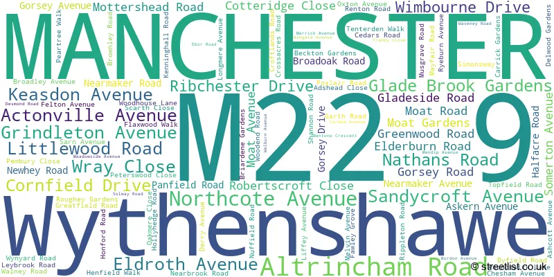
The largest settlements in the M22 9 postal code are MANCHESTER and Wythenshawe.
The M22 9 Postcode shares a border with M22 4 (MANCHESTER, Sharston Industrial Area, Northenden), M22 5 (MANCHESTER, Wythenshawe), M22 1 (MANCHESTER, Wythenshawe), M22 8 (MANCHESTER, Wythenshawe) and M23 2 (MANCHESTER).
The sector is within the post town of MANCHESTER.
M22 9 is a postcode sector within the M22 postcode district which is within the M Manchester postcode area.
The Royal Mail delivery office for the M22 9 postal sector is the Wythenshawe Delivery Office.
The area of the M22 9 postcode sector is 0.54 square miles which is 1.39 square kilometres or 343.43 square acres.
The M22 9 postcode sector is crossed by the M56 motorway.

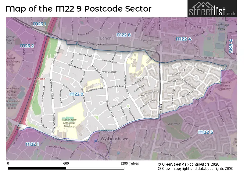
Map of the M22 9 Postcode Sector
Explore the M22 9 postcode sector by using our free interactive map.
| M | 2 | 2 | - | 9 | X | X |
| M | 2 | 2 | Space | 9 | Letter | Letter |
Official List of Streets
Wythenshawe (8 Streets)
MANCHESTER (92 Streets)
Unofficial Streets or Alternative Spellings
MANCHESTER
ACRES FOLD AVENUE PORTWAY RENTON ROADWythenshawe
GREENWOOD ROADGatley
HOLLYHEDGE ROAD GARRICK GARDENSWeather Forecast for M22 9
Press Button to Show Forecast for Wythenshawe
| Time Period | Icon | Description | Temperature | Rain Probability | Wind |
|---|---|---|---|---|---|
| 12:00 to 15:00 | Light rain | 8.0°C (feels like 6.0°C) | 49.00% | N 7 mph | |
| 15:00 to 18:00 | Cloudy | 9.0°C (feels like 7.0°C) | 9.00% | ENE 4 mph | |
| 18:00 to 21:00 | Light rain | 9.0°C (feels like 7.0°C) | 52.00% | NNE 4 mph | |
| 21:00 to 00:00 | Cloudy | 6.0°C (feels like 5.0°C) | 43.00% | NE 4 mph |
Press Button to Show Forecast for Wythenshawe
| Time Period | Icon | Description | Temperature | Rain Probability | Wind |
|---|---|---|---|---|---|
| 00:00 to 03:00 | Partly cloudy (night) | 5.0°C (feels like 2.0°C) | 2.00% | E 7 mph | |
| 03:00 to 06:00 | Partly cloudy (night) | 3.0°C (feels like 1.0°C) | 2.00% | ENE 4 mph | |
| 06:00 to 09:00 | Sunny day | 3.0°C (feels like 1.0°C) | 1.00% | ENE 4 mph | |
| 09:00 to 12:00 | Partly cloudy (day) | 7.0°C (feels like 6.0°C) | 2.00% | NE 4 mph | |
| 12:00 to 15:00 | Overcast | 9.0°C (feels like 8.0°C) | 9.00% | E 4 mph | |
| 15:00 to 18:00 | Cloudy | 10.0°C (feels like 9.0°C) | 6.00% | E 4 mph | |
| 18:00 to 21:00 | Cloudy | 9.0°C (feels like 8.0°C) | 6.00% | NE 4 mph | |
| 21:00 to 00:00 | Partly cloudy (night) | 6.0°C (feels like 4.0°C) | 4.00% | ENE 7 mph |
Press Button to Show Forecast for Wythenshawe
| Time Period | Icon | Description | Temperature | Rain Probability | Wind |
|---|---|---|---|---|---|
| 00:00 to 03:00 | Partly cloudy (night) | 4.0°C (feels like 2.0°C) | 6.00% | ENE 4 mph | |
| 03:00 to 06:00 | Partly cloudy (night) | 3.0°C (feels like 1.0°C) | 7.00% | ENE 4 mph | |
| 06:00 to 09:00 | Cloudy | 4.0°C (feels like 2.0°C) | 9.00% | ENE 4 mph | |
| 09:00 to 12:00 | Partly cloudy (day) | 8.0°C (feels like 6.0°C) | 4.00% | E 7 mph | |
| 12:00 to 15:00 | Overcast | 10.0°C (feels like 8.0°C) | 16.00% | E 7 mph | |
| 15:00 to 18:00 | Light rain | 10.0°C (feels like 8.0°C) | 45.00% | E 9 mph | |
| 18:00 to 21:00 | Cloudy | 10.0°C (feels like 8.0°C) | 15.00% | ENE 9 mph | |
| 21:00 to 00:00 | Cloudy | 7.0°C (feels like 5.0°C) | 14.00% | NE 9 mph |
Press Button to Show Forecast for Wythenshawe
| Time Period | Icon | Description | Temperature | Rain Probability | Wind |
|---|---|---|---|---|---|
| 00:00 to 03:00 | Cloudy | 6.0°C (feels like 3.0°C) | 15.00% | NE 9 mph | |
| 03:00 to 06:00 | Cloudy | 6.0°C (feels like 3.0°C) | 18.00% | NE 9 mph | |
| 06:00 to 09:00 | Light rain | 7.0°C (feels like 4.0°C) | 49.00% | NNE 9 mph | |
| 09:00 to 12:00 | Light rain | 8.0°C (feels like 5.0°C) | 50.00% | NNE 11 mph | |
| 12:00 to 15:00 | Heavy rain | 9.0°C (feels like 6.0°C) | 77.00% | NNE 11 mph | |
| 15:00 to 18:00 | Heavy rain | 10.0°C (feels like 7.0°C) | 76.00% | NNE 9 mph | |
| 18:00 to 21:00 | Light rain shower (day) | 10.0°C (feels like 8.0°C) | 37.00% | NNE 9 mph | |
| 21:00 to 00:00 | Partly cloudy (night) | 7.0°C (feels like 6.0°C) | 12.00% | NNW 7 mph |
Schools and Places of Education Within the M22 9 Postcode Sector
Haveley Hey Community School
Academy sponsor led
Nearbrook Road, Manchester, , M22 9NS
Head: Mrs Susan Spiteri
Ofsted Rating: Good
Inspection: 2019-03-27 (1856 days ago)
Website: Visit Haveley Hey Community School Website
Phone: 01614989508
Number of Pupils: 476
Manchester Enterprise Academy
Academy sponsor led
Simonsway, Wythenshawe, Greater Manchester, M22 9RH
Head: Mrs Kyra Jones
Ofsted Rating: Good
Inspection: 2021-09-22 (946 days ago)
Website: Visit Manchester Enterprise Academy Website
Phone: 01614992726
Number of Pupils: 1274
Ss John Fisher and Thomas More Catholic Primary School
Academy converter
Woodhouse Lane, Manchester, Greater Manchester, M22 9NW
Head: Mr Dominic Hemington
Ofsted Rating: Good
Inspection: 2023-06-14 (316 days ago)
Website: Visit Ss John Fisher and Thomas More Catholic Primary School Website
Phone: 01619983422
Number of Pupils: 381
House Prices in the M22 9 Postcode Sector
| Type of Property | 2018 Average | 2018 Sales | 2017 Average | 2017 Sales | 2016 Average | 2016 Sales | 2015 Average | 2015 Sales |
|---|---|---|---|---|---|---|---|---|
| Detached | £263,750 | 2 | £244,975 | 2 | £245,166 | 3 | £224,167 | 3 |
| Semi-Detached | £123,079 | 12 | £126,147 | 17 | £114,416 | 24 | £108,167 | 23 |
| Terraced | £141,464 | 14 | £128,932 | 22 | £121,171 | 26 | £99,805 | 29 |
| Flats | £98,395 | 10 | £98,056 | 8 | £93,167 | 3 | £83,790 | 5 |
Important Postcodes M22 9 in the Postcode Sector
M22 9AA is the postcode for Royal Mail, Wythenshawe Delivery Office, Altrincham Road
M22 9HD is the postcode for 307 GREENWOOD ROAD, MANCHESTER, and 307 Greenwood Road
M22 9NS is the postcode for Haveley Hey Community School, Nearbrook Road
M22 9NW is the postcode for St John Fisher And St Thomas More Primary School, Woodhouse Lane, Benchill, and St. John Fisher & Thomas More Primary School, Woodhouse Lane
M22 9PQ is the postcode for Greater Manchester Police, Poundswick Lane, and Transport for Greater Manchester, Wythenshawe Interchange, 31 Poundswick Lane
M22 9RH is the postcode for Manchester Enterprise Academy, Simonsway
M22 9TA is the postcode for WILLOW PARK HOUSE, 8 POUNDSWICK LANE, MANCHESTER, Sharston Surestart Centre, Poundswick Lane, and Wythenshawe House, 8 Poundswick Lane
M22 9TG is the postcode for MAIN BLOCK (C,D,E&F), The Manchester College, Wythenshawe Campus, The Manchester College, Wythenshawe Campus, BLOCK A, The Manchester College, Wythenshawe Campus, and BLOCK B, The Manchester College, Wythenshawe Campus
M22 9WP is the postcode for St John Fisher & Thomas More Catholic Primary School, Woodhouse Lane
| The M22 9 Sector is within these Local Authorities |
|
|---|---|
| The M22 9 Sector is within these Counties |
|
| The M22 9 Sector is within these Water Company Areas |
|