The M25 0 postcode sector is within the county of Greater Manchester.
Did you know? According to the 2021 Census, the M25 0 postcode sector is home to a bustling 9,502 residents!
Given that each sector allows for 400 unique postcode combinations. Letters C, I, K, M, O and V are not allowed in the last two letters of a postcode. With 181 postcodes already in use, this leaves 219 units available.
The M25 0 postal code covers the settlement of Prestwich.
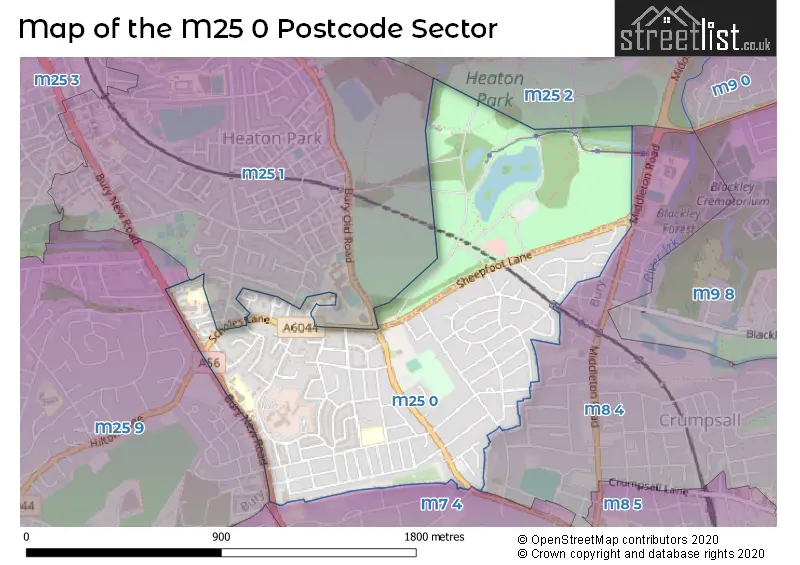
The M25 0 Postcode shares a border with M7 4 (SALFORD), M8 4 (MANCHESTER, Crumpsall), M25 9 (Prestwich), M25 1 (Prestwich) and M25 2 (Prestwich).
The sector is within the post town of MANCHESTER.
M25 0 is a postcode sector within the M25 postcode district which is within the M Manchester postcode area.
The Royal Mail delivery office for the M25 0 postal sector is the Prestwich Delivery Office.
The area of the M25 0 postcode sector is 0.74 square miles which is 1.93 square kilometres or 476.16 square acres.

Map of the M25 0 Postcode Sector
Explore the M25 0 postcode sector by using our free interactive map.
| M | 2 | 5 | - | 0 | X | X |
| M | 2 | 5 | Space | 0 | Letter | Letter |
Official List of Streets
Prestwich (91 Streets)
Unofficial Streets or Alternative Spellings
Prestwich
BUCKINGHAM ROAD GEORGE STREET HILTON LANE HOPE PARK ROAD OSTRICH LANE THORNDYKE WALKMANCHESTER
HILLWOOD AVENUE NEWINGTON AVENUE NORTHBROOK AVENUECrumpsall
BROOKLANDS ROADMiddleton
MIDDLETON ROAD BEECHCROFT THE MEWS THE RESIDENCESWeather Forecast for M25 0
Press Button to Show Forecast for Heaton Hall
| Time Period | Icon | Description | Temperature | Rain Probability | Wind |
|---|---|---|---|---|---|
| 09:00 to 12:00 | Overcast | 8.0°C (feels like 5.0°C) | 12.00% | NW 9 mph | |
| 12:00 to 15:00 | Light rain | 8.0°C (feels like 6.0°C) | 50.00% | NE 4 mph | |
| 15:00 to 18:00 | Cloudy | 9.0°C (feels like 8.0°C) | 9.00% | N 4 mph | |
| 18:00 to 21:00 | Cloudy | 8.0°C (feels like 6.0°C) | 8.00% | ENE 7 mph | |
| 21:00 to 00:00 | Cloudy | 6.0°C (feels like 4.0°C) | 8.00% | ENE 7 mph |
Press Button to Show Forecast for Heaton Hall
| Time Period | Icon | Description | Temperature | Rain Probability | Wind |
|---|---|---|---|---|---|
| 00:00 to 03:00 | Partly cloudy (night) | 4.0°C (feels like 2.0°C) | 2.00% | ENE 7 mph | |
| 03:00 to 06:00 | Clear night | 2.0°C (feels like 0.0°C) | 1.00% | NE 4 mph | |
| 06:00 to 09:00 | Sunny day | 3.0°C (feels like 1.0°C) | 1.00% | NE 4 mph | |
| 09:00 to 12:00 | Cloudy | 7.0°C (feels like 5.0°C) | 5.00% | E 4 mph | |
| 12:00 to 15:00 | Overcast | 9.0°C (feels like 8.0°C) | 9.00% | ENE 4 mph | |
| 15:00 to 18:00 | Cloudy | 10.0°C (feels like 9.0°C) | 6.00% | ENE 4 mph | |
| 18:00 to 21:00 | Cloudy | 9.0°C (feels like 8.0°C) | 6.00% | NE 4 mph | |
| 21:00 to 00:00 | Partly cloudy (night) | 6.0°C (feels like 4.0°C) | 3.00% | ENE 7 mph |
Press Button to Show Forecast for Heaton Hall
| Time Period | Icon | Description | Temperature | Rain Probability | Wind |
|---|---|---|---|---|---|
| 00:00 to 03:00 | Clear night | 4.0°C (feels like 2.0°C) | 5.00% | ENE 4 mph | |
| 03:00 to 06:00 | Partly cloudy (night) | 3.0°C (feels like 1.0°C) | 5.00% | ENE 4 mph | |
| 06:00 to 09:00 | Partly cloudy (day) | 4.0°C (feels like 2.0°C) | 5.00% | ENE 4 mph | |
| 09:00 to 12:00 | Partly cloudy (day) | 8.0°C (feels like 6.0°C) | 5.00% | E 7 mph | |
| 12:00 to 15:00 | Overcast | 10.0°C (feels like 8.0°C) | 14.00% | E 9 mph | |
| 15:00 to 18:00 | Cloudy | 10.0°C (feels like 8.0°C) | 17.00% | E 9 mph | |
| 18:00 to 21:00 | Cloudy | 9.0°C (feels like 7.0°C) | 15.00% | ENE 9 mph | |
| 21:00 to 00:00 | Cloudy | 7.0°C (feels like 4.0°C) | 15.00% | ENE 9 mph |
Press Button to Show Forecast for Heaton Hall
| Time Period | Icon | Description | Temperature | Rain Probability | Wind |
|---|---|---|---|---|---|
| 00:00 to 03:00 | Cloudy | 6.0°C (feels like 3.0°C) | 13.00% | NE 9 mph | |
| 03:00 to 06:00 | Cloudy | 6.0°C (feels like 3.0°C) | 15.00% | NE 9 mph | |
| 06:00 to 09:00 | Light rain | 7.0°C (feels like 4.0°C) | 48.00% | NE 9 mph | |
| 09:00 to 12:00 | Light rain | 8.0°C (feels like 5.0°C) | 49.00% | NNE 11 mph | |
| 12:00 to 15:00 | Heavy rain | 9.0°C (feels like 6.0°C) | 78.00% | NNE 11 mph | |
| 15:00 to 18:00 | Heavy rain | 9.0°C (feels like 7.0°C) | 77.00% | N 9 mph | |
| 18:00 to 21:00 | Light rain shower (day) | 10.0°C (feels like 8.0°C) | 39.00% | NNW 9 mph | |
| 21:00 to 00:00 | Partly cloudy (night) | 8.0°C (feels like 6.0°C) | 12.00% | NNW 7 mph |
Schools and Places of Education Within the M25 0 Postcode Sector
Manchester Mesivta School
Voluntary aided school
Beechwood, Prestwich, Greater Manchester, M25 0PH
Head: Rabbi Aryeh Katz
Ofsted Rating: Requires improvement
Inspection: 2022-05-05 (721 days ago)
Website: Visit Manchester Mesivta School Website
Phone: 01617731789
Number of Pupils: 229
Sedgley Park Community Primary School
Community school
Kings Road, Manchester, , M25 0HT
Head: Mrs Helen Forrester
Ofsted Rating: Good
Inspection: 2018-09-19 (2045 days ago)
Website: Visit Sedgley Park Community Primary School Website
Phone: 01617733146
Number of Pupils: 305
Yesoiday Hatorah Boys Academy
Academy converter
Sedgley Park Road, Manchester, Lancashire, M25 0JW
Head: Rabbi Jonathan Yodaiken
Ofsted Rating: Good
Inspection: 2023-05-11 (350 days ago)
Website: Visit Yesoiday Hatorah Boys Academy Website
Phone: 01617736364
Number of Pupils: 447
House Prices in the M25 0 Postcode Sector
| Type of Property | 2018 Average | 2018 Sales | 2017 Average | 2017 Sales | 2016 Average | 2016 Sales | 2015 Average | 2015 Sales |
|---|---|---|---|---|---|---|---|---|
| Detached | £435,842 | 19 | £404,773 | 22 | £351,129 | 19 | £308,115 | 19 |
| Semi-Detached | £255,654 | 71 | £237,373 | 86 | £219,106 | 93 | £203,588 | 90 |
| Terraced | £191,377 | 13 | £229,994 | 9 | £214,125 | 12 | £187,071 | 7 |
| Flats | £173,700 | 5 | £247,571 | 7 | £225,245 | 6 | £103,071 | 7 |
Important Postcodes M25 0 in the Postcode Sector
M25 0HT is the postcode for Sedgley Park Cp School, Bishops Road, Prestwich, Sedgley Park Community Primary School, Bishops Road, Prestwich, and Sedgley Park Cp School, Bishops Road
M25 0JT is the postcode for Greater Manchester Police, Sedgley Park Training School, Sedgley Park Road, Prestwich, and Greater Manchester Police, Sedgley Park Training School, Sedgley Park Road
M25 0JW is the postcode for BLOCK A, Yesoiday HaTorah School, Sedgley Park Road, BLOCK A, Yesoiday Hatorah Multi Academy Trust, Sedgley Park Road, BLOCKS C,D & E, Yesoiday Hatorah Multi Academy Trust, Sedgley Park Road, PORTACABINS, Yesoiday Hatorah Multi Academy Trust, Sedgley Park Road, KINDERGARTEN, Yesoiday Hatorah Multi Academy Trust, Sedgley Park Road, BLOCK B, Yesoiday HaTorah School, Sedgley Park Road, and BLOCKS C,D & E, Yesoiday HaTorah School, Sedgley Park Road
M25 0PH is the postcode for Manchester Mesivta School, Charlton Avenue, and Manchester Mesivta School, Charlton Avenue, Prestwich
| The M25 0 Sector is within these Local Authorities |
|
|---|---|
| The M25 0 Sector is within these Counties |
|
| The M25 0 Sector is within these Water Company Areas |
|
Tourist Attractions within the M25 0 Postcode Area
We found 1 visitor attractions within the M25 postcode area
| Heaton Park Tramway |
|---|
| Railways |
| Steam / Heritage Railway |
| View Heaton Park Tramway on Google Maps |