The M25 1 postcode sector is within the county of Greater Manchester.
Did you know? According to the 2021 Census, the M25 1 postcode sector is home to a bustling 7,812 residents!
Given that each sector allows for 400 unique postcode combinations. Letters C, I, K, M, O and V are not allowed in the last two letters of a postcode. With 213 postcodes already in use, this leaves 187 units available.
The M25 1 postal code covers the settlement of Prestwich.
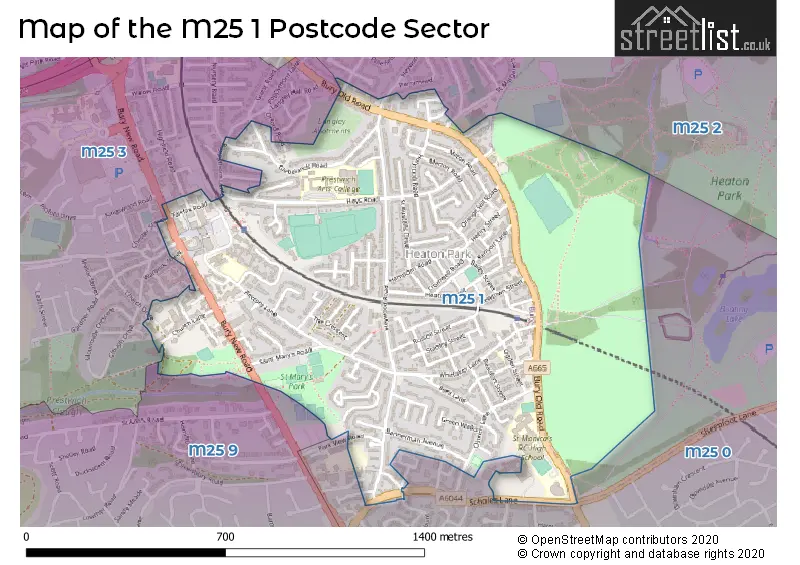
The M25 1 Postcode shares a border with M25 0 (Prestwich), M25 3 (Prestwich), M25 9 (Prestwich) and M25 2 (Prestwich).
The sector is within the post town of MANCHESTER.
M25 1 is a postcode sector within the M25 postcode district which is within the M Manchester postcode area.
The Royal Mail delivery office for the M25 1 postal sector is the Prestwich Delivery Office.
The area of the M25 1 postcode sector is 0.71 square miles which is 1.83 square kilometres or 453.41 square acres.

Map of the M25 1 Postcode Sector
Explore the M25 1 postcode sector by using our free interactive map.
| M | 2 | 5 | - | 1 | X | X |
| M | 2 | 5 | Space | 1 | Letter | Letter |
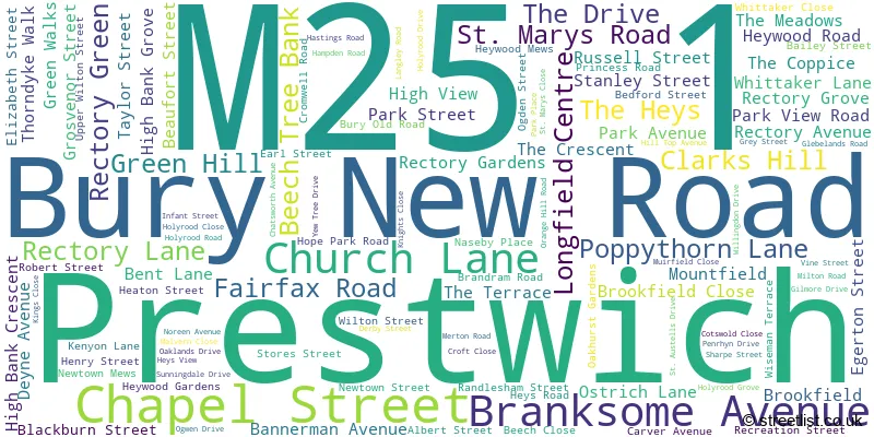
Official List of Streets
Prestwich (113 Streets)
Unofficial Streets or Alternative Spellings
Prestwich
BISHOPS ROAD BREEZE MOUNT CHARLTON AVENUE CHESTER STREET CHURCH DRIVE CLIFTON ROAD HEREFORD DRIVE HIGHFIELD ROAD HOPE PARK CLOSE JAMES STREET NEWLANDS DRIVE NURSERY ROAD ORFORD ROAD PENNANT DRIVE POLEFIELD APPROACH SCHOLES LANE SCHOLES WALK SHEEPFOOT LANE WARWICK STREET WOODHILL DRIVE ALBION STREET CHERRY STREET COUNTESS PLACE GREENHILL HACKING STREET PEACH STREET SAINT MARYS CLOSE SAINT MARYS ROAD ST MARGARETS ROADWeather Forecast for M25 1
Press Button to Show Forecast for Prestwich
| Time Period | Icon | Description | Temperature | Rain Probability | Wind |
|---|---|---|---|---|---|
| 18:00 to 21:00 | Partly cloudy (day) | 8.0°C (feels like 5.0°C) | 9.00% | N 11 mph | |
| 21:00 to 00:00 | Clear night | 6.0°C (feels like 3.0°C) | 0.00% | N 7 mph |
Press Button to Show Forecast for Prestwich
| Time Period | Icon | Description | Temperature | Rain Probability | Wind |
|---|---|---|---|---|---|
| 00:00 to 03:00 | Clear night | 4.0°C (feels like 2.0°C) | 0.00% | N 4 mph | |
| 03:00 to 06:00 | Clear night | 3.0°C (feels like 1.0°C) | 0.00% | NNW 4 mph | |
| 06:00 to 09:00 | Sunny day | 3.0°C (feels like 2.0°C) | 0.00% | WNW 2 mph | |
| 09:00 to 12:00 | Cloudy | 6.0°C (feels like 5.0°C) | 4.00% | SW 4 mph | |
| 12:00 to 15:00 | Cloudy | 9.0°C (feels like 7.0°C) | 15.00% | W 9 mph | |
| 15:00 to 18:00 | Heavy rain | 8.0°C (feels like 5.0°C) | 90.00% | WSW 11 mph | |
| 18:00 to 21:00 | Heavy rain | 8.0°C (feels like 5.0°C) | 86.00% | WSW 11 mph | |
| 21:00 to 00:00 | Heavy rain | 9.0°C (feels like 6.0°C) | 91.00% | W 13 mph |
Press Button to Show Forecast for Prestwich
| Time Period | Icon | Description | Temperature | Rain Probability | Wind |
|---|---|---|---|---|---|
| 00:00 to 03:00 | Light rain | 9.0°C (feels like 6.0°C) | 52.00% | WNW 13 mph | |
| 03:00 to 06:00 | Cloudy | 8.0°C (feels like 5.0°C) | 7.00% | WNW 13 mph | |
| 06:00 to 09:00 | Cloudy | 8.0°C (feels like 5.0°C) | 8.00% | NW 13 mph | |
| 09:00 to 12:00 | Cloudy | 9.0°C (feels like 6.0°C) | 7.00% | NW 16 mph | |
| 12:00 to 15:00 | Cloudy | 11.0°C (feels like 7.0°C) | 6.00% | NW 16 mph | |
| 15:00 to 18:00 | Cloudy | 11.0°C (feels like 8.0°C) | 6.00% | NW 16 mph | |
| 18:00 to 21:00 | Partly cloudy (day) | 10.0°C (feels like 8.0°C) | 1.00% | NNW 11 mph | |
| 21:00 to 00:00 | Partly cloudy (night) | 8.0°C (feels like 6.0°C) | 1.00% | N 7 mph |
Press Button to Show Forecast for Prestwich
| Time Period | Icon | Description | Temperature | Rain Probability | Wind |
|---|---|---|---|---|---|
| 00:00 to 03:00 | Partly cloudy (night) | 6.0°C (feels like 4.0°C) | 2.00% | NNE 7 mph | |
| 03:00 to 06:00 | Partly cloudy (night) | 5.0°C (feels like 3.0°C) | 1.00% | NNE 4 mph | |
| 06:00 to 09:00 | Sunny day | 4.0°C (feels like 2.0°C) | 1.00% | NNE 4 mph | |
| 09:00 to 12:00 | Sunny day | 7.0°C (feels like 6.0°C) | 1.00% | N 4 mph | |
| 12:00 to 15:00 | Sunny day | 10.0°C (feels like 9.0°C) | 1.00% | NNW 4 mph | |
| 15:00 to 18:00 | Partly cloudy (day) | 12.0°C (feels like 11.0°C) | 1.00% | NNW 4 mph | |
| 18:00 to 21:00 | Partly cloudy (day) | 11.0°C (feels like 10.0°C) | 2.00% | NNW 7 mph | |
| 21:00 to 00:00 | Clear night | 8.0°C (feels like 7.0°C) | 1.00% | N 4 mph |
Press Button to Show Forecast for Prestwich
| Time Period | Icon | Description | Temperature | Rain Probability | Wind |
|---|---|---|---|---|---|
| 00:00 to 03:00 | Partly cloudy (night) | 7.0°C (feels like 6.0°C) | 2.00% | N 2 mph | |
| 03:00 to 06:00 | Partly cloudy (night) | 6.0°C (feels like 6.0°C) | 2.00% | NW 2 mph | |
| 06:00 to 09:00 | Cloudy | 7.0°C (feels like 6.0°C) | 5.00% | ENE 2 mph | |
| 09:00 to 12:00 | Cloudy | 9.0°C (feels like 9.0°C) | 13.00% | WNW 4 mph | |
| 12:00 to 15:00 | Partly cloudy (day) | 12.0°C (feels like 11.0°C) | 2.00% | NNW 7 mph | |
| 15:00 to 18:00 | Cloudy | 13.0°C (feels like 12.0°C) | 6.00% | N 7 mph | |
| 18:00 to 21:00 | Cloudy | 13.0°C (feels like 11.0°C) | 8.00% | NNE 7 mph | |
| 21:00 to 00:00 | Cloudy | 11.0°C (feels like 9.0°C) | 5.00% | ESE 7 mph |
Schools and Places of Education Within the M25 1 Postcode Sector
Prestwich Preparatory School
Other independent school
400 Bury Old Road, Manchester, Lancashire, M25 1PZ
Head: Miss Patricia Shiels
Ofsted Rating: Inadequate
Inspection: 2023-02-23 (419 days ago)
Website: Visit Prestwich Preparatory School Website
Phone: 01617731223
Number of Pupils: 56
St Hilda's Church of England Primary School
Voluntary aided school
Whittaker Lane, Manchester, Lancashire, M25 1HA
Head: Miss Rachel Senior
Ofsted Rating: Good
Inspection: 2023-03-30 (384 days ago)
Website: Visit St Hilda's Church of England Primary School Website
Phone: 01617986227
Number of Pupils: 191
St Mary's Church of England Aided Primary School, Prestwich
Voluntary aided school
Rectory Lane, Manchester, Lancashire, M25 1BP
Head: Mrs Deborah Holding
Ofsted Rating: Outstanding
Inspection: 2014-09-11 (3506 days ago)
Website: Visit St Mary's Church of England Aided Primary School, Prestwich Website
Phone: 01617733794
Number of Pupils: 233
St Monica's RC High School, a Voluntary Academy
Academy sponsor led
Bury Old Road, Manchester, Greater Manchester, M25 1JH
Head: Mrs Emma Keenan
Ofsted Rating: Requires improvement
Inspection: 2023-02-15 (427 days ago)
Website: Visit St Monica's RC High School, a Voluntary Academy Website
Phone: 01617736436
Number of Pupils: 1111
House Prices in the M25 1 Postcode Sector
| Type of Property | 2018 Average | 2018 Sales | 2017 Average | 2017 Sales | 2016 Average | 2016 Sales | 2015 Average | 2015 Sales |
|---|---|---|---|---|---|---|---|---|
| Detached | £256,363 | 4 | £324,566 | 19 | £226,133 | 6 | £255,782 | 14 |
| Semi-Detached | £231,382 | 67 | £200,618 | 65 | £174,860 | 47 | £172,496 | 58 |
| Terraced | £182,982 | 64 | £172,708 | 68 | £153,125 | 70 | £144,598 | 69 |
| Flats | £194,893 | 24 | £178,914 | 51 | £150,306 | 100 | £101,294 | 38 |
Important Postcodes M25 1 in the Postcode Sector
M25 1AY is the postcode for Longfield Suite, Longfield Centre, and Longfield Suite, Longfield Centre, Prestwich
M25 1BP is the postcode for Jobcentre Plus, 1 Rectory Lane
M25 1BT is the postcode for Prestwich Health Centre, Fairfax Road
M25 1EX is the postcode for 2, Beaufort Street, Prestwich
M25 1FA is the postcode for Park View Primary School, Park View Road, and Park View Primary School, Park View Road, Prestwich
M25 1JH is the postcode for ELMS BANK COLLEGE HUB, St. Monicas RC High School, Bury Old Road, St. Monicas RC High School, Bury Old Road, Prestwich, St. Monicas RC High School, Bury Old Road, ENGLISH BLOCK, St. Monicas RC High School, Bury Old Road, Elms Bank College Hub, Bury Old Road, and Elms Bank College Hub, Bury Old Road, Prestwich
M25 1JZ is the postcode for HUMANITIES BLOCK, Prestwich Arts College, Heys Road, MAIN BUILDING, The Heys School, Heys Road, Prestwich Arts College, Heys Road, MAIN BUILDING, Prestwich Arts College, Heys Road, NEW BUILDING & SPORTS HALL, The Heys School, Heys Road, and NEW BUILDING & SPORTS HALL, Prestwich Arts College, Heys Road
M25 1RB is the postcode for St Marys Church Of England Primary School, Rectory Lane, Prestwich, St. Mary's Primary School, Rectory Lane, Prestwich, and St. Mary's Primary School, Rectory Lane
| The M25 1 Sector is within these Local Authorities |
|
|---|---|
| The M25 1 Sector is within these Counties |
|
| The M25 1 Sector is within these Water Company Areas |
|