The M25 9 postcode sector is within the county of Greater Manchester.
Did you know? According to the 2021 Census, the M25 9 postcode sector is home to a bustling 8,039 residents!
Given that each sector allows for 400 unique postcode combinations. Letters C, I, K, M, O and V are not allowed in the last two letters of a postcode. With 203 postcodes already in use, this leaves 197 units available.
The M25 9 postal code covers the settlement of Prestwich.
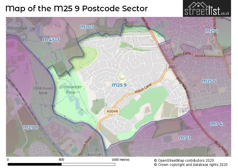
The M25 9 Postcode shares a border with M7 4 (SALFORD), M25 0 (Prestwich), M25 3 (Prestwich), M7 3 (SALFORD), M25 1 (Prestwich), M27 8 (Swinton) and M45 7 (Whitefield).
The sector is within the post town of MANCHESTER.
M25 9 is a postcode sector within the M25 postcode district which is within the M Manchester postcode area.
The Royal Mail delivery office for the M25 9 postal sector is the Prestwich Delivery Office.
The area of the M25 9 postcode sector is 0.93 square miles which is 2.42 square kilometres or 598.13 square acres.
Waterways within the M25 9 postcode sector include the River Irwell.

Map of the M25 9 Postcode Sector
Explore the M25 9 postcode sector by using our free interactive map.
| M | 2 | 5 | - | 9 | X | X |
| M | 2 | 5 | Space | 9 | Letter | Letter |
Official List of Streets
Prestwich (116 Streets)
Unofficial Streets or Alternative Spellings
Prestwich
CHARLTON AVENUE PARK VIEW ROAD SEDGLEY PARK ROAD THORNDYKE WALK WOODHILL DRIVE BRENTWOOD COURT CLOUGH CUMBRIA COURT FLASHFIELDS IRWELL DRIVE KERSAL WOOD AVENUE LADYTHORNE COURT LEAH GARDENS LINKS VIEW LODGESIDE AVENUE PARK VIEW COURT RINGSTONESwinton
AGECROFT ROADSALFORD
KERSAL VALE ROADWeather Forecast for M25 9
Press Button to Show Forecast for Lower Kersal
| Time Period | Icon | Description | Temperature | Rain Probability | Wind |
|---|---|---|---|---|---|
| 21:00 to 00:00 | Partly cloudy (night) | 6.0°C (feels like 5.0°C) | 0.00% | WNW 4 mph |
Press Button to Show Forecast for Lower Kersal
| Time Period | Icon | Description | Temperature | Rain Probability | Wind |
|---|---|---|---|---|---|
| 00:00 to 03:00 | Cloudy | 5.0°C (feels like 4.0°C) | 4.00% | WSW 4 mph | |
| 03:00 to 06:00 | Cloudy | 5.0°C (feels like 3.0°C) | 5.00% | WSW 7 mph | |
| 06:00 to 09:00 | Cloudy | 6.0°C (feels like 4.0°C) | 9.00% | W 7 mph | |
| 09:00 to 12:00 | Cloudy | 8.0°C (feels like 6.0°C) | 9.00% | NW 9 mph | |
| 12:00 to 15:00 | Light rain | 8.0°C (feels like 6.0°C) | 47.00% | NNE 7 mph | |
| 15:00 to 18:00 | Cloudy | 9.0°C (feels like 8.0°C) | 40.00% | NNE 4 mph | |
| 18:00 to 21:00 | Cloudy | 8.0°C (feels like 7.0°C) | 8.00% | ENE 7 mph | |
| 21:00 to 00:00 | Cloudy | 6.0°C (feels like 5.0°C) | 7.00% | NE 7 mph |
Press Button to Show Forecast for Lower Kersal
| Time Period | Icon | Description | Temperature | Rain Probability | Wind |
|---|---|---|---|---|---|
| 00:00 to 03:00 | Cloudy | 4.0°C (feels like 2.0°C) | 5.00% | ENE 7 mph | |
| 03:00 to 06:00 | Clear night | 3.0°C (feels like 1.0°C) | 1.00% | NE 4 mph | |
| 06:00 to 09:00 | Sunny day | 3.0°C (feels like 1.0°C) | 1.00% | NE 4 mph | |
| 09:00 to 12:00 | Partly cloudy (day) | 7.0°C (feels like 5.0°C) | 1.00% | E 4 mph | |
| 12:00 to 15:00 | Overcast | 9.0°C (feels like 8.0°C) | 9.00% | ENE 4 mph | |
| 15:00 to 18:00 | Cloudy | 10.0°C (feels like 9.0°C) | 6.00% | ENE 4 mph | |
| 18:00 to 21:00 | Cloudy | 9.0°C (feels like 9.0°C) | 6.00% | NE 4 mph | |
| 21:00 to 00:00 | Partly cloudy (night) | 6.0°C (feels like 4.0°C) | 4.00% | ENE 7 mph |
Press Button to Show Forecast for Lower Kersal
| Time Period | Icon | Description | Temperature | Rain Probability | Wind |
|---|---|---|---|---|---|
| 00:00 to 03:00 | Partly cloudy (night) | 4.0°C (feels like 2.0°C) | 5.00% | ENE 4 mph | |
| 03:00 to 06:00 | Clear night | 3.0°C (feels like 1.0°C) | 5.00% | ENE 4 mph | |
| 06:00 to 09:00 | Partly cloudy (day) | 4.0°C (feels like 2.0°C) | 5.00% | ENE 4 mph | |
| 09:00 to 12:00 | Partly cloudy (day) | 8.0°C (feels like 6.0°C) | 5.00% | E 7 mph | |
| 12:00 to 15:00 | Overcast | 10.0°C (feels like 8.0°C) | 14.00% | E 7 mph | |
| 15:00 to 18:00 | Cloudy | 10.0°C (feels like 8.0°C) | 17.00% | E 9 mph | |
| 18:00 to 21:00 | Cloudy | 10.0°C (feels like 8.0°C) | 15.00% | ENE 9 mph | |
| 21:00 to 00:00 | Cloudy | 7.0°C (feels like 5.0°C) | 15.00% | ENE 9 mph |
Press Button to Show Forecast for Lower Kersal
| Time Period | Icon | Description | Temperature | Rain Probability | Wind |
|---|---|---|---|---|---|
| 00:00 to 03:00 | Cloudy | 6.0°C (feels like 3.0°C) | 13.00% | NE 9 mph | |
| 03:00 to 06:00 | Cloudy | 6.0°C (feels like 3.0°C) | 15.00% | NE 9 mph | |
| 06:00 to 09:00 | Light rain | 7.0°C (feels like 4.0°C) | 48.00% | NE 9 mph | |
| 09:00 to 12:00 | Light rain | 8.0°C (feels like 5.0°C) | 49.00% | NNE 11 mph | |
| 12:00 to 15:00 | Heavy rain | 9.0°C (feels like 6.0°C) | 78.00% | NNE 11 mph | |
| 15:00 to 18:00 | Heavy rain | 10.0°C (feels like 7.0°C) | 77.00% | N 9 mph | |
| 18:00 to 21:00 | Light rain shower (day) | 10.0°C (feels like 8.0°C) | 39.00% | NNW 9 mph | |
| 21:00 to 00:00 | Partly cloudy (night) | 8.0°C (feels like 6.0°C) | 12.00% | NNW 7 mph |
House Prices in the M25 9 Postcode Sector
| Type of Property | 2018 Average | 2018 Sales | 2017 Average | 2017 Sales | 2016 Average | 2016 Sales | 2015 Average | 2015 Sales |
|---|---|---|---|---|---|---|---|---|
| Detached | £354,081 | 27 | £306,093 | 26 | £337,631 | 29 | £303,282 | 37 |
| Semi-Detached | £244,994 | 59 | £234,015 | 51 | £209,324 | 70 | £176,895 | 66 |
| Terraced | £169,571 | 14 | £179,577 | 22 | £178,342 | 24 | £131,672 | 23 |
| Flats | £115,388 | 26 | £113,942 | 25 | £113,987 | 23 | £86,997 | 18 |
Important Postcodes M25 9 in the Postcode Sector
M25 9RJ is the postcode for Butterstile Cp School, School Grove, Prestwich, and Butterstile Cp School, School Grove
M25 9SA is the postcode for Redcliffe Home for the Elderly, Hilton Lane
| The M25 9 Sector is within these Local Authorities |
|
|---|---|
| The M25 9 Sector is within these Counties |
|
| The M25 9 Sector is within these Water Company Areas |
|