The M26 1 postcode sector is within the county of Greater Manchester.
Did you know? According to the 2021 Census, the M26 1 postcode sector is home to a bustling 11,021 residents!
Given that each sector allows for 400 unique postcode combinations. Letters C, I, K, M, O and V are not allowed in the last two letters of a postcode. With 253 postcodes already in use, this leaves 147 units available.
The M26 1 postal code covers the settlement of Radcliffe.
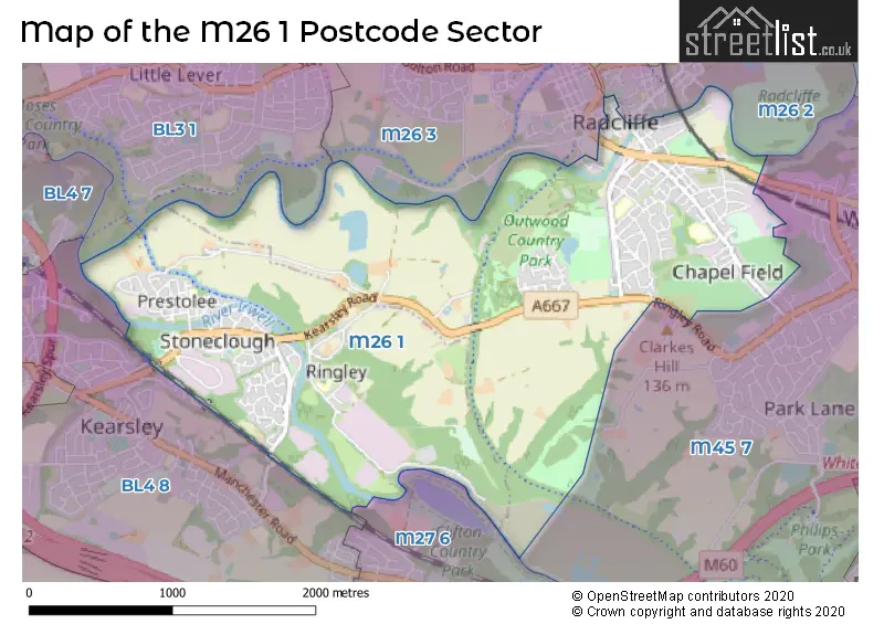
The M26 1 Postcode shares a border with BL3 1 (Little Lever, BOLTON), M26 2 (Radcliffe), M27 6 (Swinton), BL4 8 (Kearsley, Farnworth), M26 3 (Radcliffe) and M45 7 (Whitefield).
The sector is within the post town of MANCHESTER.
M26 1 is a postcode sector within the M26 postcode district which is within the M Manchester postcode area.
The Royal Mail delivery office for the M26 1 postal sector is the Radcliffe Delivery Office.
The area of the M26 1 postcode sector is 3.13 square miles which is 8.11 square kilometres or 2,004.18 square acres.
Waterways within the M26 1 postcode sector include the Irwell, River Irwell, Manchester, Bolton and Bury Canal.

Map of the M26 1 Postcode Sector
Explore the M26 1 postcode sector by using our free interactive map.
| M | 2 | 6 | - | 1 | X | X |
| M | 2 | 6 | Space | 1 | Letter | Letter |
Official List of Streets
Radcliffe (168 Streets)
Unofficial Streets or Alternative Spellings
Radcliffe
DEANSGATE GREEN STREET NEW CHURCH STREET NEW STREET RAILWAY STREET ASHED ROAD BACK ALEXANDRA ROAD BACK BRIDGE STREET BACK CHURCH ROAD BACK CROMPTON ROAD BACK MARKET STREET BACK RINGLEY ROAD BACK RINGLEY ROAD WEST BACK SEDDON LANE BACK WOOD STREET BANK FIELD STREET BELMONT ROAD BROOK STREET CHURCH STREET CLOUGHFOLD CROSS STREET DERBY ROAD EUROPA WAY FACTORY STREET FOUNDRY STREET HOLLOW MEADOWS IRWELL SCULPTURE TRAIL KEARSLEY VALE LODGE ROAD MELLOR STREET MILL STREET MOUNT SION BRIDGE NURSERY BROW OAK HILL BRIDGE OUTWOOD TRAIL PEEL STREET PHOENIX WAY PILKINGTON WAY PINE MEADOW REGAN STREET ROCK STREET SAINT AIDENS CLOSE SAINT JOHNS COURT SAINT JOHNS STREET SAINT PAULS COURT SEDDONS FOLD BRIDGE SHUTTLE STREET ST AIDENS CLOSE ST JOHNS COURT ST JOHNS STREET STONEHEWER STREET SUNNY BANK THE RIVERBANK THORNLEY STREET TOWPATH TREES OF TIME AND PLACEWhitefield
RINGLEY ROADKearsley
STONECLOUGH ROADWeather Forecast for M26 1
Press Button to Show Forecast for Stoneclough
| Time Period | Icon | Description | Temperature | Rain Probability | Wind |
|---|---|---|---|---|---|
| 15:00 to 18:00 | Light rain shower (day) | 9.0°C (feels like 8.0°C) | 43.00% | NNE 4 mph | |
| 18:00 to 21:00 | Cloudy | 8.0°C (feels like 7.0°C) | 8.00% | NE 7 mph | |
| 21:00 to 00:00 | Cloudy | 6.0°C (feels like 4.0°C) | 7.00% | N 4 mph |
Press Button to Show Forecast for Stoneclough
| Time Period | Icon | Description | Temperature | Rain Probability | Wind |
|---|---|---|---|---|---|
| 00:00 to 03:00 | Partly cloudy (night) | 4.0°C (feels like 2.0°C) | 2.00% | ENE 7 mph | |
| 03:00 to 06:00 | Clear night | 3.0°C (feels like 1.0°C) | 1.00% | ENE 4 mph | |
| 06:00 to 09:00 | Sunny day | 3.0°C (feels like 1.0°C) | 1.00% | NE 4 mph | |
| 09:00 to 12:00 | Sunny day | 7.0°C (feels like 5.0°C) | 2.00% | E 4 mph | |
| 12:00 to 15:00 | Overcast | 9.0°C (feels like 8.0°C) | 9.00% | E 4 mph | |
| 15:00 to 18:00 | Cloudy | 10.0°C (feels like 9.0°C) | 6.00% | E 4 mph | |
| 18:00 to 21:00 | Cloudy | 9.0°C (feels like 8.0°C) | 6.00% | NE 4 mph | |
| 21:00 to 00:00 | Partly cloudy (night) | 6.0°C (feels like 4.0°C) | 4.00% | ENE 7 mph |
Press Button to Show Forecast for Stoneclough
| Time Period | Icon | Description | Temperature | Rain Probability | Wind |
|---|---|---|---|---|---|
| 00:00 to 03:00 | Partly cloudy (night) | 4.0°C (feels like 2.0°C) | 5.00% | ENE 4 mph | |
| 03:00 to 06:00 | Partly cloudy (night) | 3.0°C (feels like 1.0°C) | 4.00% | ENE 4 mph | |
| 06:00 to 09:00 | Partly cloudy (day) | 4.0°C (feels like 2.0°C) | 4.00% | ENE 4 mph | |
| 09:00 to 12:00 | Partly cloudy (day) | 8.0°C (feels like 6.0°C) | 5.00% | E 7 mph | |
| 12:00 to 15:00 | Overcast | 10.0°C (feels like 8.0°C) | 15.00% | E 9 mph | |
| 15:00 to 18:00 | Cloudy | 10.0°C (feels like 8.0°C) | 17.00% | E 9 mph | |
| 18:00 to 21:00 | Cloudy | 10.0°C (feels like 7.0°C) | 14.00% | ENE 9 mph | |
| 21:00 to 00:00 | Cloudy | 7.0°C (feels like 4.0°C) | 15.00% | NE 9 mph |
Press Button to Show Forecast for Stoneclough
| Time Period | Icon | Description | Temperature | Rain Probability | Wind |
|---|---|---|---|---|---|
| 00:00 to 03:00 | Cloudy | 6.0°C (feels like 3.0°C) | 16.00% | NE 9 mph | |
| 03:00 to 06:00 | Cloudy | 6.0°C (feels like 3.0°C) | 18.00% | NNE 9 mph | |
| 06:00 to 09:00 | Light rain | 7.0°C (feels like 4.0°C) | 48.00% | NNE 9 mph | |
| 09:00 to 12:00 | Heavy rain | 8.0°C (feels like 5.0°C) | 70.00% | NNE 11 mph | |
| 12:00 to 15:00 | Heavy rain | 9.0°C (feels like 6.0°C) | 75.00% | N 11 mph | |
| 15:00 to 18:00 | Heavy rain | 10.0°C (feels like 7.0°C) | 76.00% | NNW 9 mph | |
| 18:00 to 21:00 | Light rain shower (day) | 10.0°C (feels like 8.0°C) | 36.00% | NNW 9 mph | |
| 21:00 to 00:00 | Clear night | 7.0°C (feels like 6.0°C) | 11.00% | NW 7 mph |
Schools and Places of Education Within the M26 1 Postcode Sector
Chapelfield Primary School
Community school
Clough Street, Manchester, , M26 1LH
Head: Mrs Anna Reed
Ofsted Rating: Good
Inspection: 2023-03-08 (414 days ago)
Website: Visit Chapelfield Primary School Website
Phone: 01617235519
Number of Pupils: 285
St John's Church of England Primary School, Radcliffe
Academy sponsor led
Johnson Street, Bury, , M26 1AW
Head: Mrs Elizabeth Cook
Ofsted Rating: Good
Inspection: 2022-05-18 (708 days ago)
Website: Visit St John's Church of England Primary School, Radcliffe Website
Phone: 01617231078
Number of Pupils: 216
St Saviour CofE Primary School, Ringley
Voluntary aided school
Fold Road, Manchester, , M26 1EU
Head: Mr Jonathan Moorhouse
Ofsted Rating: Outstanding
Inspection: 2011-12-08 (4522 days ago)
Website: Visit St Saviour CofE Primary School, Ringley Website
Phone: 01204333437
Number of Pupils: 208
House Prices in the M26 1 Postcode Sector
| Type of Property | 2018 Average | 2018 Sales | 2017 Average | 2017 Sales | 2016 Average | 2016 Sales | 2015 Average | 2015 Sales |
|---|---|---|---|---|---|---|---|---|
| Detached | £261,020 | 25 | £240,204 | 26 | £228,306 | 26 | £218,514 | 31 |
| Semi-Detached | £146,484 | 67 | £147,078 | 83 | £136,121 | 78 | £136,140 | 78 |
| Terraced | £121,983 | 59 | £113,368 | 70 | £106,787 | 58 | £116,049 | 58 |
| Flats | £86,969 | 26 | £80,874 | 23 | £82,622 | 33 | £77,250 | 18 |
Important Postcodes M26 1 in the Postcode Sector
M26 1AA is the postcode for Royal Mail, Radcliffe Delivery Office, 12 Dale Street
M26 1AW is the postcode for St. Johns C of E School, Johnson Street, and St. Johns C of E School, Johnson Street, Radcliffe
M26 1EU is the postcode for St. Saviour Ringley C of E Primary School, Fold Road
M26 1HJ is the postcode for Prestolee Primary School, Church Road, Radcliffe, and Prestolee Primary School, Church Road
M26 1LH is the postcode for Chapelfield Cp School, Clough Street, and Chapelfield Cp School, Clough Street, Radcliffe
M26 1PN is the postcode for Radcliffe Indoor Market, Market Place
M26 1WR is the postcode for Bury Metropolitan Borough Council, Radcliffe Library, Stand Lane
| The M26 1 Sector is within these Local Authorities |
|
|---|---|
| The M26 1 Sector is within these Counties |
|
| The M26 1 Sector is within these Water Company Areas |
|