The M28 1 postcode sector is within the county of Greater Manchester.
Did you know? According to the 2021 Census, the M28 1 postcode sector is home to a bustling 10,775 residents!
Given that each sector allows for 400 unique postcode combinations. Letters C, I, K, M, O and V are not allowed in the last two letters of a postcode. With 245 postcodes already in use, this leaves 155 units available.
The M28 1 postal code covers the settlement of Worsley.
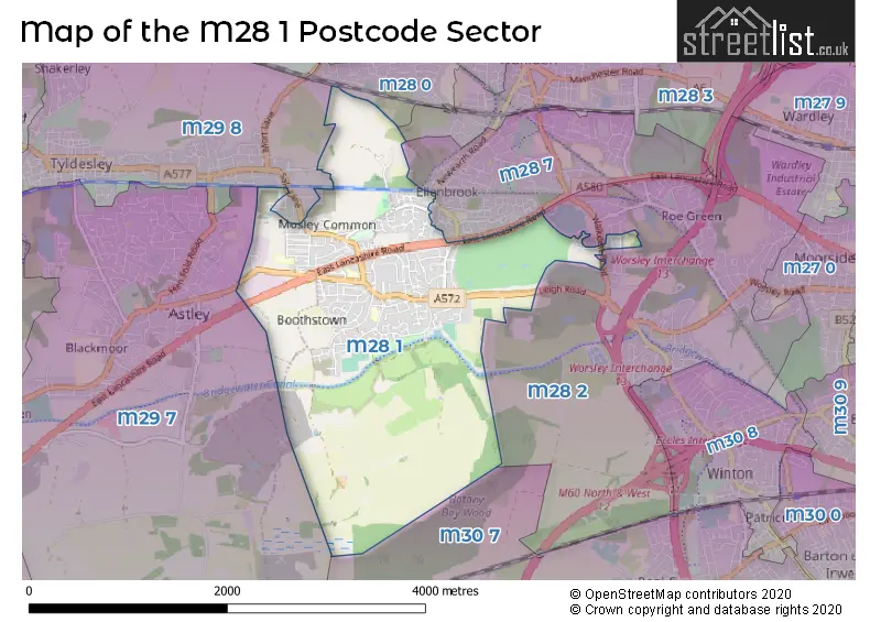
The M28 1 Postcode shares a border with M28 2 (Worsley), M28 3 (Worsley), M29 8 (Tyldesley), M28 0 (Worsley), M28 7 (Worsley), M29 7 (Tyldesley) and M30 7 (Eccles).
The sector is within the post town of MANCHESTER.
M28 1 is a postcode sector within the M28 postcode district which is within the M Manchester postcode area.
The Royal Mail delivery office for the M28 1 postal sector is the North West (m) Delivery Office.
The area of the M28 1 postcode sector is 3.22 square miles which is 8.33 square kilometres or 2,059.22 square acres.
Waterways within the M28 1 postcode sector include the Bridgewater Canal.

Map of the M28 1 Postcode Sector
Explore the M28 1 postcode sector by using our free interactive map.
| M | 2 | 8 | - | 1 | X | X |
| M | 2 | 8 | Space | 1 | Letter | Letter |
Official List of Streets
Worsley (188 Streets)
Unofficial Streets or Alternative Spellings
Worsley
DELAFORD AVENUE LEACONFIELD DRIVE NEWEARTH ROAD THE PADDOCK WALKDEN ROAD WOODLANDS ROAD ARCHER STREET ARNFIELD DRIVE BLOOMFIELD DRIVE BOOTHS HALL BOOTHS HALL BRIDGE BOOTHS HALL WAY BOOTHSTOWN BRIDGE BRIDGEWATER WAY BRINDLEY STREET BULTEEL STREET CHAPPELL LANE COMMON SIDE ROAD EAST MOOR ELLENBROOK LOOPLINE HOLME PARK GARDENS KINNERLY GROVE LEIGH GUIDED BUSWAY MARK STREET MARSDEN STREET NORTH BANK CLOSE NORTH FOLD CLOSE NORTON NOOK OLD HALL LANE ORCHARD STREET PARK LANE PARR BROOK GARDENS PLOUGH FIELDS QUEEN ANN DRIVE SHEEP LANE SHUDEHILL ROAD THE GINNEL THE GORE VICARS HALL BRIDGETyldesley
CHADDOCK LANE GARRETT LANE GARRETT MEADOW LAMBERT MEADOW MOSLEY COMMON ROAD STANLEY FIELDGlazebury
EAST LANCASHIRE ROADWeather Forecast for M28 1
Press Button to Show Forecast for Worsley
| Time Period | Icon | Description | Temperature | Rain Probability | Wind |
|---|---|---|---|---|---|
| 03:00 to 06:00 | Cloudy | 5.0°C (feels like 4.0°C) | 5.00% | WSW 4 mph | |
| 06:00 to 09:00 | Cloudy | 6.0°C (feels like 4.0°C) | 10.00% | WNW 7 mph | |
| 09:00 to 12:00 | Cloudy | 8.0°C (feels like 5.0°C) | 10.00% | NW 9 mph | |
| 12:00 to 15:00 | Light rain | 8.0°C (feels like 6.0°C) | 47.00% | N 9 mph | |
| 15:00 to 18:00 | Cloudy | 9.0°C (feels like 8.0°C) | 49.00% | NNE 4 mph | |
| 18:00 to 21:00 | Cloudy | 9.0°C (feels like 7.0°C) | 12.00% | NNE 7 mph | |
| 21:00 to 00:00 | Cloudy | 6.0°C (feels like 4.0°C) | 7.00% | NNE 4 mph |
Press Button to Show Forecast for Worsley
| Time Period | Icon | Description | Temperature | Rain Probability | Wind |
|---|---|---|---|---|---|
| 00:00 to 03:00 | Partly cloudy (night) | 5.0°C (feels like 2.0°C) | 2.00% | ENE 7 mph | |
| 03:00 to 06:00 | Partly cloudy (night) | 3.0°C (feels like 1.0°C) | 1.00% | NE 4 mph | |
| 06:00 to 09:00 | Partly cloudy (day) | 3.0°C (feels like 1.0°C) | 1.00% | NE 4 mph | |
| 09:00 to 12:00 | Partly cloudy (day) | 7.0°C (feels like 6.0°C) | 2.00% | ENE 4 mph | |
| 12:00 to 15:00 | Cloudy | 9.0°C (feels like 8.0°C) | 9.00% | E 4 mph | |
| 15:00 to 18:00 | Cloudy | 10.0°C (feels like 9.0°C) | 6.00% | E 4 mph | |
| 18:00 to 21:00 | Cloudy | 9.0°C (feels like 9.0°C) | 6.00% | NE 4 mph | |
| 21:00 to 00:00 | Partly cloudy (night) | 6.0°C (feels like 4.0°C) | 4.00% | ENE 7 mph |
Press Button to Show Forecast for Worsley
| Time Period | Icon | Description | Temperature | Rain Probability | Wind |
|---|---|---|---|---|---|
| 00:00 to 03:00 | Partly cloudy (night) | 4.0°C (feels like 2.0°C) | 6.00% | ENE 4 mph | |
| 03:00 to 06:00 | Clear night | 3.0°C (feels like 1.0°C) | 4.00% | ENE 4 mph | |
| 06:00 to 09:00 | Partly cloudy (day) | 4.0°C (feels like 2.0°C) | 4.00% | ENE 7 mph | |
| 09:00 to 12:00 | Partly cloudy (day) | 8.0°C (feels like 6.0°C) | 5.00% | E 7 mph | |
| 12:00 to 15:00 | Overcast | 10.0°C (feels like 8.0°C) | 15.00% | E 7 mph | |
| 15:00 to 18:00 | Overcast | 10.0°C (feels like 8.0°C) | 19.00% | E 9 mph | |
| 18:00 to 21:00 | Cloudy | 10.0°C (feels like 8.0°C) | 14.00% | ENE 9 mph | |
| 21:00 to 00:00 | Cloudy | 7.0°C (feels like 5.0°C) | 15.00% | NE 9 mph |
Press Button to Show Forecast for Worsley
| Time Period | Icon | Description | Temperature | Rain Probability | Wind |
|---|---|---|---|---|---|
| 00:00 to 03:00 | Cloudy | 6.0°C (feels like 3.0°C) | 16.00% | NE 9 mph | |
| 03:00 to 06:00 | Cloudy | 6.0°C (feels like 3.0°C) | 18.00% | NNE 9 mph | |
| 06:00 to 09:00 | Light rain | 7.0°C (feels like 4.0°C) | 48.00% | NNE 9 mph | |
| 09:00 to 12:00 | Heavy rain | 8.0°C (feels like 5.0°C) | 70.00% | NNE 11 mph | |
| 12:00 to 15:00 | Heavy rain | 9.0°C (feels like 6.0°C) | 75.00% | N 11 mph | |
| 15:00 to 18:00 | Heavy rain | 10.0°C (feels like 7.0°C) | 76.00% | NNW 9 mph | |
| 18:00 to 21:00 | Light rain shower (day) | 10.0°C (feels like 8.0°C) | 36.00% | NNW 9 mph | |
| 21:00 to 00:00 | Partly cloudy (night) | 7.0°C (feels like 6.0°C) | 12.00% | NW 7 mph |
Schools and Places of Education Within the M28 1 Postcode Sector
Boothstown Methodist Primary School
Voluntary controlled school
6 Chapel Street, Manchester, , M28 1DG
Head: Miss Karen Armfield
Ofsted Rating: Good
Inspection: 2021-07-15 (1015 days ago)
Website: Visit Boothstown Methodist Primary School Website
Phone: 01617903263
Number of Pupils: 210
Holy Family Catholic Primary School
Voluntary aided school
Kendal Road, Manchester, , M28 1AG
Head: Mrs Clare Roberts
Ofsted Rating: Good
Inspection: 2019-02-27 (1884 days ago)
Website: Visit Holy Family Catholic Primary School Website
Phone: 01617902123
Number of Pupils: 199
St Andrew's CofE Primary School
Voluntary controlled school
Vicars Hall Lane, Manchester, , M28 1HS
Head: Mr Michael Platt
Ofsted Rating: Outstanding
Inspection: 2013-03-15 (4059 days ago)
Website: Visit St Andrew's CofE Primary School Website
Phone: 01619211640
Number of Pupils: 471
St John's CofE Primary School Mosley Common
Voluntary aided school
Commonside Road, Manchester, , M28 1AE
Head: Miss Andrea Heaton
Ofsted Rating: Good
Inspection: 2023-06-15 (315 days ago)
Website: Visit St John's CofE Primary School Mosley Common Website
Phone: 01617902195
Number of Pupils: 184
House Prices in the M28 1 Postcode Sector
| Type of Property | 2018 Average | 2018 Sales | 2017 Average | 2017 Sales | 2016 Average | 2016 Sales | 2015 Average | 2015 Sales |
|---|---|---|---|---|---|---|---|---|
| Detached | £356,992 | 62 | £314,071 | 69 | £377,419 | 77 | £296,841 | 58 |
| Semi-Detached | £190,791 | 86 | £203,294 | 80 | £193,001 | 114 | £158,297 | 77 |
| Terraced | £177,420 | 57 | £161,710 | 59 | £148,731 | 49 | £145,935 | 43 |
| Flats | £204,000 | 2 | £224,300 | 10 | £111,542 | 13 | £80,000 | 4 |
Important Postcodes M28 1 in the Postcode Sector
M28 1AE is the postcode for SURE START BUILDING, St. Johns Mosley Common C of E Primary School, Commonside Road, and MAIN BUILDING, St. Johns Mosley Common C of E Primary School, Commonside Road
M28 1AG is the postcode for Boothstown Holy Family RC Junior & Infant School, Kendal Road, Worsley, and Boothstown Holy Family RC Junior & Infant School, Kendal Road
M28 1BZ is the postcode for 239, Mosley Common Road, Worsley
M28 1DG is the postcode for Boothstown Methodist School, 6 Chapel Street, and BOOTHSTOWN METHODIST PRIMARY SCHOOL, CHAPEL STREET
M28 1HS is the postcode for St. Andrew Primary School, Vicars Hall Lane, and St Andrew's CE Primary School, Vicars Hall Lane, Boothstown
M28 1NB is the postcode for Boothstown Community Centre & Library, Standfield Road, Boothstown
M28 1PB is the postcode for Ellenbrook Medical Centre, 14 Morston Close
| The M28 1 Sector is within these Local Authorities |
|
|---|---|
| The M28 1 Sector is within these Counties |
|
| The M28 1 Sector is within these Water Company Areas |
|