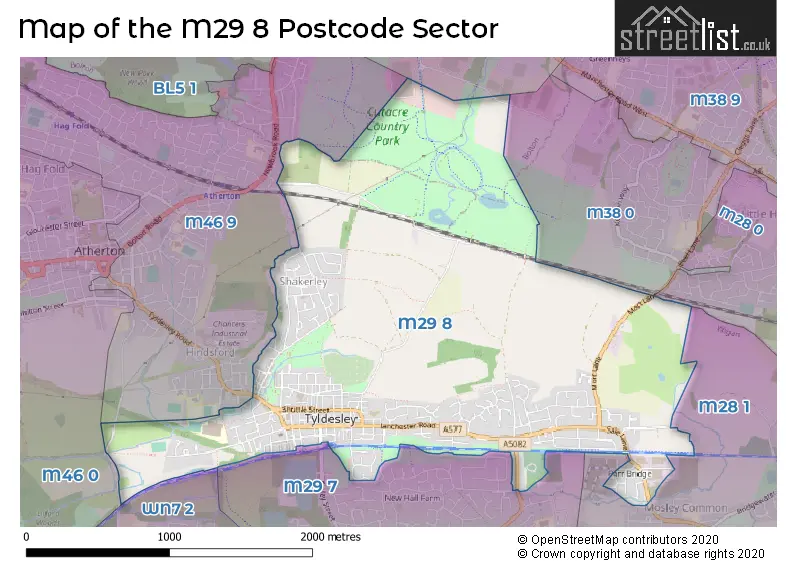
The M29 8 postcode sector is within the county of Greater Manchester.
Did you know? According to the 2021 Census, the M29 8 postcode sector is home to a bustling 10,478 residents!
Given that each sector allows for 400 unique postcode combinations. Letters C, I, K, M, O and V are not allowed in the last two letters of a postcode. With 272 postcodes already in use, this leaves 128 units available.
The M29 8 postal code covers the settlement of Tyldesley.
The M29 8 Postcode shares a border with WN7 2 (LEIGH), M46 0 (Atherton), BL5 1 (BOLTON, Over Hulton), M28 0 (Worsley), M28 1 (Worsley), M29 7 (Tyldesley), M38 0 (Little Hulton) and M46 9 (Atherton).
The sector is within the post town of MANCHESTER.
M29 8 is a postcode sector within the M29 postcode district which is within the M Manchester postcode area.
The Royal Mail delivery office for the M29 8 postal sector is the Tyldesley Delivery Office.
The area of the M29 8 postcode sector is 2.35 square miles which is 6.09 square kilometres or 1,505.79 square acres.

Map of the M29 8 Postcode Sector
Explore the M29 8 postcode sector by using our free interactive map.
| M | 2 | 9 | - | 8 | X | X |
| M | 2 | 9 | Space | 8 | Letter | Letter |
Official List of Streets
Tyldesley (196 Streets)
Unofficial Streets or Alternative Spellings
Tyldesley
BODMIN ROADAtherton
HINDSFORD STREET PRINTSHOP LANE SHAKERLEY LANE TYLDESLEY ROAD ALFRED STREET BACK LANE COBDEN STREET CRANSHAW STREET FRANCIS STREET HART STREET HEN FOLD ROAD HILLCREST ROAD LANGLEY PLATT LANE LEIGH GUIDED BUSWAY MILLERS LANE PATCHETT STREET PETER STREET PRESCOT AVENUE RAILWAY STREET RATCLIFFE STREET ROWE STREET SAINT GEORGES STREET SHAKERLEY LANE ST GEORGES COURT THE GORE TYLDESLEY PASSAGE UNSWORTH STREET WHEWELL STREETBOLTON
LOMAX WAYWorsley
SILK MILL STREETWeather Forecast for M29 8
Press Button to Show Forecast for Tyldesley
| Time Period | Icon | Description | Temperature | Rain Probability | Wind |
|---|---|---|---|---|---|
| 12:00 to 15:00 | Light rain shower (day) | 8.0°C (feels like 6.0°C) | 36.00% | N 9 mph | |
| 15:00 to 18:00 | Partly cloudy (day) | 9.0°C (feels like 8.0°C) | 34.00% | NNE 4 mph | |
| 18:00 to 21:00 | Cloudy | 8.0°C (feels like 7.0°C) | 9.00% | N 7 mph | |
| 21:00 to 00:00 | Cloudy | 6.0°C (feels like 4.0°C) | 7.00% | NNE 4 mph |
Press Button to Show Forecast for Tyldesley
| Time Period | Icon | Description | Temperature | Rain Probability | Wind |
|---|---|---|---|---|---|
| 00:00 to 03:00 | Partly cloudy (night) | 5.0°C (feels like 2.0°C) | 2.00% | ENE 7 mph | |
| 03:00 to 06:00 | Partly cloudy (night) | 3.0°C (feels like 1.0°C) | 1.00% | ENE 4 mph | |
| 06:00 to 09:00 | Sunny day | 3.0°C (feels like 1.0°C) | 1.00% | ENE 4 mph | |
| 09:00 to 12:00 | Partly cloudy (day) | 7.0°C (feels like 6.0°C) | 2.00% | E 4 mph | |
| 12:00 to 15:00 | Cloudy | 9.0°C (feels like 8.0°C) | 9.00% | E 4 mph | |
| 15:00 to 18:00 | Cloudy | 10.0°C (feels like 9.0°C) | 6.00% | ENE 4 mph | |
| 18:00 to 21:00 | Cloudy | 9.0°C (feels like 8.0°C) | 6.00% | NE 4 mph | |
| 21:00 to 00:00 | Partly cloudy (night) | 6.0°C (feels like 4.0°C) | 4.00% | ENE 7 mph |
Press Button to Show Forecast for Tyldesley
| Time Period | Icon | Description | Temperature | Rain Probability | Wind |
|---|---|---|---|---|---|
| 00:00 to 03:00 | Partly cloudy (night) | 4.0°C (feels like 2.0°C) | 5.00% | ENE 4 mph | |
| 03:00 to 06:00 | Clear night | 3.0°C (feels like 1.0°C) | 4.00% | ENE 4 mph | |
| 06:00 to 09:00 | Cloudy | 4.0°C (feels like 2.0°C) | 7.00% | ENE 7 mph | |
| 09:00 to 12:00 | Partly cloudy (day) | 8.0°C (feels like 6.0°C) | 5.00% | E 7 mph | |
| 12:00 to 15:00 | Overcast | 10.0°C (feels like 8.0°C) | 15.00% | E 7 mph | |
| 15:00 to 18:00 | Overcast | 10.0°C (feels like 8.0°C) | 19.00% | E 9 mph | |
| 18:00 to 21:00 | Cloudy | 10.0°C (feels like 8.0°C) | 14.00% | ENE 9 mph | |
| 21:00 to 00:00 | Cloudy | 7.0°C (feels like 5.0°C) | 15.00% | NE 9 mph |
Press Button to Show Forecast for Tyldesley
| Time Period | Icon | Description | Temperature | Rain Probability | Wind |
|---|---|---|---|---|---|
| 00:00 to 03:00 | Cloudy | 6.0°C (feels like 3.0°C) | 16.00% | NE 9 mph | |
| 03:00 to 06:00 | Cloudy | 6.0°C (feels like 3.0°C) | 18.00% | NNE 9 mph | |
| 06:00 to 09:00 | Light rain | 7.0°C (feels like 4.0°C) | 48.00% | NNE 9 mph | |
| 09:00 to 12:00 | Heavy rain | 8.0°C (feels like 5.0°C) | 70.00% | NNE 11 mph | |
| 12:00 to 15:00 | Heavy rain | 9.0°C (feels like 6.0°C) | 75.00% | N 11 mph | |
| 15:00 to 18:00 | Heavy rain | 9.0°C (feels like 7.0°C) | 78.00% | NNW 9 mph | |
| 18:00 to 21:00 | Light rain shower (day) | 10.0°C (feels like 8.0°C) | 36.00% | NNW 9 mph | |
| 21:00 to 00:00 | Clear night | 7.0°C (feels like 6.0°C) | 11.00% | NW 7 mph |
Schools and Places of Education Within the M29 8 Postcode Sector
Cambian Tyldesley School
Other independent special school
Shuttle Street, Manchester, , M29 8BS
Head: Mrs Jemma Westby
Ofsted Rating: Good
Inspection: 2021-11-25 (882 days ago)
Website: Visit Cambian Tyldesley School Website
Phone: 01942877660
Number of Pupils: 27
Fred Longworth High School
Academy converter
Printshop Lane, Manchester, , M29 8JN
Head: Mr Paul Davies
Ofsted Rating: Good
Inspection: 2022-10-19 (554 days ago)
Website: Visit Fred Longworth High School Website
Phone: 01942883796
Number of Pupils: 1278
Progress Schools - Lilford Centre
Other independent school
The Lilford Centre, Wigan, , M29 8LN
Head: Mr Andrew Fletcher
Ofsted Rating: Inadequate
Inspection: 2022-07-14 (651 days ago)
Website: Visit Progress Schools - Lilford Centre Website
Phone: 01515591867
Number of Pupils: 23
Tyldesley St George's Central CofE Primary School and Nursery
Voluntary aided school
Darlington Street, Manchester, Greater Manchester, M29 8DH
Head: Mr Mark Grogan
Ofsted Rating: Good
Inspection: 2023-06-15 (315 days ago)
Website: Visit Tyldesley St George's Central CofE Primary School and Nursery Website
Phone: 01942883773
Number of Pupils: 337
House Prices in the M29 8 Postcode Sector
| Type of Property | 2018 Average | 2018 Sales | 2017 Average | 2017 Sales | 2016 Average | 2016 Sales | 2015 Average | 2015 Sales |
|---|---|---|---|---|---|---|---|---|
| Detached | £291,111 | 89 | £276,557 | 49 | £214,355 | 39 | £185,092 | 38 |
| Semi-Detached | £149,827 | 60 | £134,718 | 73 | £127,484 | 44 | £125,544 | 37 |
| Terraced | £101,396 | 106 | £90,755 | 64 | £84,179 | 72 | £81,583 | 66 |
| Flats | £95,038 | 13 | £68,938 | 8 | £67,573 | 13 | £82,259 | 6 |
Important Postcodes M29 8 in the Postcode Sector
M29 8AX is the postcode for Clinic, Tyldesley Health Centre, and Tyldesley Clinic, Poplar Street, Tyldesley
M29 8DH is the postcode for St. Georges Central C E School, Darlington Street, Tyldesley, and St. Georges Central C E School, Darlington Street
M29 8EG is the postcode for The Pelican Centre, Castle Street, Tyldesley, and The Pelican Centre, Castle Street
M29 8EH is the postcode for Town Hall, Elliott Street
M29 8JN is the postcode for SCIENCE BLOCK, Fred Longworth High School, Printshop Lane, Fred Longworth High School, Printshop Lane, MAIN BUILDING, Fred Longworth High School, Printshop Lane, and ART BLOCK, Fred Longworth High School, Printshop Lane
M29 8WS is the postcode for FOURWAYS RESIDENTIAL UNIT, Fourways Assessment Unit, Cleworth Hall Lane, and Fourways Assessment Unit, Cleworth Hall Lane
| The M29 8 Sector is within these Local Authorities |
|
|---|---|
| The M29 8 Sector is within these Counties |
|
| The M29 8 Sector is within these Water Company Areas |
|