The M32 9 postcode sector is within the county of Greater Manchester.
Did you know? According to the 2021 Census, the M32 9 postcode sector is home to a bustling 11,402 residents!
Given that each sector allows for 400 unique postcode combinations. Letters C, I, K, M, O and V are not allowed in the last two letters of a postcode. With 210 postcodes already in use, this leaves 190 units available.
The M32 9 postal code covers the settlement of Stretford.
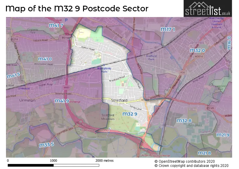
The M32 9 Postcode shares a border with M32 8 (Stretford), M41 9 (Urmston), M41 7 (Urmston), M32 0 (Stretford) and M41 0 (Urmston).
The sector is within the post town of MANCHESTER.
M32 9 is a postcode sector within the M32 postcode district which is within the M Manchester postcode area.
The Royal Mail delivery office for the M32 9 postal sector is the Stretford Delivery Office.
The area of the M32 9 postcode sector is 0.94 square miles which is 2.44 square kilometres or 601.71 square acres.
The M32 9 postcode sector is crossed by the M60 motorway.
Waterways within the M32 9 postcode sector include the River Mersey.

Map of the M32 9 Postcode Sector
Explore the M32 9 postcode sector by using our free interactive map.
| M | 3 | 2 | - | 9 | X | X |
| M | 3 | 2 | Space | 9 | Letter | Letter |
Official List of Streets
Stretford (99 Streets)
Unofficial Streets or Alternative Spellings
Stretford
ALSTON AVENUE DERBYSHIRE LANE EDGE LANE ELMWOOD COURT GREEN STREET KINGSWAY LACY STREET LYNDHURST ROAD MELVILLE ROAD NEWTON STREET PARK ROAD RAGLAN ROAD THE FURROWS ALL SAINTS COURT ARRAN AVENUE BARFOOT AQUEDUCT BARFOOT BRIDGE BASLOW ROAD BRAESIDE BRIDGEWATER WAY COB HALL ROAD GLAMIS AVENUE HUMPHREY PARK SUBWAY LOSTOCK CIRCLE LOSTOCK COURT LOSTOCK SUBWAY MANOR COURT MEADOW BANK COURT PARK WAY PETERWOOD GARDENS SEVENWAYS SOUTHWELL COURT ST. GEORGES COURT ST. MATTHEWS COURT THE CIRCLE WELLINGTON HOUSE WILMINGTON ROADOld Trafford
CHESTER ROADUrmston
HUMPHREY LANE MOSS VALE ROAD STRETFORD ROADWeather Forecast for M32 9
Press Button to Show Forecast for Stretford
| Time Period | Icon | Description | Temperature | Rain Probability | Wind |
|---|---|---|---|---|---|
| 06:00 to 09:00 | Cloudy | 6.0°C (feels like 4.0°C) | 8.00% | W 7 mph | |
| 09:00 to 12:00 | Cloudy | 8.0°C (feels like 5.0°C) | 48.00% | NW 9 mph | |
| 12:00 to 15:00 | Light rain | 8.0°C (feels like 6.0°C) | 48.00% | NNE 7 mph | |
| 15:00 to 18:00 | Cloudy | 9.0°C (feels like 8.0°C) | 6.00% | NNE 4 mph | |
| 18:00 to 21:00 | Light rain | 9.0°C (feels like 8.0°C) | 50.00% | ENE 4 mph | |
| 21:00 to 00:00 | Cloudy | 7.0°C (feels like 5.0°C) | 10.00% | ENE 4 mph |
Press Button to Show Forecast for Stretford
| Time Period | Icon | Description | Temperature | Rain Probability | Wind |
|---|---|---|---|---|---|
| 00:00 to 03:00 | Partly cloudy (night) | 5.0°C (feels like 3.0°C) | 2.00% | E 4 mph | |
| 03:00 to 06:00 | Partly cloudy (night) | 3.0°C (feels like 2.0°C) | 1.00% | ENE 4 mph | |
| 06:00 to 09:00 | Partly cloudy (day) | 4.0°C (feels like 2.0°C) | 1.00% | ENE 4 mph | |
| 09:00 to 12:00 | Partly cloudy (day) | 7.0°C (feels like 6.0°C) | 2.00% | ENE 4 mph | |
| 12:00 to 15:00 | Cloudy | 9.0°C (feels like 8.0°C) | 9.00% | E 4 mph | |
| 15:00 to 18:00 | Cloudy | 10.0°C (feels like 9.0°C) | 8.00% | E 4 mph | |
| 18:00 to 21:00 | Cloudy | 10.0°C (feels like 9.0°C) | 7.00% | NE 4 mph | |
| 21:00 to 00:00 | Partly cloudy (night) | 6.0°C (feels like 4.0°C) | 4.00% | ENE 7 mph |
Press Button to Show Forecast for Stretford
| Time Period | Icon | Description | Temperature | Rain Probability | Wind |
|---|---|---|---|---|---|
| 00:00 to 03:00 | Partly cloudy (night) | 4.0°C (feels like 2.0°C) | 6.00% | ENE 4 mph | |
| 03:00 to 06:00 | Partly cloudy (night) | 3.0°C (feels like 1.0°C) | 6.00% | ENE 4 mph | |
| 06:00 to 09:00 | Partly cloudy (day) | 5.0°C (feels like 3.0°C) | 6.00% | ENE 4 mph | |
| 09:00 to 12:00 | Cloudy | 8.0°C (feels like 6.0°C) | 8.00% | E 7 mph | |
| 12:00 to 15:00 | Overcast | 10.0°C (feels like 9.0°C) | 16.00% | E 7 mph | |
| 15:00 to 18:00 | Cloudy | 11.0°C (feels like 9.0°C) | 18.00% | ENE 9 mph | |
| 18:00 to 21:00 | Cloudy | 10.0°C (feels like 8.0°C) | 15.00% | ENE 9 mph | |
| 21:00 to 00:00 | Cloudy | 7.0°C (feels like 5.0°C) | 17.00% | NE 9 mph |
Press Button to Show Forecast for Stretford
| Time Period | Icon | Description | Temperature | Rain Probability | Wind |
|---|---|---|---|---|---|
| 00:00 to 03:00 | Cloudy | 6.0°C (feels like 4.0°C) | 16.00% | NE 9 mph | |
| 03:00 to 06:00 | Cloudy | 6.0°C (feels like 4.0°C) | 19.00% | NNE 9 mph | |
| 06:00 to 09:00 | Cloudy | 7.0°C (feels like 4.0°C) | 20.00% | NNE 9 mph | |
| 09:00 to 12:00 | Light rain | 8.0°C (feels like 5.0°C) | 50.00% | NNE 11 mph | |
| 12:00 to 15:00 | Heavy rain | 9.0°C (feels like 6.0°C) | 76.00% | N 11 mph | |
| 15:00 to 18:00 | Light rain | 10.0°C (feels like 7.0°C) | 57.00% | NNE 9 mph | |
| 18:00 to 21:00 | Cloudy | 10.0°C (feels like 8.0°C) | 18.00% | N 9 mph | |
| 21:00 to 00:00 | Partly cloudy (night) | 8.0°C (feels like 6.0°C) | 10.00% | NW 7 mph |
Schools and Places of Education Within the M32 9 Postcode Sector
Barton Clough Primary School
Academy sponsor led
Audley Avenue, Manchester, , M32 9TG
Head: Mr Jonathan Foster-Carr
Ofsted Rating: Requires improvement
Inspection: 2022-06-16 (679 days ago)
Website: Visit Barton Clough Primary School Website
Phone: 01617487539
Number of Pupils: 173
Lostock High School
Community school
Selby Road, Manchester, , M32 9PL
Head: Mrs Lindsay Brindley
Ofsted Rating: Good
Inspection: 2021-09-22 (946 days ago)
Website: Visit Lostock High School Website
Phone: 01618645700
Number of Pupils: 422
Moss Park Primary School
Community school
Moss Park Road, Manchester, , M32 9HR
Head: Mrs S Nunwick
Ofsted Rating: Outstanding
Inspection: 2009-04-02 (5502 days ago)
Website: Visit Moss Park Primary School Website
Phone: 01618641710
Number of Pupils: 254
St Hugh of Lincoln RC Primary School
Voluntary aided school
Glastonbury Road, Stretford, , M32 9PD
Head: Mr Adrian/Maureen Smith/Atherton
Ofsted Rating: Outstanding
Inspection: 2009-03-25 (5510 days ago)
Website: Visit St Hugh of Lincoln RC Primary School Website
Phone: 01619122906
Number of Pupils: 337
St Matthew's CofE Primary School
Voluntary controlled school
Poplar Road, Manchester, , M32 9AN
Head: Miss Shelley Lynton
Ofsted Rating: Good
Inspection: 2022-06-23 (672 days ago)
Website: Visit St Matthew's CofE Primary School Website
Phone: 01618651284
Number of Pupils: 203
The Orchards
Free schools special
Audley Avenue, Stretford, Greater Manchester, M32 9TG
Head: Ms Helen O'Brien
Ofsted Rating: Good
Inspection: 2019-07-10 (1751 days ago)
Website: Visit The Orchards Website
Phone: 01617480670
Number of Pupils: 125
House Prices in the M32 9 Postcode Sector
| Type of Property | 2018 Average | 2018 Sales | 2017 Average | 2017 Sales | 2016 Average | 2016 Sales | 2015 Average | 2015 Sales |
|---|---|---|---|---|---|---|---|---|
| Detached | £321,778 | 9 | £300,107 | 14 | £259,267 | 15 | £223,313 | 8 |
| Semi-Detached | £233,472 | 100 | £208,634 | 78 | £209,366 | 86 | £174,277 | 86 |
| Terraced | £209,717 | 24 | £176,452 | 32 | £174,078 | 25 | £142,393 | 28 |
| Flats | £100,464 | 14 | £99,041 | 17 | £93,826 | 19 | £83,636 | 18 |
Important Postcodes M32 9 in the Postcode Sector
M32 9AN is the postcode for St. Matthews C of E Primary School, Poplar Road, and Stretford Childrens Centre, 9 Poplar Road
M32 9ED is the postcode for Arndale House, Chester Road, and Jobcentre Plus, Arndale House, Chester Road, Stretford
M32 9HR is the postcode for Moss Park Junior School, Moss Park Road, Moss Park Primary School, Moss Park Road, Moss Park Infant School, Moss Park Road, and Moss Park Junior School & Moss Park Infant School, Moss Park Road
M32 9PD is the postcode for St. Hugh of Lincoln Primary School, Glastonbury Road, and St. Hugh of Lincoln Primary School, Glastonbury Road, Stretford
M32 9PL is the postcode for SUCCEED BUILDING, Lostock High School, Selby Road, Lostock High School, Selby Road, TRANSFORM BUILDING, Lostock High School, Selby Road, INSPIRE BUILDING, Lostock High School, Selby Road, BLOCK B, Lostock High School, Selby Road, and BLOCK C / THEATRE AND DANCE., Lostock High School, Selby Road
M32 9TG is the postcode for Barton Clough Primary School, Audley Avenue, and The Orchards School, Audley Avenue
| The M32 9 Sector is within these Local Authorities |
|
|---|---|
| The M32 9 Sector is within these Counties |
|
| The M32 9 Sector is within these Water Company Areas |
|