The M33 2 postcode sector is within the county of Greater Manchester.
Did you know? According to the 2021 Census, the M33 2 postcode sector is home to a bustling 13,399 residents!
Given that each sector allows for 400 unique postcode combinations. Letters C, I, K, M, O and V are not allowed in the last two letters of a postcode. With 314 postcodes already in use, this leaves 86 units available.
The M33 2 postal code covers the settlement of SALE.
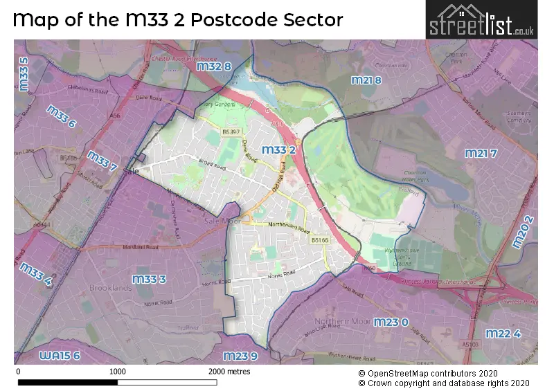
The M33 2 Postcode shares a border with M21 7 (MANCHESTER, Chorlton Cum Hardy), M23 0 (MANCHESTER, Wythenshawe), M23 9 (MANCHESTER, Roundthorn Industrial Estate, Wythenshawe), M32 8 (Stretford), M21 8 (MANCHESTER, Chorlton Cum Hardy), M33 7 (SALE) and M33 3 (SALE, Brooklands).
The sector is within the post town of SALE.
M33 2 is a postcode sector within the M33 postcode district which is within the M Manchester postcode area.
The Royal Mail delivery office for the M33 2 postal sector is the Sale Delivery Office.
The area of the M33 2 postcode sector is 1.58 square miles which is 4.09 square kilometres or 1,009.87 square acres.
The M33 2 postcode sector is crossed by the M60 motorway.
Waterways within the M33 2 postcode sector include the River Mersey.

Map of the M33 2 Postcode Sector
Explore the M33 2 postcode sector by using our free interactive map.
| M | 3 | 3 | - | 2 | X | X |
| M | 3 | 3 | Space | 2 | Letter | Letter |
Official List of Streets
SALE (163 Streets)
Unofficial Streets or Alternative Spellings
SALE
ALICE STREET HAMPSON STREET HOPE ROAD MARSLAND ROAD OCCLESTON CLOSE SCHOOL ROAD WARRENER STREET ABBOTS COURT ABERCROMBIE COURT ALBANY COURT BACARA COURT BANK STREET BEBINGTON CLOSE BEECH VILLAS BROOK STREET COW LANE GLEN MAYE GROVE COURT HEATHFIELD AVENUE HIGH LEE HOUSE HOLME LEA JACKSONS BRIDGE JOIN ROAD LINDOW COURT MERSEY COURT NORFOLK HOUSE PARKLANDS PEGASUS COURT PERIMETER PATH: SALE WATER PARK PINEWOOD COURT ROOKFIELD COURT ROWSON COURT SHORTCUT INTO SALE WATER PARK SOUTHGATE COURT STEPPING STONES WARWICK HOUSE WILLOW COURT WORTHINGTON COURTWythenshawe
SALE ROADWeather Forecast for M33 2
Press Button to Show Forecast for Sale
| Time Period | Icon | Description | Temperature | Rain Probability | Wind |
|---|---|---|---|---|---|
| 06:00 to 09:00 | Cloudy | 6.0°C (feels like 4.0°C) | 9.00% | W 7 mph | |
| 09:00 to 12:00 | Cloudy | 8.0°C (feels like 5.0°C) | 43.00% | NW 9 mph | |
| 12:00 to 15:00 | Light rain | 8.0°C (feels like 6.0°C) | 48.00% | NNE 7 mph | |
| 15:00 to 18:00 | Cloudy | 9.0°C (feels like 9.0°C) | 8.00% | NNW 4 mph | |
| 18:00 to 21:00 | Light rain | 9.0°C (feels like 8.0°C) | 46.00% | E 4 mph | |
| 21:00 to 00:00 | Cloudy | 6.0°C (feels like 5.0°C) | 11.00% | NE 4 mph |
Press Button to Show Forecast for Sale
| Time Period | Icon | Description | Temperature | Rain Probability | Wind |
|---|---|---|---|---|---|
| 00:00 to 03:00 | Partly cloudy (night) | 5.0°C (feels like 3.0°C) | 2.00% | E 4 mph | |
| 03:00 to 06:00 | Partly cloudy (night) | 3.0°C (feels like 1.0°C) | 1.00% | ENE 4 mph | |
| 06:00 to 09:00 | Partly cloudy (day) | 4.0°C (feels like 2.0°C) | 1.00% | ENE 4 mph | |
| 09:00 to 12:00 | Partly cloudy (day) | 7.0°C (feels like 6.0°C) | 2.00% | ENE 4 mph | |
| 12:00 to 15:00 | Cloudy | 9.0°C (feels like 8.0°C) | 9.00% | E 4 mph | |
| 15:00 to 18:00 | Cloudy | 10.0°C (feels like 9.0°C) | 8.00% | E 4 mph | |
| 18:00 to 21:00 | Cloudy | 10.0°C (feels like 9.0°C) | 7.00% | NE 4 mph | |
| 21:00 to 00:00 | Partly cloudy (night) | 6.0°C (feels like 4.0°C) | 4.00% | ENE 7 mph |
Press Button to Show Forecast for Sale
| Time Period | Icon | Description | Temperature | Rain Probability | Wind |
|---|---|---|---|---|---|
| 00:00 to 03:00 | Partly cloudy (night) | 4.0°C (feels like 2.0°C) | 6.00% | ENE 4 mph | |
| 03:00 to 06:00 | Partly cloudy (night) | 3.0°C (feels like 1.0°C) | 6.00% | ENE 4 mph | |
| 06:00 to 09:00 | Partly cloudy (day) | 5.0°C (feels like 3.0°C) | 6.00% | ENE 4 mph | |
| 09:00 to 12:00 | Cloudy | 8.0°C (feels like 7.0°C) | 8.00% | E 7 mph | |
| 12:00 to 15:00 | Overcast | 10.0°C (feels like 9.0°C) | 16.00% | E 7 mph | |
| 15:00 to 18:00 | Cloudy | 11.0°C (feels like 9.0°C) | 18.00% | ENE 9 mph | |
| 18:00 to 21:00 | Cloudy | 10.0°C (feels like 8.0°C) | 15.00% | ENE 9 mph | |
| 21:00 to 00:00 | Cloudy | 7.0°C (feels like 5.0°C) | 17.00% | NE 9 mph |
Press Button to Show Forecast for Sale
| Time Period | Icon | Description | Temperature | Rain Probability | Wind |
|---|---|---|---|---|---|
| 00:00 to 03:00 | Cloudy | 6.0°C (feels like 4.0°C) | 16.00% | NE 9 mph | |
| 03:00 to 06:00 | Cloudy | 6.0°C (feels like 4.0°C) | 21.00% | NNE 9 mph | |
| 06:00 to 09:00 | Cloudy | 7.0°C (feels like 4.0°C) | 20.00% | NNE 9 mph | |
| 09:00 to 12:00 | Light rain | 8.0°C (feels like 5.0°C) | 50.00% | NNE 11 mph | |
| 12:00 to 15:00 | Heavy rain | 9.0°C (feels like 6.0°C) | 76.00% | N 11 mph | |
| 15:00 to 18:00 | Light rain | 10.0°C (feels like 7.0°C) | 57.00% | N 9 mph | |
| 18:00 to 21:00 | Cloudy | 10.0°C (feels like 8.0°C) | 18.00% | N 9 mph | |
| 21:00 to 00:00 | Partly cloudy (night) | 8.0°C (feels like 6.0°C) | 10.00% | NW 7 mph |
Schools and Places of Education Within the M33 2 Postcode Sector
Holy Family Catholic Primary School
Voluntary aided school
Old Hall Road, Sale, Cheshire, M33 2JA
Head: Linda Davison
Ofsted Rating: Good
Inspection: 2022-10-07 (566 days ago)
Website: Visit Holy Family Catholic Primary School Website
Phone: 01619625397
Number of Pupils: 217
Moorlands Junior School
Community school
Temple Road, Sale, Cheshire, M33 2LP
Head: Miss Alison Kelly
Ofsted Rating: Good
Inspection: 2023-05-17 (344 days ago)
Website: Visit Moorlands Junior School Website
Phone: 01619625452
Number of Pupils: 273
Templemoor Infant and Nursery School
Community school
Nursery Close, Sale, Cheshire, M33 2EG
Head: Mrs Shirley Brown
Ofsted Rating: Good
Inspection: 2023-11-09 (168 days ago)
Website: Visit Templemoor Infant and Nursery School Website
Phone: 01619691622
Number of Pupils: 206
Worthington Primary School
Community school
Worthington Road, Sale, Cheshire, M33 2JJ
Head: Mrs Sarah Jones
Ofsted Rating: Good
Inspection: 2020-02-19 (1527 days ago)
Website: Visit Worthington Primary School Website
Phone: 01619733504
Number of Pupils: 452
House Prices in the M33 2 Postcode Sector
| Type of Property | 2018 Average | 2018 Sales | 2017 Average | 2017 Sales | 2016 Average | 2016 Sales | 2015 Average | 2015 Sales |
|---|---|---|---|---|---|---|---|---|
| Detached | £455,245 | 22 | £414,946 | 20 | £400,108 | 24 | £343,087 | 15 |
| Semi-Detached | £307,813 | 115 | £332,750 | 98 | £305,975 | 98 | £261,065 | 102 |
| Terraced | £287,406 | 62 | £224,379 | 38 | £231,716 | 71 | £211,934 | 51 |
| Flats | £154,812 | 40 | £143,256 | 44 | £142,097 | 60 | £132,262 | 41 |
Important Postcodes M33 2 in the Postcode Sector
M33 2AL is the postcode for Sale Leisure Centre, Broad Road, and SALE LEISURE CENTRE, BROAD ROAD, SALE
M33 2EG is the postcode for Templemoor Infant School, Nursery Close
M33 2FE is the postcode for Temple Inn, 103 Northenden Road
M33 2JA is the postcode for Holy Family Catholic Primary School, Old Hall Road, and Holy Family RC Primary School, Old Hall Road
M33 2JJ is the postcode for Worthington Primary School, Worthington Road, and Worthington Road Primary School, Worthington Road
M33 2LP is the postcode for Moorlands Junior School, Temple Road
M33 2QQ is the postcode for Royal Mail, Sale Delivery Office, Wharf Road
M33 2RH is the postcode for Boundary House Medical Centre, 462 Northenden Road
M33 2RP is the postcode for Lime Tree Primary Academy, Budworth Road
M33 2TB is the postcode for Conway Road Health Centre, 80a Conway Road, and Trafford Healthcare NHS Trust, Conway Road Health Centre 80a, Conway Road
| The M33 2 Sector is within these Local Authorities |
|
|---|---|
| The M33 2 Sector is within these Counties |
|
| The M33 2 Sector is within these Water Company Areas |
|