The M34 2 postcode sector is within the county of Greater Manchester.
Did you know? According to the 2021 Census, the M34 2 postcode sector is home to a bustling 10,000 residents!
Given that each sector allows for 400 unique postcode combinations. Letters C, I, K, M, O and V are not allowed in the last two letters of a postcode. With 235 postcodes already in use, this leaves 165 units available.
The M34 2 postal code covers the settlement of Denton.
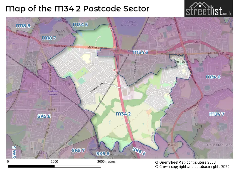
The M34 2 Postcode shares a border with SK5 6 (STOCKPORT, Reddish), SK6 2 (Bredbury), M18 7 (MANCHESTER, Gorton), M34 3 (Denton), M34 5 (Audenshaw), M34 6 (Denton), SK5 7 (STOCKPORT) and SK5 8 (STOCKPORT).
The sector is within the post town of MANCHESTER.
M34 2 is a postcode sector within the M34 postcode district which is within the M Manchester postcode area.
The Royal Mail delivery office for the M34 2 postal sector is the Denton Delivery Office.
The area of the M34 2 postcode sector is 1.49 square miles which is 3.87 square kilometres or 956.70 square acres.
The M34 2 postcode sector is crossed by the M60 motorway.
Waterways within the M34 2 postcode sector include the River Tame.

Map of the M34 2 Postcode Sector
Explore the M34 2 postcode sector by using our free interactive map.
| M | 3 | 4 | - | 2 | X | X |
| M | 3 | 4 | Space | 2 | Letter | Letter |
Official List of Streets
Denton (125 Streets)
Unofficial Streets or Alternative Spellings
Denton
ALBERT STREET BIRCH GROVE CHILLINGTON WALK GABLE COURT MERLYN AVENUE OLDHAM STREET QUEEN STREET STANLEY ROAD STOCKPORT ROAD WESTBOURNE ROAD WILLOW GROVE YEW TREE ROAD ASHBROOK AVE BROOKLAND AVENUE BURNHAM ROAD CHARNWOOD AVE DENTON ROUNDABOUT FELT COURT FRANKLIN CLOSE HARRIS AVE HILLVIEW ROAD HULTON STREET KINGS ROAD RADNOR AVE THOMPSON COURT WILTON COURTMANCHESTER
CARLTON RANGE HYDE ROAD KINGSDALE ROADWeather Forecast for M34 2
Press Button to Show Forecast for Dane Bank
| Time Period | Icon | Description | Temperature | Rain Probability | Wind |
|---|---|---|---|---|---|
| 15:00 to 18:00 | Cloudy | 9.0°C (feels like 8.0°C) | 42.00% | NNW 4 mph | |
| 18:00 to 21:00 | Cloudy | 8.0°C (feels like 7.0°C) | 9.00% | ENE 7 mph | |
| 21:00 to 00:00 | Cloudy | 6.0°C (feels like 4.0°C) | 9.00% | ENE 7 mph |
Press Button to Show Forecast for Dane Bank
| Time Period | Icon | Description | Temperature | Rain Probability | Wind |
|---|---|---|---|---|---|
| 00:00 to 03:00 | Cloudy | 4.0°C (feels like 2.0°C) | 5.00% | ENE 7 mph | |
| 03:00 to 06:00 | Clear night | 3.0°C (feels like 1.0°C) | 1.00% | ENE 4 mph | |
| 06:00 to 09:00 | Sunny day | 3.0°C (feels like 1.0°C) | 1.00% | ENE 4 mph | |
| 09:00 to 12:00 | Partly cloudy (day) | 7.0°C (feels like 5.0°C) | 5.00% | E 4 mph | |
| 12:00 to 15:00 | Overcast | 9.0°C (feels like 8.0°C) | 10.00% | ENE 4 mph | |
| 15:00 to 18:00 | Cloudy | 10.0°C (feels like 9.0°C) | 6.00% | E 4 mph | |
| 18:00 to 21:00 | Cloudy | 9.0°C (feels like 8.0°C) | 6.00% | NE 4 mph | |
| 21:00 to 00:00 | Partly cloudy (night) | 6.0°C (feels like 3.0°C) | 4.00% | ENE 7 mph |
Press Button to Show Forecast for Dane Bank
| Time Period | Icon | Description | Temperature | Rain Probability | Wind |
|---|---|---|---|---|---|
| 00:00 to 03:00 | Partly cloudy (night) | 4.0°C (feels like 2.0°C) | 6.00% | ENE 4 mph | |
| 03:00 to 06:00 | Partly cloudy (night) | 3.0°C (feels like 1.0°C) | 7.00% | ENE 4 mph | |
| 06:00 to 09:00 | Partly cloudy (day) | 4.0°C (feels like 2.0°C) | 6.00% | ENE 4 mph | |
| 09:00 to 12:00 | Partly cloudy (day) | 8.0°C (feels like 6.0°C) | 4.00% | E 7 mph | |
| 12:00 to 15:00 | Overcast | 10.0°C (feels like 8.0°C) | 16.00% | E 9 mph | |
| 15:00 to 18:00 | Light rain | 10.0°C (feels like 8.0°C) | 45.00% | E 9 mph | |
| 18:00 to 21:00 | Cloudy | 9.0°C (feels like 7.0°C) | 15.00% | ENE 9 mph | |
| 21:00 to 00:00 | Cloudy | 7.0°C (feels like 4.0°C) | 14.00% | NE 9 mph |
Press Button to Show Forecast for Dane Bank
| Time Period | Icon | Description | Temperature | Rain Probability | Wind |
|---|---|---|---|---|---|
| 00:00 to 03:00 | Cloudy | 6.0°C (feels like 3.0°C) | 15.00% | NE 9 mph | |
| 03:00 to 06:00 | Cloudy | 6.0°C (feels like 3.0°C) | 15.00% | NE 9 mph | |
| 06:00 to 09:00 | Light rain | 7.0°C (feels like 4.0°C) | 49.00% | NE 9 mph | |
| 09:00 to 12:00 | Light rain | 8.0°C (feels like 5.0°C) | 53.00% | NNE 11 mph | |
| 12:00 to 15:00 | Heavy rain | 9.0°C (feels like 6.0°C) | 77.00% | NNE 11 mph | |
| 15:00 to 18:00 | Heavy rain | 9.0°C (feels like 7.0°C) | 76.00% | NNE 9 mph | |
| 18:00 to 21:00 | Light rain shower (day) | 10.0°C (feels like 8.0°C) | 38.00% | NNE 9 mph | |
| 21:00 to 00:00 | Clear night | 7.0°C (feels like 5.0°C) | 12.00% | NNW 7 mph |
Schools and Places of Education Within the M34 2 Postcode Sector
Denton West End Primary School
Academy converter
Balmoral Drive, Manchester, Lancashire, M34 2JX
Head: Mrs Sharron White
Ofsted Rating: Good
Inspection: 2023-10-11 (197 days ago)
Website: Visit Denton West End Primary School Website
Phone: 01613363409
Number of Pupils: 454
Greswell Primary School and Nursery
Community school
Percy Road, Manchester, , M34 2DH
Head: Mr John Cooper
Ofsted Rating: Good
Inspection: 2023-09-27 (211 days ago)
Website: Visit Greswell Primary School and Nursery Website
Phone: 01613366854
Number of Pupils: 439
St Mary's RC Primary School
Voluntary aided school
Kynder Street, Manchester, , M34 2AR
Head: Mr Neil Price
Ofsted Rating: Outstanding
Inspection: 2013-07-04 (3948 days ago)
Website: Visit St Mary's RC Primary School Website
Phone: 01613363322
Number of Pupils: 230
House Prices in the M34 2 Postcode Sector
| Type of Property | 2018 Average | 2018 Sales | 2017 Average | 2017 Sales | 2016 Average | 2016 Sales | 2015 Average | 2015 Sales |
|---|---|---|---|---|---|---|---|---|
| Detached | £197,333 | 9 | £242,745 | 10 | £196,624 | 8 | £210,333 | 3 |
| Semi-Detached | £181,653 | 121 | £169,649 | 124 | £154,950 | 121 | £147,922 | 117 |
| Terraced | £133,616 | 63 | £141,725 | 48 | £125,794 | 34 | £121,476 | 41 |
| Flats | £102,600 | 5 | £109,250 | 2 | £0 | 0 | £70,000 | 2 |
Important Postcodes M34 2 in the Postcode Sector
M34 2AJ is the postcode for Ann Street Clinic, Ann Street
M34 2AP is the postcode for Denton Town Hall, Market Street
M34 2AR is the postcode for St MaryG��s R.C Primary and Nursery School, Kynder Street, Denton, and St. Marys RC Primary School, Kynder Street
M34 2BW is the postcode for Denton Centre, Acre Street
M34 2DH is the postcode for INFANT BLOCK, Greswell Primary & Nursery School, Percy Road, JUNIOR BLOCK, Greswell Primary School, Percy Road, and JUNIOR BLOCK, Greswell Primary & Nursery School, Percy Road
M34 2GP is the postcode for Millennium House, Progress Way, and Tameside & Glossop Primary Care Trust, New Century House, Progress Way
M34 2JX is the postcode for Denton West End Primary School, Balmoral Drive
| The M34 2 Sector is within these Local Authorities |
|
|---|---|
| The M34 2 Sector is within these Counties |
|
| The M34 2 Sector is within these Water Company Areas |
|