The M35 9 postcode sector is within the county of Greater Manchester.
Did you know? According to the 2021 Census, the M35 9 postcode sector is home to a bustling 9,138 residents!
Given that each sector allows for 400 unique postcode combinations. Letters C, I, K, M, O and V are not allowed in the last two letters of a postcode. With 242 postcodes already in use, this leaves 158 units available.
The M35 9 postal code covers the settlement of Failsworth.
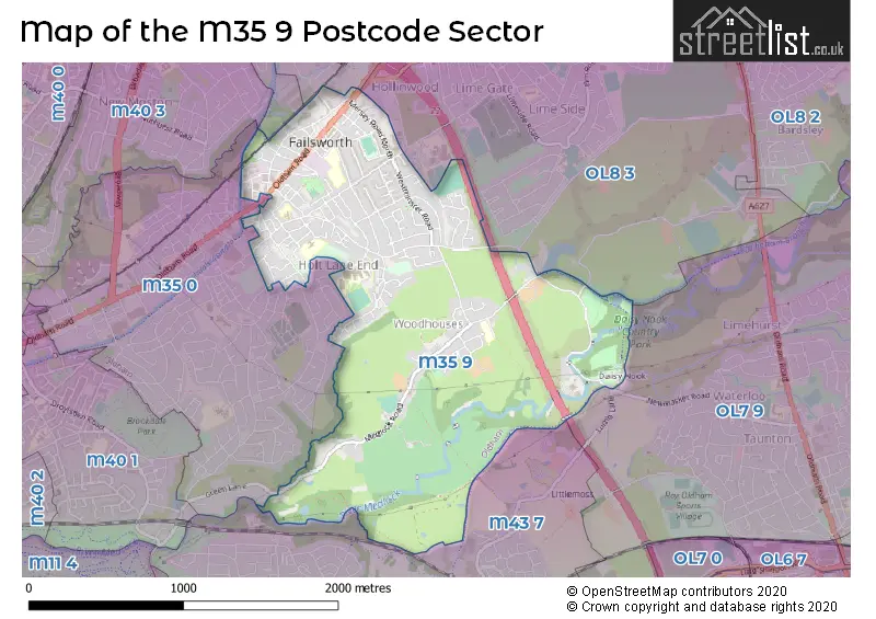
The M35 9 Postcode shares a border with OL9 7 (OLDHAM, Chadderton), M35 0 (Failsworth), M40 3 (MANCHESTER, New Moston), M43 7 (Droylsden), OL7 9 (ASHTON-UNDER-LYNE), OL8 3 (OLDHAM) and OL9 8 (Chadderton).
The sector is within the post town of MANCHESTER.
M35 9 is a postcode sector within the M35 postcode district which is within the M Manchester postcode area.
The Royal Mail delivery office for the M35 9 postal sector is the Failsworth Delivery Office.
The area of the M35 9 postcode sector is 1.54 square miles which is 4.00 square kilometres or 988.74 square acres.
The M35 9 postcode sector is crossed by the M60 motorway.
Waterways within the M35 9 postcode sector include the River Medlock, Rochdale Canal.

Map of the M35 9 Postcode Sector
Explore the M35 9 postcode sector by using our free interactive map.
| M | 3 | 5 | - | 9 | X | X |
| M | 3 | 5 | Space | 9 | Letter | Letter |
Official List of Streets
Failsworth (147 Streets)
Unofficial Streets or Alternative Spellings
Failsworth
CO-OPERATION STREET GREEN LANE LAYCOCK CRESCENT BACK WILLIAM STREET CRIME LANE CROFT STREET GLADEWOOD DRIVE GORE AVENUE HENRY STREET PEACE STREET SAINT JOHNS GARDENS STANNYBROOK ROAD WAGSTAFFE DRIVEHawksley Industrial Estate
MANCHESTER ROADWeather Forecast for M35 9
Press Button to Show Forecast for Failsworth
| Time Period | Icon | Description | Temperature | Rain Probability | Wind |
|---|---|---|---|---|---|
| 15:00 to 18:00 | Cloudy | 9.0°C (feels like 8.0°C) | 7.00% | ENE 4 mph | |
| 18:00 to 21:00 | Cloudy | 8.0°C (feels like 6.0°C) | 6.00% | NE 7 mph | |
| 21:00 to 00:00 | Cloudy | 6.0°C (feels like 4.0°C) | 6.00% | ENE 7 mph |
Press Button to Show Forecast for Failsworth
| Time Period | Icon | Description | Temperature | Rain Probability | Wind |
|---|---|---|---|---|---|
| 00:00 to 03:00 | Partly cloudy (night) | 4.0°C (feels like 2.0°C) | 2.00% | ENE 4 mph | |
| 03:00 to 06:00 | Clear night | 3.0°C (feels like 1.0°C) | 1.00% | NE 4 mph | |
| 06:00 to 09:00 | Sunny day | 3.0°C (feels like 1.0°C) | 1.00% | NE 4 mph | |
| 09:00 to 12:00 | Partly cloudy (day) | 7.0°C (feels like 5.0°C) | 5.00% | ENE 4 mph | |
| 12:00 to 15:00 | Overcast | 9.0°C (feels like 8.0°C) | 10.00% | ENE 4 mph | |
| 15:00 to 18:00 | Cloudy | 10.0°C (feels like 9.0°C) | 6.00% | E 2 mph | |
| 18:00 to 21:00 | Cloudy | 9.0°C (feels like 8.0°C) | 7.00% | ENE 4 mph | |
| 21:00 to 00:00 | Partly cloudy (night) | 6.0°C (feels like 3.0°C) | 4.00% | ENE 7 mph |
Press Button to Show Forecast for Failsworth
| Time Period | Icon | Description | Temperature | Rain Probability | Wind |
|---|---|---|---|---|---|
| 00:00 to 03:00 | Partly cloudy (night) | 4.0°C (feels like 1.0°C) | 6.00% | ENE 7 mph | |
| 03:00 to 06:00 | Partly cloudy (night) | 3.0°C (feels like 1.0°C) | 7.00% | ENE 4 mph | |
| 06:00 to 09:00 | Partly cloudy (day) | 5.0°C (feels like 3.0°C) | 6.00% | ENE 4 mph | |
| 09:00 to 12:00 | Cloudy | 8.0°C (feels like 6.0°C) | 7.00% | E 7 mph | |
| 12:00 to 15:00 | Overcast | 10.0°C (feels like 8.0°C) | 16.00% | E 9 mph | |
| 15:00 to 18:00 | Light rain | 10.0°C (feels like 8.0°C) | 45.00% | E 9 mph | |
| 18:00 to 21:00 | Cloudy | 10.0°C (feels like 8.0°C) | 15.00% | ENE 9 mph | |
| 21:00 to 00:00 | Cloudy | 7.0°C (feels like 4.0°C) | 14.00% | NE 9 mph |
Press Button to Show Forecast for Failsworth
| Time Period | Icon | Description | Temperature | Rain Probability | Wind |
|---|---|---|---|---|---|
| 00:00 to 03:00 | Cloudy | 6.0°C (feels like 3.0°C) | 15.00% | NE 9 mph | |
| 03:00 to 06:00 | Cloudy | 6.0°C (feels like 3.0°C) | 16.00% | NE 11 mph | |
| 06:00 to 09:00 | Light rain | 7.0°C (feels like 4.0°C) | 49.00% | NE 11 mph | |
| 09:00 to 12:00 | Light rain | 8.0°C (feels like 5.0°C) | 50.00% | NE 11 mph | |
| 12:00 to 15:00 | Light rain | 9.0°C (feels like 7.0°C) | 56.00% | NNE 9 mph | |
| 15:00 to 18:00 | Heavy rain | 9.0°C (feels like 7.0°C) | 74.00% | NNE 9 mph | |
| 18:00 to 21:00 | Light rain shower (day) | 10.0°C (feels like 8.0°C) | 38.00% | NNE 7 mph | |
| 21:00 to 00:00 | Clear night | 7.0°C (feels like 5.0°C) | 11.00% | SSE 7 mph |
Schools and Places of Education Within the M35 9 Postcode Sector
Co-op Academy Failsworth
Academy sponsor led
Brierley Avenue, Manchester, , M35 9HA
Head: Mr Phillip Quirk
Ofsted Rating: Requires improvement
Inspection: 2021-12-09 (868 days ago)
Website: Visit Co-op Academy Failsworth Website
Phone: 01616883900
Number of Pupils: 1453
Higher Failsworth Primary School
Community school
Stansfield Road, Oldham, Greater Manchester, M35 9EA
Head: Mrs Samantha Forster
Ofsted Rating: Good
Inspection: 2023-02-09 (441 days ago)
Website: Visit Higher Failsworth Primary School Website
Phone: 01616812645
Number of Pupils: 426
SMS Changing Lives School
Other independent special school
Ferranti House, Manchester, Greater Manchester, M35 9AY
Head: Ms Hecabe DuFraisse
Ofsted Rating: Good
Inspection: 2022-11-17 (525 days ago)
Website: Visit SMS Changing Lives School Website
Phone: 01616826462
Number of Pupils: 33
St John's Church of England Primary School
Academy sponsor led
St Johns C of E Primary School, James Street, Manchester, Lancashire, M35 9PY
Head: Miss Louise Bonter
Ofsted Rating: Good
Inspection: 2023-04-26 (365 days ago)
Website: Visit St John's Church of England Primary School Website
Phone: 01616948096
Number of Pupils: 269
Woodhouses Voluntary Primary School
Voluntary controlled school
Ashton Road, Manchester, , M35 9WL
Head: Mrs Helen Woodward
Ofsted Rating: Good
Inspection: 2021-10-13 (925 days ago)
Website: Visit Woodhouses Voluntary Primary School Website
Phone: 01616816793
Number of Pupils: 130
House Prices in the M35 9 Postcode Sector
| Type of Property | 2018 Average | 2018 Sales | 2017 Average | 2017 Sales | 2016 Average | 2016 Sales | 2015 Average | 2015 Sales |
|---|---|---|---|---|---|---|---|---|
| Detached | £267,816 | 14 | £313,011 | 22 | £229,584 | 31 | £232,938 | 29 |
| Semi-Detached | £155,478 | 54 | £139,987 | 63 | £138,735 | 72 | £129,686 | 42 |
| Terraced | £124,993 | 69 | £115,395 | 90 | £107,324 | 80 | £107,330 | 65 |
| Flats | £90,150 | 5 | £83,279 | 7 | £87,400 | 5 | £80,714 | 7 |
Important Postcodes M35 9 in the Postcode Sector
M35 9AD is the postcode for Ena Hughes Resource Centre, 2 Ellesmere Street
M35 9EA is the postcode for Higher Failsworth Primary School, Stansfield Road
M35 9HA is the postcode for Failsworth Pool, Brierley Avenue, FAILSWORTH SPORTS CENTRE, BRIERLEY AVENUE, FAILSWORTH, Failsworth School, Brierley Avenue, Oldham Community Leisure Ltd, Failsworth Sports Centre, Brierley Avenue, Failsworth Sports Centre, Brierley Avenue, and Failsworth School, Brierley Avenue, Failsworth
M35 9PN is the postcode for St. John's C of E Primary School Nursery/Infant Site, Ashton Road East
M35 9PY is the postcode for St. Johns C of E Primary School Junior Site, James Street
M35 9WL is the postcode for Woodhouses Voluntary Controlled C of E and Free Church Primary School, Ashton Road
| The M35 9 Sector is within these Local Authorities |
|
|---|---|
| The M35 9 Sector is within these Counties |
|
| The M35 9 Sector is within these Water Company Areas |
|