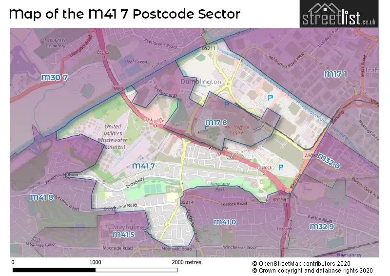
The M41 7 postcode sector is within the county of Greater Manchester.
Did you know? According to the 2021 Census, the M41 7 postcode sector is home to a bustling 5,740 residents!
Given that each sector allows for 400 unique postcode combinations. Letters C, I, K, M, O and V are not allowed in the last two letters of a postcode. With 144 postcodes already in use, this leaves 256 units available.
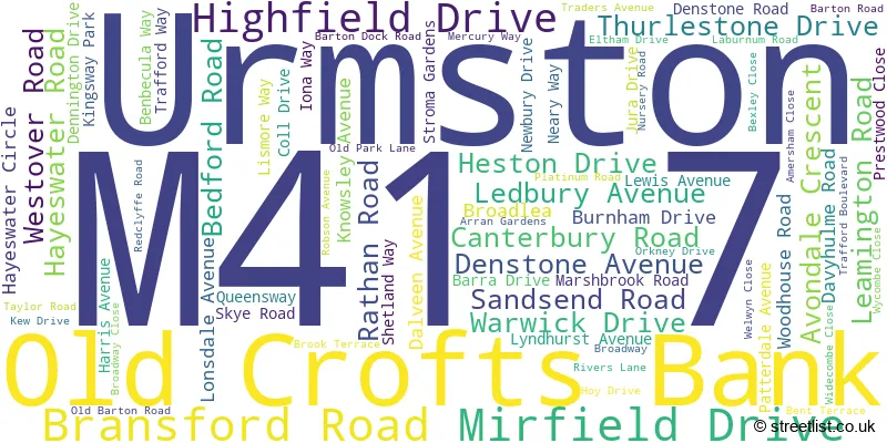
The M41 7 postal code covers the settlement of Urmston.
The M41 7 Postcode shares a border with M17 8 (The Trafford Centre, MANCHESTER), M32 9 (Stretford), M17 1 (Trafford Park), M41 5 (Urmston), M30 0 (Eccles), M30 7 (Eccles), M32 0 (Stretford), M41 0 (Urmston) and M41 8 (Urmston).
The sector is within the post town of MANCHESTER.
M41 7 is a postcode sector within the M41 postcode district which is within the M Manchester postcode area.
The Royal Mail delivery office for the M41 7 postal sector is the Urmston Delivery Office.
The area of the M41 7 postcode sector is 1.38 square miles which is 3.59 square kilometres or 885.95 square acres.
The M41 7 postcode sector is crossed by the M60 motorway.
Waterways within the M41 7 postcode sector include the Bridgewater Canal, Manchester Ship Canal.

Map of the M41 7 Postcode Sector
Explore the M41 7 postcode sector by using our free interactive map.
| M | 4 | 1 | - | 7 | X | X |
| M | 4 | 1 | Space | 7 | Letter | Letter |
Official List of Streets
Urmston (73 Streets)
Unofficial Streets or Alternative Spellings
Stretford
BARTON DOCK ROAD BARTON ROADUrmston
BALMAIN ROAD BENT LANES BOWERS AVENUE CORNHILL ROAD CROFTS BANK ROAD ENTWISLE AVENUE FILEY AVENUE GUILDFORD ROAD ILKLEY DRIVE LOSTOCK ROAD MOORLANDS AVENUE REDCAR AVENUE ROSSETT DRIVE SANDGATE DRIVE SELBY DRIVE BARTON HIGH LEVEL BRIDGE BARTON ROAD BRIDGE BENDEMEER BRIDGEWATER CIRCLE BRIGHT CIRCLE CHAPEL PLACE COBALT AVENUE CROFTS BANK BRIDGE ELLESMERE CIRCLE LOSTOCK CIRCLE PARK WAY PEEL AVENUE PHOENIX WAY REDCLYFFE CIRCLE SALFORD WESTERN GATEWAY SHETLAND CIRCLE SOUTH AVENUE STRETFORD-ECCLES BY-PASS TRAFFORD RETAIL PARK WEST ROAD WOODBANK COURT WOODLANDSTrafford Park
ASHBURTON ROAD WEST TWINING ROADWeather Forecast for M41 7
Press Button to Show Forecast for Crofts Bank
| Time Period | Icon | Description | Temperature | Rain Probability | Wind |
|---|---|---|---|---|---|
| 06:00 to 09:00 | Partly cloudy (day) | 7.0°C (feels like 3.0°C) | 1.00% | NW 13 mph | |
| 09:00 to 12:00 | Partly cloudy (day) | 9.0°C (feels like 6.0°C) | 4.00% | NNW 13 mph | |
| 12:00 to 15:00 | Partly cloudy (day) | 11.0°C (feels like 8.0°C) | 2.00% | NNW 13 mph | |
| 15:00 to 18:00 | Cloudy | 11.0°C (feels like 8.0°C) | 32.00% | NW 16 mph | |
| 18:00 to 21:00 | Sunny day | 9.0°C (feels like 6.0°C) | 3.00% | NW 13 mph | |
| 21:00 to 00:00 | Light rain shower (night) | 7.0°C (feels like 4.0°C) | 38.00% | NW 11 mph |
Press Button to Show Forecast for Crofts Bank
| Time Period | Icon | Description | Temperature | Rain Probability | Wind |
|---|---|---|---|---|---|
| 00:00 to 03:00 | Light rain shower (night) | 6.0°C (feels like 2.0°C) | 34.00% | NW 11 mph | |
| 03:00 to 06:00 | Clear night | 4.0°C (feels like 1.0°C) | 33.00% | NW 11 mph | |
| 06:00 to 09:00 | Sunny day | 4.0°C (feels like 1.0°C) | 34.00% | NW 11 mph | |
| 09:00 to 12:00 | Cloudy | 8.0°C (feels like 4.0°C) | 8.00% | NW 16 mph | |
| 12:00 to 15:00 | Cloudy | 9.0°C (feels like 6.0°C) | 9.00% | NW 16 mph | |
| 15:00 to 18:00 | Cloudy | 10.0°C (feels like 7.0°C) | 10.00% | NW 13 mph | |
| 18:00 to 21:00 | Partly cloudy (day) | 9.0°C (feels like 7.0°C) | 2.00% | NNW 9 mph | |
| 21:00 to 00:00 | Clear night | 6.0°C (feels like 4.0°C) | 4.00% | N 7 mph |
Press Button to Show Forecast for Crofts Bank
| Time Period | Icon | Description | Temperature | Rain Probability | Wind |
|---|---|---|---|---|---|
| 00:00 to 03:00 | Clear night | 4.0°C (feels like 2.0°C) | 3.00% | N 4 mph | |
| 03:00 to 06:00 | Partly cloudy (night) | 3.0°C (feels like 1.0°C) | 4.00% | NNW 4 mph | |
| 06:00 to 09:00 | Partly cloudy (day) | 4.0°C (feels like 2.0°C) | 4.00% | NNW 2 mph | |
| 09:00 to 12:00 | Cloudy | 8.0°C (feels like 7.0°C) | 10.00% | SW 4 mph | |
| 12:00 to 15:00 | Cloudy | 11.0°C (feels like 9.0°C) | 13.00% | W 7 mph | |
| 15:00 to 18:00 | Cloudy | 11.0°C (feels like 9.0°C) | 16.00% | W 11 mph | |
| 18:00 to 21:00 | Cloudy | 10.0°C (feels like 7.0°C) | 19.00% | W 11 mph | |
| 21:00 to 00:00 | Overcast | 9.0°C (feels like 6.0°C) | 20.00% | W 11 mph |
Press Button to Show Forecast for Crofts Bank
| Time Period | Icon | Description | Temperature | Rain Probability | Wind |
|---|---|---|---|---|---|
| 00:00 to 03:00 | Overcast | 9.0°C (feels like 6.0°C) | 13.00% | W 13 mph | |
| 03:00 to 06:00 | Cloudy | 9.0°C (feels like 6.0°C) | 11.00% | WNW 13 mph | |
| 06:00 to 09:00 | Overcast | 9.0°C (feels like 6.0°C) | 11.00% | WNW 13 mph | |
| 09:00 to 12:00 | Cloudy | 10.0°C (feels like 7.0°C) | 9.00% | NW 16 mph | |
| 12:00 to 15:00 | Cloudy | 12.0°C (feels like 8.0°C) | 9.00% | NW 18 mph | |
| 15:00 to 18:00 | Partly cloudy (day) | 12.0°C (feels like 9.0°C) | 5.00% | NW 18 mph | |
| 18:00 to 21:00 | Sunny day | 11.0°C (feels like 8.0°C) | 4.00% | NW 13 mph | |
| 21:00 to 00:00 | Partly cloudy (night) | 9.0°C (feels like 7.0°C) | 1.00% | NNW 9 mph |
Schools and Places of Education Within the M41 7 Postcode Sector
Egerton High School
Community special school
Kingsway Park, Manchester, , M41 7FZ
Head: Mr John Madden
Ofsted Rating: Good
Inspection: 2021-09-15 (944 days ago)
Website: Visit Egerton High School Website
Phone: 01617497094
Number of Pupils: 55
Our Lady of the Rosary RC Primary School
Voluntary aided school
Davyhulme Road, Manchester, , M41 7DS
Head: Ms Susan Molloy
Ofsted Rating: Good
Inspection: 2021-10-20 (909 days ago)
Website: Visit Our Lady of the Rosary RC Primary School Website
Phone: 01617484626
Number of Pupils: 235
Woodhouse Primary School
Community school
Nursery Road, Manchester, , M41 7WW
Head: Mrs Julie O'Connor
Ofsted Rating: Good
Inspection: 2023-04-20 (362 days ago)
Website: Visit Woodhouse Primary School Website
Phone: 01617485844
Number of Pupils: 234
House Prices in the M41 7 Postcode Sector
| Type of Property | 2018 Average | 2018 Sales | 2017 Average | 2017 Sales | 2016 Average | 2016 Sales | 2015 Average | 2015 Sales |
|---|---|---|---|---|---|---|---|---|
| Detached | £312,091 | 11 | £294,318 | 11 | £262,782 | 14 | £275,350 | 10 |
| Semi-Detached | £222,657 | 62 | £229,200 | 59 | £206,678 | 57 | £184,466 | 60 |
| Terraced | £187,736 | 21 | £176,678 | 14 | £152,998 | 23 | £146,767 | 26 |
| Flats | £128,125 | 4 | £138,700 | 5 | £135,625 | 4 | £112,200 | 7 |
Important Postcodes M41 7 in the Postcode Sector
M41 7DS is the postcode for Our Lady of the Rosary RC School, Davyhulme Road
M41 7FJ is the postcode for Be Active Urmston, Kingsway Park, GEORGE H CARNALL LEISURE CENTRE, KINGSWAY PARK, DAVYHULME, and George H Carnall Leisure Centre, Kingsway Park
M41 7FZ is the postcode for Egerton High School, Kingsway Park, Urmston, and Egerton High School, Kingsway Park
M41 7NL is the postcode for Katherine Lowe Home, Barton Road
M41 7WJ is the postcode for Davyhulme Medical Centre, 130 Broadway
M41 7WW is the postcode for WOODHOUSE PRIMARY SCHOOL, NURSERY ROAD, DAVYHULME
| The M41 7 Sector is within these Local Authorities |
|
|---|---|
| The M41 7 Sector is within these Counties |
|
| The M41 7 Sector is within these Water Company Areas |
|