The M43 7 postcode sector is within the county of Greater Manchester.
Did you know? According to the 2021 Census, the M43 7 postcode sector is home to a bustling 13,801 residents!
Given that each sector allows for 400 unique postcode combinations. Letters C, I, K, M, O and V are not allowed in the last two letters of a postcode. With 337 postcodes already in use, this leaves 63 units available.
The M43 7 postal code covers the settlement of Droylsden.
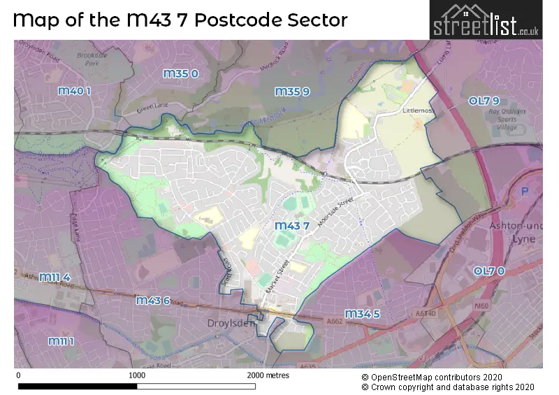
The M43 7 Postcode shares a border with OL7 0 (ASHTON-UNDER-LYNE), M11 4 (MANCHESTER, Openshaw, Clayton), M34 5 (Audenshaw), M35 0 (Failsworth), M35 9 (Failsworth), M43 6 (Droylsden), OL7 9 (ASHTON-UNDER-LYNE) and M40 1 (MANCHESTER, Newton Heath).
The sector is within the post town of MANCHESTER.
M43 7 is a postcode sector within the M43 postcode district which is within the M Manchester postcode area.
The Royal Mail delivery office for the M43 7 postal sector is the Droylsden Delivery Office.
The area of the M43 7 postcode sector is 1.30 square miles which is 3.38 square kilometres or 834.23 square acres.
The M43 7 postcode sector is crossed by the M60 motorway.
Waterways within the M43 7 postcode sector include the River Medlock.

Map of the M43 7 Postcode Sector
Explore the M43 7 postcode sector by using our free interactive map.
| M | 4 | 3 | - | 7 | X | X |
| M | 4 | 3 | Space | 7 | Letter | Letter |
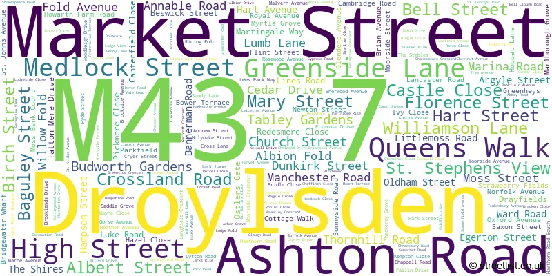
Official List of Streets
Droylsden (211 Streets)
Unofficial Streets or Alternative Spellings
Droylsden
EDGE LANE KINGS WALK LUNE WALK MASEFIELD ROAD TAYLOR STREET TRENT WALK AUDENSHAW RAILWAY CYCLE PATH BULLER STREET CAMPBELL STREET CHAPEL STREET CLOCK HOUSE AVENUE CLOCKHOUSE MEWS FITZROY STREET HENRY STREET HOBSON WAY HOLLY BANK HOLLYBANK CLOSE LEES STREET MEADOW VIEW MERCER STREET PERCIVAL ROAD ROBERTSONS WAY SCHOFIELD ROAD SUNNYSIDE COURT SUNNYSIDE LANEAudenshaw
DROYLSDEN ROADASHTON-UNDER-LYNE
BACK LANEWeather Forecast for M43 7
Press Button to Show Forecast for Droylsden
| Time Period | Icon | Description | Temperature | Rain Probability | Wind |
|---|---|---|---|---|---|
| 12:00 to 15:00 | Light rain | 8.0°C (feels like 6.0°C) | 50.00% | N 4 mph | |
| 15:00 to 18:00 | Cloudy | 9.0°C (feels like 8.0°C) | 6.00% | N 4 mph | |
| 18:00 to 21:00 | Cloudy | 8.0°C (feels like 6.0°C) | 7.00% | NE 7 mph | |
| 21:00 to 00:00 | Cloudy | 6.0°C (feels like 4.0°C) | 8.00% | ENE 7 mph |
Press Button to Show Forecast for Droylsden
| Time Period | Icon | Description | Temperature | Rain Probability | Wind |
|---|---|---|---|---|---|
| 00:00 to 03:00 | Cloudy | 4.0°C (feels like 2.0°C) | 6.00% | ENE 4 mph | |
| 03:00 to 06:00 | Clear night | 3.0°C (feels like 1.0°C) | 1.00% | NE 4 mph | |
| 06:00 to 09:00 | Sunny day | 3.0°C (feels like 1.0°C) | 1.00% | ENE 4 mph | |
| 09:00 to 12:00 | Sunny day | 7.0°C (feels like 5.0°C) | 2.00% | ENE 4 mph | |
| 12:00 to 15:00 | Overcast | 9.0°C (feels like 8.0°C) | 9.00% | ENE 4 mph | |
| 15:00 to 18:00 | Cloudy | 10.0°C (feels like 9.0°C) | 6.00% | ESE 4 mph | |
| 18:00 to 21:00 | Cloudy | 9.0°C (feels like 8.0°C) | 6.00% | ENE 4 mph | |
| 21:00 to 00:00 | Partly cloudy (night) | 6.0°C (feels like 3.0°C) | 4.00% | ENE 7 mph |
Press Button to Show Forecast for Droylsden
| Time Period | Icon | Description | Temperature | Rain Probability | Wind |
|---|---|---|---|---|---|
| 00:00 to 03:00 | Partly cloudy (night) | 4.0°C (feels like 2.0°C) | 6.00% | ENE 4 mph | |
| 03:00 to 06:00 | Partly cloudy (night) | 3.0°C (feels like 1.0°C) | 7.00% | ENE 4 mph | |
| 06:00 to 09:00 | Partly cloudy (day) | 5.0°C (feels like 3.0°C) | 6.00% | ENE 7 mph | |
| 09:00 to 12:00 | Cloudy | 8.0°C (feels like 6.0°C) | 7.00% | E 7 mph | |
| 12:00 to 15:00 | Overcast | 10.0°C (feels like 8.0°C) | 16.00% | E 9 mph | |
| 15:00 to 18:00 | Light rain | 10.0°C (feels like 8.0°C) | 45.00% | E 9 mph | |
| 18:00 to 21:00 | Cloudy | 10.0°C (feels like 8.0°C) | 15.00% | ENE 9 mph | |
| 21:00 to 00:00 | Cloudy | 7.0°C (feels like 4.0°C) | 14.00% | NE 9 mph |
Press Button to Show Forecast for Droylsden
| Time Period | Icon | Description | Temperature | Rain Probability | Wind |
|---|---|---|---|---|---|
| 00:00 to 03:00 | Cloudy | 6.0°C (feels like 3.0°C) | 15.00% | NE 9 mph | |
| 03:00 to 06:00 | Cloudy | 6.0°C (feels like 3.0°C) | 15.00% | NE 11 mph | |
| 06:00 to 09:00 | Light rain | 7.0°C (feels like 4.0°C) | 49.00% | NE 11 mph | |
| 09:00 to 12:00 | Light rain | 8.0°C (feels like 5.0°C) | 50.00% | NE 11 mph | |
| 12:00 to 15:00 | Light rain | 9.0°C (feels like 7.0°C) | 56.00% | NNE 9 mph | |
| 15:00 to 18:00 | Heavy rain | 9.0°C (feels like 7.0°C) | 74.00% | NNE 9 mph | |
| 18:00 to 21:00 | Light rain shower (day) | 10.0°C (feels like 8.0°C) | 38.00% | NNE 7 mph | |
| 21:00 to 00:00 | Clear night | 7.0°C (feels like 5.0°C) | 11.00% | SSE 7 mph |
Schools and Places of Education Within the M43 7 Postcode Sector
Greenside Primary School
Academy converter
Greenside Lane, Manchester, , M43 7RA
Head: Mrs Judith Reynolds
Ofsted Rating: Good
Inspection: 2023-01-26 (455 days ago)
Website: Visit Greenside Primary School Website
Phone: 01613708496
Number of Pupils: 472
Laurus Ryecroft
Free schools
Lumb Lane, Manchester, , M43 7LJ
Head: Mr Reece Carling
Ofsted Rating: Outstanding
Inspection: 2023-01-26 (455 days ago)
Website: Visit Laurus Ryecroft Website
Phone: 01615075500
Number of Pupils: 952
Moorside Primary School
Academy converter
Market Street, Manchester, , M43 7DA
Head: Mr Sam Ismail
Ofsted Rating: Good
Inspection: 2018-11-28 (1975 days ago)
Website: Visit Moorside Primary School Website
Phone: 01613703614
Number of Pupils: 442
St Mary's CofE Primary School
Voluntary aided school
Church Street, Manchester, , M43 7BR
Head: Mr Christopher Quinn
Ofsted Rating: Good
Inspection: 2018-06-13 (2143 days ago)
Website: Visit St Mary's CofE Primary School Website
Phone: 01613703948
Number of Pupils: 228
St Stephen's RC Primary School
Voluntary aided school
Chappell Road, Manchester, , M43 7NA
Head: Mr Connor Lavin
Ofsted Rating: Good
Inspection: 2022-04-27 (729 days ago)
Website: Visit St Stephen's RC Primary School Website
Phone: 01613702071
Number of Pupils: 410
House Prices in the M43 7 Postcode Sector
| Type of Property | 2018 Average | 2018 Sales | 2017 Average | 2017 Sales | 2016 Average | 2016 Sales | 2015 Average | 2015 Sales |
|---|---|---|---|---|---|---|---|---|
| Detached | £225,208 | 19 | £210,113 | 31 | £207,033 | 23 | £179,010 | 21 |
| Semi-Detached | £134,255 | 109 | £134,738 | 99 | £119,461 | 74 | £121,414 | 77 |
| Terraced | £129,719 | 103 | £128,447 | 116 | £106,388 | 70 | £94,979 | 65 |
| Flats | £118,041 | 59 | £67,250 | 4 | £78,415 | 4 | £72,500 | 4 |
Important Postcodes M43 7 in the Postcode Sector
M43 7BR is the postcode for St. Marys Primary & Nursery School, Church Street, and ST MARYS CHURCH OF ENGLAND PRIMARY SCHOOL, CHURCH STREET, DROYLSDEN
M43 7BW is the postcode for 58, Ashton Road, Droylsden
M43 7DA is the postcode for Moorside Primary School, Market Street, and Moorside Primary School, Market Street, Droylsden
M43 7LF is the postcode for Littlemoss High School, Cryer Street
M43 7NA is the postcode for St. Stephens RC School, Chappell Road
M43 7NP is the postcode for Albion Drive Clinic, 1-3 Albion Drive
M43 7RA is the postcode for Greenside Childrens Centre, Greenside Lane, and Greenside Primary School, Greenside Lane
M43 7XU is the postcode for Our Kids Eyes, Jubilee Gardens, Gardenfold Way, Adventure Medlock, Gardenfold Way, and Active Medlock, Gardenfold Way, Droylsden
| The M43 7 Sector is within these Local Authorities |
|
|---|---|
| The M43 7 Sector is within these Counties |
|
| The M43 7 Sector is within these Water Company Areas |
|