The M45 6 postcode sector is within the county of Greater Manchester.
Did you know? According to the 2021 Census, the M45 6 postcode sector is home to a bustling 6,039 residents!
Given that each sector allows for 400 unique postcode combinations. Letters C, I, K, M, O and V are not allowed in the last two letters of a postcode. With 133 postcodes already in use, this leaves 267 units available.
The M45 6 postal code covers the settlement of Whitefield.
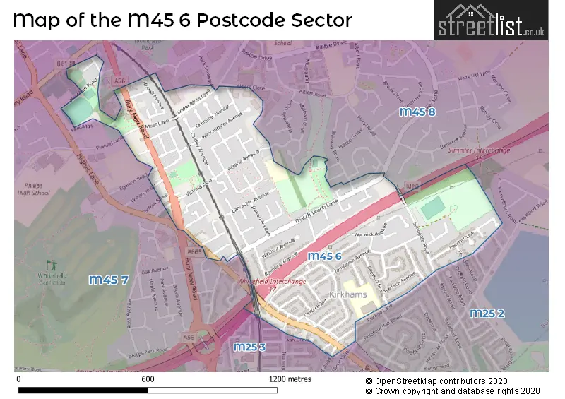
The M45 6 Postcode shares a border with M25 3 (Prestwich), M25 2 (Prestwich), M45 7 (Whitefield) and M45 8 (Whitefield).
The sector is within the post town of MANCHESTER.
M45 6 is a postcode sector within the M45 postcode district which is within the M Manchester postcode area.
The Royal Mail delivery office for the M45 6 postal sector is the Prestwich Delivery Office.
The area of the M45 6 postcode sector is 0.43 square miles which is 1.12 square kilometres or 277.19 square acres.
The M45 6 postcode sector is crossed by the M60 motorway.
The M45 6 postcode sector is crossed by the M62 motorway.

Map of the M45 6 Postcode Sector
Explore the M45 6 postcode sector by using our free interactive map.
| M | 4 | 5 | - | 6 | X | X |
| M | 4 | 5 | Space | 6 | Letter | Letter |
Official List of Streets
Whitefield (87 Streets)
Unofficial Streets or Alternative Spellings
Whitefield
ALBERT CLOSE CONWAY AVENUE EGERTON ROAD HIGHER LANE LONDON STREET OAK BANK CLOSE OAK LANE OXBOW WAY PINFOLD LANE SEFTON STREET STANWAY ROAD WILTON STREET BARN STREET BILL LANE HEAP STREET PARK SEVENTEEN SALISBURY ROAD SALISBURY STREETPrestwich
ASH GROVE BURY NEW ROAD BURY OLD ROAD CUCKOO LANE FERNDENE ROAD GUEST ROAD LILAC GROVE NURSERY ROAD SUNNYFIELD ROADWeather Forecast for M45 6
Press Button to Show Forecast for Whitefield
| Time Period | Icon | Description | Temperature | Rain Probability | Wind |
|---|---|---|---|---|---|
| 03:00 to 06:00 | Clear night | 5.0°C (feels like 3.0°C) | 0.00% | NNE 7 mph | |
| 06:00 to 09:00 | Sunny day | 4.0°C (feels like 2.0°C) | 0.00% | NNE 7 mph | |
| 09:00 to 12:00 | Partly cloudy (day) | 6.0°C (feels like 4.0°C) | 0.00% | N 9 mph | |
| 12:00 to 15:00 | Cloudy | 9.0°C (feels like 7.0°C) | 4.00% | N 7 mph | |
| 15:00 to 18:00 | Cloudy | 11.0°C (feels like 9.0°C) | 4.00% | NNW 9 mph | |
| 18:00 to 21:00 | Sunny day | 9.0°C (feels like 7.0°C) | 0.00% | NW 9 mph | |
| 21:00 to 00:00 | Cloudy | 7.0°C (feels like 5.0°C) | 3.00% | NNW 4 mph |
Press Button to Show Forecast for Whitefield
| Time Period | Icon | Description | Temperature | Rain Probability | Wind |
|---|---|---|---|---|---|
| 00:00 to 03:00 | Partly cloudy (night) | 5.0°C (feels like 4.0°C) | 1.00% | W 4 mph | |
| 03:00 to 06:00 | Partly cloudy (night) | 5.0°C (feels like 3.0°C) | 2.00% | W 4 mph | |
| 06:00 to 09:00 | Cloudy | 6.0°C (feels like 4.0°C) | 6.00% | WNW 7 mph | |
| 09:00 to 12:00 | Partly cloudy (day) | 8.0°C (feels like 6.0°C) | 4.00% | NW 9 mph | |
| 12:00 to 15:00 | Cloudy | 10.0°C (feels like 8.0°C) | 7.00% | NW 9 mph | |
| 15:00 to 18:00 | Cloudy | 9.0°C (feels like 7.0°C) | 8.00% | NNW 9 mph | |
| 18:00 to 21:00 | Cloudy | 8.0°C (feels like 7.0°C) | 7.00% | N 7 mph | |
| 21:00 to 00:00 | Light rain shower (night) | 7.0°C (feels like 5.0°C) | 39.00% | ENE 7 mph |
Press Button to Show Forecast for Whitefield
| Time Period | Icon | Description | Temperature | Rain Probability | Wind |
|---|---|---|---|---|---|
| 00:00 to 03:00 | Overcast | 5.0°C (feels like 3.0°C) | 10.00% | E 4 mph | |
| 03:00 to 06:00 | Cloudy | 4.0°C (feels like 2.0°C) | 7.00% | E 4 mph | |
| 06:00 to 09:00 | Cloudy | 4.0°C (feels like 2.0°C) | 16.00% | E 4 mph | |
| 09:00 to 12:00 | Cloudy | 7.0°C (feels like 5.0°C) | 17.00% | ESE 7 mph | |
| 12:00 to 15:00 | Overcast | 8.0°C (feels like 7.0°C) | 13.00% | ESE 7 mph | |
| 15:00 to 18:00 | Overcast | 10.0°C (feels like 8.0°C) | 15.00% | SE 7 mph | |
| 18:00 to 21:00 | Overcast | 9.0°C (feels like 7.0°C) | 12.00% | E 7 mph | |
| 21:00 to 00:00 | Cloudy | 8.0°C (feels like 5.0°C) | 9.00% | ENE 9 mph |
Press Button to Show Forecast for Whitefield
| Time Period | Icon | Description | Temperature | Rain Probability | Wind |
|---|---|---|---|---|---|
| 00:00 to 03:00 | Overcast | 6.0°C (feels like 4.0°C) | 13.00% | ENE 7 mph | |
| 03:00 to 06:00 | Cloudy | 6.0°C (feels like 3.0°C) | 13.00% | E 7 mph | |
| 06:00 to 09:00 | Cloudy | 6.0°C (feels like 3.0°C) | 14.00% | ENE 7 mph | |
| 09:00 to 12:00 | Cloudy | 8.0°C (feels like 6.0°C) | 12.00% | E 9 mph | |
| 12:00 to 15:00 | Overcast | 10.0°C (feels like 8.0°C) | 15.00% | E 11 mph | |
| 15:00 to 18:00 | Overcast | 11.0°C (feels like 9.0°C) | 18.00% | ENE 11 mph | |
| 18:00 to 21:00 | Cloudy | 10.0°C (feels like 8.0°C) | 12.00% | NE 9 mph | |
| 21:00 to 00:00 | Cloudy | 9.0°C (feels like 6.0°C) | 13.00% | NE 9 mph |
House Prices in the M45 6 Postcode Sector
| Type of Property | 2018 Average | 2018 Sales | 2017 Average | 2017 Sales | 2016 Average | 2016 Sales | 2015 Average | 2015 Sales |
|---|---|---|---|---|---|---|---|---|
| Detached | £281,556 | 9 | £236,444 | 9 | £237,500 | 4 | £203,333 | 6 |
| Semi-Detached | £196,135 | 56 | £181,931 | 47 | £163,842 | 63 | £153,118 | 44 |
| Terraced | £143,373 | 30 | £131,273 | 39 | £119,780 | 45 | £96,273 | 24 |
| Flats | £102,625 | 4 | £142,469 | 8 | £130,880 | 34 | £66,264 | 11 |
Important Postcodes M45 6 in the Postcode Sector
M45 6DP is the postcode for Whitefield Cp School, Victoria Avenue, Whitefield Cp School, Victoria Avenue, Whitefield, and Wheatfield, Victoria Avenue
M45 6HE is the postcode for Whitefield Medical Centre, Bury New Road
M45 6TE is the postcode for Heaton Park Primary School, Cuckoo Lane, Heaton Park Cp School, Cuckoo Lane, and Heaton Park Cp School, Cuckoo Lane, Whitefield
| The M45 6 Sector is within these Local Authorities |
|
|---|---|
| The M45 6 Sector is within these Counties |
|
| The M45 6 Sector is within these Water Company Areas |
|