The M46 0 postcode sector is within the county of Greater Manchester.
Did you know? According to the 2021 Census, the M46 0 postcode sector is home to a bustling 11,653 residents!
Given that each sector allows for 400 unique postcode combinations. Letters C, I, K, M, O and V are not allowed in the last two letters of a postcode. With 276 postcodes already in use, this leaves 124 units available.
The M46 0 postal code covers the settlement of Atherton.
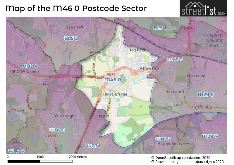
The M46 0 Postcode shares a border with WN7 5 (LEIGH), WN7 1 (LEIGH), WN7 2 (LEIGH), BL5 2 (Westhoughton), M29 8 (Tyldesley) and M46 9 (Atherton).
The sector is within the post town of MANCHESTER.
M46 0 is a postcode sector within the M46 postcode district which is within the M Manchester postcode area.
The Royal Mail delivery office for the M46 0 postal sector is the Atherton Delivery Office.
The area of the M46 0 postcode sector is 2.16 square miles which is 5.60 square kilometres or 1,384.04 square acres.
Waterways within the M46 0 postcode sector include the Lee Hall Brook, Small Brook.

Map of the M46 0 Postcode Sector
Explore the M46 0 postcode sector by using our free interactive map.
| M | 4 | 6 | - | 0 | X | X |
| M | 4 | 6 | Space | 0 | Letter | Letter |
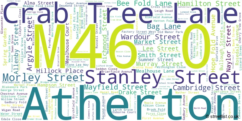
Official List of Streets
Atherton (170 Streets)
Unofficial Streets or Alternative Spellings
Atherton
BOLTON OLD ROAD BOLTON ROAD CANNON STREET CHURCH STREET DORSET ROAD ELIZABETH STREET HESKETH STREET KENT ROAD SOMERSET ROAD TYLDESLEY ROAD YORK STREET BATH STREET BELGRAVE STREET ECKERSLEY PRECINCT, MEALHOUSE LANE GIBFIELD PARK WAY HESKETH COURT HOLLAND STREET LANGLEY PLATT LANE LILFORD PARK WOODLAND TRAIL LIME STREET LONG CAUSEWAY MILLERS LANE PRAETON CLOSE RODNEY STREET SOUTH VIEW ST GEORGES PLACE TALBOT ROUNDABOUT TAVISTOCK STREET WOOD STREET YEWTREE AVENUELEIGH
ATHERLEIGH WAY ELMRIDGE ORCHARD LANE THE AVENUEWesthoughton
LOWER LEIGH ROADWeather Forecast for M46 0
Press Button to Show Forecast for Atherton
| Time Period | Icon | Description | Temperature | Rain Probability | Wind |
|---|---|---|---|---|---|
| 06:00 to 09:00 | Sunny day | 3.0°C (feels like 1.0°C) | 0.00% | SSW 2 mph | |
| 09:00 to 12:00 | Cloudy | 7.0°C (feels like 5.0°C) | 6.00% | SW 4 mph | |
| 12:00 to 15:00 | Cloudy | 10.0°C (feels like 7.0°C) | 19.00% | W 11 mph | |
| 15:00 to 18:00 | Heavy rain | 8.0°C (feels like 5.0°C) | 85.00% | W 13 mph | |
| 18:00 to 21:00 | Heavy rain | 9.0°C (feels like 6.0°C) | 90.00% | WSW 11 mph | |
| 21:00 to 00:00 | Heavy rain | 9.0°C (feels like 6.0°C) | 82.00% | W 13 mph |
Press Button to Show Forecast for Atherton
| Time Period | Icon | Description | Temperature | Rain Probability | Wind |
|---|---|---|---|---|---|
| 00:00 to 03:00 | Cloudy | 9.0°C (feels like 6.0°C) | 15.00% | WNW 16 mph | |
| 03:00 to 06:00 | Cloudy | 8.0°C (feels like 5.0°C) | 17.00% | WNW 16 mph | |
| 06:00 to 09:00 | Cloudy | 8.0°C (feels like 5.0°C) | 10.00% | NW 13 mph | |
| 09:00 to 12:00 | Cloudy | 9.0°C (feels like 6.0°C) | 6.00% | NW 18 mph | |
| 12:00 to 15:00 | Cloudy | 10.0°C (feels like 7.0°C) | 6.00% | NW 18 mph | |
| 15:00 to 18:00 | Cloudy | 11.0°C (feels like 8.0°C) | 6.00% | NW 16 mph | |
| 18:00 to 21:00 | Cloudy | 10.0°C (feels like 8.0°C) | 5.00% | NW 13 mph | |
| 21:00 to 00:00 | Partly cloudy (night) | 8.0°C (feels like 6.0°C) | 2.00% | NNW 9 mph |
Press Button to Show Forecast for Atherton
| Time Period | Icon | Description | Temperature | Rain Probability | Wind |
|---|---|---|---|---|---|
| 00:00 to 03:00 | Clear night | 6.0°C (feels like 4.0°C) | 2.00% | NNE 7 mph | |
| 03:00 to 06:00 | Clear night | 5.0°C (feels like 3.0°C) | 2.00% | NNE 4 mph | |
| 06:00 to 09:00 | Sunny day | 5.0°C (feels like 3.0°C) | 1.00% | NNE 4 mph | |
| 09:00 to 12:00 | Sunny day | 8.0°C (feels like 6.0°C) | 1.00% | NNE 4 mph | |
| 12:00 to 15:00 | Sunny day | 10.0°C (feels like 9.0°C) | 2.00% | NNW 4 mph | |
| 15:00 to 18:00 | Partly cloudy (day) | 11.0°C (feels like 10.0°C) | 2.00% | NNW 7 mph | |
| 18:00 to 21:00 | Partly cloudy (day) | 11.0°C (feels like 9.0°C) | 2.00% | NNW 7 mph | |
| 21:00 to 00:00 | Clear night | 8.0°C (feels like 7.0°C) | 1.00% | NNW 4 mph |
Press Button to Show Forecast for Atherton
| Time Period | Icon | Description | Temperature | Rain Probability | Wind |
|---|---|---|---|---|---|
| 00:00 to 03:00 | Partly cloudy (night) | 7.0°C (feels like 6.0°C) | 1.00% | N 4 mph | |
| 03:00 to 06:00 | Partly cloudy (night) | 6.0°C (feels like 5.0°C) | 1.00% | NNE 2 mph | |
| 06:00 to 09:00 | Cloudy | 7.0°C (feels like 6.0°C) | 5.00% | NE 2 mph | |
| 09:00 to 12:00 | Cloudy | 10.0°C (feels like 9.0°C) | 7.00% | N 4 mph | |
| 12:00 to 15:00 | Cloudy | 12.0°C (feels like 11.0°C) | 6.00% | NNE 7 mph | |
| 15:00 to 18:00 | Cloudy | 13.0°C (feels like 12.0°C) | 8.00% | NNE 7 mph | |
| 18:00 to 21:00 | Cloudy | 13.0°C (feels like 11.0°C) | 8.00% | NNE 7 mph | |
| 21:00 to 00:00 | Cloudy | 10.0°C (feels like 9.0°C) | 6.00% | N 7 mph |
Schools and Places of Education Within the M46 0 Postcode Sector
Atherton High School
Free schools
Hamilton Street, Atherton, Greater Manchester, M46 0AY
Head: Mr Ben Layzell
Ofsted Rating: Requires improvement
Inspection: 2021-10-20 (911 days ago)
Website: Visit Atherton High School Website
Phone: 01942885500
Number of Pupils: 509
Atherton St George's CofE Primary School
Academy converter
Derby Street, Manchester, , M46 0HJ
Head: Mrs Lisa Boardman
Ofsted Rating: Good
Inspection: 2023-06-21 (302 days ago)
Website: Visit Atherton St George's CofE Primary School Website
Phone: 01942883971
Number of Pupils: 361
Meadowbank Primary School & Children's Centre
Community school
Formby Avenue, Manchester, , M46 0HX
Head: Mrs Nichola Hill
Ofsted Rating: Good
Inspection: 2023-11-22 (148 days ago)
Website: Visit Meadowbank Primary School & Children's Centre Website
Phone: 01942874271
Number of Pupils: 223
Parklee Community School
Community school
Wardour Street, Wigan, Greater Manchester, M46 0AR
Head: Mrs Dawn Roper
Ofsted Rating: Good
Inspection: 2019-09-18 (1674 days ago)
Website: Visit Parklee Community School Website
Phone: 01942874203
Number of Pupils: 336
St Michael's CofE Primary School, Howe Bridge
Voluntary aided school
Leigh Road, Manchester, Lancashire, M46 0PA
Head: Mrs Fiona Quinlivan
Ofsted Rating: Good
Inspection: 2023-11-01 (169 days ago)
Website: Visit St Michael's CofE Primary School, Howe Bridge Website
Phone: 01942883118
Number of Pupils: 203
St Richard's Roman Catholic Primary School Atherton
Voluntary aided school
Flapper Fold Lane, Manchester, , M46 0HA
Head: Mrs DM Nulty
Ofsted Rating: Good
Inspection: 2022-01-20 (819 days ago)
Website: Visit St Richard's Roman Catholic Primary School Atherton Website
Phone: 01942882980
Number of Pupils: 158
House Prices in the M46 0 Postcode Sector
| Type of Property | 2018 Average | 2018 Sales | 2017 Average | 2017 Sales | 2016 Average | 2016 Sales | 2015 Average | 2015 Sales |
|---|---|---|---|---|---|---|---|---|
| Detached | £232,639 | 67 | £220,278 | 54 | £222,769 | 37 | £199,500 | 24 |
| Semi-Detached | £160,439 | 130 | £147,090 | 94 | £118,782 | 49 | £126,223 | 39 |
| Terraced | £109,247 | 127 | £103,090 | 102 | £101,802 | 97 | £94,757 | 96 |
| Flats | £84,377 | 28 | £70,089 | 18 | £73,950 | 20 | £76,388 | 12 |
Important Postcodes M46 0 in the Postcode Sector
M46 0AR is the postcode for MAIN BUILDING, Parklee Community School, Wardour Street
M46 0AY is the postcode for MAIN BUILDING, Hesketh Fletcher C of E High School, Hamilton Street
M46 0DF is the postcode for Jobcentre Plus, 129 Market Street
M46 0HA is the postcode for St. Richards RC School, Flapper Fold Lane, and St. Richards RC School, Flapper Fold Lane, Atherton
M46 0HJ is the postcode for Atherton St. Georges C of E Primary School, Derby Street, Atherton, and Atherton St. Georges C of E Primary School, Derby Street
M46 0HX is the postcode for Meadowbank Primary School & Nursery Education Centre, Formby Avenue, and MEADOWBANK PRIMARY SCHOOL, FORMBY AVENUE, ATHERTON
M46 0JS is the postcode for National Probation Service, 81 Gloucester Street, Atherton, and National Probation Service, 81 Gloucester Street
M46 0JT is the postcode for MAIN BUILDING, Greater Manchester Fire & Rescue Service, Fire Station, Gloucester Street
M46 0LE is the postcode for Atherton Health Centre, Nelson Street, and Atherton Health Centre, Nelson Street, Atherton
M46 0PA is the postcode for St. Michaels School, Leigh Road, Atherton, and St. Michaels School, Leigh Road
M46 0PJ is the postcode for Howe Bridge Sports Centre, Leigh Road, Atherton, and Howe Bridge Sports Centre, Leigh Road
| The M46 0 Sector is within these Local Authorities |
|
|---|---|
| The M46 0 Sector is within these Counties |
|
| The M46 0 Sector is within these Water Company Areas |
|