The M7 3 postcode sector is within the county of Greater Manchester.
Did you know? According to the 2021 Census, the M7 3 postcode sector is home to a bustling 5,985 residents!
Given that each sector allows for 400 unique postcode combinations. Letters C, I, K, M, O and V are not allowed in the last two letters of a postcode. With 144 postcodes already in use, this leaves 256 units available.
The M7 3 postal code covers the settlement of SALFORD.
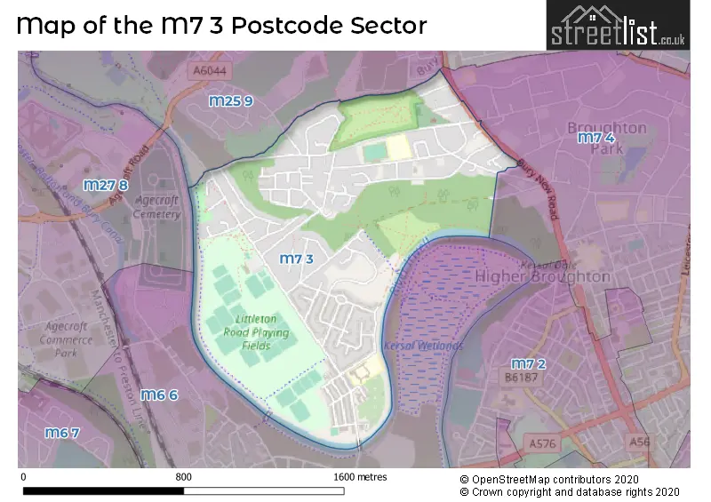
The M7 3 Postcode shares a border with M7 4 (SALFORD), M25 9 (Prestwich), M6 6 (SALFORD) and M27 8 (Swinton).
The sector is within the post town of SALFORD.
M7 3 is a postcode sector within the M7 postcode district which is within the M Manchester postcode area.
The Royal Mail delivery office for the M7 3 postal sector is the Manchester North Delivery Office.
The area of the M7 3 postcode sector is 0.69 square miles which is 1.80 square kilometres or 443.66 square acres.
Waterways within the M7 3 postcode sector include the River Irwell.

Map of the M7 3 Postcode Sector
Explore the M7 3 postcode sector by using our free interactive map.
| M | 7 | - | 3 | X | X |
| M | 7 | Space | 3 | Letter | Letter |
Official List of Streets
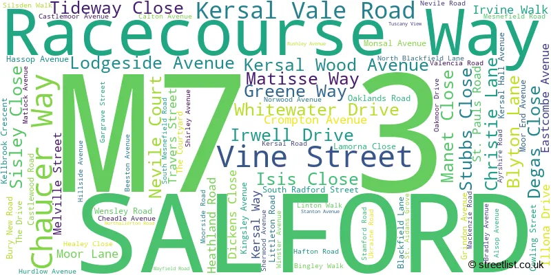
SALFORD (86 Streets)
Unofficial Streets or Alternative Spellings
Weather Forecast for M7 3
Press Button to Show Forecast for Lower Kersal
| Time Period | Icon | Description | Temperature | Rain Probability | Wind |
|---|---|---|---|---|---|
| 06:00 to 09:00 | Sunny day | 4.0°C (feels like 3.0°C) | 0.00% | N 2 mph | |
| 09:00 to 12:00 | Cloudy | 8.0°C (feels like 6.0°C) | 4.00% | WNW 4 mph | |
| 12:00 to 15:00 | Cloudy | 10.0°C (feels like 9.0°C) | 5.00% | NNW 4 mph | |
| 15:00 to 18:00 | Cloudy | 11.0°C (feels like 10.0°C) | 6.00% | NNW 7 mph | |
| 18:00 to 21:00 | Cloudy | 11.0°C (feels like 9.0°C) | 5.00% | NNW 7 mph | |
| 21:00 to 00:00 | Cloudy | 8.0°C (feels like 8.0°C) | 4.00% | NNE 4 mph |
Press Button to Show Forecast for Lower Kersal
| Time Period | Icon | Description | Temperature | Rain Probability | Wind |
|---|---|---|---|---|---|
| 00:00 to 03:00 | Cloudy | 7.0°C (feels like 6.0°C) | 4.00% | NNE 2 mph | |
| 03:00 to 06:00 | Cloudy | 7.0°C (feels like 6.0°C) | 13.00% | NE 2 mph | |
| 06:00 to 09:00 | Light rain | 6.0°C (feels like 5.0°C) | 44.00% | ENE 2 mph | |
| 09:00 to 12:00 | Light rain shower (day) | 8.0°C (feels like 7.0°C) | 33.00% | NE 4 mph | |
| 12:00 to 15:00 | Overcast | 10.0°C (feels like 8.0°C) | 11.00% | ENE 4 mph | |
| 15:00 to 18:00 | Cloudy | 11.0°C (feels like 10.0°C) | 10.00% | NE 4 mph | |
| 18:00 to 21:00 | Cloudy | 10.0°C (feels like 9.0°C) | 7.00% | NE 7 mph | |
| 21:00 to 00:00 | Cloudy | 8.0°C (feels like 7.0°C) | 7.00% | ENE 4 mph |
Press Button to Show Forecast for Lower Kersal
| Time Period | Icon | Description | Temperature | Rain Probability | Wind |
|---|---|---|---|---|---|
| 00:00 to 03:00 | Overcast | 7.0°C (feels like 6.0°C) | 11.00% | E 4 mph | |
| 03:00 to 06:00 | Overcast | 6.0°C (feels like 5.0°C) | 20.00% | SE 2 mph | |
| 06:00 to 09:00 | Overcast | 6.0°C (feels like 5.0°C) | 22.00% | SSE 2 mph | |
| 09:00 to 12:00 | Light rain | 7.0°C (feels like 6.0°C) | 52.00% | S 4 mph | |
| 12:00 to 15:00 | Overcast | 9.0°C (feels like 8.0°C) | 14.00% | S 4 mph | |
| 15:00 to 18:00 | Overcast | 10.0°C (feels like 9.0°C) | 14.00% | ENE 4 mph | |
| 18:00 to 21:00 | Cloudy | 10.0°C (feels like 9.0°C) | 13.00% | NNE 4 mph | |
| 21:00 to 00:00 | Cloudy | 9.0°C (feels like 8.0°C) | 11.00% | E 4 mph |
Press Button to Show Forecast for Lower Kersal
| Time Period | Icon | Description | Temperature | Rain Probability | Wind |
|---|---|---|---|---|---|
| 00:00 to 03:00 | Cloudy | 8.0°C (feels like 7.0°C) | 5.00% | E 2 mph | |
| 03:00 to 06:00 | Cloudy | 8.0°C (feels like 7.0°C) | 5.00% | E 4 mph | |
| 06:00 to 09:00 | Partly cloudy (day) | 7.0°C (feels like 6.0°C) | 3.00% | NE 4 mph | |
| 09:00 to 12:00 | Cloudy | 9.0°C (feels like 8.0°C) | 6.00% | NE 7 mph | |
| 12:00 to 15:00 | Cloudy | 12.0°C (feels like 10.0°C) | 6.00% | NE 9 mph | |
| 15:00 to 18:00 | Cloudy | 12.0°C (feels like 11.0°C) | 7.00% | NNE 9 mph | |
| 18:00 to 21:00 | Partly cloudy (day) | 12.0°C (feels like 10.0°C) | 5.00% | NE 9 mph | |
| 21:00 to 00:00 | Clear night | 9.0°C (feels like 7.0°C) | 3.00% | NE 7 mph |
Schools and Places of Education Within the M7 3 Postcode Sector
Lower Kersal Community Primary School
Community school
St Aidan's Grove, Salford, Greater Manchester, M7 3TN
Head: Miss Sarah Steward
Ofsted Rating: Good
Inspection: 2023-09-27 (206 days ago)
Website: Visit Lower Kersal Community Primary School Website
Phone: 01617922726
Number of Pupils: 230
Me'or High School
Other independent school
16 Moor Lane, , , M7 3WX
Head: Not Known
Ofsted Rating: Good
Inspection: 2022-07-14 (646 days ago)
Website: Visit Me'or High School Website
Phone: 03301228875
Number of Pupils: 43
St Paul's CofE Primary School
Voluntary controlled school
Nevile Road, Salford, Greater Manchester, M7 3PT
Head: Ms Jane Tyers
Ofsted Rating: Good
Inspection: 2022-06-22 (668 days ago)
Website: Visit St Paul's CofE Primary School Website
Phone: 01619212065
Number of Pupils: 210
House Prices in the M7 3 Postcode Sector
| Type of Property | 2018 Average | 2018 Sales | 2017 Average | 2017 Sales | 2016 Average | 2016 Sales | 2015 Average | 2015 Sales |
|---|---|---|---|---|---|---|---|---|
| Detached | £253,192 | 13 | £235,972 | 18 | £238,818 | 11 | £197,754 | 19 |
| Semi-Detached | £187,773 | 31 | £169,912 | 34 | £183,993 | 37 | £172,416 | 39 |
| Terraced | £143,670 | 47 | £111,468 | 31 | £115,845 | 25 | £118,069 | 32 |
| Flats | £99,878 | 27 | £92,087 | 39 | £77,539 | 38 | £79,467 | 39 |
Important Postcodes M7 3 in the Postcode Sector
M7 3NQ is the postcode for Salford Sports Village, 325 Littleton Road, and SALFORD SPORTS VILLAGE, 325 LITTLETON ROAD, SALFORD
M7 3PT is the postcode for St. Paul's CE Primary School, Nevile Road, and St. Pauls School, Nevile Road
M7 3SE is the postcode for WILLOW TREE HEALTHY LIVING, 94, Littleton Road
M7 3TN is the postcode for Lower Kersal Primary School, St. Aidans Grove
| The M7 3 Sector is within these Local Authorities |
|
|---|---|
| The M7 3 Sector is within these Counties |
|
| The M7 3 Sector is within these Water Company Areas |
|