The ME13 postcode district is a postal district located in the ME Medway postcode area with a population of 28,942 residents according to the 2021 England and Wales Census.
The area of the ME13 postcode district is 53.83 square miles which is 139.42 square kilometres or 34,450.97 acres.
Currently, the ME13 district has about 1009 postcode units spread across 4 geographic postcode sectors.
Given that each sector allows for 400 unique postcode combinations, the district has a capacity of 1,600 postcodes. With 1009 postcodes already in use, this leaves 591 units available.
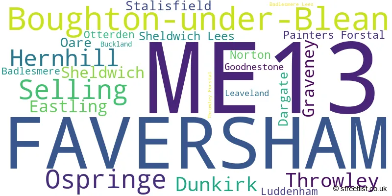
The largest settlement in the ME13 postal code is FAVERSHAM followed by Boughton-under-Blean, and Dunkirk.
The postcode area has a boundary with Thames Estuary.
The ME13 Postcode shares a border with ME9 (Iwade, Teynham, Newington), CT2 (CANTERBURY, Sturry, Blean), CT4 (Chartham, Bridge, Barham), TN25 (Wye, Sellindge, ASHFORD) and CT5 (WHITSTABLE, Chestfield, Seasalter).
In the ME13 postcode district, the primary settlement is Faversham, located in the county of Kent, England. Faversham is the most significant post town in this postcode district. Other significant settlements include Boughton-under-Blean, Hernhill, and Selling.
For the district ME13, we have data on 5 postcode sectors. Here's a breakdown: The sector ME13 0, covers Ospringe and Throwley and Eastling in Kent. The sector ME13 3 is non-geographic. It's often designated for PO Boxes, large organisations, or special services. The sector ME13 7, covers Faversham in Kent. The sector ME13 8, covers Faversham in Kent. The sector ME13 9, covers Boughton-Under-Blean and Selling and Hernhill and Dunkirk in Kent.

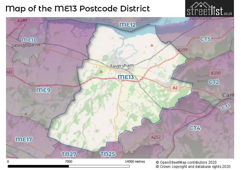
Map of the ME13 Postcode District
Explore the ME13 postcode district by using our free interactive map.
When it comes to local government, postal geography often disregards political borders. However, for a breakdown in the ME13 District: the district mostly encompasses the Swale District (B) (1043 postcodes), and finally, the Maidstone District (B) area (8 postcodes).
Recent House Sales in ME13
| Date | Price | Address |
|---|---|---|
| 19/10/2023 | £390,000 | Horselees Road, Boughton Under Blean, Faversham, ME13 9TG |
| 11/10/2023 | £220,000 | Nova Avenue, Faversham, ME13 8FW |
| 10/10/2023 | £450,000 | Berkeley Close, Dunkirk, Faversham, ME13 9TR |
| 09/10/2023 | £262,500 | Luton Road, Faversham, ME13 8HQ |
| 29/09/2023 | £190,000 | West Street, Faversham, ME13 7JB |
| 14/09/2023 | £90,000 | Sommerville Close, Faversham, ME13 8HP |
| 12/09/2023 | £347,500 | Preston Street, Faversham, ME13 8NU |
| 11/09/2023 | £320,000 | Church Road, Oare, Faversham, ME13 0QA |
| 04/09/2023 | £330,000 | Hazebrouck Road, Faversham, ME13 7PZ |
| 29/08/2023 | £319,000 | Falstaff Lane, Faversham, ME13 8UL |
Weather Forecast for ME13
Press Button to Show Forecast for Faversham
| Time Period | Icon | Description | Temperature | Rain Probability | Wind |
|---|---|---|---|---|---|
| 09:00 to 12:00 | Cloudy | 11.0°C (feels like 8.0°C) | 37.00% | NW 18 mph | |
| 12:00 to 15:00 | Light rain | 12.0°C (feels like 8.0°C) | 57.00% | NW 16 mph | |
| 15:00 to 18:00 | Overcast | 11.0°C (feels like 8.0°C) | 18.00% | N 13 mph | |
| 18:00 to 21:00 | Cloudy | 9.0°C (feels like 6.0°C) | 7.00% | N 13 mph | |
| 21:00 to 00:00 | Partly cloudy (night) | 6.0°C (feels like 3.0°C) | 4.00% | NNW 11 mph |
Press Button to Show Forecast for Faversham
| Time Period | Icon | Description | Temperature | Rain Probability | Wind |
|---|---|---|---|---|---|
| 00:00 to 03:00 | Partly cloudy (night) | 5.0°C (feels like 1.0°C) | 1.00% | NNW 11 mph | |
| 03:00 to 06:00 | Partly cloudy (night) | 4.0°C (feels like 0.0°C) | 4.00% | NNW 13 mph | |
| 06:00 to 09:00 | Cloudy | 5.0°C (feels like 1.0°C) | 5.00% | NNW 13 mph | |
| 09:00 to 12:00 | Overcast | 7.0°C (feels like 4.0°C) | 8.00% | N 16 mph | |
| 12:00 to 15:00 | Overcast | 9.0°C (feels like 6.0°C) | 8.00% | N 13 mph | |
| 15:00 to 18:00 | Cloudy | 9.0°C (feels like 6.0°C) | 6.00% | N 13 mph | |
| 18:00 to 21:00 | Overcast | 8.0°C (feels like 5.0°C) | 7.00% | N 11 mph | |
| 21:00 to 00:00 | Partly cloudy (night) | 6.0°C (feels like 3.0°C) | 1.00% | N 11 mph |
Press Button to Show Forecast for Faversham
| Time Period | Icon | Description | Temperature | Rain Probability | Wind |
|---|---|---|---|---|---|
| 00:00 to 03:00 | Cloudy | 5.0°C (feels like 3.0°C) | 6.00% | N 9 mph | |
| 03:00 to 06:00 | Overcast | 5.0°C (feels like 2.0°C) | 8.00% | NNW 9 mph | |
| 06:00 to 09:00 | Overcast | 6.0°C (feels like 3.0°C) | 10.00% | NNW 9 mph | |
| 09:00 to 12:00 | Overcast | 7.0°C (feels like 4.0°C) | 19.00% | N 13 mph | |
| 12:00 to 15:00 | Overcast | 9.0°C (feels like 6.0°C) | 9.00% | NNE 13 mph | |
| 15:00 to 18:00 | Partly cloudy (day) | 9.0°C (feels like 7.0°C) | 3.00% | NE 13 mph | |
| 18:00 to 21:00 | Sunny day | 8.0°C (feels like 5.0°C) | 1.00% | NE 13 mph | |
| 21:00 to 00:00 | Cloudy | 7.0°C (feels like 3.0°C) | 5.00% | NNE 11 mph |
Press Button to Show Forecast for Faversham
| Time Period | Icon | Description | Temperature | Rain Probability | Wind |
|---|---|---|---|---|---|
| 00:00 to 03:00 | Cloudy | 7.0°C (feels like 4.0°C) | 5.00% | NNE 11 mph | |
| 03:00 to 06:00 | Cloudy | 6.0°C (feels like 3.0°C) | 6.00% | NNE 11 mph | |
| 06:00 to 09:00 | Partly cloudy (day) | 7.0°C (feels like 4.0°C) | 2.00% | NNE 11 mph | |
| 09:00 to 12:00 | Cloudy | 8.0°C (feels like 5.0°C) | 7.00% | NNE 13 mph | |
| 12:00 to 15:00 | Cloudy | 9.0°C (feels like 6.0°C) | 10.00% | NE 13 mph | |
| 15:00 to 18:00 | Cloudy | 9.0°C (feels like 6.0°C) | 8.00% | NE 16 mph | |
| 18:00 to 21:00 | Partly cloudy (day) | 8.0°C (feels like 5.0°C) | 4.00% | NE 13 mph | |
| 21:00 to 00:00 | Cloudy | 7.0°C (feels like 4.0°C) | 7.00% | NNE 11 mph |
Where is the ME13 Postcode District?
The ME13 postcode district is located in Faversham, a district town in Kent, England. Faversham is situated near several towns: Whitstable is located to the North East, Sittingbourne is to the North West, Canterbury is to the East, Rochester is to the North, and Gillingham is to the West. Additionally, Faversham is approximately 46.34 miles away from the center of London.
The district is within the post town of FAVERSHAM.
The sector has postcodes within the nation of England.
The ME13 Postcode District is covers the following regions.
- Kent Thames Gateway - Kent - South East (England)
- Mid Kent - Kent - South East (England)
| Postcode Sector | Delivery Office |
|---|---|
| ME13 0 | Faversham Delivery Office |
| ME13 7 | Faversham Delivery Office |
| ME13 8 | Faversham Delivery Office |
| ME13 9 | Faversham Delivery Office |
| M | E | 1 | 3 | - | X | X | X |
| M | E | 1 | 3 | Space | Numeric | Letter | Letter |
Tourist Attractions within the Postcode Area
We found 4 visitor attractions within the ME13 postcode area
| The Oare Gunpowder Works Country Park |
|---|
| Country Parks |
| Country Park |
| View The Oare Gunpowder Works Country Park on Google Maps |
| Oare Marshes |
| Wildlife |
| Nature Reserve / Wetlands / Wildlife Trips |
| View Oare Marshes on Google Maps |
| South Swale Nature Reserve |
| Wildlife |
| Nature Reserve / Wetlands / Wildlife Trips |
| View South Swale Nature Reserve on Google Maps |
| Shepherd Neame Brewery Tours |
| Workplace |
| Distillery / Vineyard or Brewery |
| View Shepherd Neame Brewery Tours on Google Maps |
Current Monthly Rental Prices
| # Bedrooms | Min Price | Max Price | Avg Price |
|---|---|---|---|
| £775 | £775 | £775 | |
| 1 | £725 | £900 | £825 |
| 2 | £1,000 | £1,500 | £1,250 |
| 3 | £1,375 | £2,200 | £1,631 |
| 4 | £1,450 | £2,400 | £1,720 |
Current House Prices
| # Bedrooms | Min Price | Max Price | Avg Price |
|---|---|---|---|
| £40,000 | £5,000,000 | £736,667 | |
| 1 | £75,000 | £220,000 | £167,615 |
| 2 | £77,875 | £475,000 | £300,859 |
| 3 | £140,000 | £695,000 | £395,062 |
| 4 | £188,000 | £1,350,000 | £609,127 |
| 5 | £479,000 | £2,000,000 | £929,100 |
| 6 | £750,000 | £3,000,000 | £1,434,286 |
| 7 | £895,000 | £895,000 | £895,000 |
Estate Agents who Operate in the ME13 District
| Logo | Name | Brand Name | Address | Contact Number | Total Properties |
|---|---|---|---|---|---|
 | Faversham | Iliffe & Iliffe | 16a Market Place, Faversham, ME13 7AE | 01795 905397 | 52 |
 | Faversham | Wards | 8 Market Place, Faversham, Kent, ME13 7AG | 01795 905077 | 42 |
 | Faversham | Foundation Estate Agents | Suite 1 3 Jubilee Way Faversham ME13 8GD | 01227 204639 | 29 |
 | Faversham | Miles & Barr | 4 Limes Place, Preston Street, Faversham, ME13 8PQ | 01795 905391 | 23 |
 | Kent | SAXON SHORE LIMITED | Saxon Shore The Alexander Centre Faversham, Kent Me13 8NZ | 01795 718589 | 15 |
- Boughton under Blean
- Broom Street
- Challock
- Chilham
- Culmers
- Dargate
- Deerton Street
- Dunkirk
- Eastling
- Faversham
- Faversham Lakes
- Fostall
- Four Oaks
- Goodnestone
- Graveney
- Gushmere
- Hernhill
- Highstreet
- Hockley
- Hogben's Hill
- Lewson Street
- Neames Forstal
- North Street
- Norton Ash
- Oare
- Oversland
- Paddock
- Painter's Forstal
- Perrywood
- Selling
- Sheldwich
- Sheldwich Lees
- Shottenden
- South Street
- Stalisfield Green
- Staplestreet
- Stocker's Head
- The Valley
- Throwley Forstal
- Tickham
- Uplees
- Upper Harbledown
- Warren Street
- Waterham
- Whitehill
- Winterbourne
- Yewhedges
- Yorkletts
| Type of Property | 2018 Average | 2018 Sales | 2017 Average | 2017 Sales | 2016 Average | 2016 Sales | 2015 Average | 2015 Sales |
|---|---|---|---|---|---|---|---|---|
| Detached | £532,197 | 75 | £479,378 | 67 | £470,113 | 52 | £406,006 | 74 |
| Semi-Detached | £326,898 | 99 | £301,197 | 117 | £298,289 | 124 | £264,405 | 107 |
| Terraced | £286,596 | 186 | £266,469 | 196 | £259,544 | 181 | £233,638 | 246 |
| Flats | £185,983 | 49 | £181,784 | 59 | £173,253 | 61 | £171,043 | 77 |
Hotels within the Postcode Area
We found 11 hotels and guest houses within the ME13 postcode area