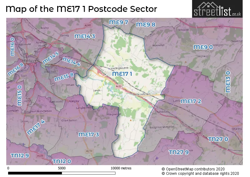
The ME17 1 postcode sector is within the county of Kent.
Did you know? According to the 2021 Census, the ME17 1 postcode sector is home to a bustling 6,700 residents!
Given that each sector allows for 400 unique postcode combinations. Letters C, I, K, M, O and V are not allowed in the last two letters of a postcode. With 299 postcodes already in use, this leaves 101 units available.
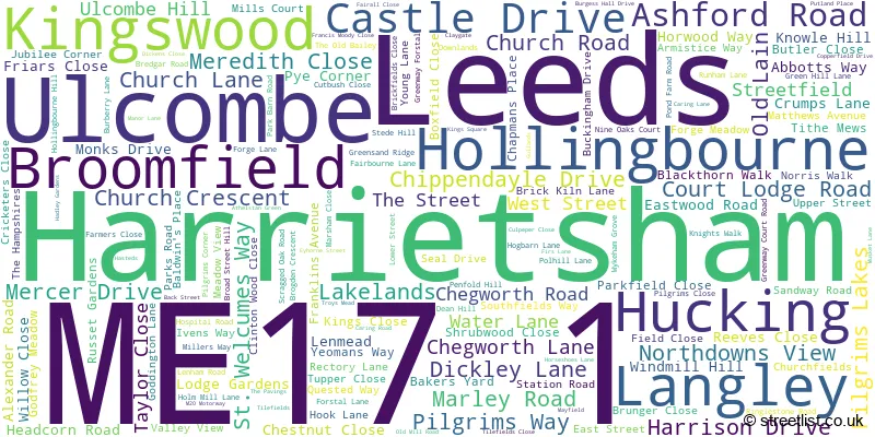
The largest settlement in the ME17 1 postal code is Harrietsham followed by Hollingbourne, and Leeds.
The ME17 1 Postcode shares a border with ME9 0 (Doddington, Rodmersham, Lynsted), ME9 7 (Newington, Upchurch, Lower Halstow), ME9 8 (Iwade, Borden, Bobbing), ME14 3 (Detling, Sandling, Boxley), ME15 8 (MAIDSTONE, Bearsted, Downswood), ME17 2 (Lenham, Lenham Heath, Grafty Green), ME17 3 (Sutton Valence, MAIDSTONE, Langley), TN27 9 (Headcorn, Egerton) and ME14 4 (Bearsted, Thurnham, Weavering).
The sector is within the post town of MAIDSTONE.
ME17 1 is a postcode sector within the ME17 postcode district which is within the ME Medway postcode area.
The Royal Mail delivery office for the ME17 1 postal sector is the Maidstone Delivery Office.
The area of the ME17 1 postcode sector is 21.85 square miles which is 56.58 square kilometres or 13,980.88 square acres.
The ME17 1 postcode sector is crossed by the M20 motorway.
Waterways within the ME17 1 postcode sector include the Len.

Map of the ME17 1 Postcode Sector
Explore the ME17 1 postcode sector by using our free interactive map.
| M | E | 1 | 7 | - | 1 | X | X |
| M | E | 1 | 7 | Space | 1 | Letter | Letter |
Official List of Streets
Harrietsham (78 Streets)
Broomfield (4 Streets)
Hollingbourne (26 Streets)
Leeds (16 Streets)
Ulcombe (15 Streets)
Hucking (5 Streets)
Langley (4 Streets)
Unofficial Streets or Alternative Spellings
Harrietsham
ABBOTTS WAY CASTLE DRIVE FRIARS CLOSE KINGS CLOSE KNIGHTS WALK MILLERS WAY MONKS DRIVE PILGRIMS CLOSE REEVES CLOSE AVENUE OF REMEMBRANCE BOURNESIDE TERRACE BUNHAM LANE BURCHELLS WOOD ROAD CHURCH GREEN COLDBLOW LANE DEANS HILL FARMER CLOSE FRANKLIN WAY GEORGE LANE GREENWAY LANE HAZEL STREET ROAD HOLLINGBOURNE INTERCHANGE KH 140 KH 253 KH 266 KH173 KH175 KH192 KH193 KH194 KH198 KH204 KH205 KH207 KH207A KH244 KH245 KH246 KH247 KH249 KH250 KH256 KH312/3 KH314 KH316 KH351 KH356 KH357 KH363 KH642 MILNERS NEW COTTAGES OLD MILL LANE ORCHARD ROW POLEHILL LANE STATION APPROACH THE WHEELWRIGHTS TILDEN ROAD TILE FIELDS TILE FIELDS CLOSE YEOMANS WAYThurnham
COLDHARBOUR LANEGrafty Green
EASTWOOD ROAD ELMSTONE HOLE ROADKingswood
BROOMFIELD ROAD GRAVELLY BOTTOM ROADEast Sutton
BRICK KILN LANESutton Valence
STICKFAST LANELangley
LEEDS ROADOtham
AVERY LANEBearsted
ASHFORD ROAD CARING LANEStockbury
RUMSTEAD LANEBoxley
PILGRIMS WAYWeather Forecast for ME17 1
Press Button to Show Forecast for Leeds Castle Gardens
| Time Period | Icon | Description | Temperature | Rain Probability | Wind |
|---|---|---|---|---|---|
| 21:00 to 00:00 | Cloudy | 6.0°C (feels like 5.0°C) | 49.00% | NE 4 mph |
Press Button to Show Forecast for Leeds Castle Gardens
| Time Period | Icon | Description | Temperature | Rain Probability | Wind |
|---|---|---|---|---|---|
| 00:00 to 03:00 | Overcast | 6.0°C (feels like 4.0°C) | 12.00% | ENE 4 mph | |
| 03:00 to 06:00 | Cloudy | 5.0°C (feels like 3.0°C) | 5.00% | NE 4 mph | |
| 06:00 to 09:00 | Cloudy | 5.0°C (feels like 2.0°C) | 6.00% | NE 7 mph | |
| 09:00 to 12:00 | Cloudy | 7.0°C (feels like 4.0°C) | 6.00% | NE 9 mph | |
| 12:00 to 15:00 | Cloudy | 9.0°C (feels like 6.0°C) | 13.00% | ENE 9 mph | |
| 15:00 to 18:00 | Cloudy | 9.0°C (feels like 7.0°C) | 12.00% | ENE 9 mph | |
| 18:00 to 21:00 | Cloudy | 8.0°C (feels like 6.0°C) | 11.00% | ENE 7 mph | |
| 21:00 to 00:00 | Cloudy | 5.0°C (feels like 3.0°C) | 12.00% | ENE 7 mph |
Press Button to Show Forecast for Leeds Castle Gardens
| Time Period | Icon | Description | Temperature | Rain Probability | Wind |
|---|---|---|---|---|---|
| 00:00 to 03:00 | Cloudy | 5.0°C (feels like 3.0°C) | 18.00% | ENE 7 mph | |
| 03:00 to 06:00 | Cloudy | 6.0°C (feels like 3.0°C) | 18.00% | ENE 7 mph | |
| 06:00 to 09:00 | Overcast | 7.0°C (feels like 5.0°C) | 20.00% | ENE 7 mph | |
| 09:00 to 12:00 | Cloudy | 10.0°C (feels like 8.0°C) | 16.00% | E 9 mph | |
| 12:00 to 15:00 | Light rain | 11.0°C (feels like 9.0°C) | 47.00% | E 11 mph | |
| 15:00 to 18:00 | Light rain | 11.0°C (feels like 9.0°C) | 48.00% | ENE 11 mph | |
| 18:00 to 21:00 | Light rain | 10.0°C (feels like 7.0°C) | 52.00% | ENE 11 mph | |
| 21:00 to 00:00 | Heavy rain | 9.0°C (feels like 7.0°C) | 73.00% | ENE 11 mph |
Press Button to Show Forecast for Leeds Castle Gardens
| Time Period | Icon | Description | Temperature | Rain Probability | Wind |
|---|---|---|---|---|---|
| 00:00 to 03:00 | Light rain | 10.0°C (feels like 8.0°C) | 56.00% | ESE 9 mph | |
| 03:00 to 06:00 | Light rain shower (night) | 9.0°C (feels like 7.0°C) | 39.00% | SSE 11 mph | |
| 06:00 to 09:00 | Cloudy | 9.0°C (feels like 7.0°C) | 19.00% | SSE 11 mph | |
| 09:00 to 12:00 | Light rain shower (day) | 11.0°C (feels like 8.0°C) | 39.00% | S 16 mph | |
| 12:00 to 15:00 | Light rain shower (day) | 12.0°C (feels like 9.0°C) | 42.00% | S 16 mph | |
| 15:00 to 18:00 | Light rain shower (day) | 13.0°C (feels like 10.0°C) | 36.00% | SSW 16 mph | |
| 18:00 to 21:00 | Light rain shower (day) | 12.0°C (feels like 10.0°C) | 32.00% | SSW 9 mph | |
| 21:00 to 00:00 | Partly cloudy (night) | 9.0°C (feels like 7.0°C) | 8.00% | SW 9 mph |
Schools and Places of Education Within the ME17 1 Postcode Sector
Harrietsham Church of England Primary School
Voluntary controlled school
West Street, Maidstone, Kent, ME17 1JZ
Head: Mrs Tara Deevoy
Ofsted Rating: Good
Inspection: 2018-06-12 (2144 days ago)
Website: Visit Harrietsham Church of England Primary School Website
Phone: 01622859261
Number of Pupils: 309
Hollingbourne Primary School
Community school
Eyhorne Street, Maidstone, Kent, ME17 1UA
Head: Mrs Helen Bradley-Wyatt
Ofsted Rating: Good
Inspection: 2022-03-01 (786 days ago)
Website: Visit Hollingbourne Primary School Website
Phone: 01622880270
Number of Pupils: 96
Leeds and Broomfield Church of England Primary School
Voluntary controlled school
Lower Street, Maidstone, Kent, ME17 1RL
Head: Mrs Fiona Steer
Ofsted Rating: Good
Inspection: 2021-10-19 (919 days ago)
Website: Visit Leeds and Broomfield Church of England Primary School Website
Phone: 01622861398
Number of Pupils: 84
Ulcombe Church of England Primary School
Voluntary controlled school
The Street, Maidstone, Kent, ME17 1DU
Head: Ms Emma Masters
Ofsted Rating: Good
Inspection: 2019-11-27 (1611 days ago)
Website: Visit Ulcombe Church of England Primary School Website
Phone: 01622842903
Number of Pupils: 63
House Prices in the ME17 1 Postcode Sector
| Type of Property | 2018 Average | 2018 Sales | 2017 Average | 2017 Sales | 2016 Average | 2016 Sales | 2015 Average | 2015 Sales |
|---|---|---|---|---|---|---|---|---|
| Detached | £535,251 | 65 | £519,041 | 61 | £578,625 | 44 | £485,111 | 45 |
| Semi-Detached | £342,603 | 46 | £362,255 | 61 | £296,375 | 26 | £291,214 | 21 |
| Terraced | £270,822 | 17 | £299,844 | 26 | £263,929 | 27 | £249,978 | 15 |
| Flats | £293,998 | 2 | £363,998 | 3 | £331,750 | 4 | £283,750 | 4 |
Important Postcodes ME17 1 in the Postcode Sector
ME17 1AJ is the postcode for School House, Ashford Road
ME17 1DU is the postcode for Ulcombe C of E Primary School, The Street
ME17 1JZ is the postcode for Harrietsham Church of England Primary School, West Street, and HARRIETSHAM CHURCH OF ENGLAND PRIMARY SCHOOL, WEST STREET, HARRIETSHAM
ME17 1RL is the postcode for Leeds & Broomfield C of E School, Lower Street
ME17 1UA is the postcode for Hollingbourne Cp School, Eyhorne Street
| The ME17 1 Sector is within these Local Authorities |
|
|---|---|
| The ME17 1 Sector is within these Counties |
|
| The ME17 1 Sector is within these Water Company Areas |
|
Tourist Attractions within the ME17 1 Postcode Area
We found 1 visitor attractions within the ME17 postcode area
| Go Ape! Tree Top Adventure - Leeds Castle |
|---|
| Country Parks |
| Country Park |
| View Go Ape! Tree Top Adventure - Leeds Castle on Google Maps |