The ME20 postcode district is a postal district located in the ME Medway postcode area with a population of 21,776 residents according to the 2021 England and Wales Census.
The area of the ME20 postcode district is 7.75 square miles which is 20.08 square kilometres or 4,962.68 acres.
Currently, the ME20 district has about 532 postcode units spread across 2 geographic postcode sectors.
Given that each sector allows for 400 unique postcode combinations, the district has a capacity of 800 postcodes. With 532 postcodes already in use, this leaves 268 units available.
The largest settlement in the ME20 postal code is Larkfield followed by AYLESFORD, and Ditton.
The ME20 Postcode shares a border with ME5 (CHATHAM, Walderslade, Blue Bell Hill), ME14 (MAIDSTONE, Bearsted, Weavering), ME16 (MAIDSTONE, Allington, Barming), ME19 (Kings Hill, East Malling, WEST MALLING), ME6 (SNODLAND) and ME1 (ROCHESTER, Wouldham, Burham).
The primary settlement in the ME20 postcode district is Aylesford, located in the county of Kent in England. There are also other significant settlements in this district, including Ditton, Larkfield, Blue Bell Hill, Eccles, Quarry Wood, and Royal British Legion Village.
For the district ME20, we have data on 2 postcode sectors. Here's a breakdown: The sector ME20 6, covers Larkfield and Ditton in Kent. The sector ME20 7, covers Aylesford and Eccles in Kent.

Map of the ME20 Postcode District
Explore the ME20 postcode district by using our free interactive map.
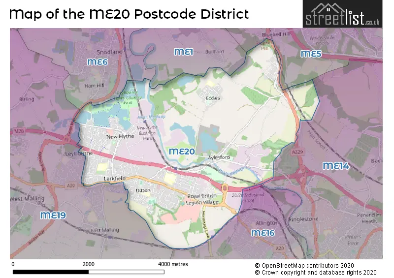
When it comes to local government, postal geography often disregards political borders. However, for a breakdown in the ME20 District: the district mostly encompasses the Tonbridge and Malling District (B) (529 postcodes), and finally, the Maidstone District (B) area (14 postcodes).
Recent House Sales in ME20
| Date | Price | Address |
|---|---|---|
| 06/10/2023 | £540,000 | Willow Road, Larkfield, Aylesford, ME20 6QZ |
| 08/09/2023 | £438,000 | Fernleigh Rise, Ditton, Aylesford, ME20 6BS |
| 04/09/2023 | £285,000 | Keats Road, Larkfield, Aylesford, ME20 6TR |
| 01/09/2023 | £535,000 | Fielding Drive, Larkfield, Aylesford, ME20 6TY |
| 01/09/2023 | £275,000 | Culpeper Road, Aylesford, ME20 7FJ |
| 01/09/2023 | £318,000 | Brampton Field, Ditton, Aylesford, ME20 6ED |
| 31/08/2023 | £475,000 | Lunsford Lane, Larkfield, Aylesford, ME20 6HW |
| 30/08/2023 | £485,000 | Priory Grove, Ditton, Aylesford, ME20 6BB |
| 30/08/2023 | £525,000 | The Stream, Ditton, Aylesford, ME20 6AG |
| 29/08/2023 | £735,000 | Holt Wood Avenue, Aylesford, ME20 7QH |
Weather Forecast for ME20
Press Button to Show Forecast for East Malling
| Time Period | Icon | Description | Temperature | Rain Probability | Wind |
|---|---|---|---|---|---|
| 15:00 to 18:00 | Overcast | 10.0°C (feels like 8.0°C) | 12.00% | N 9 mph | |
| 18:00 to 21:00 | Cloudy | 9.0°C (feels like 7.0°C) | 8.00% | N 9 mph | |
| 21:00 to 00:00 | Cloudy | 7.0°C (feels like 4.0°C) | 7.00% | N 7 mph |
Press Button to Show Forecast for East Malling
| Time Period | Icon | Description | Temperature | Rain Probability | Wind |
|---|---|---|---|---|---|
| 00:00 to 03:00 | Partly cloudy (night) | 5.0°C (feels like 2.0°C) | 0.00% | NW 7 mph | |
| 03:00 to 06:00 | Clear night | 3.0°C (feels like 0.0°C) | 0.00% | NW 7 mph | |
| 06:00 to 09:00 | Partly cloudy (day) | 3.0°C (feels like 0.0°C) | 1.00% | NNW 7 mph | |
| 09:00 to 12:00 | Cloudy | 7.0°C (feels like 4.0°C) | 4.00% | NNW 11 mph | |
| 12:00 to 15:00 | Cloudy | 10.0°C (feels like 7.0°C) | 4.00% | NNW 11 mph | |
| 15:00 to 18:00 | Cloudy | 11.0°C (feels like 8.0°C) | 4.00% | NNW 11 mph | |
| 18:00 to 21:00 | Cloudy | 9.0°C (feels like 7.0°C) | 4.00% | N 9 mph | |
| 21:00 to 00:00 | Clear night | 6.0°C (feels like 4.0°C) | 0.00% | NE 4 mph |
Press Button to Show Forecast for East Malling
| Time Period | Icon | Description | Temperature | Rain Probability | Wind |
|---|---|---|---|---|---|
| 00:00 to 03:00 | Cloudy | 5.0°C (feels like 3.0°C) | 3.00% | WSW 4 mph | |
| 03:00 to 06:00 | Cloudy | 3.0°C (feels like 2.0°C) | 4.00% | SW 2 mph | |
| 06:00 to 09:00 | Cloudy | 5.0°C (feels like 3.0°C) | 4.00% | WSW 4 mph | |
| 09:00 to 12:00 | Cloudy | 9.0°C (feels like 7.0°C) | 6.00% | W 9 mph | |
| 12:00 to 15:00 | Cloudy | 12.0°C (feels like 10.0°C) | 12.00% | W 9 mph | |
| 15:00 to 18:00 | Cloudy | 12.0°C (feels like 10.0°C) | 9.00% | WNW 9 mph | |
| 18:00 to 21:00 | Cloudy | 11.0°C (feels like 10.0°C) | 9.00% | WNW 7 mph | |
| 21:00 to 00:00 | Cloudy | 8.0°C (feels like 7.0°C) | 8.00% | ENE 2 mph |
Press Button to Show Forecast for East Malling
| Time Period | Icon | Description | Temperature | Rain Probability | Wind |
|---|---|---|---|---|---|
| 00:00 to 03:00 | Cloudy | 6.0°C (feels like 5.0°C) | 6.00% | NE 4 mph | |
| 03:00 to 06:00 | Cloudy | 5.0°C (feels like 4.0°C) | 6.00% | NE 2 mph | |
| 06:00 to 09:00 | Cloudy | 6.0°C (feels like 4.0°C) | 15.00% | ENE 2 mph | |
| 09:00 to 12:00 | Cloudy | 9.0°C (feels like 7.0°C) | 9.00% | ENE 7 mph | |
| 12:00 to 15:00 | Cloudy | 11.0°C (feels like 9.0°C) | 13.00% | SE 9 mph | |
| 15:00 to 18:00 | Cloudy | 11.0°C (feels like 9.0°C) | 12.00% | SE 9 mph | |
| 18:00 to 21:00 | Cloudy | 10.0°C (feels like 8.0°C) | 11.00% | SE 9 mph | |
| 21:00 to 00:00 | Cloudy | 8.0°C (feels like 6.0°C) | 12.00% | ESE 4 mph |
Press Button to Show Forecast for East Malling
| Time Period | Icon | Description | Temperature | Rain Probability | Wind |
|---|---|---|---|---|---|
| 00:00 to 03:00 | Cloudy | 7.0°C (feels like 6.0°C) | 14.00% | ESE 4 mph | |
| 03:00 to 06:00 | Cloudy | 7.0°C (feels like 5.0°C) | 12.00% | ESE 4 mph | |
| 06:00 to 09:00 | Cloudy | 8.0°C (feels like 6.0°C) | 13.00% | ESE 4 mph | |
| 09:00 to 12:00 | Cloudy | 11.0°C (feels like 9.0°C) | 12.00% | SE 9 mph | |
| 12:00 to 15:00 | Light rain shower (day) | 13.0°C (feels like 11.0°C) | 32.00% | SE 11 mph | |
| 15:00 to 18:00 | Cloudy | 14.0°C (feels like 12.0°C) | 16.00% | SE 11 mph | |
| 18:00 to 21:00 | Cloudy | 12.0°C (feels like 11.0°C) | 13.00% | SE 9 mph | |
| 21:00 to 00:00 | Cloudy | 10.0°C (feels like 9.0°C) | 12.00% | SE 7 mph |
Where is the ME20 Postcode District?
The ME20 postcode district is located in Aylesford, which is a town in the United Kingdom. Aylesford is nearby several other towns, including Snodland to the North West, West Malling to the South West, Maidstone to the South East, Chatham to the North East, and Rochester to the North. Additionally, the distance from Aylesford to the center of London is approximately 29.4 miles.
The district is within the post town of AYLESFORD.
The sector has postcodes within the nation of England.
The ME20 Postcode District is covers the following regions.
- West Kent - Kent - South East (England)
- Mid Kent - Kent - South East (England)
| Postcode Sector | Delivery Office |
|---|---|
| ME20 6 | Medway Valley Delivery Office |
| ME20 7 | Medway Valley Delivery Office |
| M | E | 2 | 0 | - | X | X | X |
| M | E | 2 | 0 | Space | Numeric | Letter | Letter |
Tourist Attractions within the Postcode Area
We found 1 visitor attractions within the ME20 postcode area
| Ditton Heritage Centre Ltd |
|---|
| Visitor Centres |
| Heritage / Visitor Centre |
| View Ditton Heritage Centre Ltd on Google Maps |
Current Monthly Rental Prices
| # Bedrooms | Min Price | Max Price | Avg Price |
|---|---|---|---|
| £445 | £445 | £445 | |
| 1 | £995 | £995 | £995 |
| 2 | £1,300 | £1,650 | £1,500 |
| 3 | £1,650 | £1,800 | £1,725 |
| 4 | £1,800 | £1,900 | £1,833 |
Current House Prices
| # Bedrooms | Min Price | Max Price | Avg Price |
|---|---|---|---|
| £375,000 | £375,000 | £375,000 | |
| 1 | £165,000 | £230,000 | £197,500 |
| 2 | £117,500 | £725,000 | £286,269 |
| 3 | £210,000 | £1,000,000 | £412,389 |
| 4 | £314,000 | £1,000,000 | £550,912 |
| 5 | £313,500 | £1,000,000 | £578,955 |
| 6 | £725,000 | £725,000 | £725,000 |
| 7 | £1,500,000 | £1,500,000 | £1,500,000 |
Estate Agents who Operate in the ME20 District
| Logo | Name | Brand Name | Address | Contact Number | Total Properties |
|---|---|---|---|---|---|
 | Larkfield | Wards | 746 London Road, Larkfield, Maidstone, Kent, ME20 6BG | 01732 496441 | 27 |
 | Malling | Simon Miller & Company | The Inn House, 777 London Road, Larkfield, ME20 6DE | 01732 444827 | 13 |
 | Worthing | Homewise | 1 Liverpool Gardens Worthing BN11 1TF | 01903 497338 | 12 |
 | Aylesford | Bluebell Estates | 27 High Street, Aylesford, Kent, ME20 7AX | 01622 717500 | 12 |
 | Larkfield | Page & Wells | 712 London Road, Larkfield, ME20 6BL | 01732 443051 | 9 |
| Type of Property | 2018 Average | 2018 Sales | 2017 Average | 2017 Sales | 2016 Average | 2016 Sales | 2015 Average | 2015 Sales |
|---|---|---|---|---|---|---|---|---|
| Detached | £477,018 | 55 | £462,212 | 73 | £466,181 | 96 | £504,129 | 65 |
| Semi-Detached | £327,969 | 139 | £323,662 | 134 | £300,824 | 136 | £270,324 | 153 |
| Terraced | £278,344 | 98 | £275,408 | 152 | £257,924 | 123 | £233,443 | 148 |
| Flats | £207,025 | 39 | £198,640 | 59 | £235,277 | 71 | £211,384 | 54 |