The ME9 7 postcode sector is within the county of Kent.
Did you know? According to the 2021 Census, the ME9 7 postcode sector is home to a bustling 7,866 residents!
Given that each sector allows for 400 unique postcode combinations. Letters C, I, K, M, O and V are not allowed in the last two letters of a postcode. With 263 postcodes already in use, this leaves 137 units available.
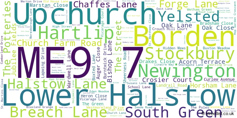
The largest settlement in the ME9 7 postal code is Newington followed by Upchurch, and Lower Halstow.
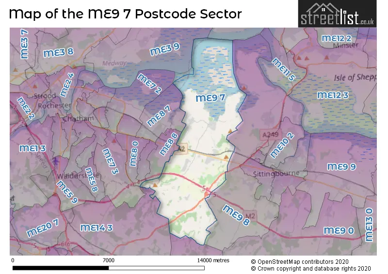
The ME9 7 Postcode shares a border with ME7 3 (Hempstead, GILLINGHAM, Bredhurst), ME8 7 (Rainham), ME8 8 (Rainham), ME8 9 (GILLINGHAM, Rainham), ME9 8 (Iwade, Borden, Bobbing), ME14 3 (Detling, Sandling, Boxley), ME17 1 (Harrietsham, Hollingbourne, Leeds) and ME8 0 (GILLINGHAM, Gillingham Business Park).
The sector is within the post town of SITTINGBOURNE.
ME9 7 is a postcode sector within the ME9 postcode district which is within the ME Medway postcode area.
The Royal Mail delivery office for the ME9 7 postal sector is the Sittingbourne Delivery Office.
The area of the ME9 7 postcode sector is 16.47 square miles which is 42.66 square kilometres or 10,542.30 square acres.
The ME9 7 postcode sector is crossed by the M2 motorway.
The ME9 7 postcode sector is crossed by the A249 Major A road.

Map of the ME9 7 Postcode Sector
Explore the ME9 7 postcode sector by using our free interactive map.
| M | E | 9 | - | 7 | X | X |
| M | E | 9 | Space | 7 | Letter | Letter |
Official List of Streets
Newington (41 Streets)
Hartlip (18 Streets)
Lower Halstow (17 Streets)
Stockbury (18 Streets)
Upchurch (26 Streets)
Borden (5 Streets)
South Green (2 Streets)
Yelsted (1 Streets)
Unofficial Streets or Alternative Spellings
Iwade
BASSER HILL RASPBERRY HILL LANENewington
DENNIS WILLCOCKS CLOSE ST. MARKS CLOSE ST. MARTINS CLOSE ST. MATTHEWS CLOSE ST. STEPHENS CLOSEBobbing
KEYCOL HILL AMELS HILL CALLOWS DRIVE CHERRY HILL COURT CHURCH HILL COWSTEAD LANE COX STREET CRADLES ROAD FRANKAPPS CLOSE GREEN LANE HAYES LANE HAZEL STREET ROAD HOLLOW LANE HONEYCROCK HILL HORSHAM HILL KENNEL BARN ROAD LINEACRE WAY MAGPIE LANE MATTS HILL LANE OAD STREET LINK ROAD PETT LANE RUMSTEAD ROAD SOUTH GREEN LANE SOUTHLEES LANE STABLE MEWS STEPS HILL ROAD STOCKBURY FLYOVER STOCKBURY ROUNDABOUT WORMDALE HILL OVERBRIDGE WORMDALE ROAD YELSTED LANEUpchurch
ACORN TERRACERainham
CANTERBURY LANE HORSHAM LANE LONDON ROAD SOUTH BUSH LANE WALLBRIDGE LANEDetling
BIMBURY LANE COX STREETWeather Forecast for ME9 7
Press Button to Show Forecast for Sittingbourne
| Time Period | Icon | Description | Temperature | Rain Probability | Wind |
|---|---|---|---|---|---|
| 18:00 to 21:00 | Light rain | 8.0°C (feels like 7.0°C) | 56.00% | N 7 mph | |
| 21:00 to 00:00 | Cloudy | 7.0°C (feels like 6.0°C) | 12.00% | NE 4 mph |
Press Button to Show Forecast for Sittingbourne
| Time Period | Icon | Description | Temperature | Rain Probability | Wind |
|---|---|---|---|---|---|
| 00:00 to 03:00 | Overcast | 6.0°C (feels like 5.0°C) | 12.00% | NE 7 mph | |
| 03:00 to 06:00 | Cloudy | 6.0°C (feels like 3.0°C) | 5.00% | NE 7 mph | |
| 06:00 to 09:00 | Cloudy | 6.0°C (feels like 3.0°C) | 5.00% | NNE 9 mph | |
| 09:00 to 12:00 | Cloudy | 8.0°C (feels like 5.0°C) | 6.00% | NE 9 mph | |
| 12:00 to 15:00 | Cloudy | 9.0°C (feels like 7.0°C) | 10.00% | ENE 9 mph | |
| 15:00 to 18:00 | Cloudy | 10.0°C (feels like 8.0°C) | 11.00% | ENE 9 mph | |
| 18:00 to 21:00 | Cloudy | 9.0°C (feels like 7.0°C) | 11.00% | ENE 7 mph | |
| 21:00 to 00:00 | Cloudy | 6.0°C (feels like 4.0°C) | 12.00% | E 7 mph |
Press Button to Show Forecast for Sittingbourne
| Time Period | Icon | Description | Temperature | Rain Probability | Wind |
|---|---|---|---|---|---|
| 00:00 to 03:00 | Cloudy | 6.0°C (feels like 3.0°C) | 18.00% | ENE 7 mph | |
| 03:00 to 06:00 | Cloudy | 6.0°C (feels like 4.0°C) | 18.00% | ENE 7 mph | |
| 06:00 to 09:00 | Overcast | 8.0°C (feels like 5.0°C) | 21.00% | ENE 7 mph | |
| 09:00 to 12:00 | Cloudy | 11.0°C (feels like 9.0°C) | 16.00% | E 9 mph | |
| 12:00 to 15:00 | Light rain | 12.0°C (feels like 10.0°C) | 48.00% | E 11 mph | |
| 15:00 to 18:00 | Light rain | 12.0°C (feels like 9.0°C) | 47.00% | ENE 11 mph | |
| 18:00 to 21:00 | Light rain | 10.0°C (feels like 8.0°C) | 52.00% | ENE 11 mph | |
| 21:00 to 00:00 | Light rain | 10.0°C (feels like 8.0°C) | 53.00% | ENE 11 mph |
Press Button to Show Forecast for Sittingbourne
| Time Period | Icon | Description | Temperature | Rain Probability | Wind |
|---|---|---|---|---|---|
| 00:00 to 03:00 | Light rain | 10.0°C (feels like 8.0°C) | 53.00% | ESE 9 mph | |
| 03:00 to 06:00 | Light rain shower (night) | 10.0°C (feels like 8.0°C) | 39.00% | SE 11 mph | |
| 06:00 to 09:00 | Cloudy | 10.0°C (feels like 8.0°C) | 19.00% | SSE 11 mph | |
| 09:00 to 12:00 | Light rain shower (day) | 11.0°C (feels like 8.0°C) | 41.00% | S 16 mph | |
| 12:00 to 15:00 | Light rain shower (day) | 13.0°C (feels like 10.0°C) | 41.00% | SSW 16 mph | |
| 15:00 to 18:00 | Light rain shower (day) | 14.0°C (feels like 11.0°C) | 36.00% | SSW 16 mph | |
| 18:00 to 21:00 | Light rain shower (day) | 12.0°C (feels like 10.0°C) | 32.00% | SSW 9 mph | |
| 21:00 to 00:00 | Partly cloudy (night) | 10.0°C (feels like 8.0°C) | 7.00% | SW 9 mph |
Schools and Places of Education Within the ME9 7 Postcode Sector
Hartlip Endowed Church of England Primary School
Voluntary aided school
The Street, Sittingbourne, Kent, ME9 7TL
Head: Mrs Tracey Jerome
Ofsted Rating: Good
Inspection: 2022-04-21 (735 days ago)
Website: Visit Hartlip Endowed Church of England Primary School Website
Phone: 01795842473
Number of Pupils: 108
Lower Halstow Primary School
Community school
School Lane, Sittingbourne, Kent, ME9 7ES
Head: Mrs Tara Deevoy
Ofsted Rating: Good
Inspection: 2019-03-14 (1869 days ago)
Website: Visit Lower Halstow Primary School Website
Phone: 01795842344
Number of Pupils: 188
Newington Church of England Primary School
Voluntary controlled school
School Lane, Sittingbourne, Kent, ME9 7LB
Head: Mrs Tara Deevoy
Ofsted Rating: Good
Inspection: 2019-05-15 (1807 days ago)
Website: Visit Newington Church of England Primary School Website
Phone: 01795842300
Number of Pupils: 252
House Prices in the ME9 7 Postcode Sector
| Type of Property | 2018 Average | 2018 Sales | 2017 Average | 2017 Sales | 2016 Average | 2016 Sales | 2015 Average | 2015 Sales |
|---|---|---|---|---|---|---|---|---|
| Detached | £547,919 | 35 | £449,319 | 36 | £416,568 | 37 | £439,574 | 34 |
| Semi-Detached | £354,474 | 23 | £313,167 | 18 | £262,150 | 35 | £297,058 | 18 |
| Terraced | £305,143 | 35 | £251,200 | 35 | £218,848 | 33 | £196,862 | 40 |
| Flats | £140,714 | 7 | £138,000 | 5 | £108,875 | 4 | £92,944 | 9 |
Important Postcodes ME9 7 in the Postcode Sector
ME9 7AE is the postcode for Holywell Primary School, Forge Lane, Upchurch, and Holywell Primary School, Forge Lane
ME9 7ES is the postcode for Lower Halstow School, School Lane, Lower Halston Cp School, School Lane, and Lower Halstow School, School Lane, Lower Halstow
ME9 7LB is the postcode for Newington C of E Primary School, School Lane
| The ME9 7 Sector is within these Local Authorities |
|
|---|---|
| The ME9 7 Sector is within these Counties |
|
| The ME9 7 Sector is within these Water Company Areas |
|