The MK10 postcode district is a postal district located in the MK Milton Keynes postcode area with a population of 24,473 residents according to the 2021 England and Wales Census.
The area of the MK10 postcode district is 2.75 square miles which is 7.11 square kilometres or 1,757.51 acres.
Currently, the MK10 district has about 619 postcode units spread across 3 geographic postcode sectors.
Given that each sector allows for 400 unique postcode combinations, the district has a capacity of 1,200 postcodes. With 619 postcodes already in use, this leaves 581 units available.
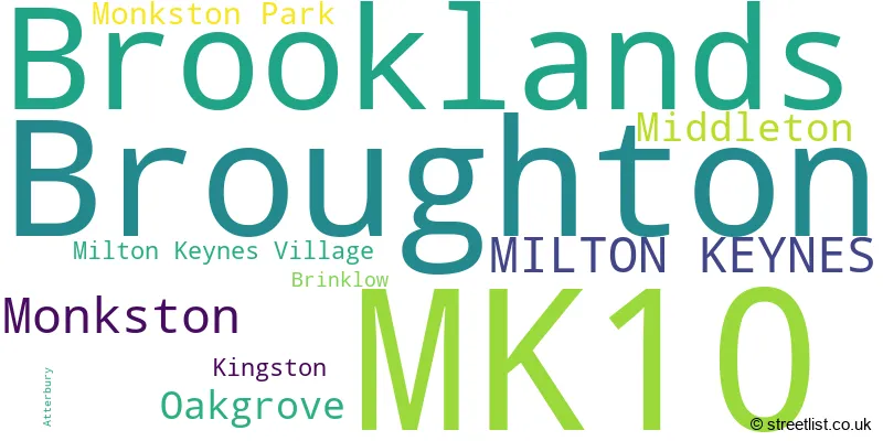
The largest settlement in the MK10 postal code is Broughton followed by Brooklands, and Monkston.
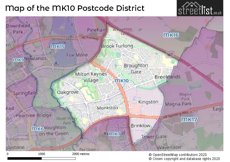
The MK10 Postcode shares a border with MK15 (Willen Park, Willen, Downhead Park), MK17 (Woburn Sands, Glebe Farm, Newton Longville), MK6 (Oldbrook, Fishermead, Netherfield) and MK7 (Walnut Tree, Kents Hill, Wavendon Gate).
In the MK10 postcode district, the primary settlement is Brooklands, located in the county of Buckinghamshire. The post town for MK10 is Milton Keynes. Other significant settlements in the district include Broughton, Monkston, and Oakgrove.
For the district MK10, we have data on 4 postcode sectors. Here's a breakdown: The sector MK10 0, covers Kingston and Brinklow in Buckinghamshire. The sector MK10 1 is non-geographic. It's often designated for PO Boxes, large organisations, or special services. The sector MK10 7, covers Brooklands and Broughton in Buckinghamshire. The sector MK10 9, covers Monkston and Broughton and Middleton and Oakgrove in Buckinghamshire.

Map of the MK10 Postcode District
Explore the MK10 postcode district by using our free interactive map.
When it comes to local government, postal geography often disregards political borders. However, for a breakdown in the MK10 District: the district mostly encompasses the Milton Keynes (B) area with a total of 641 postcodes.
Recent House Sales in MK10
| Date | Price | Address |
|---|---|---|
| 20/10/2023 | £695,000 | Little Hame, Milton Keynes Village, Milton Keynes, MK10 9AN |
| 16/10/2023 | £399,000 | Deacon Place, Middleton, Milton Keynes, MK10 9FR |
| 29/09/2023 | £525,000 | Aiken Grange, Oakgrove, Milton Keynes, MK10 9SR |
| 22/09/2023 | £390,000 | Swithland, Broughton, Milton Keynes, MK10 7BA |
| 20/09/2023 | £360,000 | Laconia Lane, Brooklands, Milton Keynes, MK10 7HW |
| 12/09/2023 | £378,000 | Easby Grove, Monkston, Milton Keynes, MK10 9DT |
| 08/09/2023 | £190,000 | Wingfield Grove, Middleton, Milton Keynes, MK10 9AU |
| 07/09/2023 | £457,860 | Blanchland Circle, Monkston, Milton Keynes, MK10 9DR |
| 04/09/2023 | £600,000 | Wolston Meadow, Middleton, Milton Keynes, MK10 9AY |
| 01/09/2023 | £335,000 | Tanfield Lane, Broughton, Milton Keynes, MK10 9NX |
Weather Forecast for MK10
Press Button to Show Forecast for Woolstone
| Time Period | Icon | Description | Temperature | Rain Probability | Wind |
|---|---|---|---|---|---|
| 21:00 to 00:00 | Clear night | 6.0°C (feels like 3.0°C) | 0.00% | N 7 mph |
Press Button to Show Forecast for Woolstone
| Time Period | Icon | Description | Temperature | Rain Probability | Wind |
|---|---|---|---|---|---|
| 00:00 to 03:00 | Clear night | 4.0°C (feels like 1.0°C) | 0.00% | N 9 mph | |
| 03:00 to 06:00 | Partly cloudy (night) | 3.0°C (feels like 0.0°C) | 1.00% | NNW 7 mph | |
| 06:00 to 09:00 | Partly cloudy (day) | 4.0°C (feels like 1.0°C) | 1.00% | NNW 7 mph | |
| 09:00 to 12:00 | Cloudy | 7.0°C (feels like 4.0°C) | 5.00% | N 11 mph | |
| 12:00 to 15:00 | Cloudy | 10.0°C (feels like 7.0°C) | 4.00% | N 13 mph | |
| 15:00 to 18:00 | Cloudy | 10.0°C (feels like 8.0°C) | 5.00% | N 11 mph | |
| 18:00 to 21:00 | Cloudy | 9.0°C (feels like 7.0°C) | 4.00% | NNE 7 mph | |
| 21:00 to 00:00 | Cloudy | 6.0°C (feels like 5.0°C) | 5.00% | ENE 4 mph |
Press Button to Show Forecast for Woolstone
| Time Period | Icon | Description | Temperature | Rain Probability | Wind |
|---|---|---|---|---|---|
| 00:00 to 03:00 | Cloudy | 5.0°C (feels like 3.0°C) | 5.00% | NNE 4 mph | |
| 03:00 to 06:00 | Overcast | 5.0°C (feels like 3.0°C) | 8.00% | N 4 mph | |
| 06:00 to 09:00 | Overcast | 5.0°C (feels like 3.0°C) | 9.00% | N 7 mph | |
| 09:00 to 12:00 | Overcast | 7.0°C (feels like 4.0°C) | 10.00% | NNE 9 mph | |
| 12:00 to 15:00 | Overcast | 9.0°C (feels like 6.0°C) | 9.00% | NNE 11 mph | |
| 15:00 to 18:00 | Overcast | 10.0°C (feels like 7.0°C) | 12.00% | NNE 11 mph | |
| 18:00 to 21:00 | Partly cloudy (day) | 9.0°C (feels like 6.0°C) | 2.00% | NE 9 mph | |
| 21:00 to 00:00 | Clear night | 6.0°C (feels like 3.0°C) | 2.00% | NE 7 mph |
Press Button to Show Forecast for Woolstone
| Time Period | Icon | Description | Temperature | Rain Probability | Wind |
|---|---|---|---|---|---|
| 00:00 to 03:00 | Clear night | 4.0°C (feels like 1.0°C) | 2.00% | NNE 4 mph | |
| 03:00 to 06:00 | Partly cloudy (night) | 3.0°C (feels like 1.0°C) | 2.00% | N 4 mph | |
| 06:00 to 09:00 | Cloudy | 4.0°C (feels like 2.0°C) | 8.00% | NNW 4 mph | |
| 09:00 to 12:00 | Cloudy | 7.0°C (feels like 6.0°C) | 10.00% | N 4 mph | |
| 12:00 to 15:00 | Overcast | 8.0°C (feels like 7.0°C) | 17.00% | NNE 7 mph | |
| 15:00 to 18:00 | Light rain | 8.0°C (feels like 6.0°C) | 50.00% | NW 7 mph | |
| 18:00 to 21:00 | Light rain | 8.0°C (feels like 6.0°C) | 49.00% | NNW 7 mph | |
| 21:00 to 00:00 | Light rain | 6.0°C (feels like 5.0°C) | 51.00% | NNW 4 mph |
Press Button to Show Forecast for Woolstone
| Time Period | Icon | Description | Temperature | Rain Probability | Wind |
|---|---|---|---|---|---|
| 00:00 to 03:00 | Cloudy | 6.0°C (feels like 4.0°C) | 9.00% | NNE 4 mph | |
| 03:00 to 06:00 | Cloudy | 5.0°C (feels like 3.0°C) | 22.00% | NNE 4 mph | |
| 06:00 to 09:00 | Overcast | 5.0°C (feels like 3.0°C) | 11.00% | NNE 7 mph | |
| 09:00 to 12:00 | Overcast | 8.0°C (feels like 6.0°C) | 10.00% | NNE 9 mph | |
| 12:00 to 15:00 | Overcast | 10.0°C (feels like 8.0°C) | 11.00% | N 9 mph | |
| 15:00 to 18:00 | Cloudy | 11.0°C (feels like 9.0°C) | 15.00% | N 9 mph | |
| 18:00 to 21:00 | Cloudy | 10.0°C (feels like 8.0°C) | 6.00% | NNE 9 mph | |
| 21:00 to 00:00 | Clear night | 7.0°C (feels like 5.0°C) | 2.00% | NNE 7 mph |
Where is the MK10 Postcode District?
The data shows that the MK10 postcode district is located in Milton Keynes. It is situated nearby towns such as Newport Pagnell to the North, Leighton Buzzard to the South, Bedford to the East, Buckingham to the West, Dunstable to the South East, and Towcester to the North West. Additionally, the distance from MK10 to the center of London is approximately 44.28 miles.
The district is within the post town of MILTON KEYNES.
The sector has postcodes within the nation of England.
The MK10 Postcode District is in the Milton Keynes region of Berkshire, Buckinghamshire and Oxfordshire within the South East (England).
| Postcode Sector | Delivery Office |
|---|---|
| MK10 0 | Brinklow (mk) Postal Delivery Office |
| MK10 9 | Brinklow (mk) Postal Delivery Office |
| M | K | 1 | 0 | - | X | X | X |
| M | K | 1 | 0 | Space | Numeric | Letter | Letter |
Current Monthly Rental Prices
| # Bedrooms | Min Price | Max Price | Avg Price |
|---|---|---|---|
| 1 | £1,100 | £1,150 | £1,125 |
| 2 | £1,250 | £2,700 | £1,756 |
| 3 | £1,450 | £3,850 | £2,066 |
| 4 | £1,650 | £2,850 | £2,209 |
| 5 | £2,250 | £3,400 | £2,875 |
Current House Prices
| # Bedrooms | Min Price | Max Price | Avg Price |
|---|---|---|---|
| 1 | £81,000 | £220,000 | £174,911 |
| 2 | £84,100 | £325,000 | £202,824 |
| 3 | £180,000 | £460,000 | £347,407 |
| 4 | £375,000 | £885,000 | £564,388 |
| 5 | £440,000 | £1,275,000 | £650,000 |
| 6 | £725,000 | £790,000 | £746,667 |
Estate Agents who Operate in the MK10 District
| Logo | Name | Brand Name | Address | Contact Number | Total Properties |
|---|---|---|---|---|---|
 | Walnut Tree | Connells | 26A Fyfield Barrow Walnut Tree Milton Keynes MK7 7AN | 01908 103761 | 30 |
 | Milton Keynes | Elevation | Beechwood House, 9 Whittle Court, Knowlhill, Milton Keynes, MK5 8FT | 01908 103259 | 18 |
 | Milton Keynes | Cauldwell Property Services | The Vizion, 350 Avebury Boulevard, Milton Keynes, MK9 2JH | 01908 103401 | 17 |
 | Milton Keynes | King Estate Agents | 11 Furzton Lake Shirwell Crescent Furzton Milton Keynes MK4 1GA | 01908 103362 | 12 |
 | Milton Keynes | Thomas Connolly Estate Agents | 7 Rillaton Walk Milton Keynes MK9 2FZ | 01908 103523 | 11 |
| Type of Property | 2018 Average | 2018 Sales | 2017 Average | 2017 Sales | 2016 Average | 2016 Sales | 2015 Average | 2015 Sales |
|---|---|---|---|---|---|---|---|---|
| Detached | £493,230 | 237 | £436,303 | 197 | £444,905 | 211 | £401,967 | 262 |
| Semi-Detached | £335,993 | 122 | £323,587 | 124 | £301,417 | 117 | £252,919 | 130 |
| Terraced | £286,959 | 108 | £280,485 | 89 | £245,584 | 93 | £246,492 | 144 |
| Flats | £170,291 | 145 | £193,751 | 195 | £184,579 | 261 | £147,348 | 135 |
Hotels within the Postcode Area
We found 2 hotels and guest houses within the MK10 postcode area
Best Western, Milton Keynes
Milton Road, Broughton Village, Milton Keynes, milton-keynes, MK10 9AA.
View detailsSunshine House B&B
34 Canonbury, Monkston Park, Milton Keynes, Buckinghamshire, Milton Keynes, milton-keynes, MK10 9PY.
View details