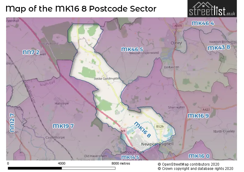
The MK16 8 postcode sector stands on the Buckinghamshire and Northamptonshire border.
Did you know? According to the 2021 Census, the MK16 8 postcode sector is home to a bustling 8,010 residents!
Given that each sector allows for 400 unique postcode combinations. Letters C, I, K, M, O and V are not allowed in the last two letters of a postcode. With 218 postcodes already in use, this leaves 182 units available.
The largest settlement in the MK16 8 postal code is NEWPORT PAGNELL followed by Stoke Goldington, and Gayhurst.
The MK16 8 Postcode shares a border with MK14 5 (Great Linford, Giffard Park, Redhouse Park), MK19 7 (Hanslope, Castlethorpe, Cosgrove), MK46 5 (OLNEY, Emberton, Weston Underwood), MK16 0 (NEWPORT PAGNELL, Moulsoe, Broughton), MK16 9 (NEWPORT PAGNELL, Sherington, North Crawley) and NN7 2 (Roade, Hartwell, Hackleton).
The sector is within the post town of NEWPORT PAGNELL.
MK16 8 is a postcode sector within the MK16 postcode district which is within the MK Milton Keynes postcode area.
The Royal Mail delivery office for the MK16 8 postal sector is the Newport Pagnell Delivery Office.
The area of the MK16 8 postcode sector is 10.39 square miles which is 26.91 square kilometres or 6,648.70 square acres.
The MK16 8 postcode sector is crossed by the M1 motorway.
Waterways within the MK16 8 postcode sector include the River Great Ouse, River Ouzel.

Map of the MK16 8 Postcode Sector
Explore the MK16 8 postcode sector by using our free interactive map.
| M | K | 1 | 6 | - | 8 | X | X |
| M | K | 1 | 6 | Space | 8 | Letter | Letter |
Official List of Streets
NEWPORT PAGNELL (98 Streets)
Stoke Goldington (19 Streets)
Lathbury (2 Streets)
Gayhurst (1 Streets)
Unofficial Streets or Alternative Spellings
NEWPORT PAGNELL
BURY AVENUE BURY STREET CEDARS WAY COOPERS COURT SILVER STREET STATION ROAD DAIRY FARM TUNNEL GAYHURST WOOD BRIDGE HORTON ROAD INN FARM COURT LATHBURY BRIDGE MALTINGS CLOSE PIPPIN CLOSE PORTSFIELDS FARM BRIDGE RAILWAY WALK RAM ALLEY RAM ALLEY (PATH) RIVER SIDE SHERINGTON BRIDGE TICKFORD BRIDGEBlakelands
WOLVERTON ROADWeather Forecast for MK16 8
Press Button to Show Forecast for Newport Pagnell
| Time Period | Icon | Description | Temperature | Rain Probability | Wind |
|---|---|---|---|---|---|
| 12:00 to 15:00 | Light rain | 9.0°C (feels like 6.0°C) | 50.00% | WNW 11 mph | |
| 15:00 to 18:00 | Light rain | 8.0°C (feels like 6.0°C) | 53.00% | NNW 11 mph | |
| 18:00 to 21:00 | Cloudy | 7.0°C (feels like 6.0°C) | 7.00% | ENE 7 mph | |
| 21:00 to 00:00 | Cloudy | 5.0°C (feels like 3.0°C) | 4.00% | ENE 4 mph |
Press Button to Show Forecast for Newport Pagnell
| Time Period | Icon | Description | Temperature | Rain Probability | Wind |
|---|---|---|---|---|---|
| 00:00 to 03:00 | Cloudy | 4.0°C (feels like 2.0°C) | 4.00% | NE 4 mph | |
| 03:00 to 06:00 | Partly cloudy (night) | 2.0°C (feels like 0.0°C) | 1.00% | NE 4 mph | |
| 06:00 to 09:00 | Partly cloudy (day) | 3.0°C (feels like 0.0°C) | 1.00% | NE 4 mph | |
| 09:00 to 12:00 | Partly cloudy (day) | 7.0°C (feels like 5.0°C) | 2.00% | ENE 7 mph | |
| 12:00 to 15:00 | Cloudy | 10.0°C (feels like 9.0°C) | 10.00% | ENE 7 mph | |
| 15:00 to 18:00 | Overcast | 11.0°C (feels like 10.0°C) | 11.00% | NE 4 mph | |
| 18:00 to 21:00 | Cloudy | 9.0°C (feels like 8.0°C) | 10.00% | ENE 7 mph | |
| 21:00 to 00:00 | Cloudy | 6.0°C (feels like 4.0°C) | 10.00% | ENE 7 mph |
Press Button to Show Forecast for Newport Pagnell
| Time Period | Icon | Description | Temperature | Rain Probability | Wind |
|---|---|---|---|---|---|
| 00:00 to 03:00 | Cloudy | 4.0°C (feels like 2.0°C) | 11.00% | ENE 4 mph | |
| 03:00 to 06:00 | Cloudy | 3.0°C (feels like 1.0°C) | 14.00% | ENE 7 mph | |
| 06:00 to 09:00 | Cloudy | 4.0°C (feels like 1.0°C) | 19.00% | NE 7 mph | |
| 09:00 to 12:00 | Overcast | 8.0°C (feels like 6.0°C) | 23.00% | ENE 9 mph | |
| 12:00 to 15:00 | Overcast | 11.0°C (feels like 9.0°C) | 20.00% | ENE 9 mph | |
| 15:00 to 18:00 | Overcast | 11.0°C (feels like 9.0°C) | 21.00% | ENE 11 mph | |
| 18:00 to 21:00 | Cloudy | 10.0°C (feels like 8.0°C) | 21.00% | NE 11 mph | |
| 21:00 to 00:00 | Heavy rain | 8.0°C (feels like 5.0°C) | 73.00% | NE 11 mph |
Press Button to Show Forecast for Newport Pagnell
| Time Period | Icon | Description | Temperature | Rain Probability | Wind |
|---|---|---|---|---|---|
| 00:00 to 03:00 | Heavy rain | 8.0°C (feels like 5.0°C) | 75.00% | NE 11 mph | |
| 03:00 to 06:00 | Heavy rain | 8.0°C (feels like 5.0°C) | 77.00% | NE 9 mph | |
| 06:00 to 09:00 | Heavy rain | 8.0°C (feels like 6.0°C) | 74.00% | ESE 7 mph | |
| 09:00 to 12:00 | Light rain | 10.0°C (feels like 8.0°C) | 50.00% | ESE 9 mph | |
| 12:00 to 15:00 | Heavy rain | 11.0°C (feels like 9.0°C) | 77.00% | SSE 9 mph | |
| 15:00 to 18:00 | Heavy rain shower (day) | 12.0°C (feels like 10.0°C) | 58.00% | W 11 mph | |
| 18:00 to 21:00 | Light rain shower (day) | 11.0°C (feels like 8.0°C) | 35.00% | WSW 9 mph | |
| 21:00 to 00:00 | Partly cloudy (night) | 8.0°C (feels like 7.0°C) | 6.00% | WSW 7 mph |
Schools and Places of Education Within the MK16 8 Postcode Sector
Portfields Primary School
Foundation school
Westbury Lane, Newport Pagnell, Buckinghamshire, MK16 8PS
Head: Mrs Sarah Folkard
Ofsted Rating: Good
Inspection: 2023-04-20 (371 days ago)
Website: Visit Portfields Primary School Website
Phone: 01908616060
Number of Pupils: 626
Stoke Goldington Church of England School
Voluntary controlled school
25 High Street, Newport Pagnell, Buckinghamshire, MK16 8NP
Head: Mrs Emma Wallace
Ofsted Rating: Outstanding
Inspection: 2014-03-05 (3704 days ago)
Website: Visit Stoke Goldington Church of England School Website
Phone: 01908551253
Number of Pupils: 26
House Prices in the MK16 8 Postcode Sector
| Type of Property | 2018 Average | 2018 Sales | 2017 Average | 2017 Sales | 2016 Average | 2016 Sales | 2015 Average | 2015 Sales |
|---|---|---|---|---|---|---|---|---|
| Detached | £442,864 | 33 | £482,183 | 29 | £429,402 | 41 | £404,653 | 43 |
| Semi-Detached | £301,883 | 49 | £301,295 | 54 | £283,821 | 53 | £267,466 | 59 |
| Terraced | £265,356 | 39 | £242,036 | 28 | £258,103 | 29 | £220,445 | 37 |
| Flats | £215,578 | 23 | £187,021 | 22 | £174,134 | 34 | £210,727 | 15 |
Important Postcodes MK16 8 in the Postcode Sector
MK16 8EA is the postcode for Shipley Court, Marsh End Road
MK16 8HQ is the postcode for Newport Pagnell Library, St. John Street
MK16 8PS is the postcode for Portfields Combined School, Westbury Lane
MK16 8QT is the postcode for Newport Pagnell Medical Centre, Queens Avenue, and NEWPORT PAGNELL MEDICAL CENTRE, QUEENS AVENUE, NEWPORT PAGNELL
| The MK16 8 Sector is within these Local Authorities |
|
|---|---|
| The MK16 8 Sector is within these Counties |
|
| The MK16 8 Sector is within these Water Company Areas |
|