The MK17 postcode district is a postal district located in the MK Milton Keynes postcode area with a population of 20,356 residents according to the 2021 England and Wales Census.
The area of the MK17 postcode district is 66.47 square miles which is 172.17 square kilometres or 42,543.45 acres.
Currently, the MK17 district has about 770 postcode units spread across 3 geographic postcode sectors.
Given that each sector allows for 400 unique postcode combinations, the district has a capacity of 1,200 postcodes. With 770 postcodes already in use, this leaves 430 units available.
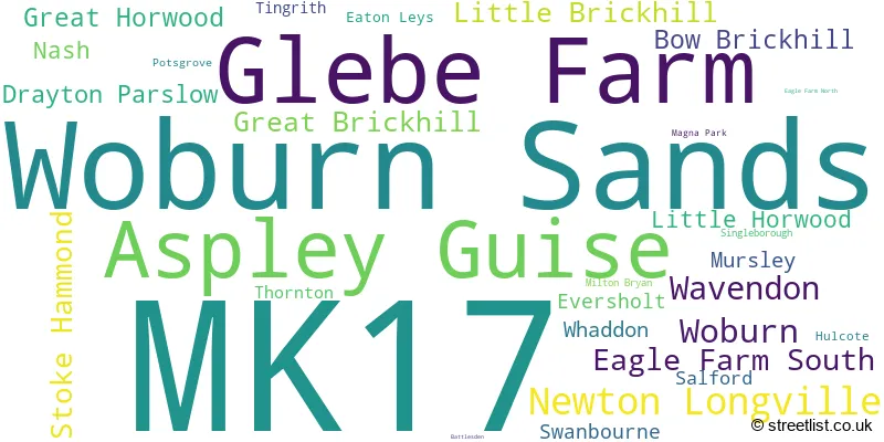
The largest settlement in the MK17 postal code is Woburn Sands followed by Glebe Farm, and Newton Longville.
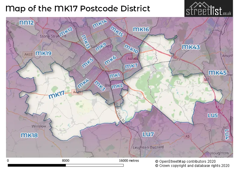
The MK17 Postcode shares a border with LU5 (Houghton Regis, DUNSTABLE, Toddington), LU7 (LEIGHTON BUZZARD, Pitstone, Wing), MK4 (Furzton, Emerson Valley, Tattenhoe), MK5 (Shenley Church End, Shenley Lodge, Loughton), MK8 (Whitehouse, Two Mile Ash, Great Holm), MK43 (Cranfield, Wootton, Marston Moretaine), MK45 (Flitwick, Ampthill, Barton-le-Clay), MK10 (Broughton, Brooklands, Monkston), MK18 (BUCKINGHAM, Winslow, Steeple Claydon), MK2 (Bletchley), MK3 (Bletchley), MK7 (Walnut Tree, Kents Hill, Wavendon Gate), MK16 (NEWPORT PAGNELL, Sherington, North Crawley) and MK19 (Hanslope, Deanshanger, Old Stratford).
In the MK17 postcode district in Buckinghamshire, the primary settlement is Newton Longville, which has the highest count. Other significant settlements include Aspley Guise, Woburn Sands, and Bow Brickhill. The post town for this district is Milton Keynes, located in Buckinghamshire.
For the district MK17, we have data on 4 postcode sectors. Here's a breakdown: The sector MK17 0, covers Newton Longville and Great Horwood and Drayton Parslow and Little Horwood in Buckinghamshire. The sector MK17 7 is non-geographic. It's often designated for PO Boxes, large organisations, or special services. The sector MK17 8, covers Woburn Sands and Glebe Farm and Wavendon in Buckinghamshire. The sector MK17 8, covers Aspley Guise and Woburn Sands in Bedfordshire. The sector MK17 9, covers Woburn in Bedfordshire. The sector MK17 9, covers Little Brickhill and Great Brickhill and Stoke Hammond and Bow Brickhill in Buckinghamshire.

Map of the MK17 Postcode District
Explore the MK17 postcode district by using our free interactive map.
When it comes to local government, postal geography often disregards political borders. However, for a breakdown in the MK17 District: the district mostly encompasses the Milton Keynes (B) (400 postcodes), followed by the Buckinghamshire area (282 postcodes), and finally, the Central Bedfordshire area (202 postcodes).
Recent House Sales in MK17
| Date | Price | Address |
|---|---|---|
| 28/09/2023 | £400,000 | Bettys Close, Newton Longville, Milton Keynes, MK17 0AN |
| 28/09/2023 | £415,000 | Chestnut Close, Newton Longville, Milton Keynes, MK17 0DA |
| 27/09/2023 | £355,000 | Westbrook End, Newton Longville, Milton Keynes, MK17 0DF |
| 15/09/2023 | £440,000 | Haynes Close, Bow Brickhill, Milton Keynes, MK17 9JQ |
| 11/09/2023 | £240,000 | Greensand View, Woburn Sands, Milton Keynes, MK17 8GR |
| 04/09/2023 | £842,500 | Eversden Close, Little Brickhill, Milton Keynes, MK17 9FU |
| 01/09/2023 | £530,000 | Paradise, Newton Longville, Milton Keynes, MK17 0AQ |
| 01/09/2023 | £330,000 | Bragenham Side, Stoke Hammond, Milton Keynes, MK17 9DB |
| 01/09/2023 | £392,000 | Ridgeway Cottages, Swanbourne, Milton Keynes, MK17 0SJ |
| 01/09/2023 | £1,500,000 | Buckingham Road, Singleborough, Milton Keynes, MK17 0RB |
Weather Forecast for MK17
Press Button to Show Forecast for Little Horwood
| Time Period | Icon | Description | Temperature | Rain Probability | Wind |
|---|---|---|---|---|---|
| 12:00 to 15:00 | Cloudy | 9.0°C (feels like 6.0°C) | 51.00% | WNW 11 mph | |
| 15:00 to 18:00 | Cloudy | 9.0°C (feels like 6.0°C) | 37.00% | NNW 11 mph | |
| 18:00 to 21:00 | Cloudy | 7.0°C (feels like 5.0°C) | 7.00% | NE 7 mph | |
| 21:00 to 00:00 | Cloudy | 5.0°C (feels like 3.0°C) | 5.00% | ENE 4 mph |
Press Button to Show Forecast for Little Horwood
| Time Period | Icon | Description | Temperature | Rain Probability | Wind |
|---|---|---|---|---|---|
| 00:00 to 03:00 | Cloudy | 4.0°C (feels like 1.0°C) | 4.00% | ENE 4 mph | |
| 03:00 to 06:00 | Partly cloudy (night) | 2.0°C (feels like -1.0°C) | 1.00% | ENE 4 mph | |
| 06:00 to 09:00 | Partly cloudy (day) | 2.0°C (feels like 0.0°C) | 1.00% | NE 7 mph | |
| 09:00 to 12:00 | Partly cloudy (day) | 7.0°C (feels like 4.0°C) | 2.00% | ENE 7 mph | |
| 12:00 to 15:00 | Cloudy | 9.0°C (feels like 8.0°C) | 10.00% | ENE 7 mph | |
| 15:00 to 18:00 | Overcast | 10.0°C (feels like 9.0°C) | 11.00% | NE 4 mph | |
| 18:00 to 21:00 | Cloudy | 9.0°C (feels like 7.0°C) | 10.00% | ENE 7 mph | |
| 21:00 to 00:00 | Cloudy | 5.0°C (feels like 3.0°C) | 11.00% | ENE 7 mph |
Press Button to Show Forecast for Little Horwood
| Time Period | Icon | Description | Temperature | Rain Probability | Wind |
|---|---|---|---|---|---|
| 00:00 to 03:00 | Cloudy | 4.0°C (feels like 1.0°C) | 12.00% | ENE 7 mph | |
| 03:00 to 06:00 | Cloudy | 3.0°C (feels like 0.0°C) | 15.00% | ENE 7 mph | |
| 06:00 to 09:00 | Cloudy | 3.0°C (feels like 1.0°C) | 18.00% | NE 7 mph | |
| 09:00 to 12:00 | Cloudy | 7.0°C (feels like 5.0°C) | 18.00% | ENE 9 mph | |
| 12:00 to 15:00 | Overcast | 10.0°C (feels like 8.0°C) | 21.00% | ENE 11 mph | |
| 15:00 to 18:00 | Overcast | 11.0°C (feels like 9.0°C) | 20.00% | ENE 11 mph | |
| 18:00 to 21:00 | Cloudy | 10.0°C (feels like 7.0°C) | 20.00% | NE 11 mph | |
| 21:00 to 00:00 | Light rain | 7.0°C (feels like 4.0°C) | 53.00% | NE 11 mph |
Press Button to Show Forecast for Little Horwood
| Time Period | Icon | Description | Temperature | Rain Probability | Wind |
|---|---|---|---|---|---|
| 00:00 to 03:00 | Heavy rain | 7.0°C (feels like 4.0°C) | 74.00% | NE 11 mph | |
| 03:00 to 06:00 | Heavy rain | 7.0°C (feels like 4.0°C) | 74.00% | NE 9 mph | |
| 06:00 to 09:00 | Heavy rain | 8.0°C (feels like 6.0°C) | 76.00% | ESE 7 mph | |
| 09:00 to 12:00 | Light rain | 10.0°C (feels like 7.0°C) | 51.00% | ESE 9 mph | |
| 12:00 to 15:00 | Heavy rain | 11.0°C (feels like 9.0°C) | 74.00% | SSE 9 mph | |
| 15:00 to 18:00 | Light rain shower (day) | 11.0°C (feels like 9.0°C) | 43.00% | SW 11 mph | |
| 18:00 to 21:00 | Light rain shower (day) | 10.0°C (feels like 8.0°C) | 35.00% | SW 9 mph | |
| 21:00 to 00:00 | Partly cloudy (night) | 7.0°C (feels like 6.0°C) | 7.00% | SW 7 mph |
Where is the MK17 Postcode District?
The MK17 postcode district is located in Milton Keynes. It is situated near various towns, including Leighton Buzzard to the South East, Newport Pagnell to the North, Buckingham to the West, Aylesbury to the South West, Tring to the South, and Bedford to the North East. Additionally, the distance from MK17 to the center of London is approximately 41.64 miles.
The district is within the post town of MILTON KEYNES.
The sector has postcodes within the nation of England.
The MK17 Postcode District is covers the following regions.
- Milton Keynes - Berkshire, Buckinghamshire and Oxfordshire - South East (England)
- Central Bedfordshire - Bedfordshire and Hertfordshire - East of England
| Postcode Sector | Delivery Office |
|---|---|
| MK17 0 | Mursley Scale Payment Delivery Office |
| MK17 0 | Brinklow (mk) Postal Delivery Office |
| MK17 0 | Great Horwood Scale Payment Delivery Office |
| MK17 8 | Aspley Guise Scale Payment Delivery Office |
| MK17 8 | Brinklow (mk) Postal Delivery Office |
| MK17 9 | Brinklow (mk) Postal Delivery Office |
| MK17 9 | Woburn Scale Payment Delivery Office |
| MK17 9 | Little Brickhill Scale Payment Delivery Office |
| M | K | 1 | 7 | - | X | X | X |
| M | K | 1 | 7 | Space | Numeric | Letter | Letter |
Tourist Attractions within the Postcode Area
We found 1 visitor attractions within the MK17 postcode area
| Go Ape! Tree Top Adventure - Woburn Safari Park |
|---|
| Country Parks |
| Country Park |
| View Go Ape! Tree Top Adventure - Woburn Safari Park on Google Maps |
Current Monthly Rental Prices
| # Bedrooms | Min Price | Max Price | Avg Price |
|---|---|---|---|
| 1 | £750 | £750 | £750 |
| 2 | £1,100 | £1,295 | £1,198 |
| 3 | £1,500 | £2,250 | £1,850 |
| 4 | £1,300 | £3,500 | £2,154 |
| 5 | £2,650 | £2,650 | £2,650 |
Current House Prices
| # Bedrooms | Min Price | Max Price | Avg Price |
|---|---|---|---|
| £175,000 | £1,950,000 | £880,000 | |
| 1 | £87,000 | £350,000 | £173,340 |
| 2 | £101,000 | £550,000 | £333,397 |
| 3 | £300,000 | £4,000,000 | £506,536 |
| 4 | £375,000 | £3,500,000 | £699,057 |
| 5 | £400,000 | £2,500,000 | £1,047,606 |
| 6 | £859,995 | £5,000,000 | £2,211,000 |
| 7 | £950,000 | £2,500,000 | £1,841,667 |
Estate Agents who Operate in the MK17 District
| Logo | Name | Brand Name | Address | Contact Number | Total Properties |
|---|---|---|---|---|---|
 | Woburn | Jackson-Stops | 1 Market Place, Woburn, MK17 9PZ | 01525 302098 | 28 |
 | Woburn Sands | Beasley & Partners | 6 High Street, Woburn Sands, MK17 8RL | 01908 103508 | 27 |
 | Woburn Sands | Brown & Merry | 9 High Street, Woburn Sands, Buckinghamshire, MK17 8RG | 01908 103657 | 25 |
 | Woburn Sands | Michael Graham | 2 Aspley Hill, Woburn Sands, Woburn Sands, MK17 8NJ | 01908 103197 | 22 |
 | Winslow | The Wilkinson Partnership | 12 Market Square, Winslow, Buckinghamshire, MK18 3AF | 01280 733259 | 15 |
- Aspley Guise
- Aspley Heath
- Birchmoor Green
- Bletchley
- Bow Brickhill
- Brogborough
- Drayton Parslow
- Eversholt
- Great Brickhill
- Great Horwood
- Leighton Buzzard
- Little Brickhill
- Little Horwood
- Lower End
- Milton Bryan
- Milton Keynes
- Mursley
- Nash
- Newton Longville
- Salford
- Sheeplane
- Stoke Hammond
- Swanbourne
- Thornborough
- Thornton
- Tingrith
- Wavendon
- Westoning
- Whaddon
- Winslow
- Woburn
- Woburn Sands
| Type of Property | 2018 Average | 2018 Sales | 2017 Average | 2017 Sales | 2016 Average | 2016 Sales | 2015 Average | 2015 Sales |
|---|---|---|---|---|---|---|---|---|
| Detached | £681,901 | 119 | £666,411 | 150 | £575,907 | 143 | £619,945 | 157 |
| Semi-Detached | £373,519 | 98 | £384,995 | 81 | £343,253 | 107 | £326,374 | 99 |
| Terraced | £317,915 | 59 | £329,780 | 52 | £300,958 | 62 | £270,149 | 83 |
| Flats | £210,441 | 43 | £205,339 | 40 | £191,934 | 38 | £221,498 | 53 |