The MK43 0 postcode sector stands on the Bedfordshire and Buckinghamshire border.
Did you know? According to the 2021 Census, the MK43 0 postcode sector is home to a bustling 15,407 residents!
Given that each sector allows for 400 unique postcode combinations. Letters C, I, K, M, O and V are not allowed in the last two letters of a postcode. With 371 postcodes already in use, this leaves 29 units available.
The largest settlement in the MK43 0 postal code is Cranfield followed by Marston Moretaine, and Lidlington.
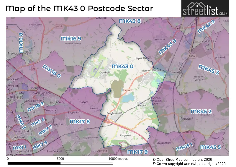
The MK43 0 Postcode shares a border with MK17 8 (Woburn Sands, Glebe Farm, Aspley Guise), MK17 9 (Woburn, Stoke Hammond, Great Brickhill), MK43 8 (Bromham, Turvey, Stagsden), MK43 9 (Wootton, Stewartby, Kempston), MK45 2 (Ampthill, Maulden, Millbrook), MK45 5 (Westoning, Pulloxhill, Flitton), MK16 0 (NEWPORT PAGNELL, Moulsoe, Broughton) and MK16 9 (NEWPORT PAGNELL, Sherington, North Crawley).
The sector is within the post town of BEDFORD.
MK43 0 is a postcode sector within the MK43 postcode district which is within the MK Milton Keynes postcode area.
The Royal Mail delivery office for the MK43 0 postal sector is the Bedford Rurals Delivery Office (mk) and Cranfield Scale Payment Delivery Office and Marston Moreteyne Scale Payment Delivery Office.
The area of the MK43 0 postcode sector is 21.75 square miles which is 56.33 square kilometres or 13,919.67 square acres.
The MK43 0 postcode sector is crossed by the M1 motorway.
The MK43 0 postcode sector is crossed by the A421 Major A road.

Map of the MK43 0 Postcode Sector
Explore the MK43 0 postcode sector by using our free interactive map.
| M | K | 4 | 3 | - | 0 | X | X |
| M | K | 4 | 3 | Space | 0 | Letter | Letter |
Official List of Streets
Marston Moretaine (90 Streets)
Cranfield (99 Streets)
Lidlington (34 Streets)
Ridgmont (13 Streets)
Brogborough (6 Streets)
Unofficial Streets or Alternative Spellings
North Crawley
FOLLY LANEEversholt
BERRY ENDAstwood
CRANFIELD ROADAspley Guise
BEDFORD ROADHulcote
CRANFIELD ROADMoulsoe
CRANFIELD ROADWeather Forecast for MK43 0
Press Button to Show Forecast for Cranfield
| Time Period | Icon | Description | Temperature | Rain Probability | Wind |
|---|---|---|---|---|---|
| 00:00 to 03:00 | Partly cloudy (night) | 5.0°C (feels like 2.0°C) | 5.00% | WNW 7 mph | |
| 03:00 to 06:00 | Clear night | 4.0°C (feels like 0.0°C) | 2.00% | WNW 11 mph | |
| 06:00 to 09:00 | Sunny day | 4.0°C (feels like 0.0°C) | 1.00% | NW 11 mph | |
| 09:00 to 12:00 | Partly cloudy (day) | 7.0°C (feels like 3.0°C) | 2.00% | NW 16 mph | |
| 12:00 to 15:00 | Cloudy | 10.0°C (feels like 7.0°C) | 9.00% | NW 16 mph | |
| 15:00 to 18:00 | Cloudy | 10.0°C (feels like 7.0°C) | 12.00% | NW 16 mph | |
| 18:00 to 21:00 | Cloudy | 8.0°C (feels like 5.0°C) | 13.00% | NNW 11 mph | |
| 21:00 to 00:00 | Partly cloudy (night) | 5.0°C (feels like 3.0°C) | 5.00% | NNW 9 mph |
Press Button to Show Forecast for Cranfield
| Time Period | Icon | Description | Temperature | Rain Probability | Wind |
|---|---|---|---|---|---|
| 00:00 to 03:00 | Partly cloudy (night) | 4.0°C (feels like 1.0°C) | 3.00% | NNW 9 mph | |
| 03:00 to 06:00 | Partly cloudy (night) | 3.0°C (feels like 1.0°C) | 2.00% | NNW 7 mph | |
| 06:00 to 09:00 | Cloudy | 4.0°C (feels like 1.0°C) | 6.00% | NNW 7 mph | |
| 09:00 to 12:00 | Partly cloudy (day) | 8.0°C (feels like 6.0°C) | 4.00% | NNW 7 mph | |
| 12:00 to 15:00 | Cloudy | 10.0°C (feels like 9.0°C) | 7.00% | WNW 9 mph | |
| 15:00 to 18:00 | Cloudy | 12.0°C (feels like 10.0°C) | 7.00% | W 11 mph | |
| 18:00 to 21:00 | Overcast | 11.0°C (feels like 9.0°C) | 13.00% | WSW 11 mph | |
| 21:00 to 00:00 | Light rain | 8.0°C (feels like 6.0°C) | 48.00% | WSW 11 mph |
Press Button to Show Forecast for Cranfield
| Time Period | Icon | Description | Temperature | Rain Probability | Wind |
|---|---|---|---|---|---|
| 00:00 to 03:00 | Light rain | 8.0°C (feels like 5.0°C) | 43.00% | WSW 13 mph | |
| 03:00 to 06:00 | Cloudy | 8.0°C (feels like 5.0°C) | 10.00% | W 13 mph | |
| 06:00 to 09:00 | Overcast | 8.0°C (feels like 5.0°C) | 10.00% | WNW 13 mph | |
| 09:00 to 12:00 | Cloudy | 10.0°C (feels like 7.0°C) | 9.00% | NW 18 mph | |
| 12:00 to 15:00 | Cloudy | 12.0°C (feels like 8.0°C) | 10.00% | NW 18 mph | |
| 15:00 to 18:00 | Cloudy | 12.0°C (feels like 9.0°C) | 6.00% | NNW 18 mph | |
| 18:00 to 21:00 | Cloudy | 11.0°C (feels like 8.0°C) | 7.00% | NNW 13 mph | |
| 21:00 to 00:00 | Clear night | 7.0°C (feels like 5.0°C) | 2.00% | N 9 mph |
Press Button to Show Forecast for Cranfield
| Time Period | Icon | Description | Temperature | Rain Probability | Wind |
|---|---|---|---|---|---|
| 00:00 to 03:00 | Clear night | 6.0°C (feels like 3.0°C) | 1.00% | N 9 mph | |
| 03:00 to 06:00 | Partly cloudy (night) | 5.0°C (feels like 2.0°C) | 2.00% | NNW 7 mph | |
| 06:00 to 09:00 | Partly cloudy (day) | 5.0°C (feels like 2.0°C) | 2.00% | NNW 7 mph | |
| 09:00 to 12:00 | Cloudy | 8.0°C (feels like 6.0°C) | 4.00% | N 11 mph | |
| 12:00 to 15:00 | Overcast | 11.0°C (feels like 9.0°C) | 7.00% | N 11 mph | |
| 15:00 to 18:00 | Overcast | 12.0°C (feels like 10.0°C) | 8.00% | N 11 mph | |
| 18:00 to 21:00 | Sunny day | 11.0°C (feels like 10.0°C) | 2.00% | N 7 mph | |
| 21:00 to 00:00 | Clear night | 7.0°C (feels like 5.0°C) | 1.00% | NE 4 mph |
Schools and Places of Education Within the MK43 0 Postcode Sector
Cranfield Church of England Academy
Academy converter
Court Road, Bedford, Bedfordshire, MK43 0DR
Head: Mrs Lisa Munday
Ofsted Rating: Good
Inspection: 2019-09-18 (1673 days ago)
Website: Visit Cranfield Church of England Academy Website
Phone: 01234750261
Number of Pupils: 527
Holywell School
Academy converter
Red Lion Close, Bedford, Bedfordshire, MK43 0JA
Head: Headteacher Michael Simpson
Ofsted Rating: Good
Inspection: 2023-07-12 (280 days ago)
Website: Visit Holywell School Website
Phone: 01234750381
Number of Pupils: 719
Husborne Crawley Lower School
Community school
School Lane, Husborne Crawley, Bedfordshire, MK43 0UZ
Head: Mrs Deborah Willans
Ofsted Rating: Good
Inspection: 2023-05-05 (348 days ago)
Website: Visit Husborne Crawley Lower School Website
Phone: 01525280232
Number of Pupils: 49
Ridgmont Lower School
Community school
High Street, Bedford, Bedfordshire, MK43 0TS
Head: Mrs Allison Jakes
Ofsted Rating: Requires improvement
Inspection: 2023-06-21 (301 days ago)
Website: Visit Ridgmont Lower School Website
Phone: 01525280236
Number of Pupils: 28
Shelton Lower School
Foundation school
Lower Shelton Road, Beds, Bedfordshire, MK43 0LS
Head: Mrs Jane Anderson
Ofsted Rating: Good
Inspection: 2016-11-09 (2716 days ago)
Website: Visit Shelton Lower School Website
Phone: 01234768269
Number of Pupils: 0
Thomas Johnson Lower School
Community school
Hurst Grove, Bedford, Bedfordshire, MK43 0SB
Head: Mr Simon Bolger
Ofsted Rating: Good
Inspection: 2022-11-24 (510 days ago)
Website: Visit Thomas Johnson Lower School Website
Phone: 01525402377
Number of Pupils: 96
House Prices in the MK43 0 Postcode Sector
| Type of Property | 2018 Average | 2018 Sales | 2017 Average | 2017 Sales | 2016 Average | 2016 Sales | 2015 Average | 2015 Sales |
|---|---|---|---|---|---|---|---|---|
| Detached | £432,126 | 146 | £413,695 | 166 | £380,965 | 190 | £339,515 | 182 |
| Semi-Detached | £272,306 | 112 | £259,947 | 134 | £259,731 | 109 | £250,111 | 132 |
| Terraced | £253,658 | 80 | £240,911 | 72 | £247,687 | 136 | £242,979 | 90 |
| Flats | £154,749 | 6 | £172,312 | 8 | £147,760 | 14 | £155,142 | 7 |
Important Postcodes MK43 0 in the Postcode Sector
MK43 0AL is the postcode for BUILDING 108, Cranfield University, College Road, BUILDING 6, Cranfield University, College Road, BUILDING 32, Cranfield University, College Road, BUILDING 7, Cranfield University, College Road, B320 AIRC, Cranfield University, College Road, BUILDING 11, Cranfield University, College Road, BUILDING 125, Cranfield University, College Road, CMDC BUILDINGS 239 & 240, Cranfield University, College Road, BUILDING 26, Cranfield University, College Road, BUILDING 111, Cranfield University, College Road, BUILDING 61, Cranfield University, College Road, BUILDING 227, Cranfield University, College Road, BUILDING 15, Cranfield University, College Road, BUILDING 228, Cranfield University, College Road, BUILDING 63, Cranfield University, College Road, THE ENERGY TECHNOLOGY CENTRE BUILDING 43A, Cranfield University, College Road, BUILDING 84, Cranfield University, College Road, BUILDING 122, Cranfield University, College Road, BUILDING 8, Cranfield University, College Road, BUILDING 12, Cranfield University, College Road, BUILDING 39, Cranfield University, College Road, BUILDING 57, Cranfield University, College Road, BUILDING 3, Cranfield University, College Road, BUILDING 52, Cranfield University, College Road, BUILDING 9 CHILVER 1, Cranfield University, College Road, BUILDING 62, Cranfield University, College Road, BUILDING 14, Cranfield University, College Road, BUILDING 225, Cranfield University, College Road, STAFFORD CRIPPS BUILDING 41, Cranfield University, College Road, BUILDING 52A, Cranfield University, College Road, BUILDING 33 RELIGIOUS FACILITIES, Cranfield University, College Road, CAMPUS, Cranfield University, College Road, BUILDING 114, Cranfield University, College Road, BUILDING 20, Cranfield University, College Road, BUILDING 50, Cranfield University, College Road, BUILDING 23, Cranfield University, College Road, BUILDING 42, Cranfield University, College Road, C4D BUILDING, Cranfield University, College Road, BUILDING 31, Cranfield University, College Road, BUILDING 16, Cranfield University, College Road, B320 AEROSPACE INTEGRATION RESEARCH CENTRE, Cranfield University, College Road, BUILDING 30, Cranfield University, College Road, BUILDING 46, Cranfield University, College Road, BUILDING 22, Cranfield University, College Road, MITCHELL HALL, Cranfield University, College Road, BUILDING 5, Cranfield University, College Road, BUILDING 85, Cranfield University, College Road, BUILDING 83, Cranfield University, College Road, BUILDING 19, Cranfield University, College Road, BUILDING 244, Cranfield University, College Road, BUILDING 38, Cranfield University, College Road, BUILDING 56, Cranfield University, College Road, BUILDING 88, Cranfield University, College Road, BUILDING 72, Cranfield University, College Road, BUILDING 237, Cranfield University, College Road, BUILDING 70, Cranfield University, College Road, BUILDING 54, Cranfield University, College Road, BUILDING 226, Cranfield University, College Road, BUILDING 4, Cranfield University, College Road, BUILDING 115, Cranfield University, College Road, BUILDING 40, Cranfield University, College Road, LIBRARY - BUILDING 55, Cranfield University, College Road, BUILDING 90, Cranfield University, College Road, BUILDING 53, Cranfield University, College Road, BUILDING 13, Cranfield University, College Road, and BUILDING 229, Cranfield University, College Road
MK43 0DD is the postcode for Church End Lower School, Forest End Site, Great Linns, MAIN BUILDING, MARSTON MORETEYNE CHUCH OF ENGLAND VC SCHOOL, FOREST END, and NEW BUILDING, MARSTON MORETEYNE CHUCH OF ENGLAND VC SCHOOL, FOREST END
MK43 0DR is the postcode for ST PETER SITE, Cranfield Church of England Academy, Court Road, and Cranfield Church of England Academy, Court Road
MK43 0EH is the postcode for ST PAUL SITE, Cranfield Church of England Academy, Braeburn Way
MK43 0FQ is the postcode for C311, Unit 1 Medway Court, University Way
MK43 0JA is the postcode for Holywell Middle School, Red Lion Close, BLOCK 4, Holywell Middle School, Red Lion Close, and BLOCK 1, Holywell Middle School, Red Lion Close
MK43 0NE is the postcode for Marston Moreteyne CofE VC School, Church Walk, and MARSTON MORETEYNE CHURCH OF ENGLAND VC SCHOOL, CHURCH WALK, MARSTON MORETAINE
MK43 0SB is the postcode for Thomas Johnson Lower School, Hurst Grove
MK43 0TR is the postcode for BUILDING 300, Cranfield University, Martell House
MK43 0TS is the postcode for Ridgmont Lower School, High Street
| The MK43 0 Sector is within these Local Authorities |
|
|---|---|
| The MK43 0 Sector is within these Counties |
|
| The MK43 0 Sector is within these Water Company Areas |
|