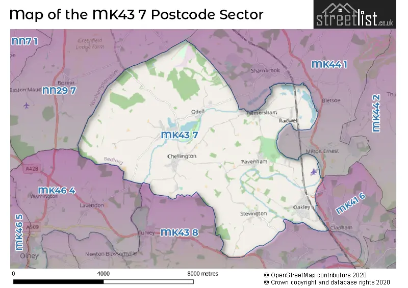
The MK43 7 postcode sector lies where the three counties of Bedfordshire, Buckinghamshire, and Northamptonshire meet.
Did you know? According to the 2021 Census, the MK43 7 postcode sector is home to a bustling 7,348 residents!
Given that each sector allows for 400 unique postcode combinations. Letters C, I, K, M, O and V are not allowed in the last two letters of a postcode. With 214 postcodes already in use, this leaves 186 units available.
The largest settlement in the MK43 7 postal code is Oakley followed by Harrold, and Carlton.
The MK43 7 Postcode shares a border with MK43 8 (Bromham, Turvey, Stagsden), MK44 1 (Sharnbrook, Riseley, Milton Ernest), MK46 4 (OLNEY, Lavendon, Cold Brayfield), NN29 7 (Irchester, Wollaston, Bozeat) and MK41 6 (Clapham).
The sector is within the post town of BEDFORD.
MK43 7 is a postcode sector within the MK43 postcode district which is within the MK Milton Keynes postcode area.
The Royal Mail delivery office for the MK43 7 postal sector is the Harrold Scale Payment Delivery Office and Oakley Scale Payment Delivery Office and Carlton (mk) Scale Payment Delivery Office and Stevington Scale Payment Delivery Office and Bedford Rurals Delivery Office (mk).
The area of the MK43 7 postcode sector is 22.41 square miles which is 58.05 square kilometres or 14,344.14 square acres.
Waterways within the MK43 7 postcode sector include the River Great Ouse, River Ouse.

Map of the MK43 7 Postcode Sector
Explore the MK43 7 postcode sector by using our free interactive map.
| M | K | 4 | 3 | - | 7 | X | X |
| M | K | 4 | 3 | Space | 7 | Letter | Letter |
Official List of Streets
Harrold (25 Streets)
Pavenham (17 Streets)
Carlton (16 Streets)
Oakley (27 Streets)
Radwell (5 Streets)
Stevington (11 Streets)
Felmersham (17 Streets)
Unofficial Streets or Alternative Spellings
Clapham
MILTON ROAD OAKLEY ROAD BARTON PETROLEUM BRANLEY COURT CAUSEWAY COUNTRY WALK FEMERSHAM FP 6A FORTY FOOT LANE HARROLD PLACE HIGH ELMS HIGHFIELD COURT HIGHFIELD PARC LOVELL HOMES MONKS ROW OAKLEY ROAD PAULA RADCLIFFE WAY PIPERS HIGHWAY RADWELL BRIDGE SANTA POD DRAG STRIP STAFFORD BRIDGE STATION COTTAGES STEVINGTON COUNTRY WALK THE DRIVE THE SLIP WHITE LANEMilton Ernest
BEDFORD ROADTurvey
BEDFORD ROAD STAGSDEN ROADSharnbrook
YELNOW LANEPodington
AIRFIELD ROADBromham
NORTHAMPTON ROADLavendon
HARROLD ROADWeather Forecast for MK43 7
Press Button to Show Forecast for Harrold
| Time Period | Icon | Description | Temperature | Rain Probability | Wind |
|---|---|---|---|---|---|
| 15:00 to 18:00 | Light rain | 8.0°C (feels like 6.0°C) | 52.00% | N 9 mph | |
| 18:00 to 21:00 | Cloudy | 7.0°C (feels like 5.0°C) | 8.00% | ENE 7 mph | |
| 21:00 to 00:00 | Partly cloudy (night) | 5.0°C (feels like 3.0°C) | 1.00% | ENE 4 mph |
Press Button to Show Forecast for Harrold
| Time Period | Icon | Description | Temperature | Rain Probability | Wind |
|---|---|---|---|---|---|
| 00:00 to 03:00 | Clear night | 2.0°C (feels like 0.0°C) | 1.00% | ENE 4 mph | |
| 03:00 to 06:00 | Clear night | 1.0°C (feels like -1.0°C) | 1.00% | NNE 4 mph | |
| 06:00 to 09:00 | Sunny day | 2.0°C (feels like 0.0°C) | 1.00% | NNE 4 mph | |
| 09:00 to 12:00 | Sunny day | 7.0°C (feels like 5.0°C) | 2.00% | ENE 7 mph | |
| 12:00 to 15:00 | Cloudy | 10.0°C (feels like 9.0°C) | 10.00% | ENE 4 mph | |
| 15:00 to 18:00 | Overcast | 10.0°C (feels like 9.0°C) | 10.00% | ENE 7 mph | |
| 18:00 to 21:00 | Cloudy | 9.0°C (feels like 7.0°C) | 11.00% | ENE 7 mph | |
| 21:00 to 00:00 | Cloudy | 6.0°C (feels like 3.0°C) | 10.00% | ENE 7 mph |
Press Button to Show Forecast for Harrold
| Time Period | Icon | Description | Temperature | Rain Probability | Wind |
|---|---|---|---|---|---|
| 00:00 to 03:00 | Cloudy | 4.0°C (feels like 2.0°C) | 11.00% | ENE 7 mph | |
| 03:00 to 06:00 | Cloudy | 3.0°C (feels like 1.0°C) | 13.00% | NE 7 mph | |
| 06:00 to 09:00 | Cloudy | 4.0°C (feels like 2.0°C) | 16.00% | NE 7 mph | |
| 09:00 to 12:00 | Light rain | 8.0°C (feels like 6.0°C) | 47.00% | ENE 9 mph | |
| 12:00 to 15:00 | Overcast | 11.0°C (feels like 9.0°C) | 23.00% | ENE 9 mph | |
| 15:00 to 18:00 | Overcast | 11.0°C (feels like 9.0°C) | 20.00% | ENE 11 mph | |
| 18:00 to 21:00 | Overcast | 10.0°C (feels like 7.0°C) | 24.00% | NE 11 mph | |
| 21:00 to 00:00 | Light rain | 8.0°C (feels like 5.0°C) | 55.00% | NE 11 mph |
Press Button to Show Forecast for Harrold
| Time Period | Icon | Description | Temperature | Rain Probability | Wind |
|---|---|---|---|---|---|
| 00:00 to 03:00 | Light rain | 7.0°C (feels like 4.0°C) | 53.00% | NE 11 mph | |
| 03:00 to 06:00 | Heavy rain | 8.0°C (feels like 5.0°C) | 79.00% | NE 11 mph | |
| 06:00 to 09:00 | Heavy rain | 9.0°C (feels like 6.0°C) | 76.00% | ESE 9 mph | |
| 09:00 to 12:00 | Light rain | 10.0°C (feels like 8.0°C) | 50.00% | S 11 mph | |
| 12:00 to 15:00 | Light rain shower (day) | 12.0°C (feels like 10.0°C) | 43.00% | SSW 9 mph | |
| 15:00 to 18:00 | Heavy rain shower (day) | 12.0°C (feels like 10.0°C) | 61.00% | W 11 mph | |
| 18:00 to 21:00 | Light rain shower (day) | 11.0°C (feels like 8.0°C) | 36.00% | WSW 11 mph | |
| 21:00 to 00:00 | Cloudy | 8.0°C (feels like 6.0°C) | 8.00% | WSW 7 mph |
Schools and Places of Education Within the MK43 7 Postcode Sector
Carlton CofE Primary School
Voluntary controlled school
The Moor, Bedford, Bedfordshire, MK43 7JR
Head: Mrs Jo Bevis
Ofsted Rating: Outstanding
Inspection: 2013-01-30 (4103 days ago)
Website: Visit Carlton CofE Primary School Website
Phone: 01234720281
Number of Pupils: 94
Harrold Primary Academy
Academy converter
The Green, Bedford, Bedfordshire, MK43 7DB
Head: Ms Debonair Brown
Ofsted Rating: Good
Inspection: 2023-09-21 (217 days ago)
Website: Visit Harrold Primary Academy Website
Phone: 01234720346
Number of Pupils: 116
Lincroft Academy
Academy converter
Station Road, Bedford, Bedfordshire, MK43 7RE
Head: Ms Emma Appadoo
Ofsted Rating: Requires improvement
Inspection: 2022-02-24 (791 days ago)
Website: Visit Lincroft Academy Website
Phone: 01234822147
Number of Pupils: 1007
Oakley Primary Academy
Academy converter
Station Road, Bedford, Bedfordshire, MK43 7RE
Head: Mr Callum Brown
Ofsted Rating: Good
Inspection: 2019-10-03 (1666 days ago)
Website: Visit Oakley Primary Academy Website
Phone: 01234822104
Number of Pupils: 286
Pinchmill Primary School
Foundation school
The Old Road, Bedford, Bedfordshire, MK43 7JD
Head: Mrs Victoria Bailey
Ofsted Rating: Good
Inspection: 2023-11-01 (176 days ago)
Website: Visit Pinchmill Primary School Website
Phone: 01234781371
Number of Pupils: 93
House Prices in the MK43 7 Postcode Sector
| Type of Property | 2018 Average | 2018 Sales | 2017 Average | 2017 Sales | 2016 Average | 2016 Sales | 2015 Average | 2015 Sales |
|---|---|---|---|---|---|---|---|---|
| Detached | £470,866 | 53 | £521,414 | 52 | £449,734 | 48 | £469,353 | 48 |
| Semi-Detached | £302,224 | 29 | £323,122 | 41 | £282,602 | 29 | £279,721 | 34 |
| Terraced | £260,322 | 24 | £283,780 | 23 | £254,431 | 30 | £228,862 | 34 |
| Flats | £165,000 | 3 | £130,083 | 6 | £145,929 | 7 | £125,500 | 2 |
Important Postcodes MK43 7 in the Postcode Sector
MK43 7DB is the postcode for Watson Building, Harrold Primary Academy, The Green, Science Building, Harrold Primary Academy, The Green, and ITT Conservatory, Harrold Primary Academy, The Green
MK43 7DE is the postcode for WATSON, Harrold Primary School, Mowhills, BLOCK 3, Harrold Primary Academy, Mowhills, BLOCK 1, Harrold Primary Academy, Mowhills, Harrold Primary Academy, Mowhills, BLOCK 6, Harrold Primary Academy, Mowhills, and LOWER SCHOOL BLOCK, Harrold Primary Academy, Mowhills
MK43 7DH is the postcode for Bedfordshire & Luton Fire & Rescue Service, Fire Station, Odell Road
MK43 7DX is the postcode for Harrold Medical Practice, Peachs Close
MK43 7JD is the postcode for Pinchmill School, The Old Road, and Pinchmill Primary School, The Old Road
MK43 7JR is the postcode for Carlton Lower School, The Moor
MK43 7RE is the postcode for BLOCK 1, Lincroft Academy, Station Road, Main Block, Oakley Primary Academy, Station Road, Modular Classroom, Oakley Primary Academy, Station Road, OAK BLOCK, Lincroft Academy, Station Road, Lincroft Academy, Station Road, Woodland Building, Oakley Primary Academy, Station Road, Oakley Primary Academy, Station Road, and Main Building, Lincroft Academy, Station Road
| The MK43 7 Sector is within these Local Authorities |
|
|---|---|
| The MK43 7 Sector is within these Counties |
|
| The MK43 7 Sector is within these Water Company Areas |
|