The MK6 4 postcode sector is within the county of Buckinghamshire.
Did you know? According to the 2021 Census, the MK6 4 postcode sector is home to a bustling 6,417 residents!
Given that each sector allows for 400 unique postcode combinations. Letters C, I, K, M, O and V are not allowed in the last two letters of a postcode. With 78 postcodes already in use, this leaves 322 units available.
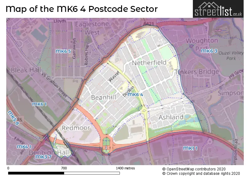
The largest settlement in the MK6 4 postal code is Netherfield followed by Beanhill, and Ashland.
The MK6 4 Postcode shares a border with MK3 7 (Bletchley), MK6 3 (Springfield, Peartree Bridge, Tinkers Bridge), MK1 1 (Bletchley, MILTON KEYNES), MK3 6 (Bletchley) and MK6 5 (Eaglestone, Coffee Hall, Leadenhall).
The sector is within the post town of MILTON KEYNES.
MK6 4 is a postcode sector within the MK6 postcode district which is within the MK Milton Keynes postcode area.
The Royal Mail delivery office for the MK6 4 postal sector is the Brinklow (mk) Postal Delivery Office.
The area of the MK6 4 postcode sector is 0.70 square miles which is 1.82 square kilometres or 449.03 square acres.
The MK6 4 postcode sector is crossed by the A5 Major A road.

Map of the MK6 4 Postcode Sector
Explore the MK6 4 postcode sector by using our free interactive map.
| M | K | 6 | - | 4 | X | X |
| M | K | 6 | Space | 4 | Letter | Letter |
Official List of Streets
Netherfield (8 Streets)
Beanhill (17 Streets)
Redmoor (3 Streets)
Ashland (16 Streets)
Unofficial Streets or Alternative Spellings
Tinkers Bridge
PASSMOREBletchley
SAXON STREET WHADDON WAYBleak Hall
GRAFTON STREETEaglestone
STANDING WAYElfield Park
WATLING STREETWeather Forecast for MK6 4
Press Button to Show Forecast for Woughton On The Green
| Time Period | Icon | Description | Temperature | Rain Probability | Wind |
|---|---|---|---|---|---|
| 12:00 to 15:00 | Cloudy | 9.0°C (feels like 7.0°C) | 35.00% | WNW 9 mph | |
| 15:00 to 18:00 | Cloudy | 8.0°C (feels like 6.0°C) | 16.00% | NNW 11 mph | |
| 18:00 to 21:00 | Cloudy | 7.0°C (feels like 5.0°C) | 6.00% | NE 7 mph | |
| 21:00 to 00:00 | Cloudy | 5.0°C (feels like 4.0°C) | 4.00% | ENE 4 mph |
Press Button to Show Forecast for Woughton On The Green
| Time Period | Icon | Description | Temperature | Rain Probability | Wind |
|---|---|---|---|---|---|
| 00:00 to 03:00 | Cloudy | 4.0°C (feels like 2.0°C) | 4.00% | ENE 4 mph | |
| 03:00 to 06:00 | Partly cloudy (night) | 2.0°C (feels like 0.0°C) | 1.00% | NE 4 mph | |
| 06:00 to 09:00 | Partly cloudy (day) | 3.0°C (feels like 0.0°C) | 1.00% | NE 4 mph | |
| 09:00 to 12:00 | Partly cloudy (day) | 7.0°C (feels like 5.0°C) | 2.00% | ENE 7 mph | |
| 12:00 to 15:00 | Cloudy | 10.0°C (feels like 8.0°C) | 10.00% | ENE 7 mph | |
| 15:00 to 18:00 | Overcast | 11.0°C (feels like 10.0°C) | 11.00% | NE 4 mph | |
| 18:00 to 21:00 | Overcast | 9.0°C (feels like 7.0°C) | 13.00% | ENE 7 mph | |
| 21:00 to 00:00 | Cloudy | 6.0°C (feels like 4.0°C) | 10.00% | ENE 7 mph |
Press Button to Show Forecast for Woughton On The Green
| Time Period | Icon | Description | Temperature | Rain Probability | Wind |
|---|---|---|---|---|---|
| 00:00 to 03:00 | Cloudy | 4.0°C (feels like 2.0°C) | 11.00% | ENE 4 mph | |
| 03:00 to 06:00 | Cloudy | 3.0°C (feels like 1.0°C) | 14.00% | ENE 7 mph | |
| 06:00 to 09:00 | Cloudy | 4.0°C (feels like 1.0°C) | 19.00% | NE 7 mph | |
| 09:00 to 12:00 | Overcast | 8.0°C (feels like 6.0°C) | 23.00% | ENE 9 mph | |
| 12:00 to 15:00 | Overcast | 11.0°C (feels like 8.0°C) | 20.00% | ENE 9 mph | |
| 15:00 to 18:00 | Overcast | 11.0°C (feels like 9.0°C) | 21.00% | ENE 11 mph | |
| 18:00 to 21:00 | Cloudy | 10.0°C (feels like 8.0°C) | 19.00% | NE 11 mph | |
| 21:00 to 00:00 | Heavy rain | 8.0°C (feels like 5.0°C) | 73.00% | NE 11 mph |
Press Button to Show Forecast for Woughton On The Green
| Time Period | Icon | Description | Temperature | Rain Probability | Wind |
|---|---|---|---|---|---|
| 00:00 to 03:00 | Heavy rain | 7.0°C (feels like 4.0°C) | 73.00% | NE 11 mph | |
| 03:00 to 06:00 | Heavy rain | 8.0°C (feels like 5.0°C) | 78.00% | NE 9 mph | |
| 06:00 to 09:00 | Heavy rain | 8.0°C (feels like 6.0°C) | 74.00% | ESE 7 mph | |
| 09:00 to 12:00 | Light rain | 10.0°C (feels like 8.0°C) | 50.00% | ESE 9 mph | |
| 12:00 to 15:00 | Light rain | 11.0°C (feels like 9.0°C) | 55.00% | SSE 9 mph | |
| 15:00 to 18:00 | Heavy rain shower (day) | 12.0°C (feels like 10.0°C) | 58.00% | W 11 mph | |
| 18:00 to 21:00 | Light rain shower (day) | 10.0°C (feels like 8.0°C) | 35.00% | WSW 9 mph | |
| 21:00 to 00:00 | Partly cloudy (night) | 8.0°C (feels like 7.0°C) | 6.00% | WSW 7 mph |
Schools and Places of Education Within the MK6 4 Postcode Sector
Moorland Primary School
Academy sponsor led
Maslin Drive, Milton Keynes, Buckinghamshire, MK6 4ND
Head: Mrs A Garner
Ofsted Rating: Requires improvement
Inspection: 2023-12-06 (141 days ago)
Website: Visit Moorland Primary School Website
Phone: 01908678888
Number of Pupils: 208
Moorlands Centre Nursery School
Local authority nursery school
Beanhill Local Centre, Milton Keynes, Buckinghamshire, MK6 4LP
Head: Mr W Brooks
Ofsted Rating: Good
Inspection: 2018-07-18 (2108 days ago)
Website: Visit Moorlands Centre Nursery School Website
Phone: 01908679819
Number of Pupils: 34
The Redway School
Community special school
Farmborough, Milton Keynes, Buckinghamshire, MK6 4HG
Head: Mrs Diane Walker
Ofsted Rating: Good
Inspection: 2023-06-21 (309 days ago)
Website: Visit The Redway School Website
Phone: 01908206400
Number of Pupils: 171
House Prices in the MK6 4 Postcode Sector
| Type of Property | 2018 Average | 2018 Sales | 2017 Average | 2017 Sales | 2016 Average | 2016 Sales | 2015 Average | 2015 Sales |
|---|---|---|---|---|---|---|---|---|
| Detached | £415,000 | 3 | £419,286 | 7 | £400,118 | 17 | £363,525 | 20 |
| Semi-Detached | £229,571 | 7 | £233,590 | 11 | £226,625 | 4 | £213,273 | 11 |
| Terraced | £192,893 | 14 | £191,363 | 30 | £183,590 | 46 | £170,094 | 36 |
| Flats | £100,250 | 8 | £118,636 | 11 | £119,497 | 19 | £111,278 | 9 |
Important Postcodes MK6 4 in the Postcode Sector
MK6 4AD is the postcode for Parcelforce Worldwide, Dunsby Road
MK6 4HA is the postcode for Langland Community School, Langland Road
MK6 4HG is the postcode for THE REDWAY SCHOOL, FARMBOROUGH, NETHERFIELD, The Redway School, Farmborough, and Redway School, Farmborough, Netherfield
MK6 4LP is the postcode for Moorlands Childrens Centre, Unit 6 Local Centre, Dodkin
MK6 4ND is the postcode for Moorland Infant School, Maslin Drive
MK6 4NE is the postcode for Ashfield Medical Centre, 1 Perrydown
MK6 4NP is the postcode for Netherfield Playzone, Langland Road
| The MK6 4 Sector is within these Local Authorities |
|
|---|---|
| The MK6 4 Sector is within these Counties |
|
| The MK6 4 Sector is within these Water Company Areas |
|