The Origins of Street Numbering and Road Classification
The genesis of road numbering can be traced back to the establishment of the Ministry of Transport in 1919. This ministry had the primary responsibility of allocating funds for the maintenance of principal roads, leading to the need for a system to identify these key thoroughfares. One prevailing idea was that any road connecting large towns should be considered a principal one.
In 1921, André Michelin, from the renowned tire company and map producer, penned a letter to Sir Geddes, the Minister of Transport. He proposed a road numbering system that was reminiscent of the French method, which assigned numbers to roads radiating out from Paris.
The outcome was a decision to categorize roads into three main classes:
- 1st Class roads, denoted by an "A" prefix.
- 2nd Class roads, labeled with a "B" prefix.
- 3rd Class roads, which would start with "C."
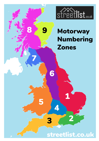
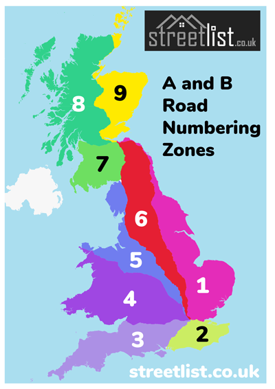
The numbering scheme divided Great Britain into nine distinct sectors. It started with the major roads emanating from London: the Great North Road was designated A1, while other significant roads branching out from the capital sequentially received the designations A2, A3, A4, A5, and A6 in a clockwise direction. Edinburgh, as another focal point, had the roads A7, A8, and A9 designated for the main arteries stemming from the Scottish capital.
These nine pivotal roads set the framework for the sectors still recognized in today's road numbering system:
- A1: London to Edinburgh
- A2: London to Dover
- A3: London to Portsmouth
- A4: London to Bath
- A5: London to Holyhead
- A6: London to Carlisle
- A7: Edinburgh to Carlisle
- A8: Edinburgh to Gourock
- A9: Edinburgh to Inverness
By 1925, these road numbers were prominently displayed on maps and road signs, embedding them into the public consciousness where they remain today.
In terms of visual representation, "A" roads were marked with black lettering against a white backdrop, while "B" roads featured white lettering on a black background. The "C" roads were designated with black lettering on a yellow background. However, this last classification didn't gain as much traction.