The N1 9 postcode sector is within the county of Greater London.
Did you know? According to the 2021 Census, the N1 9 postcode sector is home to a bustling 6,234 residents!
Given that each sector allows for 400 unique postcode combinations. Letters C, I, K, M, O and V are not allowed in the last two letters of a postcode. With 202 postcodes already in use, this leaves 198 units available.
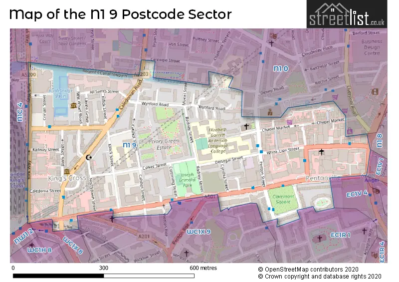
The N1 9 postal code covers the settlement of ISLINGTON .
The N1 9 Postcode shares a border with N1 0 (ISLINGTON ), N1 8 (ISLINGTON ), NW1 2 (LONDON ), N1C 4 (LONDON ), EC1V 7 (ISLINGTON ), EC1R 1 (ISLINGTON ), EC1V 1 (ISLINGTON , HACKNEY ), EC1V 4 (ISLINGTON ), WC1X 8 (LONDON ) and WC1X 9 (ISLINGTON , LONDON ).
The sector is within the post town of LONDON.
N1 9 is a postcode sector within the N1 postcode district which is within the N North London postcode area.
The Royal Mail delivery office for the N1 9 postal sector is the Islington Delivery Office.
The area of the N1 9 postcode sector is 0.17 square miles which is 0.45 square kilometres or 111.12 square acres.
Waterways within the N1 9 postcode sector include the Regent's Canal.

Map of the N1 9 Postcode Sector
Explore the N1 9 postcode sector by using our free interactive map.
| N | 1 | - | 9 | X | X |
| N | 1 | Space | 9 | Letter | Letter |
Official List of Streets
Islington (50 Streets)
Camden (1 Streets)
Unofficial Streets or Alternative Spellings
Islington
AMWELL STREET CALEDONIA STREET HOLFORD YARD LORENZO STREET PRIORY GREEN UPPER STREETCamden
EUSTON ROAD GOODS WAY GRAYS INN ROAD KINGS CROSS ROAD YORK WAYWeather Forecast for N1 9
Press Button to Show Forecast for St Pancras Youth Hostel
| Time Period | Icon | Description | Temperature | Rain Probability | Wind |
|---|---|---|---|---|---|
| 06:00 to 09:00 | Overcast | 6.0°C (feels like 6.0°C) | 18.00% | NW 2 mph | |
| 09:00 to 12:00 | Overcast | 7.0°C (feels like 6.0°C) | 19.00% | W 4 mph | |
| 12:00 to 15:00 | Overcast | 8.0°C (feels like 7.0°C) | 20.00% | NW 7 mph | |
| 15:00 to 18:00 | Light rain | 10.0°C (feels like 8.0°C) | 44.00% | NNW 9 mph | |
| 18:00 to 21:00 | Cloudy | 10.0°C (feels like 8.0°C) | 9.00% | NNE 9 mph | |
| 21:00 to 00:00 | Partly cloudy (night) | 8.0°C (feels like 6.0°C) | 1.00% | N 7 mph |
Press Button to Show Forecast for St Pancras Youth Hostel
| Time Period | Icon | Description | Temperature | Rain Probability | Wind |
|---|---|---|---|---|---|
| 00:00 to 03:00 | Partly cloudy (night) | 7.0°C (feels like 5.0°C) | 1.00% | NNW 7 mph | |
| 03:00 to 06:00 | Cloudy | 6.0°C (feels like 4.0°C) | 8.00% | NNW 7 mph | |
| 06:00 to 09:00 | Overcast | 6.0°C (feels like 3.0°C) | 8.00% | NNW 7 mph | |
| 09:00 to 12:00 | Overcast | 8.0°C (feels like 5.0°C) | 9.00% | NNW 9 mph | |
| 12:00 to 15:00 | Overcast | 9.0°C (feels like 7.0°C) | 9.00% | NNW 9 mph | |
| 15:00 to 18:00 | Cloudy | 10.0°C (feels like 8.0°C) | 7.00% | NNW 11 mph | |
| 18:00 to 21:00 | Cloudy | 9.0°C (feels like 7.0°C) | 6.00% | N 9 mph | |
| 21:00 to 00:00 | Partly cloudy (night) | 7.0°C (feels like 5.0°C) | 3.00% | N 7 mph |
Press Button to Show Forecast for St Pancras Youth Hostel
| Time Period | Icon | Description | Temperature | Rain Probability | Wind |
|---|---|---|---|---|---|
| 00:00 to 03:00 | Cloudy | 6.0°C (feels like 4.0°C) | 5.00% | N 7 mph | |
| 03:00 to 06:00 | Partly cloudy (night) | 5.0°C (feels like 3.0°C) | 2.00% | NW 7 mph | |
| 06:00 to 09:00 | Cloudy | 5.0°C (feels like 3.0°C) | 5.00% | NW 7 mph | |
| 09:00 to 12:00 | Cloudy | 8.0°C (feels like 6.0°C) | 5.00% | NNW 7 mph | |
| 12:00 to 15:00 | Overcast | 10.0°C (feels like 9.0°C) | 10.00% | NW 7 mph | |
| 15:00 to 18:00 | Overcast | 11.0°C (feels like 10.0°C) | 12.00% | NW 7 mph | |
| 18:00 to 21:00 | Cloudy | 11.0°C (feels like 9.0°C) | 11.00% | NNW 7 mph | |
| 21:00 to 00:00 | Cloudy | 9.0°C (feels like 8.0°C) | 8.00% | NNE 7 mph |
Press Button to Show Forecast for St Pancras Youth Hostel
| Time Period | Icon | Description | Temperature | Rain Probability | Wind |
|---|---|---|---|---|---|
| 00:00 to 03:00 | Partly cloudy (night) | 8.0°C (feels like 6.0°C) | 4.00% | ESE 4 mph | |
| 03:00 to 06:00 | Cloudy | 7.0°C (feels like 5.0°C) | 6.00% | W 4 mph | |
| 06:00 to 09:00 | Cloudy | 7.0°C (feels like 5.0°C) | 7.00% | ENE 4 mph | |
| 09:00 to 12:00 | Cloudy | 9.0°C (feels like 8.0°C) | 8.00% | E 7 mph | |
| 12:00 to 15:00 | Overcast | 11.0°C (feels like 10.0°C) | 13.00% | SSE 7 mph | |
| 15:00 to 18:00 | Overcast | 12.0°C (feels like 11.0°C) | 15.00% | W 7 mph | |
| 18:00 to 21:00 | Cloudy | 12.0°C (feels like 10.0°C) | 10.00% | S 7 mph | |
| 21:00 to 00:00 | Cloudy | 10.0°C (feels like 8.0°C) | 11.00% | SSE 7 mph |
Schools and Places of Education Within the N1 9 Postcode Sector
Elizabeth Garrett Anderson School
Community school
Donegal Street, London, , N1 9QG
Head: Ms Sarah Beagley
Ofsted Rating: Outstanding
Inspection: 2014-12-17 (3415 days ago)
Website: Visit Elizabeth Garrett Anderson School Website
Phone: 02078370739
Number of Pupils: 884
The Pears Family School
Free schools alternative provision
4-8 Rodney Street, London, , N1 9JH
Head: Mr Matthew Hillman
Ofsted Rating: Outstanding
Inspection: 2022-11-03 (537 days ago)
Website: Visit The Pears Family School Website
Phone: 02036934911
Number of Pupils: 2
Winton Primary School
Community school
Killick Street, London, , N1 9AZ
Head: Mr Tony McMahon
Ofsted Rating: Good
Inspection: 2023-03-14 (406 days ago)
Website: Visit Winton Primary School Website
Phone: 02078376096
Number of Pupils: 234
House Prices in the N1 9 Postcode Sector
| Type of Property | 2018 Average | 2018 Sales | 2017 Average | 2017 Sales | 2016 Average | 2016 Sales | 2015 Average | 2015 Sales |
|---|---|---|---|---|---|---|---|---|
| Detached | £1,725,000 | 1 | £0 | 0 | £0 | 0 | £0 | 0 |
| Semi-Detached | £0 | 0 | £0 | 0 | £0 | 0 | £0 | 0 |
| Terraced | £1,150,000 | 1 | £1,008,056 | 9 | £1,031,667 | 6 | £1,445,833 | 6 |
| Flats | £969,228 | 125 | £668,223 | 47 | £613,029 | 31 | £631,865 | 63 |
Important Postcodes N1 9 in the Postcode Sector
N1 9AZ is the postcode for Winton Primary School, Killick Street, and Winton Primary School, Killick Street, Islington
N1 9FL is the postcode for Bruce Kenrick House, 2 Killick Street
N1 9JD is the postcode for 1-5 Hermes Street, Islington
N1 9LZ is the postcode for National Association of Citizens Advice Bureaux, Myddleton House, 115-123 Pentonville Road
N1 9PF is the postcode for First and Second Floor, 74-77 White Lion Street, Islington
N1 9PU is the postcode for Public Carriage Office, 15 Penton Street, and Transport for London, 15 Penton Street
N1 9QG is the postcode for Elizabeth Garrett Anderson School, Donegal Street, and GARRETT ANDERSON BUILDING, Elizabeth Garrett Anderson School, Donegal Street
N1 9RH is the postcode for Killick Street Medical Centre, 75 Killick Street
N1 9XH is the postcode for Calshot Neighbourhood Office, 57 Calshot Street
| The N1 9 Sector is within these Local Authorities |
|
|---|---|
| The N1 9 Sector is within these Counties |
|
| The N1 9 Sector is within these Water Company Areas |
|