The N12 7 postcode sector is within the county of Greater London.
Did you know? According to the 2021 Census, the N12 7 postcode sector is home to a bustling 6,115 residents!
Given that each sector allows for 400 unique postcode combinations. Letters C, I, K, M, O and V are not allowed in the last two letters of a postcode. With 121 postcodes already in use, this leaves 279 units available.
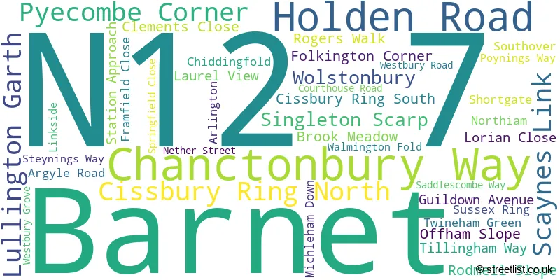
The largest settlement in the N12 7 postal code is NORTH FINCHLEY followed by WOODSIDE LANE TO WESTBURY ROAD , and SOUTHOVER TO ARLINGTON .
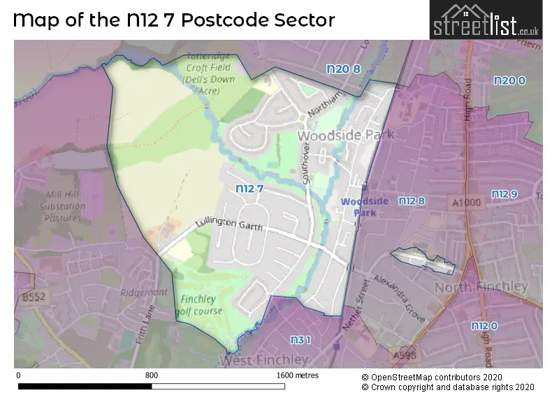
The N12 7 Postcode shares a border with N3 1 (FINCHLEY , REGENT CLOSE TO DOLLIS ROAD , CHURCH END ), N12 8 (NORTH FINCHLEY , REGENT CLOSE TO DOLLIS ROAD , FINCHLEY ), N20 0 (WHETSTONE , FRIERN BARNET , OAKLEIGH PARK ), NW7 1 (MILL HILL , CHURCH END ) and N20 8 (WHETSTONE , TOTTERIDGE ).
The sector is within the post town of LONDON.
N12 7 is a postcode sector within the N12 postcode district which is within the N North London postcode area.
The Royal Mail delivery office for the N12 7 postal sector is the North Finchley Sdelivery Office.
The area of the N12 7 postcode sector is 0.83 square miles which is 2.14 square kilometres or 528.29 square acres.
Waterways within the N12 7 postcode sector include the Folly Brook, Dollis Brook.

Map of the N12 7 Postcode Sector
Explore the N12 7 postcode sector by using our free interactive map.
| N | 1 | 2 | - | 7 | X | X |
| N | 1 | 2 | Space | 7 | Letter | Letter |
Official List of Streets
Barnet (40 Streets)
Unofficial Streets or Alternative Spellings
Weather Forecast for N12 7
Press Button to Show Forecast for Barnet
| Time Period | Icon | Description | Temperature | Rain Probability | Wind |
|---|---|---|---|---|---|
| 00:00 to 03:00 | Cloudy | 8.0°C (feels like 5.0°C) | 58.00% | WSW 13 mph | |
| 03:00 to 06:00 | Cloudy | 9.0°C (feels like 5.0°C) | 20.00% | W 13 mph | |
| 06:00 to 09:00 | Overcast | 9.0°C (feels like 6.0°C) | 53.00% | WNW 13 mph | |
| 09:00 to 12:00 | Cloudy | 10.0°C (feels like 7.0°C) | 32.00% | NW 18 mph | |
| 12:00 to 15:00 | Cloudy | 11.0°C (feels like 8.0°C) | 9.00% | NW 16 mph | |
| 15:00 to 18:00 | Cloudy | 11.0°C (feels like 8.0°C) | 48.00% | N 13 mph | |
| 18:00 to 21:00 | Cloudy | 8.0°C (feels like 6.0°C) | 38.00% | NNE 9 mph | |
| 21:00 to 00:00 | Cloudy | 7.0°C (feels like 4.0°C) | 5.00% | NNE 9 mph |
Press Button to Show Forecast for Barnet
| Time Period | Icon | Description | Temperature | Rain Probability | Wind |
|---|---|---|---|---|---|
| 00:00 to 03:00 | Clear night | 5.0°C (feels like 1.0°C) | 1.00% | N 11 mph | |
| 03:00 to 06:00 | Partly cloudy (night) | 4.0°C (feels like 0.0°C) | 2.00% | NNW 11 mph | |
| 06:00 to 09:00 | Cloudy | 4.0°C (feels like 0.0°C) | 5.00% | NNW 11 mph | |
| 09:00 to 12:00 | Overcast | 6.0°C (feels like 3.0°C) | 8.00% | N 13 mph | |
| 12:00 to 15:00 | Overcast | 8.0°C (feels like 5.0°C) | 9.00% | N 11 mph | |
| 15:00 to 18:00 | Overcast | 9.0°C (feels like 6.0°C) | 10.00% | N 11 mph | |
| 18:00 to 21:00 | Overcast | 8.0°C (feels like 6.0°C) | 9.00% | NNE 9 mph | |
| 21:00 to 00:00 | Partly cloudy (night) | 6.0°C (feels like 4.0°C) | 2.00% | NNE 7 mph |
Press Button to Show Forecast for Barnet
| Time Period | Icon | Description | Temperature | Rain Probability | Wind |
|---|---|---|---|---|---|
| 00:00 to 03:00 | Partly cloudy (night) | 5.0°C (feels like 2.0°C) | 2.00% | N 7 mph | |
| 03:00 to 06:00 | Cloudy | 4.0°C (feels like 2.0°C) | 4.00% | NNW 7 mph | |
| 06:00 to 09:00 | Cloudy | 4.0°C (feels like 2.0°C) | 6.00% | NNW 7 mph | |
| 09:00 to 12:00 | Overcast | 7.0°C (feels like 4.0°C) | 10.00% | N 9 mph | |
| 12:00 to 15:00 | Overcast | 9.0°C (feels like 6.0°C) | 12.00% | NNE 11 mph | |
| 15:00 to 18:00 | Cloudy | 10.0°C (feels like 7.0°C) | 7.00% | NNE 11 mph | |
| 18:00 to 21:00 | Cloudy | 9.0°C (feels like 6.0°C) | 6.00% | NNE 11 mph | |
| 21:00 to 00:00 | Clear night | 7.0°C (feels like 4.0°C) | 2.00% | NNE 11 mph |
Press Button to Show Forecast for Barnet
| Time Period | Icon | Description | Temperature | Rain Probability | Wind |
|---|---|---|---|---|---|
| 00:00 to 03:00 | Partly cloudy (night) | 5.0°C (feels like 2.0°C) | 4.00% | NNE 9 mph | |
| 03:00 to 06:00 | Clear night | 4.0°C (feels like 1.0°C) | 2.00% | NNE 9 mph | |
| 06:00 to 09:00 | Sunny day | 4.0°C (feels like 1.0°C) | 2.00% | N 9 mph | |
| 09:00 to 12:00 | Cloudy | 8.0°C (feels like 5.0°C) | 7.00% | NNE 11 mph | |
| 12:00 to 15:00 | Overcast | 10.0°C (feels like 7.0°C) | 12.00% | NNE 11 mph | |
| 15:00 to 18:00 | Cloudy | 10.0°C (feels like 7.0°C) | 10.00% | NNE 11 mph | |
| 18:00 to 21:00 | Cloudy | 9.0°C (feels like 6.0°C) | 7.00% | NE 11 mph | |
| 21:00 to 00:00 | Partly cloudy (night) | 7.0°C (feels like 4.0°C) | 3.00% | NNE 9 mph |
Schools and Places of Education Within the N12 7 Postcode Sector
Frith Manor Primary School
Community school
Lullington Garth, London, , N12 7BN
Head: Ms Wendy Wayland
Ofsted Rating: Good
Inspection: 2019-06-25 (1760 days ago)
Website: Visit Frith Manor Primary School Website
Phone: 02083462388
Number of Pupils: 521
St Michael's Catholic Grammar School
Voluntary aided school
Nether Street, London, , N12 7NJ
Head: Mr Michael Stimpson
Ofsted Rating: Outstanding
Inspection: 2022-11-10 (526 days ago)
Website: Visit St Michael's Catholic Grammar School Website
Phone: 02084462256
Number of Pupils: 849
Woodridge Primary School
Community school
Southover, London, , N12 7HE
Head: Mr Colin Dowland/ Ms Laura Monro
Ofsted Rating: Good
Inspection: 2019-10-17 (1646 days ago)
Website: Visit Woodridge Primary School Website
Phone: 02084455478
Number of Pupils: 203
House Prices in the N12 7 Postcode Sector
| Type of Property | 2018 Average | 2018 Sales | 2017 Average | 2017 Sales | 2016 Average | 2016 Sales | 2015 Average | 2015 Sales |
|---|---|---|---|---|---|---|---|---|
| Detached | £1,031,111 | 9 | £1,138,333 | 6 | £1,030,167 | 6 | £1,173,500 | 4 |
| Semi-Detached | £841,848 | 26 | £864,258 | 31 | £860,455 | 22 | £827,755 | 37 |
| Terraced | £791,786 | 7 | £675,000 | 6 | £572,500 | 5 | £722,389 | 9 |
| Flats | £583,512 | 14 | £452,118 | 17 | £448,038 | 26 | £418,338 | 17 |
Important Postcodes N12 7 in the Postcode Sector
N12 7BN is the postcode for Frith Manor Primary School, Lullington Garth
N12 7HE is the postcode for Woodridge Primary School, Southover
N12 7NJ is the postcode for Lower School, St Michaels Catholic Primary School, Nether St, SPORTS HALL, St. Michaels Grammar School, Nether Street, NEW BUILDING, ST MICHAELS CATHOLIC SCHOOL, Nether St, MAIN SCHOOL ST. MICHAEL'S GRAMMAR SCHOOL, St. Michaels Grammar School, Nether Street, and LOWER SCHOOL ST. MICHAEL'S GRAMMAR SCHOOL, St. Michaels Grammar School, Nether Street
| The N12 7 Sector is within these Local Authorities |
|
|---|---|
| The N12 7 Sector is within these Counties |
|
| The N12 7 Sector is within these Water Company Areas |
|