The N12 9 postcode sector is within the county of Greater London.
Did you know? According to the 2021 Census, the N12 9 postcode sector is home to a bustling 8,074 residents!
Given that each sector allows for 400 unique postcode combinations. Letters C, I, K, M, O and V are not allowed in the last two letters of a postcode. With 186 postcodes already in use, this leaves 214 units available.
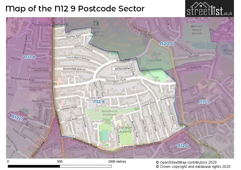
The N12 9 postal code covers the settlement of NORTH FINCHLEY .
The N12 9 Postcode shares a border with N11 3 (NEW SOUTHGATE , FRIERN BARNET , COLNEY HATCH ), N12 0 (NORTH FINCHLEY , COLNEY HATCH , FINCHLEY ), N12 8 (NORTH FINCHLEY , REGENT CLOSE TO DOLLIS ROAD , FINCHLEY ) and N20 0 (WHETSTONE , FRIERN BARNET , OAKLEIGH PARK ).
The sector is within the post town of LONDON.
N12 9 is a postcode sector within the N12 postcode district which is within the N North London postcode area.
The Royal Mail delivery office for the N12 9 postal sector is the North Finchley Sdelivery Office.
The area of the N12 9 postcode sector is 0.41 square miles which is 1.05 square kilometres or 259.53 square acres.

Map of the N12 9 Postcode Sector
Explore the N12 9 postcode sector by using our free interactive map.
| N | 1 | 2 | - | 9 | X | X |
| N | 1 | 2 | Space | 9 | Letter | Letter |
Official List of Streets
Barnet (48 Streets)
Unofficial Streets or Alternative Spellings
Weather Forecast for N12 9
Press Button to Show Forecast for Barnet
| Time Period | Icon | Description | Temperature | Rain Probability | Wind |
|---|---|---|---|---|---|
| 03:00 to 06:00 | Cloudy | 4.0°C (feels like 0.0°C) | 3.00% | NNW 9 mph | |
| 06:00 to 09:00 | Cloudy | 4.0°C (feels like 1.0°C) | 5.00% | NNW 9 mph | |
| 09:00 to 12:00 | Cloudy | 7.0°C (feels like 3.0°C) | 4.00% | NNW 11 mph | |
| 12:00 to 15:00 | Cloudy | 9.0°C (feels like 6.0°C) | 7.00% | NNW 11 mph | |
| 15:00 to 18:00 | Cloudy | 9.0°C (feels like 7.0°C) | 7.00% | N 11 mph | |
| 18:00 to 21:00 | Cloudy | 9.0°C (feels like 7.0°C) | 4.00% | N 7 mph | |
| 21:00 to 00:00 | Cloudy | 6.0°C (feels like 5.0°C) | 3.00% | NE 4 mph |
Press Button to Show Forecast for Barnet
| Time Period | Icon | Description | Temperature | Rain Probability | Wind |
|---|---|---|---|---|---|
| 00:00 to 03:00 | Cloudy | 5.0°C (feels like 3.0°C) | 4.00% | SW 4 mph | |
| 03:00 to 06:00 | Cloudy | 4.0°C (feels like 2.0°C) | 4.00% | WSW 7 mph | |
| 06:00 to 09:00 | Cloudy | 5.0°C (feels like 2.0°C) | 5.00% | W 9 mph | |
| 09:00 to 12:00 | Cloudy | 7.0°C (feels like 5.0°C) | 8.00% | W 9 mph | |
| 12:00 to 15:00 | Overcast | 9.0°C (feels like 7.0°C) | 15.00% | WNW 9 mph | |
| 15:00 to 18:00 | Overcast | 10.0°C (feels like 8.0°C) | 14.00% | WNW 9 mph | |
| 18:00 to 21:00 | Cloudy | 9.0°C (feels like 8.0°C) | 12.00% | NW 7 mph | |
| 21:00 to 00:00 | Cloudy | 7.0°C (feels like 5.0°C) | 8.00% | NNE 7 mph |
Press Button to Show Forecast for Barnet
| Time Period | Icon | Description | Temperature | Rain Probability | Wind |
|---|---|---|---|---|---|
| 00:00 to 03:00 | Cloudy | 5.0°C (feels like 3.0°C) | 5.00% | N 7 mph | |
| 03:00 to 06:00 | Cloudy | 4.0°C (feels like 2.0°C) | 5.00% | NE 7 mph | |
| 06:00 to 09:00 | Cloudy | 4.0°C (feels like 2.0°C) | 8.00% | ENE 7 mph | |
| 09:00 to 12:00 | Cloudy | 7.0°C (feels like 5.0°C) | 10.00% | ESE 7 mph | |
| 12:00 to 15:00 | Overcast | 10.0°C (feels like 8.0°C) | 16.00% | SE 7 mph | |
| 15:00 to 18:00 | Cloudy | 10.0°C (feels like 8.0°C) | 19.00% | ESE 9 mph | |
| 18:00 to 21:00 | Cloudy | 9.0°C (feels like 7.0°C) | 18.00% | ESE 9 mph | |
| 21:00 to 00:00 | Cloudy | 8.0°C (feels like 5.0°C) | 15.00% | ESE 9 mph |
Press Button to Show Forecast for Barnet
| Time Period | Icon | Description | Temperature | Rain Probability | Wind |
|---|---|---|---|---|---|
| 00:00 to 03:00 | Cloudy | 7.0°C (feels like 4.0°C) | 19.00% | ESE 9 mph | |
| 03:00 to 06:00 | Cloudy | 6.0°C (feels like 4.0°C) | 21.00% | E 9 mph | |
| 06:00 to 09:00 | Overcast | 7.0°C (feels like 4.0°C) | 22.00% | E 9 mph | |
| 09:00 to 12:00 | Cloudy | 9.0°C (feels like 7.0°C) | 18.00% | SE 9 mph | |
| 12:00 to 15:00 | Light rain shower (day) | 11.0°C (feels like 9.0°C) | 33.00% | ESE 9 mph | |
| 15:00 to 18:00 | Light rain | 12.0°C (feels like 10.0°C) | 50.00% | ESE 11 mph | |
| 18:00 to 21:00 | Light rain shower (day) | 11.0°C (feels like 9.0°C) | 34.00% | ESE 9 mph | |
| 21:00 to 00:00 | Cloudy | 10.0°C (feels like 8.0°C) | 17.00% | ESE 9 mph |
Schools and Places of Education Within the N12 9 Postcode Sector
Sacks Morasha Jewish Primary School
Academy converter
31 Stanhope Road, London, , N12 9DX
Head: Mrs Dena Shmuel
Ofsted Rating: Good
Inspection: 2023-07-13 (286 days ago)
Website: Visit Sacks Morasha Jewish Primary School Website
Phone: 02031151900
Number of Pupils: 207
Woodhouse College
Academy 16-19 converter
Woodhouse Road, London, , N12 9EY
Head: Ms Sugra Alibhai
Ofsted Rating: Outstanding
Inspection: 2022-05-27 (698 days ago)
Website: Visit Woodhouse College Website
Phone: 02084451210
Number of Pupils: 0
Woodside School
Other independent special school
25 Ravensdale Avenue, , , N12 9HP
Head: Headteacher Katerina Cahill
Ofsted Rating: Requires improvement
Inspection: 2022-06-30 (664 days ago)
Website: Visit Woodside School Website
Phone: 07956351971
Number of Pupils: 3
Wren Academy Finchley
Academy sponsor led
Hilton Avenue, London, , N12 9HB
Head: Mr John Keohane
Ofsted Rating: Outstanding
Inspection: 2018-09-19 (2044 days ago)
Website: Visit Wren Academy Finchley Website
Phone: 02084926000
Number of Pupils: 1626
House Prices in the N12 9 Postcode Sector
| Type of Property | 2018 Average | 2018 Sales | 2017 Average | 2017 Sales | 2016 Average | 2016 Sales | 2015 Average | 2015 Sales |
|---|---|---|---|---|---|---|---|---|
| Detached | £0 | 0 | £989,500 | 7 | £1,065,625 | 4 | £1,026,000 | 3 |
| Semi-Detached | £777,766 | 22 | £701,714 | 14 | £804,379 | 17 | £719,262 | 21 |
| Terraced | £676,500 | 19 | £673,988 | 16 | £693,382 | 17 | £650,604 | 23 |
| Flats | £313,259 | 46 | £324,584 | 61 | £319,228 | 53 | £290,082 | 54 |
Important Postcodes N12 9 in the Postcode Sector
N12 9DX is the postcode for SACKS MORASHA JEWISH PRIMARY SCHOOL, 31, Stanhope Road
N12 9EY is the postcode for Woodhouse Sixth Form College, Woodhouse Road, MILLENNIUM BUILDING, Woodhouse Sixth Form College, Woodhouse Road, WOODHOUSE MAIN BUILDING, Woodhouse Sixth Form College, Woodhouse Road, HOCKMAN BUILDING, Woodhouse Sixth Form College, Woodhouse Road, MATHS BLOCK, Woodhouse Sixth Form College, Woodhouse Road, and MAIN BUILDING, Woodhouse Sixth Form College, Woodhouse Road
N12 9HB is the postcode for C BLOCK, Wren Academy, 41 Hilton Avenue, D BLOCK, Wren Academy, 41 Hilton Avenue, F BLOCK, Wren Academy, 41 Hilton Avenue, B BLOCK, Wren Academy, 41 Hilton Avenue, A BLOCK & PRIMARY, Wren Academy, 41 Hilton Avenue, and E BLOCK, Wren Academy, 41 Hilton Avenue
N12 9HP is the postcode for London Borough of Barnet Council, North Finchley Library, Ravensdale Avenue
N12 9SS is the postcode for Torrington Park Health Centre, 16 Torrington Park, and The Health Centre, 16 Torrington Park, North Finchley
| The N12 9 Sector is within these Local Authorities |
|
|---|---|
| The N12 9 Sector is within these Counties |
|
| The N12 9 Sector is within these Water Company Areas |
|