The N14 5 postcode sector is within the county of Greater London.
Did you know? According to the 2021 Census, the N14 5 postcode sector is home to a bustling 6,628 residents!
Given that each sector allows for 400 unique postcode combinations. Letters C, I, K, M, O and V are not allowed in the last two letters of a postcode. With 160 postcodes already in use, this leaves 240 units available.
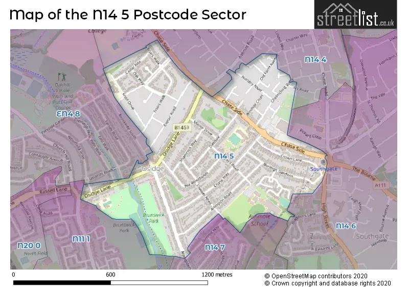
The largest settlements in the N14 5 postal code are SOUTHGATE and NEW SOUTHGATE .
The N14 5 Postcode shares a border with N11 1 (NEW SOUTHGATE , SOUTHGATE , BRUNSWICK PARK ), N14 6 (SOUTHGATE , NEW SOUTHGATE ), N14 7 (SOUTHGATE , WINCHMORE HILL , NEW SOUTHGATE ), N14 4 (SOUTHGATE , NEW SOUTHGATE ) and EN4 8 (EAST BARNET , NEW BARNET , STATION ROAD TO BROOKHILL ROAD ).
The sector is within the post town of LONDON.
N14 5 is a postcode sector within the N14 postcode district which is within the N North London postcode area.
The Royal Mail delivery office for the N14 5 postal sector is the Southgate Sdelivery Office.
The area of the N14 5 postcode sector is 0.44 square miles which is 1.14 square kilometres or 282.77 square acres.

Map of the N14 5 Postcode Sector
Explore the N14 5 postcode sector by using our free interactive map.
| N | 1 | 4 | - | 5 | X | X |
| N | 1 | 4 | Space | 5 | Letter | Letter |
Official List of Streets
Barnet (27 Streets)
Enfield (17 Streets)
Unofficial Streets or Alternative Spellings
Weather Forecast for N14 5
Press Button to Show Forecast for Wood Green
| Time Period | Icon | Description | Temperature | Rain Probability | Wind |
|---|---|---|---|---|---|
| 18:00 to 21:00 | Cloudy | 9.0°C (feels like 7.0°C) | 34.00% | N 7 mph | |
| 21:00 to 00:00 | Cloudy | 7.0°C (feels like 6.0°C) | 8.00% | ENE 7 mph |
Press Button to Show Forecast for Wood Green
| Time Period | Icon | Description | Temperature | Rain Probability | Wind |
|---|---|---|---|---|---|
| 00:00 to 03:00 | Cloudy | 6.0°C (feels like 4.0°C) | 5.00% | NE 7 mph | |
| 03:00 to 06:00 | Cloudy | 5.0°C (feels like 3.0°C) | 4.00% | NE 7 mph | |
| 06:00 to 09:00 | Cloudy | 5.0°C (feels like 2.0°C) | 4.00% | NE 7 mph | |
| 09:00 to 12:00 | Partly cloudy (day) | 8.0°C (feels like 6.0°C) | 2.00% | ENE 7 mph | |
| 12:00 to 15:00 | Cloudy | 11.0°C (feels like 9.0°C) | 9.00% | E 4 mph | |
| 15:00 to 18:00 | Overcast | 11.0°C (feels like 10.0°C) | 14.00% | ENE 7 mph | |
| 18:00 to 21:00 | Cloudy | 10.0°C (feels like 9.0°C) | 11.00% | E 7 mph | |
| 21:00 to 00:00 | Cloudy | 7.0°C (feels like 5.0°C) | 11.00% | E 7 mph |
Press Button to Show Forecast for Wood Green
| Time Period | Icon | Description | Temperature | Rain Probability | Wind |
|---|---|---|---|---|---|
| 00:00 to 03:00 | Cloudy | 5.0°C (feels like 3.0°C) | 12.00% | ENE 7 mph | |
| 03:00 to 06:00 | Cloudy | 5.0°C (feels like 3.0°C) | 18.00% | NE 7 mph | |
| 06:00 to 09:00 | Cloudy | 6.0°C (feels like 3.0°C) | 21.00% | NE 7 mph | |
| 09:00 to 12:00 | Overcast | 10.0°C (feels like 8.0°C) | 19.00% | ENE 9 mph | |
| 12:00 to 15:00 | Cloudy | 12.0°C (feels like 10.0°C) | 18.00% | E 9 mph | |
| 15:00 to 18:00 | Light rain | 12.0°C (feels like 10.0°C) | 52.00% | E 11 mph | |
| 18:00 to 21:00 | Light rain | 11.0°C (feels like 9.0°C) | 53.00% | ENE 9 mph | |
| 21:00 to 00:00 | Light rain | 10.0°C (feels like 7.0°C) | 50.00% | ENE 11 mph |
Press Button to Show Forecast for Wood Green
| Time Period | Icon | Description | Temperature | Rain Probability | Wind |
|---|---|---|---|---|---|
| 00:00 to 03:00 | Light rain | 9.0°C (feels like 7.0°C) | 54.00% | NE 9 mph | |
| 03:00 to 06:00 | Light rain | 10.0°C (feels like 8.0°C) | 56.00% | ESE 9 mph | |
| 06:00 to 09:00 | Overcast | 10.0°C (feels like 8.0°C) | 51.00% | SE 7 mph | |
| 09:00 to 12:00 | Light rain shower (day) | 11.0°C (feels like 9.0°C) | 45.00% | SE 9 mph | |
| 12:00 to 15:00 | Heavy rain shower (day) | 13.0°C (feels like 11.0°C) | 61.00% | SSW 9 mph | |
| 15:00 to 18:00 | Light rain shower (day) | 14.0°C (feels like 12.0°C) | 42.00% | SW 11 mph | |
| 18:00 to 21:00 | Cloudy | 12.0°C (feels like 10.0°C) | 17.00% | SW 11 mph | |
| 21:00 to 00:00 | Cloudy | 10.0°C (feels like 9.0°C) | 8.00% | SW 7 mph |
Schools and Places of Education Within the N14 5 Postcode Sector
Ashmole Academy
Academy converter
Cecil Road, London, , N14 5RJ
Head: Mr Balbinder Dhinsa
Ofsted Rating: Good
Inspection: 2021-12-01 (876 days ago)
Website: Visit Ashmole Academy Website
Phone: 02083612703
Number of Pupils: 1893
Brunswick Park Primary and Nursery School
Community school
Osidge Lane, London, , N14 5DU
Head: Mr Andy Griffiths
Ofsted Rating: Good
Inspection: 2023-03-22 (400 days ago)
Website: Visit Brunswick Park Primary and Nursery School Website
Phone: 02083683468
Number of Pupils: 457
Hampden Way Nursery School
Local authority nursery school
Hampden Way, London, , N14 5DJ
Head: Mrs Kelly Brooker
Ofsted Rating: Outstanding
Inspection: 2023-01-26 (455 days ago)
Website: Visit Hampden Way Nursery School Website
Phone: 02084495466
Number of Pupils: 103
Monkfrith Primary School
Community school
Knoll Drive, London, , N14 5NG
Head: Ms Jude Deasey
Ofsted Rating: Good
Inspection: 2023-10-18 (190 days ago)
Website: Visit Monkfrith Primary School Website
Phone: 02083686020
Number of Pupils: 420
Osidge Primary School
Foundation school
Chase Side, London, , N14 5HD
Head: Ms Jennifer Brodkin
Ofsted Rating: Good
Inspection: 2018-06-13 (2143 days ago)
Website: Visit Osidge Primary School Website
Phone: 02088867108
Number of Pupils: 415
House Prices in the N14 5 Postcode Sector
| Type of Property | 2018 Average | 2018 Sales | 2017 Average | 2017 Sales | 2016 Average | 2016 Sales | 2015 Average | 2015 Sales |
|---|---|---|---|---|---|---|---|---|
| Detached | £780,000 | 3 | £852,000 | 5 | £866,429 | 7 | £847,222 | 9 |
| Semi-Detached | £658,281 | 16 | £708,929 | 21 | £737,664 | 19 | £629,982 | 28 |
| Terraced | £595,708 | 12 | £552,576 | 19 | £569,759 | 14 | £442,727 | 11 |
| Flats | £334,910 | 10 | £345,500 | 11 | £280,823 | 18 | £326,208 | 22 |
Important Postcodes N14 5 in the Postcode Sector
N14 5BW is the postcode for Southgate Police Station, 25 Chase Side, and Metropolitan Police, Southgate Police Station, 25 Chase Side
N14 5DU is the postcode for 2 STOREY CLASSROOM BLOCK, Brunswick Park School, Osidge Lane, and Brunswick Park Primary & Nursery School, Osidge Lane
N14 5HD is the postcode for Osidge Primary School, Chase Side
N14 5NG is the postcode for Monkfrith Primary School, Knoll Drive
N14 5RJ is the postcode for Main Building, Ashmole Academy, Cecil Road, PERFORMING ARTS BLOCK, Ashmole School, Cecil Road, Technology Block, Ashmole Academy, Cecil Road, TECHNOLOGY BLOCK, Ashmole School, Cecil Road, ASHMOLE ACADEMY, CECIL ROAD, SOUTHGATE, Ashmole School, Cecil Road, and 6TH FORM CENTRE, Ashmole School, Cecil Road
| The N14 5 Sector is within these Local Authorities |
|
|---|---|
| The N14 5 Sector is within these Counties |
|
| The N14 5 Sector is within these Water Company Areas |
|