The N14 7 postcode sector is within the county of Greater London.
Did you know? According to the 2021 Census, the N14 7 postcode sector is home to a bustling 6,249 residents!
Given that each sector allows for 400 unique postcode combinations. Letters C, I, K, M, O and V are not allowed in the last two letters of a postcode. With 117 postcodes already in use, this leaves 283 units available.
The largest settlement in the N14 7 postal code is SOUTHGATE followed by WINCHMORE HILL , and NEW SOUTHGATE .
The N14 7 Postcode shares a border with N11 1 (NEW SOUTHGATE , SOUTHGATE , BRUNSWICK PARK ), N14 5 (SOUTHGATE , NEW SOUTHGATE ), N14 6 (SOUTHGATE , NEW SOUTHGATE ), N13 4 (SOUTHGATE ) and N11 2 (WOOD GREEN , SOUTHGATE , NEW SOUTHGATE ).
The sector is within the post town of LONDON.
N14 7 is a postcode sector within the N14 postcode district which is within the N North London postcode area.
The Royal Mail delivery office for the N14 7 postal sector is the Southgate Sdelivery Office.
The area of the N14 7 postcode sector is 0.52 square miles which is 1.34 square kilometres or 331.58 square acres.

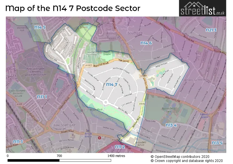
Map of the N14 7 Postcode Sector
Explore the N14 7 postcode sector by using our free interactive map.
| N | 1 | 4 | - | 7 | X | X |
| N | 1 | 4 | Space | 7 | Letter | Letter |
Official List of Streets
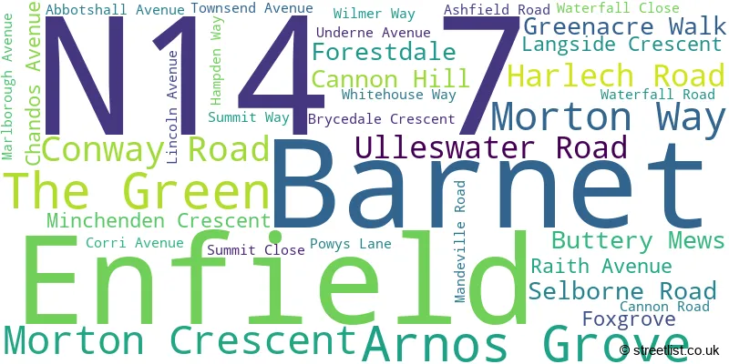
Enfield (26 Streets)
Barnet (10 Streets)
Unofficial Streets or Alternative Spellings
Weather Forecast for N14 7
Press Button to Show Forecast for Wood Green
| Time Period | Icon | Description | Temperature | Rain Probability | Wind |
|---|---|---|---|---|---|
| 03:00 to 06:00 | Cloudy | 7.0°C (feels like 5.0°C) | 6.00% | SSW 7 mph | |
| 06:00 to 09:00 | Cloudy | 7.0°C (feels like 5.0°C) | 7.00% | SW 7 mph | |
| 09:00 to 12:00 | Cloudy | 9.0°C (feels like 8.0°C) | 10.00% | W 7 mph | |
| 12:00 to 15:00 | Cloudy | 11.0°C (feels like 8.0°C) | 14.00% | W 9 mph | |
| 15:00 to 18:00 | Light rain shower (day) | 11.0°C (feels like 9.0°C) | 49.00% | WNW 9 mph | |
| 18:00 to 21:00 | Cloudy | 9.0°C (feels like 7.0°C) | 34.00% | N 7 mph | |
| 21:00 to 00:00 | Cloudy | 7.0°C (feels like 6.0°C) | 8.00% | ENE 7 mph |
Press Button to Show Forecast for Wood Green
| Time Period | Icon | Description | Temperature | Rain Probability | Wind |
|---|---|---|---|---|---|
| 00:00 to 03:00 | Cloudy | 6.0°C (feels like 4.0°C) | 5.00% | NE 7 mph | |
| 03:00 to 06:00 | Cloudy | 5.0°C (feels like 3.0°C) | 4.00% | NE 7 mph | |
| 06:00 to 09:00 | Cloudy | 5.0°C (feels like 2.0°C) | 4.00% | NE 7 mph | |
| 09:00 to 12:00 | Partly cloudy (day) | 8.0°C (feels like 6.0°C) | 2.00% | ENE 7 mph | |
| 12:00 to 15:00 | Cloudy | 11.0°C (feels like 9.0°C) | 9.00% | E 4 mph | |
| 15:00 to 18:00 | Overcast | 11.0°C (feels like 10.0°C) | 14.00% | ENE 7 mph | |
| 18:00 to 21:00 | Cloudy | 10.0°C (feels like 9.0°C) | 11.00% | E 7 mph | |
| 21:00 to 00:00 | Cloudy | 7.0°C (feels like 5.0°C) | 11.00% | E 7 mph |
Press Button to Show Forecast for Wood Green
| Time Period | Icon | Description | Temperature | Rain Probability | Wind |
|---|---|---|---|---|---|
| 00:00 to 03:00 | Cloudy | 5.0°C (feels like 3.0°C) | 12.00% | ENE 7 mph | |
| 03:00 to 06:00 | Cloudy | 5.0°C (feels like 3.0°C) | 18.00% | NE 7 mph | |
| 06:00 to 09:00 | Cloudy | 6.0°C (feels like 3.0°C) | 21.00% | NE 7 mph | |
| 09:00 to 12:00 | Overcast | 10.0°C (feels like 8.0°C) | 19.00% | ENE 9 mph | |
| 12:00 to 15:00 | Cloudy | 12.0°C (feels like 10.0°C) | 18.00% | E 9 mph | |
| 15:00 to 18:00 | Light rain | 12.0°C (feels like 10.0°C) | 52.00% | E 11 mph | |
| 18:00 to 21:00 | Light rain | 11.0°C (feels like 9.0°C) | 53.00% | ENE 9 mph | |
| 21:00 to 00:00 | Light rain | 10.0°C (feels like 7.0°C) | 50.00% | ENE 11 mph |
Press Button to Show Forecast for Wood Green
| Time Period | Icon | Description | Temperature | Rain Probability | Wind |
|---|---|---|---|---|---|
| 00:00 to 03:00 | Light rain | 9.0°C (feels like 7.0°C) | 54.00% | NE 9 mph | |
| 03:00 to 06:00 | Light rain | 10.0°C (feels like 8.0°C) | 56.00% | ESE 9 mph | |
| 06:00 to 09:00 | Overcast | 10.0°C (feels like 8.0°C) | 51.00% | SE 7 mph | |
| 09:00 to 12:00 | Light rain shower (day) | 11.0°C (feels like 9.0°C) | 45.00% | SE 9 mph | |
| 12:00 to 15:00 | Heavy rain shower (day) | 13.0°C (feels like 11.0°C) | 61.00% | SSW 9 mph | |
| 15:00 to 18:00 | Light rain shower (day) | 14.0°C (feels like 12.0°C) | 42.00% | SW 11 mph | |
| 18:00 to 21:00 | Cloudy | 12.0°C (feels like 10.0°C) | 17.00% | SW 11 mph | |
| 21:00 to 00:00 | Cloudy | 10.0°C (feels like 9.0°C) | 8.00% | SW 7 mph |
Schools and Places of Education Within the N14 7 Postcode Sector
Ashmole Primary School
Free schools
Summit Way, London, , N14 7NP
Head: Mr Christopher Tofallis
Ofsted Rating: Outstanding
Inspection: 2019-05-09 (1813 days ago)
Website: Visit Ashmole Primary School Website
Phone: 02083611881
Number of Pupils: 422
Laurel Park School
Foundation school
Wilmer Way, London, , N14 7HY
Head: Ms Adele Christofi
Ofsted Rating: Requires improvement
Inspection: 2021-12-09 (868 days ago)
Website: Visit Laurel Park School Website
Phone: 02083684710
Number of Pupils: 677
St Monica's RC Primary School
Voluntary aided school
Cannon Road, London, , N14 7HE
Head: Mrs Kate Baptiste
Ofsted Rating: Good
Inspection: 2019-06-04 (1787 days ago)
Website: Visit St Monica's RC Primary School Website
Phone: 02088864647
Number of Pupils: 416
Walker Primary School
Academy converter
Waterfall Road, London, , N14 7EG
Head: Raakhee Tailor
Ofsted Rating: Good
Inspection: 2023-05-24 (337 days ago)
Website: Visit Walker Primary School Website
Phone: 02088863904
Number of Pupils: 421
House Prices in the N14 7 Postcode Sector
| Type of Property | 2018 Average | 2018 Sales | 2017 Average | 2017 Sales | 2016 Average | 2016 Sales | 2015 Average | 2015 Sales |
|---|---|---|---|---|---|---|---|---|
| Detached | £1,001,667 | 6 | £875,000 | 1 | £1,180,000 | 4 | £812,333 | 3 |
| Semi-Detached | £766,574 | 34 | £801,321 | 39 | £723,286 | 33 | £688,213 | 48 |
| Terraced | £849,167 | 6 | £782,333 | 6 | £0 | 0 | £727,999 | 5 |
| Flats | £366,000 | 13 | £452,845 | 8 | £381,136 | 11 | £332,018 | 11 |
Important Postcodes N14 7 in the Postcode Sector
N14 7EG is the postcode for Walker Primary School, The Green
N14 7HE is the postcode for St. Monicas RC Primary School, Cannon Road, and St. Monicas Catholic Primary School, Cannon Road
N14 7HY is the postcode for Broomfield School, 56 Wilmer Way, and Broomfield Secondary School, Wilmer Way
N14 7NP is the postcode for Ashmole Primary School, Summit Way
| The N14 7 Sector is within these Local Authorities |
|
|---|---|
| The N14 7 Sector is within these Counties |
|
| The N14 7 Sector is within these Water Company Areas |
|