The N15 5 postcode sector is within the county of Greater London.
Did you know? According to the 2021 Census, the N15 5 postcode sector is home to a bustling 9,945 residents!
Given that each sector allows for 400 unique postcode combinations. Letters C, I, K, M, O and V are not allowed in the last two letters of a postcode. With 158 postcodes already in use, this leaves 242 units available.
The N15 5 postal code covers the settlement of TOTTENHAM .
The N15 5 Postcode shares a border with N4 1 (TOTTENHAM , HORNSEY , HACKNEY ), N15 3 (TOTTENHAM ), N15 4 (TOTTENHAM ) and N15 6 (TOTTENHAM ).
The sector is within the post town of LONDON.
N15 5 is a postcode sector within the N15 postcode district which is within the N North London postcode area.
The Royal Mail delivery office for the N15 5 postal sector is the South Tottenham Sdelivery Office.
The area of the N15 5 postcode sector is 0.30 square miles which is 0.77 square kilometres or 190.92 square acres.

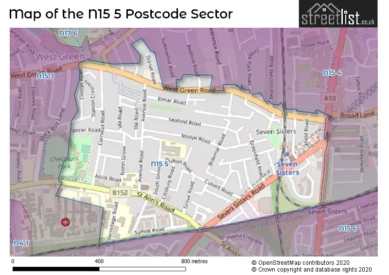
Map of the N15 5 Postcode Sector
Explore the N15 5 postcode sector by using our free interactive map.
| N | 1 | 5 | - | 5 | X | X |
| N | 1 | 5 | Space | 5 | Letter | Letter |
Official List of Streets
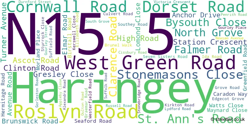
Haringey (59 Streets)
Unofficial Streets or Alternative Spellings
Weather Forecast for N15 5
Press Button to Show Forecast for Harringay
| Time Period | Icon | Description | Temperature | Rain Probability | Wind |
|---|---|---|---|---|---|
| 00:00 to 03:00 | Clear night | 6.0°C (feels like 3.0°C) | 0.00% | NNW 9 mph | |
| 03:00 to 06:00 | Partly cloudy (night) | 5.0°C (feels like 2.0°C) | 0.00% | NNW 9 mph | |
| 06:00 to 09:00 | Partly cloudy (day) | 5.0°C (feels like 2.0°C) | 1.00% | NNW 9 mph | |
| 09:00 to 12:00 | Cloudy | 8.0°C (feels like 5.0°C) | 4.00% | N 11 mph | |
| 12:00 to 15:00 | Cloudy | 11.0°C (feels like 8.0°C) | 4.00% | N 11 mph | |
| 15:00 to 18:00 | Cloudy | 11.0°C (feels like 9.0°C) | 7.00% | N 11 mph | |
| 18:00 to 21:00 | Cloudy | 10.0°C (feels like 8.0°C) | 3.00% | NNE 9 mph | |
| 21:00 to 00:00 | Cloudy | 8.0°C (feels like 6.0°C) | 5.00% | NNE 7 mph |
Press Button to Show Forecast for Harringay
| Time Period | Icon | Description | Temperature | Rain Probability | Wind |
|---|---|---|---|---|---|
| 00:00 to 03:00 | Cloudy | 6.0°C (feels like 5.0°C) | 6.00% | N 4 mph | |
| 03:00 to 06:00 | Partly cloudy (night) | 5.0°C (feels like 3.0°C) | 1.00% | N 7 mph | |
| 06:00 to 09:00 | Cloudy | 5.0°C (feels like 3.0°C) | 6.00% | N 7 mph | |
| 09:00 to 12:00 | Overcast | 8.0°C (feels like 5.0°C) | 8.00% | NNE 11 mph | |
| 12:00 to 15:00 | Overcast | 10.0°C (feels like 8.0°C) | 8.00% | NNE 11 mph | |
| 15:00 to 18:00 | Cloudy | 11.0°C (feels like 9.0°C) | 6.00% | NNE 11 mph | |
| 18:00 to 21:00 | Partly cloudy (day) | 10.0°C (feels like 8.0°C) | 2.00% | NNE 11 mph | |
| 21:00 to 00:00 | Clear night | 7.0°C (feels like 5.0°C) | 1.00% | NNE 9 mph |
Press Button to Show Forecast for Harringay
| Time Period | Icon | Description | Temperature | Rain Probability | Wind |
|---|---|---|---|---|---|
| 00:00 to 03:00 | Clear night | 6.0°C (feels like 3.0°C) | 2.00% | NNE 7 mph | |
| 03:00 to 06:00 | Clear night | 5.0°C (feels like 2.0°C) | 2.00% | N 7 mph | |
| 06:00 to 09:00 | Sunny day | 5.0°C (feels like 2.0°C) | 3.00% | N 7 mph | |
| 09:00 to 12:00 | Cloudy | 8.0°C (feels like 7.0°C) | 7.00% | N 7 mph | |
| 12:00 to 15:00 | Overcast | 10.0°C (feels like 9.0°C) | 13.00% | N 7 mph | |
| 15:00 to 18:00 | Overcast | 10.0°C (feels like 9.0°C) | 15.00% | NNW 7 mph | |
| 18:00 to 21:00 | Cloudy | 9.0°C (feels like 7.0°C) | 13.00% | NNW 7 mph | |
| 21:00 to 00:00 | Light rain | 8.0°C (feels like 6.0°C) | 49.00% | NNW 4 mph |
Press Button to Show Forecast for Harringay
| Time Period | Icon | Description | Temperature | Rain Probability | Wind |
|---|---|---|---|---|---|
| 00:00 to 03:00 | Light rain shower (night) | 6.0°C (feels like 5.0°C) | 36.00% | ENE 4 mph | |
| 03:00 to 06:00 | Cloudy | 6.0°C (feels like 4.0°C) | 10.00% | NNW 4 mph | |
| 06:00 to 09:00 | Cloudy | 6.0°C (feels like 4.0°C) | 11.00% | N 4 mph | |
| 09:00 to 12:00 | Overcast | 9.0°C (feels like 7.0°C) | 17.00% | NNE 7 mph | |
| 12:00 to 15:00 | Overcast | 10.0°C (feels like 9.0°C) | 19.00% | NNE 9 mph | |
| 15:00 to 18:00 | Overcast | 11.0°C (feels like 9.0°C) | 20.00% | NNE 9 mph | |
| 18:00 to 21:00 | Cloudy | 11.0°C (feels like 9.0°C) | 13.00% | NNE 9 mph | |
| 21:00 to 00:00 | Partly cloudy (night) | 8.0°C (feels like 7.0°C) | 10.00% | NNE 7 mph |
Schools and Places of Education Within the N15 5 Postcode Sector
Seven Sisters Primary School
Community school
South Grove, London, , N15 5QE
Head: Mrs Emma Murray
Ofsted Rating: Good
Inspection: 2019-03-26 (1852 days ago)
Website: Visit Seven Sisters Primary School Website
Phone: 02088026670
Number of Pupils: 260
St Ann's CE Primary School
Academy converter
Avenue Road, London, , N15 5JG
Head: Mr Simon Knowles
Ofsted Rating: Good
Inspection: 2023-11-08 (164 days ago)
Website: Visit St Ann's CE Primary School Website
Phone: 02088002781
Number of Pupils: 212
St Mary's Priory RC Infant School
Voluntary aided school
Hermitage Road, London, , N15 5RE
Head: Mrs Jane RONAN
Ofsted Rating: Good
Inspection: 2018-11-06 (1992 days ago)
Website: Visit St Mary's Priory RC Infant School Website
Phone: 02088009305
Number of Pupils: 136
St Mary's Priory RC Junior School
Voluntary aided school
Hermitage Road, LONDON, , N15 5RE
Head: Mrs Jane RONAN
Ofsted Rating: Good
Inspection: 2018-09-12 (2047 days ago)
Website: Visit St Mary's Priory RC Junior School Website
Phone: 02088009305
Number of Pupils: 171
House Prices in the N15 5 Postcode Sector
| Type of Property | 2018 Average | 2018 Sales | 2017 Average | 2017 Sales | 2016 Average | 2016 Sales | 2015 Average | 2015 Sales |
|---|---|---|---|---|---|---|---|---|
| Detached | £0 | 0 | £0 | 0 | £0 | 0 | £0 | 0 |
| Semi-Detached | £685,500 | 2 | £425,000 | 1 | £566,000 | 1 | £0 | 0 |
| Terraced | £515,198 | 39 | £530,509 | 34 | £481,395 | 38 | £433,110 | 62 |
| Flats | £343,500 | 22 | £334,583 | 32 | £307,048 | 35 | £299,799 | 37 |
Important Postcodes N15 5 in the Postcode Sector
N15 5AZ is the postcode for Laurels Healthy Living Centre, 256 St. Ann's Road
N15 5JG is the postcode for St. Ann's CE Primary School, Avenue Road
N15 5PQ is the postcode for London Borough of Haringey, Apex House, 820 Seven Sisters Road
N15 5PU is the postcode for Haringey Council, St. Anns Public Library, Cissbury Road
N15 5QE is the postcode for Seven Sisters Primary School, South Grove
N15 5RD is the postcode for Metropolitan Police, St. Ann's Road Police Station, 289 St. Ann's Road
N15 5RE is the postcode for St Mary's RC Infant/Junior School, Hermitage Road, St. Mary's Infant School, Hermitage Road, Junior School, St Mary's Priory RC Infant & Junior School, Hermitage Road, Infant School, St Mary's Priory RC Infant & Junior School, Hermitage Road, and St. Marys RC Junior School, Hermitage Road
| The N15 5 Sector is within these Local Authorities |
|
|---|---|
| The N15 5 Sector is within these Counties |
|
| The N15 5 Sector is within these Water Company Areas |
|