The N19 4 postcode sector is within the county of Greater London.
Did you know? According to the 2021 Census, the N19 4 postcode sector is home to a bustling 9,920 residents!
Given that each sector allows for 400 unique postcode combinations. Letters C, I, K, M, O and V are not allowed in the last two letters of a postcode. With 178 postcodes already in use, this leaves 222 units available.
The N19 4 postal code covers the settlement of ISLINGTON .
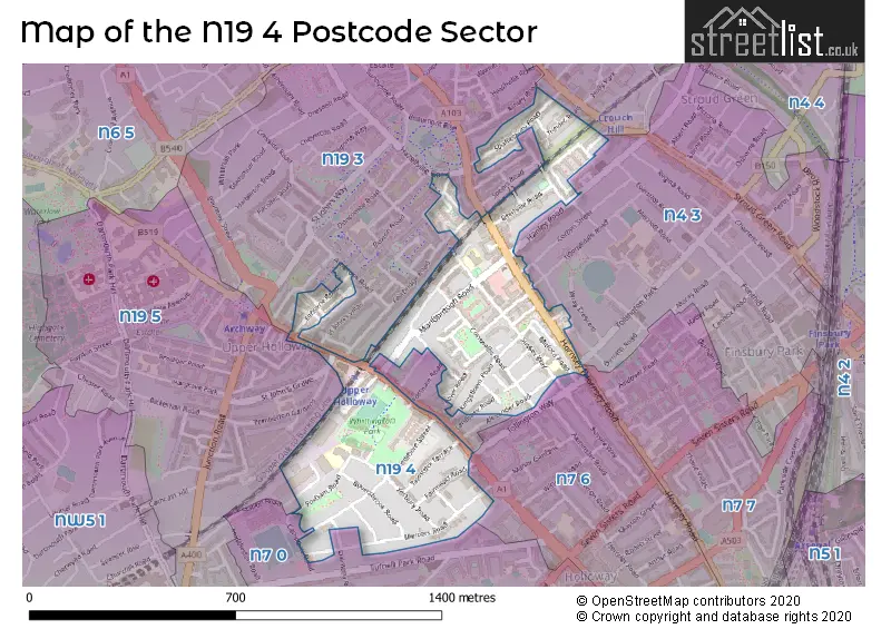
The N19 4 Postcode shares a border with N4 3 (ISLINGTON , HORNSEY ), N7 0 (ISLINGTON , LONDON ), N7 6 (ISLINGTON ), N19 5 (ISLINGTON , LONDON ), N19 3 (ISLINGTON ), N4 4 (HORNSEY , ISLINGTON ) and N7 7 (ISLINGTON ).
The sector is within the post town of LONDON.
N19 4 is a postcode sector within the N19 postcode district which is within the N North London postcode area.
The Royal Mail delivery office for the N19 4 postal sector is the Upper Holloway Sdelivery Office.
The area of the N19 4 postcode sector is 0.27 square miles which is 0.70 square kilometres or 173.38 square acres.


Map of the N19 4 Postcode Sector
Explore the N19 4 postcode sector by using our free interactive map.
| N | 1 | 9 | - | 4 | X | X |
| N | 1 | 9 | Space | 4 | Letter | Letter |
Official List of Streets
Islington (55 Streets)
Unofficial Streets or Alternative Spellings
Islington
ALMINGTON STREET ASHBROOK ROAD BEACHCROFT WAY CAMPDALE ROAD CHARLES STREET CORBYN STREET DALMENY ROAD DAVENANT ROAD FAIRBRIDGE ROAD FORTNAM ROAD HANLEY ROAD HARGRAVE ROAD HAZELLVILLE ROAD NUGENT ROAD PEMBERTON GARDENS PINE GROVE RUPERT ROAD STATION ROAD THORPEDALE ROAD TOLLINGTON PARK TOLLINGTON WAY TURPIN WAY BLENHEIM COURT COACHYARD MEWS HAMPDEN ROAD PEGASUS COURT ST JOHNS GROVE ST JOHNS VILLAS SUSSEX CLOSEWeather Forecast for N19 4
Press Button to Show Forecast for Arsenal F.C.
| Time Period | Icon | Description | Temperature | Rain Probability | Wind |
|---|---|---|---|---|---|
| 00:00 to 03:00 | Clear night | 6.0°C (feels like 3.0°C) | 0.00% | NNW 9 mph | |
| 03:00 to 06:00 | Clear night | 5.0°C (feels like 2.0°C) | 0.00% | NNW 9 mph | |
| 06:00 to 09:00 | Partly cloudy (day) | 5.0°C (feels like 2.0°C) | 1.00% | NNW 9 mph | |
| 09:00 to 12:00 | Cloudy | 8.0°C (feels like 5.0°C) | 4.00% | N 11 mph | |
| 12:00 to 15:00 | Cloudy | 10.0°C (feels like 8.0°C) | 4.00% | N 11 mph | |
| 15:00 to 18:00 | Cloudy | 11.0°C (feels like 9.0°C) | 4.00% | N 11 mph | |
| 18:00 to 21:00 | Cloudy | 10.0°C (feels like 8.0°C) | 3.00% | NNE 9 mph | |
| 21:00 to 00:00 | Cloudy | 8.0°C (feels like 6.0°C) | 5.00% | NNE 7 mph |
Press Button to Show Forecast for Arsenal F.C.
| Time Period | Icon | Description | Temperature | Rain Probability | Wind |
|---|---|---|---|---|---|
| 00:00 to 03:00 | Cloudy | 7.0°C (feels like 5.0°C) | 5.00% | N 4 mph | |
| 03:00 to 06:00 | Cloudy | 6.0°C (feels like 3.0°C) | 4.00% | N 7 mph | |
| 06:00 to 09:00 | Cloudy | 5.0°C (feels like 3.0°C) | 5.00% | N 7 mph | |
| 09:00 to 12:00 | Overcast | 8.0°C (feels like 5.0°C) | 8.00% | NNE 9 mph | |
| 12:00 to 15:00 | Overcast | 10.0°C (feels like 8.0°C) | 8.00% | NNE 11 mph | |
| 15:00 to 18:00 | Cloudy | 11.0°C (feels like 9.0°C) | 6.00% | NNE 11 mph | |
| 18:00 to 21:00 | Partly cloudy (day) | 10.0°C (feels like 8.0°C) | 3.00% | NNE 11 mph | |
| 21:00 to 00:00 | Clear night | 8.0°C (feels like 5.0°C) | 2.00% | NNE 9 mph |
Press Button to Show Forecast for Arsenal F.C.
| Time Period | Icon | Description | Temperature | Rain Probability | Wind |
|---|---|---|---|---|---|
| 00:00 to 03:00 | Clear night | 6.0°C (feels like 4.0°C) | 2.00% | NNE 7 mph | |
| 03:00 to 06:00 | Clear night | 5.0°C (feels like 3.0°C) | 2.00% | N 7 mph | |
| 06:00 to 09:00 | Sunny day | 5.0°C (feels like 2.0°C) | 2.00% | N 7 mph | |
| 09:00 to 12:00 | Cloudy | 8.0°C (feels like 6.0°C) | 6.00% | NNE 7 mph | |
| 12:00 to 15:00 | Cloudy | 10.0°C (feels like 8.0°C) | 8.00% | N 7 mph | |
| 15:00 to 18:00 | Overcast | 10.0°C (feels like 9.0°C) | 14.00% | NNW 7 mph | |
| 18:00 to 21:00 | Overcast | 9.0°C (feels like 8.0°C) | 16.00% | N 7 mph | |
| 21:00 to 00:00 | Light rain | 8.0°C (feels like 6.0°C) | 50.00% | NNE 4 mph |
Press Button to Show Forecast for Arsenal F.C.
| Time Period | Icon | Description | Temperature | Rain Probability | Wind |
|---|---|---|---|---|---|
| 00:00 to 03:00 | Light rain shower (night) | 7.0°C (feels like 5.0°C) | 37.00% | ENE 4 mph | |
| 03:00 to 06:00 | Cloudy | 6.0°C (feels like 4.0°C) | 11.00% | NNW 4 mph | |
| 06:00 to 09:00 | Cloudy | 6.0°C (feels like 4.0°C) | 11.00% | N 4 mph | |
| 09:00 to 12:00 | Cloudy | 8.0°C (feels like 6.0°C) | 17.00% | NNE 7 mph | |
| 12:00 to 15:00 | Overcast | 11.0°C (feels like 9.0°C) | 26.00% | NNE 9 mph | |
| 15:00 to 18:00 | Overcast | 11.0°C (feels like 9.0°C) | 15.00% | NNE 9 mph | |
| 18:00 to 21:00 | Cloudy | 11.0°C (feels like 9.0°C) | 7.00% | NNE 9 mph | |
| 21:00 to 00:00 | Partly cloudy (night) | 9.0°C (feels like 7.0°C) | 6.00% | NNE 7 mph |
Schools and Places of Education Within the N19 4 Postcode Sector
Duncombe Primary School
Community school
Sussex Way, London, , N19 4JA
Head: Ms Helen Ryan
Ofsted Rating: Good
Inspection: 2023-02-03 (442 days ago)
Website: Visit Duncombe Primary School Website
Phone: 02072725620
Number of Pupils: 389
St Mark's CofE Primary School
Voluntary aided school
Sussex Way, London, , N19 4JF
Head: Ms Martha Braithwaite
Ofsted Rating: Good
Inspection: 2019-06-18 (1768 days ago)
Website: Visit St Mark's CofE Primary School Website
Phone: 02072725967
Number of Pupils: 224
Yerbury Primary School
Community school
Foxham Road, London, , N19 4RR
Head: Ms Cassie Moss
Ofsted Rating: Outstanding
Inspection: 2023-02-08 (437 days ago)
Website: Visit Yerbury Primary School Website
Phone: 02072726580
Number of Pupils: 453
House Prices in the N19 4 Postcode Sector
| Type of Property | 2018 Average | 2018 Sales | 2017 Average | 2017 Sales | 2016 Average | 2016 Sales | 2015 Average | 2015 Sales |
|---|---|---|---|---|---|---|---|---|
| Detached | £0 | 0 | £0 | 0 | £0 | 0 | £750,000 | 1 |
| Semi-Detached | £1,278,000 | 5 | £1,666,429 | 7 | £995,000 | 6 | £1,078,571 | 7 |
| Terraced | £1,050,410 | 22 | £1,205,000 | 13 | £1,014,629 | 24 | £1,020,592 | 30 |
| Flats | £482,252 | 57 | £502,538 | 54 | £464,610 | 52 | £467,873 | 50 |
Important Postcodes N19 4 in the Postcode Sector
N19 4AG is the postcode for MAIN BLOCK, CENTRAL ST MARTINS, 2 ELTHORNE ROAD, and Byam Shaw School of Art, 2 Elthorne Road
N19 4AJ is the postcode for ANNEX, 9-15 Elthorne Road, CENTRAL ST MARTINS, ARCHWAY ANNEXE, 9-15 ELTHORNE ROAD, and UNITS 1,4,5 & 7, 9-15 Elthorne Road
N19 4AL is the postcode for Jobcentre Plus, 1 Elthorne Road
N19 4JA is the postcode for Duncombe Primary School, Sussex Way, Islington, and Duncombe Primary School, Sussex Way
N19 4JF is the postcode for MAIN SCHOOL BUILDING, St. Marks Primary School, Sussex Way, St. Marks Primary School, Sussex Way, and MITFORD BUILDING, St. Marks Primary School, Sussex Way
N19 4PJ is the postcode for HM Revenue & Customs, Collingwood Business Centre
N19 4RR is the postcode for Yerbury Primary School, Foxham Road, and Yerbury Primary School, 67 Foxham Road, Islington
N19 4TT is the postcode for Royal Mail, Upper Holloway & Highgate Do, 407-409 Hornsey Road
| The N19 4 Sector is within these Local Authorities |
|
|---|---|
| The N19 4 Sector is within these Counties |
|
| The N19 4 Sector is within these Water Company Areas |
|