The N19 5 postcode sector is within the county of Greater London.
Did you know? According to the 2021 Census, the N19 5 postcode sector is home to a bustling 11,417 residents!
Given that each sector allows for 400 unique postcode combinations. Letters C, I, K, M, O and V are not allowed in the last two letters of a postcode. With 210 postcodes already in use, this leaves 190 units available.
The largest settlements in the N19 5 postal code are ISLINGTON and LONDON .
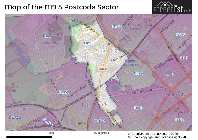
The N19 5 Postcode shares a border with N6 5 (HORNSEY , ISLINGTON , LONDON ), N6 6 (LONDON ), N7 0 (ISLINGTON , LONDON ), NW5 1 (LONDON , ISLINGTON ), N19 3 (ISLINGTON ), N19 4 (ISLINGTON ) and NW5 2 (LONDON ).
The sector is within the post town of LONDON.
N19 5 is a postcode sector within the N19 postcode district which is within the N North London postcode area.
The Royal Mail delivery office for the N19 5 postal sector is the Upper Holloway Sdelivery Office.
The area of the N19 5 postcode sector is 0.33 square miles which is 0.87 square kilometres or 214.10 square acres.

Map of the N19 5 Postcode Sector
Explore the N19 5 postcode sector by using our free interactive map.
| N | 1 | 9 | - | 5 | X | X |
| N | 1 | 9 | Space | 5 | Letter | Letter |
Official List of Streets
Islington (64 Streets)
Camden (13 Streets)
Unofficial Streets or Alternative Spellings
Islington
ANSON ROAD HUDDLESTON ROAD PLESHEY ROAD BOVINGTON CLOSE BOVINGTON DRIVE BROOKSIDE ROAD FULBROOK ROAD MAYWEATHER COURT MIDDLE WAY NORTH COURTYARD SANDRIDGE STREET SOUTH COURTYARD ST JOHNS WAY STANDSTONE PLACE TOLLHOUSE WAYCamden
BRAMSHILL GARDENS BURGHLEY ROAD CROFTDOWN ROAD DARTMOUTH PARK AVENUE FORTESS ROAD HIGHGATE HILL LADY MARGARET ROAD LUPTON STREET MONTPELIER GROVE OSPRINGE ROADHaringey
HORNSEY LANEWeather Forecast for N19 5
Press Button to Show Forecast for Arsenal F.C.
| Time Period | Icon | Description | Temperature | Rain Probability | Wind |
|---|---|---|---|---|---|
| 06:00 to 09:00 | Cloudy | 10.0°C (feels like 8.0°C) | 53.00% | WNW 9 mph | |
| 09:00 to 12:00 | Cloudy | 11.0°C (feels like 8.0°C) | 8.00% | NW 13 mph | |
| 12:00 to 15:00 | Cloudy | 12.0°C (feels like 9.0°C) | 7.00% | NW 13 mph | |
| 15:00 to 18:00 | Light rain shower (day) | 12.0°C (feels like 9.0°C) | 55.00% | N 13 mph | |
| 18:00 to 21:00 | Cloudy | 10.0°C (feels like 8.0°C) | 14.00% | NNE 9 mph | |
| 21:00 to 00:00 | Partly cloudy (night) | 8.0°C (feels like 5.0°C) | 7.00% | NNE 9 mph |
Press Button to Show Forecast for Arsenal F.C.
| Time Period | Icon | Description | Temperature | Rain Probability | Wind |
|---|---|---|---|---|---|
| 00:00 to 03:00 | Clear night | 6.0°C (feels like 3.0°C) | 1.00% | N 9 mph | |
| 03:00 to 06:00 | Partly cloudy (night) | 5.0°C (feels like 2.0°C) | 1.00% | NNW 9 mph | |
| 06:00 to 09:00 | Partly cloudy (day) | 5.0°C (feels like 2.0°C) | 2.00% | NNW 9 mph | |
| 09:00 to 12:00 | Cloudy | 8.0°C (feels like 5.0°C) | 7.00% | N 11 mph | |
| 12:00 to 15:00 | Overcast | 10.0°C (feels like 7.0°C) | 8.00% | N 11 mph | |
| 15:00 to 18:00 | Overcast | 11.0°C (feels like 8.0°C) | 9.00% | N 11 mph | |
| 18:00 to 21:00 | Overcast | 10.0°C (feels like 8.0°C) | 7.00% | NNE 9 mph | |
| 21:00 to 00:00 | Partly cloudy (night) | 8.0°C (feels like 6.0°C) | 1.00% | NNE 7 mph |
Press Button to Show Forecast for Arsenal F.C.
| Time Period | Icon | Description | Temperature | Rain Probability | Wind |
|---|---|---|---|---|---|
| 00:00 to 03:00 | Cloudy | 6.0°C (feels like 5.0°C) | 6.00% | NNE 4 mph | |
| 03:00 to 06:00 | Partly cloudy (night) | 6.0°C (feels like 4.0°C) | 2.00% | NNW 4 mph | |
| 06:00 to 09:00 | Overcast | 6.0°C (feels like 4.0°C) | 9.00% | N 4 mph | |
| 09:00 to 12:00 | Overcast | 8.0°C (feels like 6.0°C) | 9.00% | NNE 9 mph | |
| 12:00 to 15:00 | Overcast | 10.0°C (feels like 7.0°C) | 12.00% | NNE 9 mph | |
| 15:00 to 18:00 | Cloudy | 11.0°C (feels like 9.0°C) | 6.00% | NNE 11 mph | |
| 18:00 to 21:00 | Cloudy | 10.0°C (feels like 8.0°C) | 5.00% | NNE 11 mph | |
| 21:00 to 00:00 | Partly cloudy (night) | 8.0°C (feels like 6.0°C) | 2.00% | NE 9 mph |
Press Button to Show Forecast for Arsenal F.C.
| Time Period | Icon | Description | Temperature | Rain Probability | Wind |
|---|---|---|---|---|---|
| 00:00 to 03:00 | Partly cloudy (night) | 7.0°C (feels like 4.0°C) | 2.00% | NNE 7 mph | |
| 03:00 to 06:00 | Clear night | 6.0°C (feels like 3.0°C) | 1.00% | NNE 7 mph | |
| 06:00 to 09:00 | Sunny day | 6.0°C (feels like 3.0°C) | 2.00% | NNE 7 mph | |
| 09:00 to 12:00 | Cloudy | 9.0°C (feels like 6.0°C) | 5.00% | NNE 9 mph | |
| 12:00 to 15:00 | Cloudy | 11.0°C (feels like 8.0°C) | 7.00% | NE 9 mph | |
| 15:00 to 18:00 | Cloudy | 11.0°C (feels like 9.0°C) | 9.00% | NE 11 mph | |
| 18:00 to 21:00 | Cloudy | 10.0°C (feels like 8.0°C) | 7.00% | NE 11 mph | |
| 21:00 to 00:00 | Partly cloudy (night) | 8.0°C (feels like 6.0°C) | 2.00% | NE 9 mph |
Schools and Places of Education Within the N19 5 Postcode Sector
Brookfield Primary School
Community school
Chester Road, London, , N19 5DH
Head: Mrs Laurel Robin
Ofsted Rating: Good
Inspection: 2023-09-20 (212 days ago)
Website: Visit Brookfield Primary School Website
Phone: 02072729627
Number of Pupils: 394
Hargrave Park Primary School
Community school
51 Bredgar Road, London, , N19 5BS
Head: Mrs Lisa Horton
Ofsted Rating: Good
Inspection: 2023-05-25 (330 days ago)
Website: Visit Hargrave Park Primary School Website
Phone: 02072723989
Number of Pupils: 369
St John's Upper Holloway CofE Primary School
Voluntary aided school
Pemberton Gardens, London, , N19 5RR
Head: Mr Nick Turpin
Ofsted Rating: Good
Inspection: 2022-06-09 (680 days ago)
Website: Visit St John's Upper Holloway CofE Primary School Website
Phone: 02072722780
Number of Pupils: 219
St Joseph's Catholic Primary School
Voluntary aided school
Highgate Hill, London, , N19 5NE
Head: Miss Clare McFlynn
Ofsted Rating: Outstanding
Inspection: 2023-11-16 (155 days ago)
Website: Visit St Joseph's Catholic Primary School Website
Phone: 02072721270
Number of Pupils: 417
House Prices in the N19 5 Postcode Sector
| Type of Property | 2018 Average | 2018 Sales | 2017 Average | 2017 Sales | 2016 Average | 2016 Sales | 2015 Average | 2015 Sales |
|---|---|---|---|---|---|---|---|---|
| Detached | £1,272,500 | 1 | £0 | 0 | £0 | 0 | £0 | 0 |
| Semi-Detached | £895,000 | 1 | £1,590,000 | 3 | £1,471,667 | 3 | £0 | 0 |
| Terraced | £1,167,909 | 11 | £1,230,500 | 11 | £1,011,545 | 11 | £1,228,071 | 14 |
| Flats | £462,477 | 105 | £507,567 | 44 | £499,012 | 88 | £466,162 | 81 |
Important Postcodes N19 5 in the Postcode Sector
N19 5BS is the postcode for Hargrave Park Primary School, 51 Bredgar Road, Islington, Hargrave Park Extended Community School, 51 Bredgar Road, Islington, and Hargrave Park Extended Community School, 51 Bredgar Road
N19 5DD is the postcode for Archway Leisure Centre, 1 MacDonald Road
N19 5DH is the postcode for Brookfield Primary School, Chester Road, KONSTAM CHILDREN'S CENTRE, Konstam Nursery, 75 Chester Road, and Highgate Library, Chester Road
N19 5DT is the postcode for ST JOSEPHS SCHOOL, DARTMOUTH PARK HILL, ISLINGTON, St. Josephs Catholic Primary School, Dartmouth Park Hill, and St Josephs Catholic Primary School, Dartmouth Park Hill
N19 5HE is the postcode for Archway Childrens Centre, 1 Vorley Road, Islington
N19 5JG is the postcode for Camden and Islington Mental Health and Social Care Trust, Highgate Hospital
N19 5LW is the postcode for CHARTERHOUSE BUILDING, University College London, Archway Campus, 2-10 Highgate Hill, CLERKENWELL BUILDING, University College London, Archway Campus, 2-10 Highgate Hill, FURNIVAL BUILDING, University College London, Archway Campus, 2-10 Highgate Hill, and HOLBORN UNION BUILDING, University College London, Archway Campus, 2-10 Highgate Hill
N19 5NE is the postcode for St. Josephs Primary School, Highgate Hill
N19 5NF is the postcode for L BLOCK, The Whittington Hospital NHS Trust, The Whittington Hospital, G BLOCK, The Whittington Hospital NHS Trust, The Whittington Hospital, The Whittington Hospital NHS Trust, The Whittington Hospital, A BLOCK, The Whittington Hospital NHS Trust, The Whittington Hospital, H BLOCK, The Whittington Hospital NHS Trust, The Whittington Hospital, KENWOOD WING, The Whittington Hospital NHS Trust, The Whittington Hospital, W BLOCK, The Whittington Hospital NHS Trust, The Whittington Hospital, K BLOCK, The Whittington Hospital NHS Trust, The Whittington Hospital, F BLOCK, The Whittington Hospital NHS Trust, The Whittington Hospital, and HIGHGATE WING, The Whittington Hospital NHS Trust, The Whittington Hospital
N19 5PH is the postcode for Archway Library, Hamlyn House, 21 Highgate Hill
N19 5RR is the postcode for St. Johns C of E Primary School, Pemberton Gardens, JUNIOR BLOCK, St. Johns C of E Primary School, Pemberton Gardens, and MAIN BUILDING (INC. NURSERY), St. Johns C of E Primary School, Pemberton Gardens
N19 5SE is the postcode for 681-689 Holloway Road
N19 5SZ is the postcode for Ministry of Justice, Archway Tower, and 13TH & 14TH FLOOR ARCHWAY TOWER, Archway Tower, 2 Junction Road
N19 5TA is the postcode for Post Office, Upper Holloway Post Office, 14 Junction Road
N19 5UN is the postcode for Royal Mail, London North Delivery Office Unit, 11-13 Bush Industrial Estate, Station Road
| The N19 5 Sector is within these Local Authorities |
|
|---|---|
| The N19 5 Sector is within these Counties |
|
| The N19 5 Sector is within these Water Company Areas |
|