The N20 postcode district is a postal district located in the N London - N postcode area with a population of 20,114 residents according to the 2021 England and Wales Census.
The area of the N20 postcode district is 3.68 square miles which is 9.54 square kilometres or 2,356.52 acres.
Currently, the N20 district has about 532 postcode units spread across 3 geographic postcode sectors.
Given that each sector allows for 400 unique postcode combinations, the district has a capacity of 1,200 postcodes. With 532 postcodes already in use, this leaves 668 units available.
The N20 postal code covers the settlement of WHETSTONE.
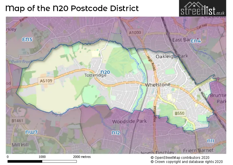
The N20 Postcode shares a border with EN5 (BARNET, NEW BARNET), EN4 (EAST BARNET, NEW BARNET, ENFIELD), N11 (NEW SOUTHGATE, SOUTHGATE, WOOD GREEN), N12 (NORTH FINCHLEY) and NW7 (MILL HILL).
The primary settlement in the N20 postcode district is Barnet, located in Greater London. Other significant settlements in the district include Barnet. The most significant post town in the district is London of Greater London.
For the district N20, we have data on 4 postcode sectors. Here's a breakdown: The sector N20 0, covers Barnet in Greater London. The sector N20 2 is non-geographic. It's often designated for PO Boxes, large organisations, or special services. The sector N20 8, covers Barnet in Greater London. The sector N20 9, covers Barnet in Greater London.

Map of the N20 Postcode District
Explore the N20 postcode district by using our free interactive map.
When it comes to local government, postal geography often disregards political borders. However, for a breakdown in the N20 District: the district mostly encompasses the Barnet London Boro area with a total of 538 postcodes.
Recent House Sales in N20
| Date | Price | Address |
|---|---|---|
| 20/10/2023 | £360,000 | Porch Way, London, N20 0DS |
| 08/09/2023 | £640,000 | Russell Lane, London, N20 0AU |
| 08/09/2023 | £1,691,681 | Greenway, London, N20 8EJ |
| 08/09/2023 | £405,000 | Acton Walk, London, N20 9BL |
| 07/09/2023 | £415,000 | High Road, London, N20 0QZ |
| 31/08/2023 | £350,000 | Capel Close, London, N20 0QU |
| 30/08/2023 | £1,700,000 | Church Way, London, N20 0JZ |
| 25/08/2023 | £285,000 | Farnham Close, London, N20 9PQ |
| 24/08/2023 | £1,230,000 | Buckingham Avenue, London, N20 9DG |
| 24/08/2023 | £1,050,000 | Well Grove, London, N20 9BN |
Weather Forecast for N20
Press Button to Show Forecast for Barnet
| Time Period | Icon | Description | Temperature | Rain Probability | Wind |
|---|---|---|---|---|---|
| 12:00 to 15:00 | Overcast | 9.0°C (feels like 7.0°C) | 13.00% | W 11 mph | |
| 15:00 to 18:00 | Cloudy | 9.0°C (feels like 7.0°C) | 49.00% | NW 9 mph | |
| 18:00 to 21:00 | Cloudy | 7.0°C (feels like 5.0°C) | 44.00% | NNE 7 mph | |
| 21:00 to 00:00 | Cloudy | 6.0°C (feels like 4.0°C) | 7.00% | ENE 7 mph |
Press Button to Show Forecast for Barnet
| Time Period | Icon | Description | Temperature | Rain Probability | Wind |
|---|---|---|---|---|---|
| 00:00 to 03:00 | Cloudy | 5.0°C (feels like 3.0°C) | 4.00% | NE 7 mph | |
| 03:00 to 06:00 | Cloudy | 3.0°C (feels like 1.0°C) | 4.00% | NE 7 mph | |
| 06:00 to 09:00 | Partly cloudy (day) | 3.0°C (feels like 0.0°C) | 1.00% | NE 7 mph | |
| 09:00 to 12:00 | Partly cloudy (day) | 7.0°C (feels like 4.0°C) | 2.00% | ENE 7 mph | |
| 12:00 to 15:00 | Cloudy | 10.0°C (feels like 8.0°C) | 9.00% | ENE 7 mph | |
| 15:00 to 18:00 | Overcast | 10.0°C (feels like 9.0°C) | 14.00% | ENE 4 mph | |
| 18:00 to 21:00 | Cloudy | 9.0°C (feels like 7.0°C) | 11.00% | ENE 7 mph | |
| 21:00 to 00:00 | Cloudy | 6.0°C (feels like 4.0°C) | 11.00% | E 7 mph |
Press Button to Show Forecast for Barnet
| Time Period | Icon | Description | Temperature | Rain Probability | Wind |
|---|---|---|---|---|---|
| 00:00 to 03:00 | Cloudy | 4.0°C (feels like 2.0°C) | 12.00% | ENE 7 mph | |
| 03:00 to 06:00 | Cloudy | 4.0°C (feels like 1.0°C) | 18.00% | NE 7 mph | |
| 06:00 to 09:00 | Cloudy | 4.0°C (feels like 1.0°C) | 20.00% | NE 9 mph | |
| 09:00 to 12:00 | Overcast | 8.0°C (feels like 6.0°C) | 19.00% | ENE 9 mph | |
| 12:00 to 15:00 | Overcast | 11.0°C (feels like 8.0°C) | 20.00% | E 9 mph | |
| 15:00 to 18:00 | Cloudy | 11.0°C (feels like 9.0°C) | 21.00% | E 11 mph | |
| 18:00 to 21:00 | Cloudy | 10.0°C (feels like 8.0°C) | 23.00% | ENE 11 mph | |
| 21:00 to 00:00 | Light rain | 8.0°C (feels like 5.0°C) | 51.00% | NE 13 mph |
Press Button to Show Forecast for Barnet
| Time Period | Icon | Description | Temperature | Rain Probability | Wind |
|---|---|---|---|---|---|
| 00:00 to 03:00 | Heavy rain | 8.0°C (feels like 5.0°C) | 73.00% | NE 11 mph | |
| 03:00 to 06:00 | Light rain | 8.0°C (feels like 6.0°C) | 55.00% | E 9 mph | |
| 06:00 to 09:00 | Cloudy | 9.0°C (feels like 6.0°C) | 41.00% | SE 9 mph | |
| 09:00 to 12:00 | Light rain shower (day) | 10.0°C (feels like 8.0°C) | 46.00% | SE 9 mph | |
| 12:00 to 15:00 | Heavy rain shower (day) | 11.0°C (feels like 9.0°C) | 62.00% | S 9 mph | |
| 15:00 to 18:00 | Light rain shower (day) | 13.0°C (feels like 10.0°C) | 42.00% | SW 11 mph | |
| 18:00 to 21:00 | Cloudy | 11.0°C (feels like 9.0°C) | 17.00% | SW 11 mph | |
| 21:00 to 00:00 | Overcast | 9.0°C (feels like 7.0°C) | 11.00% | WSW 9 mph |
Where is the N20 Postcode District?
The data shows that the postcode district N20 is located in the town of London. It is approximately 8.98 miles away from the center of London. In relation to nearby towns, it is close to Whetstone, Totteridge, Southhover to Arlington, Station Road to Longmore Avenue, and New Barnet.
The district is within the post town of LONDON.
The sector has postcodes within the nation of England.
The N20 Postcode District is in the Barnet region of Outer London - West and North West within the London.
You may be interested in our page explaining the evolution of London's Postcodes| Postcode Sector | Delivery Office |
|---|---|
| N20 0 | Whetstone Sdelivery Office |
| N20 8 | Whetstone Sdelivery Office |
| N20 9 | Whetstone Sdelivery Office |
| N | 2 | 0 | - | X | X | X |
| N | 2 | 0 | Space | Numeric | Letter | Letter |
Current Monthly Rental Prices
| # Bedrooms | Min Price | Max Price | Avg Price |
|---|---|---|---|
| £1,100 | £1,700 | £1,400 | |
| 1 | £1,350 | £1,600 | £1,479 |
| 2 | £1,650 | £4,000 | £2,184 |
| 3 | £1,995 | £6,500 | £3,481 |
| 4 | £3,200 | £13,000 | £7,459 |
| 5 | £3,400 | £9,500 | £6,288 |
| 6 | £4,000 | £27,500 | £10,566 |
Current House Prices
| # Bedrooms | Min Price | Max Price | Avg Price |
|---|---|---|---|
| £35,000 | £35,000 | £35,000 | |
| 1 | £95,000 | £795,000 | £302,959 |
| 2 | £138,750 | £995,000 | £540,616 |
| 3 | £400,000 | £1,350,000 | £829,889 |
| 4 | £525,000 | £2,500,000 | £1,226,585 |
| 5 | £1,100,000 | £8,000,000 | £2,476,664 |
| 6 | £1,000,000 | £8,000,000 | £5,214,333 |
| 7 | £3,450,000 | £8,000,000 | £4,966,667 |
| 8 | £4,500,000 | £19,995,000 | £10,831,667 |
Estate Agents who Operate in the N20 District
| Logo | Name | Brand Name | Address | Contact Number | Total Properties |
|---|---|---|---|---|---|
 | Totteridge | Statons | 28-30 Totteridge Lane, London, N20 9QJ | 020 3869 4080 | 33 |
 | Whetstone | Barnard Marcus | 1285 High Road, Whetstone, London, N20 9HS | 020 3872 3533 | 23 |
 | Totteridge | Chancellors | 42 Totteridge Lane London N20 9QJ | 020 3871 8926 | 18 |
 | Totteridge | Real Estates | 32 Totteridge Lane London N20 9QJ | 020 3906 2143 | 16 |
 | Whetstone | Martyn Gerrard | 1286 High Road, London, N20 9HH | 020 3907 9893 | 16 |
| Type of Property | 2018 Average | 2018 Sales | 2017 Average | 2017 Sales | 2016 Average | 2016 Sales | 2015 Average | 2015 Sales |
|---|---|---|---|---|---|---|---|---|
| Detached | £1,199,256 | 39 | £1,558,763 | 56 | £1,499,156 | 49 | £1,487,714 | 42 |
| Semi-Detached | £831,636 | 44 | £906,951 | 82 | £876,647 | 68 | £734,397 | 80 |
| Terraced | £668,382 | 66 | £599,725 | 49 | £524,373 | 75 | £564,424 | 38 |
| Flats | £427,840 | 145 | £438,895 | 226 | £335,634 | 103 | £332,229 | 107 |