The N22 5 postcode sector is within the county of Greater London.
Did you know? According to the 2021 Census, the N22 5 postcode sector is home to a bustling 13,279 residents!
Given that each sector allows for 400 unique postcode combinations. Letters C, I, K, M, O and V are not allowed in the last two letters of a postcode. With 196 postcodes already in use, this leaves 204 units available.
The N22 5 postal code covers the settlement of WOOD GREEN .
The N22 5 Postcode shares a border with N22 6 (WOOD GREEN , TOTTENHAM ), N22 8 (WOOD GREEN , SOUTHGATE ), N13 6 (SOUTHGATE , TOTTENHAM , WOOD GREEN ), N17 6 (TOTTENHAM ) and N17 7 (TOTTENHAM ).
The sector is within the post town of LONDON.
N22 5 is a postcode sector within the N22 postcode district which is within the N North London postcode area.
The Royal Mail delivery office for the N22 5 postal sector is the Wood Green Sdelivery Office.
The area of the N22 5 postcode sector is 0.50 square miles which is 1.30 square kilometres or 321.03 square acres.

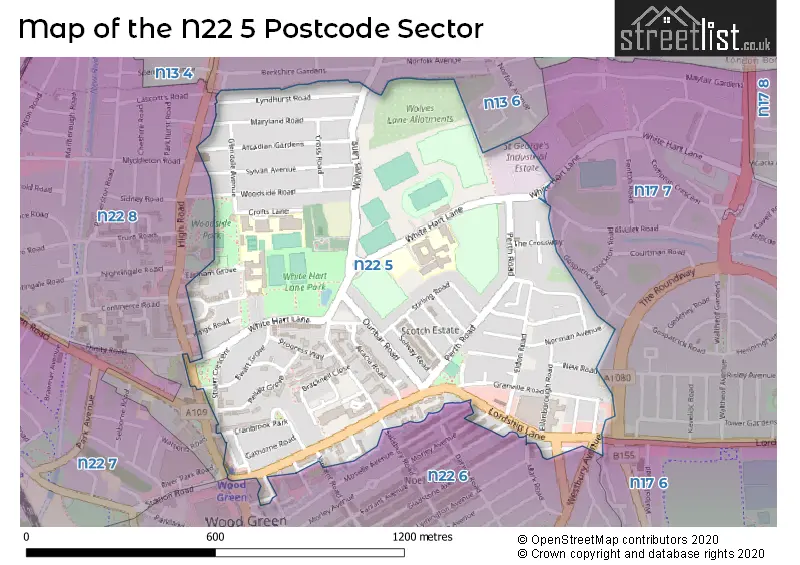
Map of the N22 5 Postcode Sector
Explore the N22 5 postcode sector by using our free interactive map.
| N | 2 | 2 | - | 5 | X | X |
| N | 2 | 2 | Space | 5 | Letter | Letter |
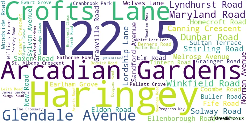
Official List of Streets
Haringey (58 Streets)
Unofficial Streets or Alternative Spellings
Haringey
BOREHAM ROAD FARRANT AVENUE GLADSTONE AVENUE HIGH ROAD MARK ROAD MORLEY AVENUE MOSELLE AVENUE REDVERS ROAD RIVULET ROAD SALISBURY ROAD STATION ROAD THE ROUNDWAY TRINITY ROAD VINCENT ROAD WESTBURY AVENUE CHAPMAN GREEN CROSS ROAD CROWN CLOSE ERIN MEWS KHALSA COURT LIBERTY MEWS NEWMAN MEWS NEWNHAM GREEN SANDRA CLOSE SWAFFHAM WAY VINCENT SQUAREEnfield
WOLVES LANEWeather Forecast for N22 5
Press Button to Show Forecast for Wood Green
| Time Period | Icon | Description | Temperature | Rain Probability | Wind |
|---|---|---|---|---|---|
| 09:00 to 12:00 | Cloudy | 8.0°C (feels like 5.0°C) | 4.00% | NNW 11 mph | |
| 12:00 to 15:00 | Cloudy | 10.0°C (feels like 8.0°C) | 4.00% | NNW 11 mph | |
| 15:00 to 18:00 | Cloudy | 11.0°C (feels like 8.0°C) | 5.00% | NNW 11 mph | |
| 18:00 to 21:00 | Cloudy | 10.0°C (feels like 8.0°C) | 3.00% | N 7 mph | |
| 21:00 to 00:00 | Partly cloudy (night) | 7.0°C (feels like 6.0°C) | 1.00% | NE 4 mph |
Press Button to Show Forecast for Wood Green
| Time Period | Icon | Description | Temperature | Rain Probability | Wind |
|---|---|---|---|---|---|
| 00:00 to 03:00 | Cloudy | 6.0°C (feels like 5.0°C) | 4.00% | WSW 4 mph | |
| 03:00 to 06:00 | Cloudy | 6.0°C (feels like 4.0°C) | 4.00% | WSW 4 mph | |
| 06:00 to 09:00 | Cloudy | 6.0°C (feels like 4.0°C) | 4.00% | WSW 7 mph | |
| 09:00 to 12:00 | Cloudy | 9.0°C (feels like 7.0°C) | 6.00% | W 9 mph | |
| 12:00 to 15:00 | Cloudy | 11.0°C (feels like 9.0°C) | 9.00% | WNW 9 mph | |
| 15:00 to 18:00 | Cloudy | 12.0°C (feels like 10.0°C) | 9.00% | WNW 9 mph | |
| 18:00 to 21:00 | Cloudy | 11.0°C (feels like 9.0°C) | 9.00% | NW 7 mph | |
| 21:00 to 00:00 | Cloudy | 8.0°C (feels like 7.0°C) | 7.00% | NNE 4 mph |
Press Button to Show Forecast for Wood Green
| Time Period | Icon | Description | Temperature | Rain Probability | Wind |
|---|---|---|---|---|---|
| 00:00 to 03:00 | Cloudy | 7.0°C (feels like 5.0°C) | 5.00% | NNE 4 mph | |
| 03:00 to 06:00 | Cloudy | 6.0°C (feels like 4.0°C) | 5.00% | NE 4 mph | |
| 06:00 to 09:00 | Cloudy | 6.0°C (feels like 4.0°C) | 7.00% | ENE 4 mph | |
| 09:00 to 12:00 | Cloudy | 8.0°C (feels like 7.0°C) | 9.00% | ESE 7 mph | |
| 12:00 to 15:00 | Overcast | 11.0°C (feels like 9.0°C) | 13.00% | SE 7 mph | |
| 15:00 to 18:00 | Cloudy | 11.0°C (feels like 9.0°C) | 16.00% | SE 7 mph | |
| 18:00 to 21:00 | Cloudy | 10.0°C (feels like 8.0°C) | 13.00% | ESE 9 mph | |
| 21:00 to 00:00 | Cloudy | 9.0°C (feels like 7.0°C) | 12.00% | ESE 7 mph |
Press Button to Show Forecast for Wood Green
| Time Period | Icon | Description | Temperature | Rain Probability | Wind |
|---|---|---|---|---|---|
| 00:00 to 03:00 | Cloudy | 8.0°C (feels like 6.0°C) | 14.00% | ESE 7 mph | |
| 03:00 to 06:00 | Cloudy | 8.0°C (feels like 6.0°C) | 15.00% | E 4 mph | |
| 06:00 to 09:00 | Cloudy | 8.0°C (feels like 6.0°C) | 14.00% | E 7 mph | |
| 09:00 to 12:00 | Cloudy | 11.0°C (feels like 9.0°C) | 14.00% | SE 7 mph | |
| 12:00 to 15:00 | Light rain | 13.0°C (feels like 11.0°C) | 40.00% | ESE 9 mph | |
| 15:00 to 18:00 | Light rain shower (day) | 13.0°C (feels like 11.0°C) | 37.00% | ESE 9 mph | |
| 18:00 to 21:00 | Light rain shower (day) | 12.0°C (feels like 11.0°C) | 33.00% | ESE 9 mph | |
| 21:00 to 00:00 | Cloudy | 11.0°C (feels like 9.0°C) | 15.00% | ESE 7 mph |
Schools and Places of Education Within the N22 5 Postcode Sector
Earlham Primary School
Community school
Earlham Grove, London, Middlesex, N22 5HJ
Head: Miss Natasha Rezai
Ofsted Rating: Good
Inspection: 2022-06-30 (664 days ago)
Website: Visit Earlham Primary School Website
Phone: 02088882780
Number of Pupils: 290
Footsteps Trust
Other independent school
New River Sports Centre, London, , N22 5QW
Head: Mr Christopher Hall
Ofsted Rating: Good
Inspection: 2022-07-15 (649 days ago)
Website: Visit Footsteps Trust Website
Phone: 02088814050
Number of Pupils: 26
Lordship Lane Primary School
Community school
Ellenborough Road, Wood Green, , N22 5PS
Head: Mrs Michelle Randles
Ofsted Rating: Good
Inspection: 2023-04-26 (364 days ago)
Website: Visit Lordship Lane Primary School Website
Phone: 02088886541
Number of Pupils: 517
Mulberry Academy Woodside
Academy converter
White Hart Lane, London, , N22 5QJ
Head: Ms Angela Wallace
Ofsted Rating: Good
Inspection: 2022-02-23 (791 days ago)
Website: Visit Mulberry Academy Woodside Website
Phone: 02088896761
Number of Pupils: 1193
Riverside School
Community special school
White Hart Lane, London, , N22 5QJ
Head: Mr Martin Doyle
Ofsted Rating: Good
Inspection: 2022-03-30 (756 days ago)
Website: Visit Riverside School Website
Phone: 02088897814
Number of Pupils: 157
St Thomas More Catholic School
Academy converter
Glendale Avenue, London, , N22 5HN
Head: Mr Martin Tissot
Ofsted Rating: Outstanding
Inspection: 2013-06-19 (3962 days ago)
Website: Visit St Thomas More Catholic School Website
Phone: 02088887122
Number of Pupils: 1300
House Prices in the N22 5 Postcode Sector
| Type of Property | 2018 Average | 2018 Sales | 2017 Average | 2017 Sales | 2016 Average | 2016 Sales | 2015 Average | 2015 Sales |
|---|---|---|---|---|---|---|---|---|
| Detached | £0 | 0 | £1,000,000 | 2 | £0 | 0 | £0 | 0 |
| Semi-Detached | £703,000 | 3 | £615,333 | 3 | £602,600 | 5 | £564,000 | 8 |
| Terraced | £566,082 | 43 | £522,411 | 51 | £550,037 | 52 | £460,666 | 54 |
| Flats | £379,468 | 50 | £350,245 | 63 | £350,983 | 69 | £315,288 | 80 |
Important Postcodes N22 5 in the Postcode Sector
N22 5HJ is the postcode for Earlham Primary School, Earlham Grove, ANNEX, Earlham Primary School, Earlham Grove, and CANTEEN, Earlham Primary School, Earlham Grove
N22 5HN is the postcode for Canteen Building, St Thomas More Catholic School, Glendale Avenue, Main Building, St Thomas More Catholic School, Glendale Avenue, and St Thomas More Catholic School, Glendale Avenue
N22 5LF is the postcode for Wood Green Crown Court, Lordship Lane
N22 5NJ is the postcode for Stuart Crescent Health Centre, 8 Stuart Crescent
N22 5PS is the postcode for Lordship Lane Primary School, Ellenborough Road
N22 5QJ is the postcode for WEST BLOCK, Woodside High School, White Hart Lane, CEDAR & WILLOW BLOCK, Woodside High School, White Hart Lane, Woodside High School, White Hart Lane, SPORTS HALL, Woodside High School, White Hart Lane, RIVERSIDE SCHOOL & SPORTS HALL, Woodside High School, White Hart Lane, WILLOW BLOCK, Woodside High School, White Hart Lane, and BIRCH & ASH BLOCK, Woodside High School, White Hart Lane
N22 5QL is the postcode for Haringey Occupational Therapy Service, Unit 5, White Hart Lane, St. Georges Industrial Estate
N22 5QW is the postcode for Old Pavilion, New River Sport & Fitness, White Hart Lane, Main Grandstand Building, New River Sport & Fitness, White Hart Lane, and White Hart Lane Community Sports Centre, White Hart Lane
N22 5RP is the postcode for Maya Angelou Family Contact Centre, 39 Winkfield Road, and Winkfield Resource Centre, 33, Winkfield Road
| The N22 5 Sector is within these Local Authorities |
|
|---|---|
| The N22 5 Sector is within these Counties |
|
| The N22 5 Sector is within these Water Company Areas |
|