The N22 8 postcode sector is within the county of Greater London.
Did you know? According to the 2021 Census, the N22 8 postcode sector is home to a bustling 9,724 residents!
Given that each sector allows for 400 unique postcode combinations. Letters C, I, K, M, O and V are not allowed in the last two letters of a postcode. With 163 postcodes already in use, this leaves 237 units available.
The largest settlements in the N22 8 postal code are WOOD GREEN and SOUTHGATE .
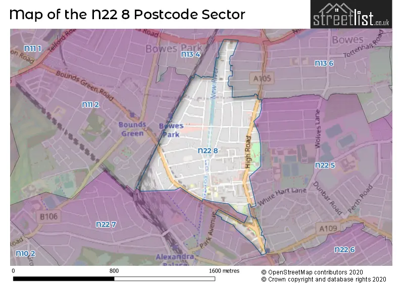
The N22 8 Postcode shares a border with N22 5 (WOOD GREEN ), N22 6 (WOOD GREEN , TOTTENHAM ), N22 7 (WOOD GREEN , HORNSEY ), N13 4 (SOUTHGATE ), N13 6 (SOUTHGATE , TOTTENHAM , WOOD GREEN ) and N11 2 (WOOD GREEN , SOUTHGATE , NEW SOUTHGATE ).
The sector is within the post town of LONDON.
N22 8 is a postcode sector within the N22 postcode district which is within the N North London postcode area.
The Royal Mail delivery office for the N22 8 postal sector is the Wood Green Sdelivery Office.
The area of the N22 8 postcode sector is 0.30 square miles which is 0.78 square kilometres or 193.19 square acres.
Waterways within the N22 8 postcode sector include the New River.


Map of the N22 8 Postcode Sector
Explore the N22 8 postcode sector by using our free interactive map.
| N | 2 | 2 | - | 8 | X | X |
| N | 2 | 2 | Space | 8 | Letter | Letter |
Official List of Streets
Haringey (35 Streets)
Unofficial Streets or Alternative Spellings
Haringey
ARCADIAN GARDENS BRAEMAR AVENUE CANNING CRESCENT CORNWALL AVENUE CRANBROOK PARK EARLHAM GROVE EASTERN ROAD EWART GROVE HARDY PASSAGE KINGS ROAD LEVERTON CLOSE LYNDHURST ROAD MARYLAND ROAD NORTHCOTT AVENUE RIVER PARK ROAD SELBORNE ROAD STUART CRESCENT SYLVAN AVENUE WATSONS ROAD WHITE HART LANE WOODSIDE ROAD ADAMS MEWS CAMERON PLACE CHRISTOPHER PLACE FINSBURY COTTAGES GRASMERE COURT HOMELINK TERRACE LLOYD THOMAS COURT MOHR COURT NATALIE MEWS NEVILLE PLACE OMEGA TERRACE WYNAUD COURTEnfield
BELSIZE AVENUE BOWES ROAD KELVIN AVENUE MELBOURNE AVENUE RUSSELL ROAD SIDNEY AVENUE SPENCER AVENUEWeather Forecast for N22 8
Press Button to Show Forecast for Wood Green
| Time Period | Icon | Description | Temperature | Rain Probability | Wind |
|---|---|---|---|---|---|
| 06:00 to 09:00 | Partly cloudy (day) | 5.0°C (feels like 2.0°C) | 1.00% | NNW 9 mph | |
| 09:00 to 12:00 | Cloudy | 8.0°C (feels like 5.0°C) | 4.00% | NNW 11 mph | |
| 12:00 to 15:00 | Cloudy | 10.0°C (feels like 8.0°C) | 4.00% | NNW 11 mph | |
| 15:00 to 18:00 | Cloudy | 11.0°C (feels like 8.0°C) | 5.00% | NNW 11 mph | |
| 18:00 to 21:00 | Cloudy | 10.0°C (feels like 8.0°C) | 3.00% | N 7 mph | |
| 21:00 to 00:00 | Partly cloudy (night) | 7.0°C (feels like 6.0°C) | 1.00% | NE 4 mph |
Press Button to Show Forecast for Wood Green
| Time Period | Icon | Description | Temperature | Rain Probability | Wind |
|---|---|---|---|---|---|
| 00:00 to 03:00 | Cloudy | 6.0°C (feels like 5.0°C) | 4.00% | WSW 4 mph | |
| 03:00 to 06:00 | Cloudy | 6.0°C (feels like 4.0°C) | 4.00% | WSW 4 mph | |
| 06:00 to 09:00 | Cloudy | 6.0°C (feels like 4.0°C) | 4.00% | WSW 7 mph | |
| 09:00 to 12:00 | Cloudy | 9.0°C (feels like 7.0°C) | 6.00% | W 9 mph | |
| 12:00 to 15:00 | Cloudy | 11.0°C (feels like 9.0°C) | 9.00% | WNW 9 mph | |
| 15:00 to 18:00 | Cloudy | 12.0°C (feels like 10.0°C) | 9.00% | WNW 9 mph | |
| 18:00 to 21:00 | Cloudy | 11.0°C (feels like 9.0°C) | 9.00% | NW 7 mph | |
| 21:00 to 00:00 | Cloudy | 8.0°C (feels like 7.0°C) | 7.00% | NNE 4 mph |
Press Button to Show Forecast for Wood Green
| Time Period | Icon | Description | Temperature | Rain Probability | Wind |
|---|---|---|---|---|---|
| 00:00 to 03:00 | Cloudy | 7.0°C (feels like 5.0°C) | 5.00% | NNE 4 mph | |
| 03:00 to 06:00 | Cloudy | 6.0°C (feels like 4.0°C) | 5.00% | NE 4 mph | |
| 06:00 to 09:00 | Cloudy | 6.0°C (feels like 4.0°C) | 7.00% | ENE 4 mph | |
| 09:00 to 12:00 | Cloudy | 8.0°C (feels like 7.0°C) | 9.00% | ESE 7 mph | |
| 12:00 to 15:00 | Overcast | 11.0°C (feels like 9.0°C) | 13.00% | SE 7 mph | |
| 15:00 to 18:00 | Cloudy | 11.0°C (feels like 9.0°C) | 16.00% | SE 7 mph | |
| 18:00 to 21:00 | Cloudy | 10.0°C (feels like 8.0°C) | 13.00% | ESE 9 mph | |
| 21:00 to 00:00 | Cloudy | 9.0°C (feels like 7.0°C) | 12.00% | ESE 7 mph |
Press Button to Show Forecast for Wood Green
| Time Period | Icon | Description | Temperature | Rain Probability | Wind |
|---|---|---|---|---|---|
| 00:00 to 03:00 | Cloudy | 8.0°C (feels like 6.0°C) | 14.00% | ESE 7 mph | |
| 03:00 to 06:00 | Cloudy | 8.0°C (feels like 6.0°C) | 15.00% | E 4 mph | |
| 06:00 to 09:00 | Cloudy | 8.0°C (feels like 6.0°C) | 14.00% | E 7 mph | |
| 09:00 to 12:00 | Cloudy | 11.0°C (feels like 9.0°C) | 14.00% | SE 7 mph | |
| 12:00 to 15:00 | Light rain | 13.0°C (feels like 11.0°C) | 40.00% | ESE 9 mph | |
| 15:00 to 18:00 | Light rain shower (day) | 13.0°C (feels like 11.0°C) | 37.00% | ESE 9 mph | |
| 18:00 to 21:00 | Light rain shower (day) | 12.0°C (feels like 11.0°C) | 33.00% | ESE 9 mph | |
| 21:00 to 00:00 | Cloudy | 11.0°C (feels like 9.0°C) | 15.00% | ESE 7 mph |
Schools and Places of Education Within the N22 8 Postcode Sector
Greek Secondary School of London
Other independent school
22 Trinity road, London, , N22 8LB
Head: Ms Maria Komninou
Ofsted Rating: Good
Inspection: 2019-05-17 (1804 days ago)
Website: Visit Greek Secondary School of London Website
Phone: 02088819320
Number of Pupils: 60
Haringey Learning Partnership
Pupil referral unit
Commerce Road, London, , N22 8DZ
Head: Ms Gerry Robinson
Ofsted Rating: Good
Inspection: 2018-04-24 (2192 days ago)
Website: Visit Haringey Learning Partnership Website
Phone: 02088299846
Number of Pupils: 53
St Michael's CofE Primary School
Academy converter
Bounds Green Road, London, , N22 8HE
Head: Mr Simon Knowles
Ofsted Rating: Good
Inspection: 2020-01-16 (1560 days ago)
Website: Visit St Michael's CofE Primary School Website
Phone: 02088887125
Number of Pupils: 138
Trinity Primary Academy
Academy sponsor led
Bounds Green Road, London, , N22 8ES
Head: Ms Melissa Martinez
Ofsted Rating: Outstanding
Inspection: 2023-02-03 (446 days ago)
Website: Visit Trinity Primary Academy Website
Phone: 02088883736
Number of Pupils: 475
House Prices in the N22 8 Postcode Sector
| Type of Property | 2018 Average | 2018 Sales | 2017 Average | 2017 Sales | 2016 Average | 2016 Sales | 2015 Average | 2015 Sales |
|---|---|---|---|---|---|---|---|---|
| Detached | £754,500 | 2 | £665,000 | 1 | £808,333 | 3 | £570,000 | 2 |
| Semi-Detached | £734,000 | 2 | £699,781 | 8 | £683,750 | 6 | £692,750 | 4 |
| Terraced | £592,966 | 22 | £643,900 | 15 | £679,568 | 14 | £489,336 | 29 |
| Flats | £353,155 | 61 | £414,203 | 44 | £365,979 | 72 | £318,127 | 97 |
Important Postcodes N22 8 in the Postcode Sector
N22 8EP is the postcode for Community Centre, 52 Commerce Road
N22 8ES is the postcode for Trinity Primary Academy, Bounds Green Road
N22 8HE is the postcode for St. Michaels C of E Junior & Infant School, Bounds Green Road, and St Michael's CE Primary School, Bounds Green Road
N22 8HQ is the postcode for Family Housing Association, River Park House, 225 High Road, and River Park House, 225 High Road
N22 8JA is the postcode for Wood Green Custody Centre, 347 High Road, Wood Green, Metropolitan Police, Wood Green Custody Centre, 347 High Road, and WOOD GREEN CUSTODY CENTRE, 347 High Road
N22 8JT is the postcode for 276 High Road
N22 8LE is the postcode for Civic Centre, High Road
| The N22 8 Sector is within these Local Authorities |
|
|---|---|
| The N22 8 Sector is within these Counties |
|
| The N22 8 Sector is within these Water Company Areas |
|