The N4 4 postcode sector is within the county of Greater London.
Did you know? According to the 2021 Census, the N4 4 postcode sector is home to a bustling 7,220 residents!
Given that each sector allows for 400 unique postcode combinations. Letters C, I, K, M, O and V are not allowed in the last two letters of a postcode. With 134 postcodes already in use, this leaves 266 units available.
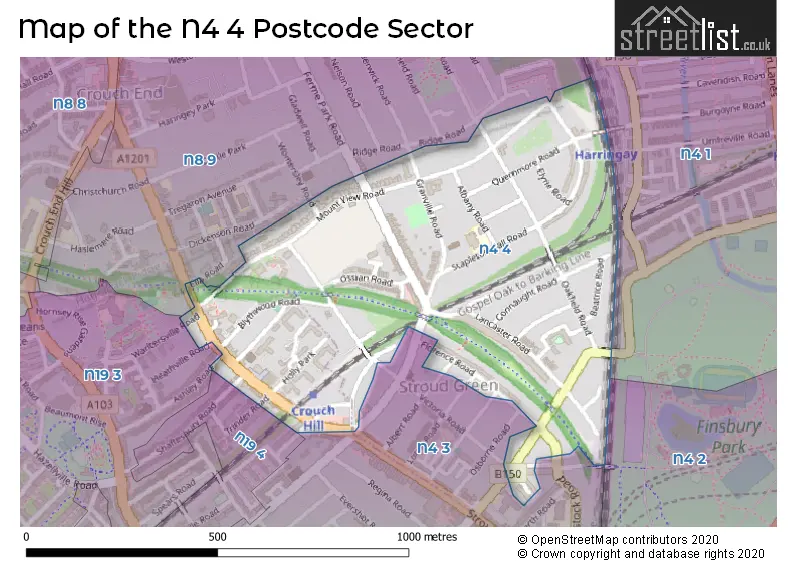
The largest settlements in the N4 4 postal code are HORNSEY and ISLINGTON .
The N4 4 Postcode shares a border with N4 3 (ISLINGTON , HORNSEY ), N4 1 (TOTTENHAM , HORNSEY , HACKNEY ), N8 9 (HORNSEY , ISLINGTON ), N4 2 (HACKNEY , ISLINGTON ), N19 3 (ISLINGTON ) and N19 4 (ISLINGTON ).
The sector is within the post town of LONDON.
N4 4 is a postcode sector within the N4 postcode district which is within the N North London postcode area.
The Royal Mail delivery office for the N4 4 postal sector is the Finsbury Park Sdelivery Office.
The area of the N4 4 postcode sector is 0.27 square miles which is 0.69 square kilometres or 171.42 square acres.

Map of the N4 4 Postcode Sector
Explore the N4 4 postcode sector by using our free interactive map.
| N | 4 | - | 4 | X | X |
| N | 4 | Space | 4 | Letter | Letter |
Official List of Streets
Haringey (26 Streets)
Unofficial Streets or Alternative Spellings
Haringey
ALBERT ROAD CROUCH HILL ENDYMION ROAD LORNE ROAD MARQUIS ROAD OXFORD ROAD VICTORIA ROAD WOMERSLEY ROAD WOODSTOCK ROAD BRIDGEMOUNT MEWS CHURCHHILL CRESCENT DARREN CLOSE PARKLAND WALKIslington
ASHLEY ROAD ELLA ROAD HEATHVILLE ROAD SHAFTESBURY ROAD SPARSHOLT ROAD TRINDER ROAD WARLTERSVILLE ROADWeather Forecast for N4 4
Press Button to Show Forecast for Harringay
| Time Period | Icon | Description | Temperature | Rain Probability | Wind |
|---|---|---|---|---|---|
| 21:00 to 00:00 | Cloudy | 7.0°C (feels like 7.0°C) | 4.00% | NE 4 mph |
Press Button to Show Forecast for Harringay
| Time Period | Icon | Description | Temperature | Rain Probability | Wind |
|---|---|---|---|---|---|
| 00:00 to 03:00 | Cloudy | 7.0°C (feels like 6.0°C) | 5.00% | SSE 4 mph | |
| 03:00 to 06:00 | Cloudy | 7.0°C (feels like 5.0°C) | 5.00% | SSW 7 mph | |
| 06:00 to 09:00 | Cloudy | 7.0°C (feels like 5.0°C) | 7.00% | SW 7 mph | |
| 09:00 to 12:00 | Cloudy | 9.0°C (feels like 8.0°C) | 10.00% | W 7 mph | |
| 12:00 to 15:00 | Overcast | 11.0°C (feels like 9.0°C) | 10.00% | W 11 mph | |
| 15:00 to 18:00 | Light rain shower (day) | 11.0°C (feels like 9.0°C) | 49.00% | WNW 9 mph | |
| 18:00 to 21:00 | Cloudy | 9.0°C (feels like 7.0°C) | 47.00% | N 7 mph | |
| 21:00 to 00:00 | Cloudy | 8.0°C (feels like 6.0°C) | 8.00% | ENE 7 mph |
Press Button to Show Forecast for Harringay
| Time Period | Icon | Description | Temperature | Rain Probability | Wind |
|---|---|---|---|---|---|
| 00:00 to 03:00 | Cloudy | 7.0°C (feels like 4.0°C) | 5.00% | NE 7 mph | |
| 03:00 to 06:00 | Cloudy | 5.0°C (feels like 3.0°C) | 4.00% | NE 7 mph | |
| 06:00 to 09:00 | Cloudy | 5.0°C (feels like 2.0°C) | 4.00% | NE 7 mph | |
| 09:00 to 12:00 | Partly cloudy (day) | 8.0°C (feels like 6.0°C) | 2.00% | ENE 7 mph | |
| 12:00 to 15:00 | Cloudy | 11.0°C (feels like 10.0°C) | 9.00% | E 4 mph | |
| 15:00 to 18:00 | Overcast | 11.0°C (feels like 10.0°C) | 13.00% | ENE 7 mph | |
| 18:00 to 21:00 | Cloudy | 10.0°C (feels like 9.0°C) | 11.00% | E 7 mph | |
| 21:00 to 00:00 | Cloudy | 7.0°C (feels like 5.0°C) | 11.00% | E 7 mph |
Press Button to Show Forecast for Harringay
| Time Period | Icon | Description | Temperature | Rain Probability | Wind |
|---|---|---|---|---|---|
| 00:00 to 03:00 | Cloudy | 6.0°C (feels like 3.0°C) | 14.00% | ENE 7 mph | |
| 03:00 to 06:00 | Cloudy | 5.0°C (feels like 3.0°C) | 18.00% | NE 7 mph | |
| 06:00 to 09:00 | Cloudy | 6.0°C (feels like 3.0°C) | 21.00% | NE 7 mph | |
| 09:00 to 12:00 | Overcast | 10.0°C (feels like 8.0°C) | 19.00% | ENE 9 mph | |
| 12:00 to 15:00 | Cloudy | 12.0°C (feels like 10.0°C) | 18.00% | E 9 mph | |
| 15:00 to 18:00 | Light rain | 12.0°C (feels like 10.0°C) | 52.00% | E 11 mph | |
| 18:00 to 21:00 | Light rain | 11.0°C (feels like 9.0°C) | 53.00% | ENE 9 mph | |
| 21:00 to 00:00 | Light rain | 10.0°C (feels like 7.0°C) | 51.00% | ENE 11 mph |
Press Button to Show Forecast for Harringay
| Time Period | Icon | Description | Temperature | Rain Probability | Wind |
|---|---|---|---|---|---|
| 00:00 to 03:00 | Light rain | 9.0°C (feels like 7.0°C) | 54.00% | NE 9 mph | |
| 03:00 to 06:00 | Light rain | 10.0°C (feels like 8.0°C) | 56.00% | ESE 9 mph | |
| 06:00 to 09:00 | Overcast | 10.0°C (feels like 8.0°C) | 51.00% | SE 7 mph | |
| 09:00 to 12:00 | Light rain shower (day) | 11.0°C (feels like 9.0°C) | 46.00% | SE 9 mph | |
| 12:00 to 15:00 | Heavy rain shower (day) | 13.0°C (feels like 11.0°C) | 61.00% | SSW 9 mph | |
| 15:00 to 18:00 | Light rain shower (day) | 14.0°C (feels like 12.0°C) | 42.00% | SW 11 mph | |
| 18:00 to 21:00 | Cloudy | 12.0°C (feels like 10.0°C) | 17.00% | SW 11 mph | |
| 21:00 to 00:00 | Cloudy | 10.0°C (feels like 9.0°C) | 8.00% | SW 7 mph |
Schools and Places of Education Within the N4 4 Postcode Sector
St Aidan's Voluntary Controlled Primary School
Voluntary controlled school
Albany Road, London, , N4 4RR
Head: Ms Kate Stevens
Ofsted Rating: Outstanding
Inspection: 2015-03-19 (3324 days ago)
Website: Visit St Aidan's Voluntary Controlled Primary School Website
Phone: 02083402352
Number of Pupils: 215
House Prices in the N4 4 Postcode Sector
| Type of Property | 2018 Average | 2018 Sales | 2017 Average | 2017 Sales | 2016 Average | 2016 Sales | 2015 Average | 2015 Sales |
|---|---|---|---|---|---|---|---|---|
| Detached | £2,290,000 | 2 | £1,635,000 | 1 | £0 | 0 | £0 | 0 |
| Semi-Detached | £1,900,000 | 1 | £1,427,300 | 5 | £1,725,000 | 1 | £0 | 0 |
| Terraced | £1,137,618 | 17 | £1,240,000 | 13 | £1,263,514 | 18 | £1,112,839 | 22 |
| Flats | £494,889 | 64 | £527,499 | 59 | £435,772 | 75 | £455,028 | 111 |
Important Postcodes N4 4 in the Postcode Sector
N4 4RR is the postcode for St. Aidans Primary School, Albany Road
| The N4 4 Sector is within these Local Authorities |
|
|---|---|
| The N4 4 Sector is within these Counties |
|
| The N4 4 Sector is within these Water Company Areas |
|